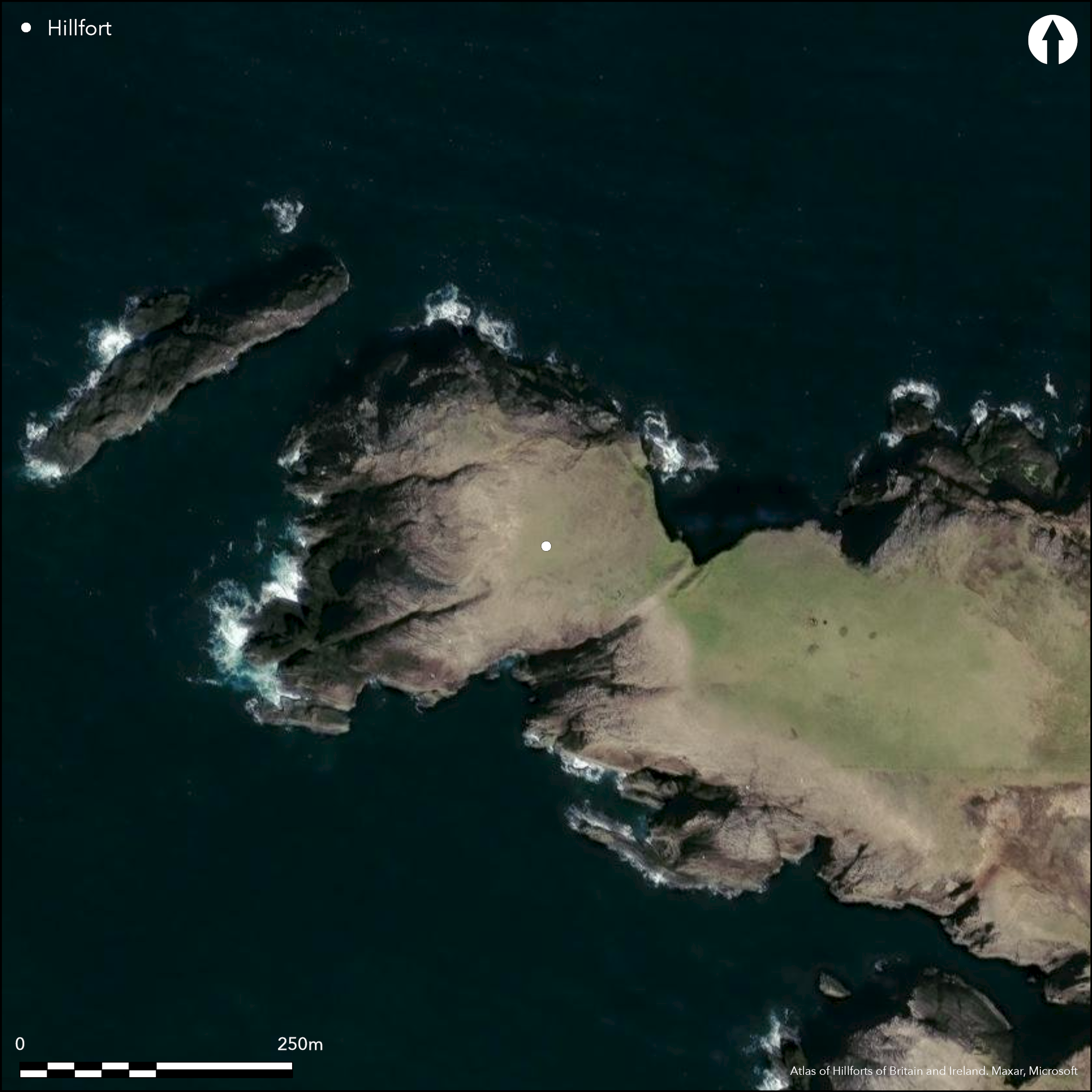
Satellite Imagery
Satellite Imagery
HER: Archaeological Survey of Ireland SMR Database MA009-001001 (None)
NMR: MA 009 (None)
SM: None
NGR: None
X: 464489 Y: 837583 (IRENET95)
This coastal promontory is situated at 'Doonamo Point' SE of Eagle Island, c. 7.5km NW of Bellmulet village, Co. Mayo. Depicted as 'Doonamo' (cattle fort), an entrenched oval headland on the first edition OS six-inch map it projects W from the mainland at an altitude of 39m OD. It is located in an area of rough sheep grazing and open bogland. First described in 1752, the coastal promontory has been visited by many with tradition suggesting that it was built by the burkes and besieged and taken by the Danes. Others state that it was built 'in the time of Queen Elizabeth' while local folklore suggests that during the 'battle of Cross' the local inhabitants penned their cattle in the headland for safety, hence the name 'cattle fort' (Pococke 1752; Trotter 1819; O'Donovan 1838; Browne 1895; Westropp 1912, 201). The defences consist of an inner stone rampart, an external ditch and a low outer or counterscarp bank running across the neck of the headland. Outside this, to the E are what has been interpreted as the remains of chevaux de frise, which have been dismissed more recently as the remains of a children's burial ground (Casey 1999). It was described as of 'great height and size' in 1817, but reduced in size by the natives who took many of the pillar stones for lintels and sills (Otway 1845). The inner wall is a massive dry-stone structure of thin slabs, extending 15m to the NE and 19.8m to the SW of the central gateway. It is 6m wide in the middle, reducing to 4.2m to the NE; it is up to 2.4m high at the SW end, and in places its crest stands up to 5.1m above the bottom of the ditch. The ditch exploits a natural fault on the SW and a broken cleft on the NE which has been cut away by the sea; it is up to 6.7m wide at the top and 1.8m at the base at a depth of 2.1m, but is partly filled with rubble that has spilled down from the inner wall. On the NE side of the entrance the outer bank is 5m in width and up to 1.2m high. The entrance causeway across the ditch is flanked by grass-covered banks on either side, and there are recumbent flagstones lying on either side of the gap in the main wall; two mural/guard chambers described by Westropp flanking the entrance are no longer visible, but a circular depression on the NE side of the causeway, which is 4.5m in diameter, may be the remains of a circular hut guarding the entrance (Casey 1999, 67). Within the interior, two smaller depressions immediately inside the main wall on the SW of the entrance may be the remains of conjoined huts, while immediately to the N of the entrance is another possible hut-site. The interior of the fort rises up to its highest point near the W end of the promontory, where, about 75m from the defences, the remains of a possible stone cashel-type enclosure measuring c. 36m in diameter can be seen. Its wall survives only on the E and N, where it is up to 4m thick and up to 0.8m high. Nearer to the entrance are the remains of a possible rectangular building composed of stone. A single trench was cut across the line of defences in 1992 (Casey 1999). The excavation revealed that the main bank was originally faced on both sides with an internal rubble core. Tentative remains of terracing was also revealed. The ditch was V-shaped with steep sides and was partly rock-cut, revetted along its outer face with 4-5 courses of stonework. Importantly, the excavation concluded that the chevaux de frise was not likely to be contemporary with the construction of the fort as the erection of the uprights took place after the old sod level was buried.
Citizen Science: ✗
Reliability of Data: Confirmed
Reliability of Interpretation: Confirmed
X: -1122149 Y: 7221283 (EPSG: 3857)
Longitude: -10.08043557065755 Latitude: 54.2690809528984 (EPSG:4326)
Country: Republic of Ireland
Current County or Unitary Authority: Mayo
Historic County: Mayo
Current Parish/Community/Council/Townland: Aughernagailliagh
The defences have suffered significant deterioration since surveyed by Westropp. Casey suggests that this may have taken place in the early-mid twentieth century in order to accommodate the military needs of the local FCA (F†rsa Cosanta iti–il) who used the site during the Emergency.
| Extant | ✓ |
| Cropmark | ✗ |
| Likely Destroyed | ✗ |
It is located in an upland area of rough sheep grazing and open bogland
| Woodland | ✗ |
| Commercial Forestry Plantation | ✗ |
| Parkland | ✗ |
| Pasture (Grazing) | ✓ |
| Arable | ✗ |
| Scrub/Bracken | ✗ |
| Bare Outcrop | ✗ |
| Heather/Moorland | ✓ |
| Heath | ✗ |
| Built-up | ✗ |
| Coastal Grassland | ✗ |
| Other | ✗ |
Depicted as 'Doonamo' (cattle fort), an entrenched oval headland on the first edition OS six-inch map it projects W from the mainland at an altitude of 39m OD. It is located in an upland area of rough sheep grazing and open bogland. The defences consist of an inner stone rampart, an external ditch and a low couterscarp bank running across the narrowest part of the headland. Outside this, to the E are the remains of chevaux de frise which have been dismissed as the remains of a children's burial ground (Casey 1999).
| Contour Fort | ✗ |
| Partial Contour Fort | ✗ |
| Promontory Fort | ✓ |
| Hillslope Fort | ✗ |
| Level Terrain Fort | ✗ |
| Marsh Fort | ✗ |
| Multiple Enclosure Fort | ✗ |
| Hilltop | ✗ |
| Coastal Promontory | ✓ |
| Inland Promontory | ✗ |
| Valley Bottom | ✗ |
| Knoll/Hillock/Outcrop | ✗ |
| Ridge | ✗ |
| Cliff/Plateau-edge/Scarp | ✗ |
| Hillslope | ✗ |
| Lowland | ✗ |
| Spur | ✗ |
Dominant Topographic Feature: W-facing promontory
| North | ✗ |
| Northeast | ✗ |
| East | ✗ |
| Southeast | ✗ |
| South | ✗ |
| Southwest | ✗ |
| West | ✓ |
| Northwest | ✗ |
| Level | ✗ |
Altitude: 39.0m
N/A
There is no dating available for the site. No artefacts or environmental remains were recovered during excavation.
Reliability: D - None
| Pre 1200BC | ✗ |
| 1200BC - 800BC | ✗ |
| 800BC - 400BC | ✗ |
| 400BC - AD50 | ✗ |
| AD50 - AD400 | ✗ |
| AD400 - AD 800 | ✗ |
| Post AD800 | ✗ |
| Unknown | ✓ |
| Pre Hillfort: | None |
| Post Hillfort: | Site used as a military training ground for the FCA (F†rsa Cosanta iti–il) during the Emergency. Some features may have been levelled during this activity. A childrens burial ground once interpreted as possible Chevaux de Fris is located immediately outside the defences to the NW. |
Depicted as 'Doonamo' (cattle fort), an entrenched oval headland on the first edition OS six-inch map. First described in 1752, the coastal promotnory has been visited by many with tradition suggesting that it was built by the burkes and besieged and taken by the Danes. Others state that it was built 'in the time of Queen Elizabeth', while local folklore suggests that during the 'battle of Cross' the local inhabitants penned their cattle in the headland for safety, hence the name 'cattle fort' (Pococke 1752; Trotter 1819; O'Donovan 1838; Browne 1895; Westropp 1912, 201).
| 1st Identified Written Reference (1752): | Pococke |
| Other (1819): | Trotter |
| 1st Identified Map Depiction (1839): | OS six-inch mapping |
| Earthwork Survey (1841): | Ottway |
| Earthwork Survey (1895): | Browne |
| Earthwork Survey (1912): | Thomas Westropp |
| Excavation (1992): | Casey |
A circular depression on the NE side of the entrance causeway is 4.5m in diameter and may be the remains of a circular hut guarding the entrance (Casey 1999, 67). Two smaller depressions inside the main bank to the SW of the gap may be the remains of conjoined huts, while immediately to the N of the entrance is another possible hut-site. Two mural/guard chambers described by Westropp flanking the entrance are no longer visible. About 75m from the defences, at the W end of the promontory lie the remains of a possible stone cashel-type enclosure c. 36m in diameter. The wall only survives on the E and N, where it is 4m thick and up to 0.8m high. Nearer to the entrance are the remains of a possible rectangular stone building.
None
| None | ✓ |
| Spring | ✗ |
| Stream | ✗ |
| Pool | ✗ |
| Flush | ✗ |
| Well | ✗ |
| Other | ✗ |
A number of possible circular hut-sites are recorded at the entrance while a stone-built rectangular structure is recorded within the interior, along with a circular enclosure or possible cashel.
| No Known Features | ✗ |
| Round Stone Structures | ✓ |
| Rectangular Stone Structures | ✓ |
| Curvilinear Platforms | ✗ |
| Other Roundhouse Evidence | ✗ |
| Pits | ✗ |
| Quarry Hollows | ✗ |
| Other | ✓ |
None
| No Known Excavation | ✗ |
| Pits | ✗ |
| Postholes | ✗ |
| Roundhouses | ✗ |
| Rectangular Structures | ✗ |
| Roads/Tracks | ✗ |
| Quarry Hollows | ✗ |
| Other | ✗ |
| Nothing Found | ✓ |
None
| No Known Geophysics | ✓ |
| Pits | ✗ |
| Roundhouses | ✗ |
| Rectangular Structures | ✗ |
| Roads/Tracks | ✗ |
| Quarry Hollows | ✗ |
| Other | ✗ |
| Nothing Found | ✗ |
20th century bullet recovered from the ditch fill.
| No Known Finds | ✗ |
| Pottery | ✗ |
| Metal | ✓ |
| Metalworking | ✗ |
| Human Bones | ✗ |
| Animal Bones | ✗ |
| Lithics | ✗ |
| Environmental | ✗ |
| Other | ✗ |
NO APPARENT FEATURES
| APs Not Checked | ✓ |
| None | ✗ |
| Roundhouses | ✗ |
| Rectangular Structures | ✗ |
| Pits | ✗ |
| Postholes | ✗ |
| Roads/Tracks | ✗ |
| Other | ✗ |
The entrance causeway is flanked by a grass-covered bank on either side with associated recumbent flagstones on either side of the gap in the main rampart, which is c. 1m wide. A circular depression to the N of the causeway is 4.5m in diameter and may be the remains of a circular hut which guarded the entrance (Casey 1999, 67). Otway (1841) described a possible lintelled entrance with associated bee-hive huts, but these are no longer visible.
| 1: | None |
| 2: | None |
Guard Chambers: ✗
Chevaux de Frise: ✓
Outside the defences, to the NE are the remains of what has been interpreted as a chevaux de frise but which more recently has been dismissed as the remains of a children's burial ground (Casey 1999).
| 1. Passage-way/Corridor (South east): | None |
The defences consist of an inner stone rampart, an external ditch and a low outer or counterscarp ban running across the neck on the SE. Outside this, to theNE are the remains of what has been interpreted as chevaux de fris, but which more recently has been dismissed as the remains of a children's burial ground (Casey 1999). Inside the Chevaux de Fris to the W is a shallow hollow beside an earthen/stone bank curving around 4.5m past a broken cleft which has been cut away by the sea. It is 5m in width and stands to a height of 1.2m. The ditch lies inside a rock cutting along a stream in a natural fault to the S. It is 1.8m wide at the base, 6.7m wide at the top and 2.1m deep and is stone revetted, filled with rubble from the inner stone bank. Inside this to the N is a low bank along which is a massive wall of dry stone composed of thin slabs, much of which had already 'fallen into ruinous heaps' in the early 20th century (Westropp 1912, 203). It extends 15m to the N and 19.8m to the S of the gateway. It is 6m wide in the middle, 4.2m to the N and c. 2.4m high at the S end. It rises 5.1m over the ditch.
| Area 1: | 1.21ha. |
| Total: | 1.21ha. |
Total Footprint Area: 1.52ha.
None
| ✗ | The grass-grown interior gives way to bare rock where it descends towards the sea on the N and W |
| ✗ | None |
| NE Quadrant: | 0 |
| SE Quadrant: | 2 |
| SW Quadrant: | 0 |
| NW Quadrant: | 0 |
| Total: | 2 |
| Partial Univallate | ✗ |
| Univallate | ✗ |
| Partial Bivallate | ✓ |
| Bivallate | ✗ |
| Partial Multivallate | ✗ |
| Multivallate | ✗ |
| Unknown | ✗ |
| Partial Univallate | ✗ |
| Univallate | ✗ |
| Partial Bivallate | ✗ |
| Bivallate | ✗ |
| Partial Multivallate | ✗ |
| Multivallate | ✗ |
None
| None | ✗ |
| Earthen Bank | ✓ |
| Stone Wall | ✓ |
| Rubble | ✗ |
| Wall-walk | ✗ |
| Evidence of Timber | ✗ |
| Vitrification | ✗ |
| Other Burning | ✗ |
| Palisade | ✗ |
| Counter Scarp Bank | ✗ |
| Berm | ✗ |
| Unfinished | ✗ |
| Other | ✗ |
None
| None | ✗ |
| Earthen Bank | ✓ |
| Stone Wall | ✓ |
| Murus Duplex | ✗ |
| Timber-framed | ✗ |
| Timber-laced | ✗ |
| Vitrification | ✗ |
| Other Burning | ✗ |
| Palisade | ✗ |
| Counter Scarp Bank | ✗ |
| Berm | ✗ |
| Unfinished | ✗ |
| No Known Excavation | ✗ |
| Other | ✗ |
| ✗ | None |
| ✓ | None |
Number of Ditches: 2
| ✗ | None |
Browne, C. 1895. The ethnography of the Mullet, Inishkea Islands, and Portnacloy, Co. Mayo. Proceedings of the Royal Irish Academy 19 587- 637
Casey, M. 1999 The coastal promontory forts of Ireland. A survey of counties Sligo, Mayo, Galway and Clare. Unpublished MA thesis, National University of Ireland, Galway
Harbison, P 1971 Wooden and stone chevaux-de frise in central and western Europe. Proc Prehist Soc 37 (1971), 195-225 (206-7, fig 11)
O'Donovan, J. 1838. Ordnance Survey Letters, Co. Mayo
Otway, C. 1841. Sketches in Erris and Tirawley. Dublin
Pococke, R. 1752. Pococke's Tour of Ireland (ed. G. Stokes), Dublin 1891.
Trotter, J. B. 1819. Walks through Ireland in the years 1812, 1814 and 1817. London.
Westropp, T.J. 1912. The promontory forts and early remains of the coasts of County Mayo. Part 1- The north coast (Tirawley and Erris). The Journal of the Royal Society of Antiquaries of Ireland 42, 59-139.
Atlas of Hillforts:
Wikidata:
This work is licensed under CC BY-SA 4.0

 and should be cited as:
Lock, Gary and Ralston, Ian. 2024. Atlas of Hillforts of Britain and Ireland. Available at: https://hillforts.arch.ox.ac.uk
Document Version 1.1