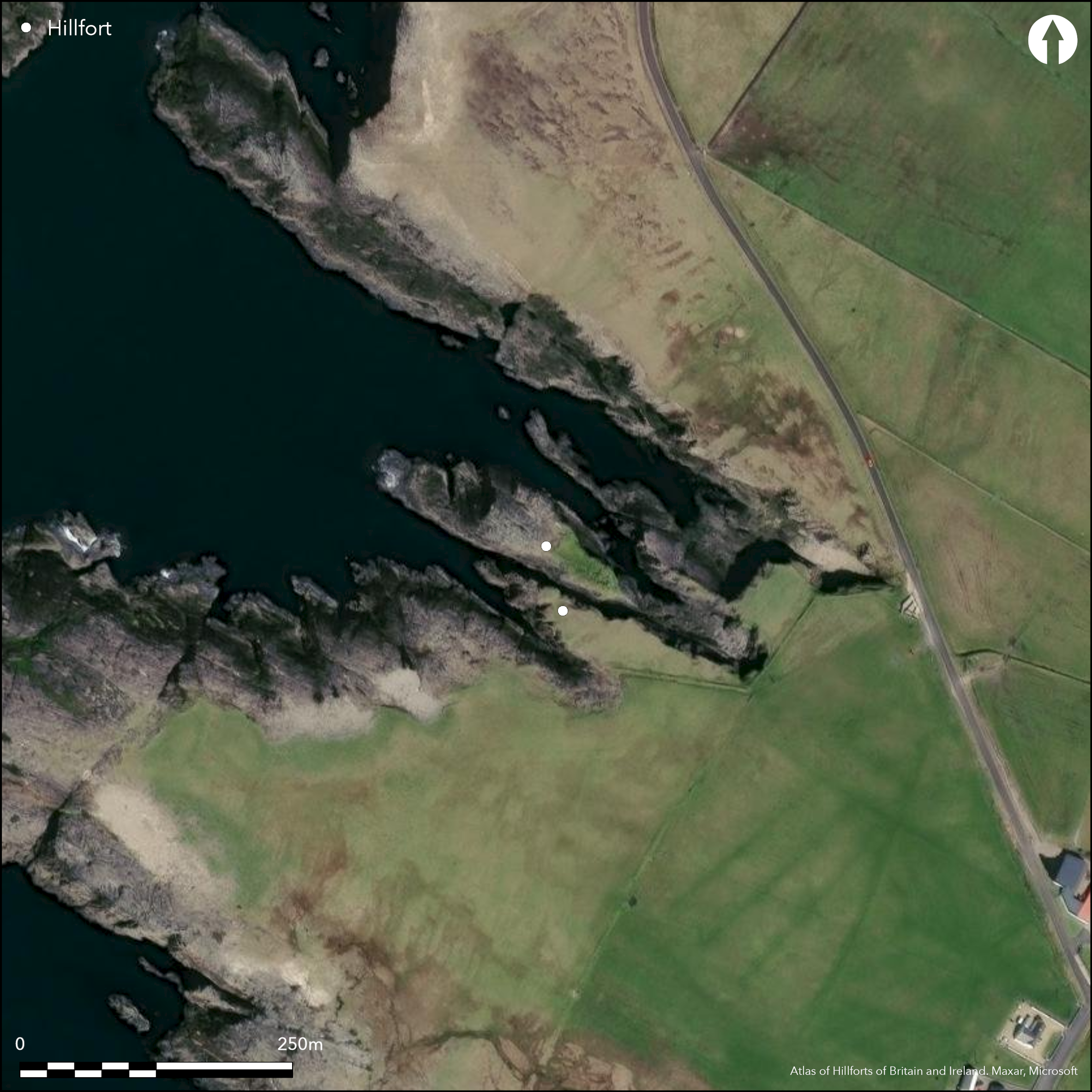
Satellite Imagery
Satellite Imagery
HER: Archaeological Survey of Ireland SMR Database MA009-002001 (None)
NMR: MA 009 (None)
SM: None
NGR: None
X: 464725 Y: 836674 (IRENET95)
This coastal promontory is situated S of Dunnamo Point, c. 0.37km S of a natural subterranean passage known as 'Poulashantana'. Depicted on the first edition OS six-inch map (1839) as 'Doonaneanir' (one mans fort), it was first noted by Pococke in 1752 as 'a small detached rock which had some fortification on it'. Dr Browne noted in 1894 that the 'Priests Leap' was located near Dunnamo not far from this dangerous little pit, also called Poulashantana'. It is little more than a stack now, isolated from the mainland and accessed only by 'descending a breakneck gully near it, and crossing a causeway of low reef' (Westropp 1912, 206). A wall composed of thin flagstones and 2m-3m high encloses an oval area on the summit measuring 51.8m E-W by 12m to 18m transversely, while the seaward third of the stack is reduced to bare rock. The stack was probably reached by a natural arch which has since fallen into the sea.
Citizen Science: ✗
Reliability of Data: Confirmed
Reliability of Interpretation: Confirmed
X: -1121700 Y: 7219739 (EPSG: 3857)
Longitude: -10.076404600907319 Latitude: 54.26098090186242 (EPSG:4326)
Country: Republic of Ireland
Current County or Unitary Authority: Mayo
Historic County: Mayo
Current Parish/Community/Council/Townland: Gladree
None
| Extant | ✓ |
| Cropmark | ✗ |
| Likely Destroyed | ✗ |
None
| Woodland | ✗ |
| Commercial Forestry Plantation | ✗ |
| Parkland | ✗ |
| Pasture (Grazing) | ✗ |
| Arable | ✗ |
| Scrub/Bracken | ✗ |
| Bare Outcrop | ✗ |
| Heather/Moorland | ✗ |
| Heath | ✗ |
| Built-up | ✗ |
| Coastal Grassland | ✗ |
| Other | ✗ |
This fortified rock is now isolated from the mainland and accessed only by 'descending a breakneck gully near it, and crossing a causeway of low reef' (Westropp 1912, 206). A wall 2m-3m high and composed of thin flagstones skirts around the entire perimeter of the headland
| Contour Fort | ✗ |
| Partial Contour Fort | ✗ |
| Promontory Fort | ✓ |
| Hillslope Fort | ✗ |
| Level Terrain Fort | ✗ |
| Marsh Fort | ✗ |
| Multiple Enclosure Fort | ✗ |
| Hilltop | ✗ |
| Coastal Promontory | ✓ |
| Inland Promontory | ✗ |
| Valley Bottom | ✗ |
| Knoll/Hillock/Outcrop | ✗ |
| Ridge | ✗ |
| Cliff/Plateau-edge/Scarp | ✗ |
| Hillslope | ✗ |
| Lowland | ✗ |
| Spur | ✗ |
Dominant Topographic Feature: The site is overlooked to the N by another headland.
| North | ✗ |
| Northeast | ✗ |
| East | ✗ |
| Southeast | ✗ |
| South | ✗ |
| Southwest | ✗ |
| West | ✗ |
| Northwest | ✓ |
| Level | ✗ |
Altitude: 5.0m
N/A
There is no dating available for the site
Reliability: D - None
| Pre 1200BC | ✗ |
| 1200BC - 800BC | ✗ |
| 800BC - 400BC | ✗ |
| 400BC - AD50 | ✗ |
| AD50 - AD400 | ✗ |
| AD400 - AD 800 | ✗ |
| Post AD800 | ✗ |
| Unknown | ✓ |
| Pre Hillfort: | None |
| Post Hillfort: | None |
Depicted on the first edition OS six-inch map (1839) as 'Doonaneanir' (one mans fort) it was first noted by Pococke in 1752 as 'a small detached rock which had some fortification on it'. Dr Browne noted in 1894 that the 'Priests Leap' was located near Dunnamo not far from this dangerous little pit, also called Poulashantana'. Visited and surveyed by Westropp in 1912.
| 1st Identified Written Reference (1752): | Pococke |
| 1st Identified Map Depiction (1839): | OS six-inch mapping |
| Other (1894): | Browne |
| Earthwork Survey (1912): | Thomas Westropp |
There are no recorded internal features
None
| None | ✓ |
| Spring | ✗ |
| Stream | ✗ |
| Pool | ✗ |
| Flush | ✗ |
| Well | ✗ |
| Other | ✗ |
None
| No Known Features | ✓ |
| Round Stone Structures | ✗ |
| Rectangular Stone Structures | ✗ |
| Curvilinear Platforms | ✗ |
| Other Roundhouse Evidence | ✗ |
| Pits | ✗ |
| Quarry Hollows | ✗ |
| Other | ✗ |
None
| No Known Excavation | ✓ |
| Pits | ✗ |
| Postholes | ✗ |
| Roundhouses | ✗ |
| Rectangular Structures | ✗ |
| Roads/Tracks | ✗ |
| Quarry Hollows | ✗ |
| Other | ✗ |
| Nothing Found | ✗ |
None
| No Known Geophysics | ✓ |
| Pits | ✗ |
| Roundhouses | ✗ |
| Rectangular Structures | ✗ |
| Roads/Tracks | ✗ |
| Quarry Hollows | ✗ |
| Other | ✗ |
| Nothing Found | ✗ |
None
| No Known Finds | ✓ |
| Pottery | ✗ |
| Metal | ✗ |
| Metalworking | ✗ |
| Human Bones | ✗ |
| Animal Bones | ✗ |
| Lithics | ✗ |
| Environmental | ✗ |
| Other | ✗ |
NO APPARENT FEATURES
| APs Not Checked | ✓ |
| None | ✗ |
| Roundhouses | ✗ |
| Rectangular Structures | ✗ |
| Pits | ✗ |
| Postholes | ✗ |
| Roads/Tracks | ✗ |
| Other | ✗ |
The stack was probably reached by a natural arch which has since fallen into the sea
| 0: | None |
| 2: | None |
Guard Chambers: ✗
Chevaux de Frise: ✗
A wall 2m-3m high and composed of thin flagstones encloses an oval area measuring 51.8m E-W by 12m to 18m transversely
| Area 1: | 0.03ha. |
| Total: | 0.03ha. |
Total Footprint Area: 0.1ha.
None
| ✗ | None |
| ✓ | None |
| NE Quadrant: | 1 |
| SE Quadrant: | 1 |
| SW Quadrant: | 1 |
| NW Quadrant: | 1 |
| Total: | 1 |
| Partial Univallate | ✗ |
| Univallate | ✓ |
| Partial Bivallate | ✗ |
| Bivallate | ✗ |
| Partial Multivallate | ✗ |
| Multivallate | ✗ |
| Unknown | ✗ |
| Partial Univallate | ✗ |
| Univallate | ✗ |
| Partial Bivallate | ✗ |
| Bivallate | ✗ |
| Partial Multivallate | ✗ |
| Multivallate | ✗ |
None
| None | ✗ |
| Earthen Bank | ✗ |
| Stone Wall | ✓ |
| Rubble | ✗ |
| Wall-walk | ✗ |
| Evidence of Timber | ✗ |
| Vitrification | ✗ |
| Other Burning | ✗ |
| Palisade | ✗ |
| Counter Scarp Bank | ✗ |
| Berm | ✗ |
| Unfinished | ✗ |
| Other | ✗ |
None
| None | ✗ |
| Earthen Bank | ✗ |
| Stone Wall | ✗ |
| Murus Duplex | ✗ |
| Timber-framed | ✗ |
| Timber-laced | ✗ |
| Vitrification | ✗ |
| Other Burning | ✗ |
| Palisade | ✗ |
| Counter Scarp Bank | ✗ |
| Berm | ✗ |
| Unfinished | ✗ |
| No Known Excavation | ✓ |
| Other | ✗ |
| ✗ | None |
| ✗ | None |
Number of Ditches: 0
| ✗ | None |
Browne, C. 1895. The ethnography of the Mullet, Inishkea Islands, and Portnacloy, Co. Mayo. Proceedings of the Royal Irish Academy 19 587- 637
Pococke, R. 1752. Pococke's Tour of Ireland (ed. G. Stokes), Dublin 1891.
Westropp, T.J. 1912. The promontory forts and early remains of the coasts of County Mayo. Part 1- The north coast (Tirawley and Erris). The Journal of the Royal Society of Antiquaries of Ireland 42, 59-139.
Atlas of Hillforts:
Wikidata:
This work is licensed under CC BY-SA 4.0

 and should be cited as:
Lock, Gary and Ralston, Ian. 2024. Atlas of Hillforts of Britain and Ireland. Available at: https://hillforts.arch.ox.ac.uk
Document Version 1.1