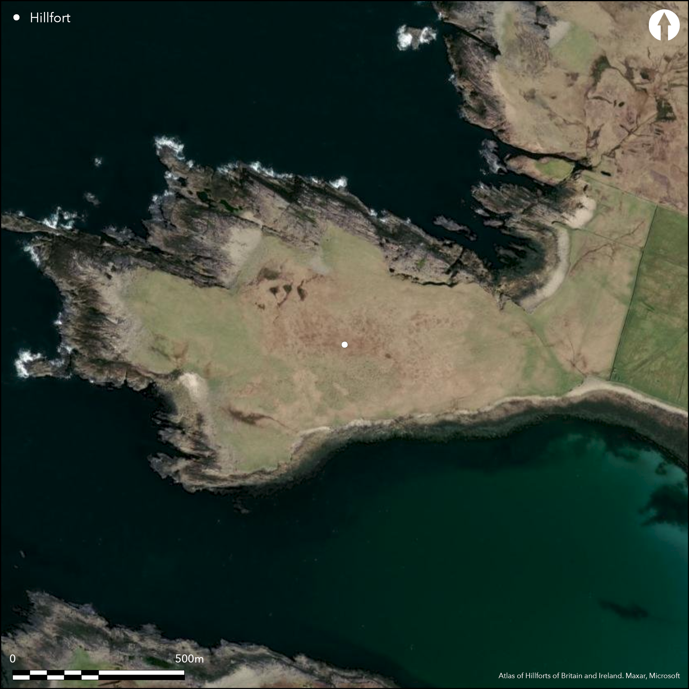
Satellite Imagery
Satellite Imagery
HER: Archaeological Survey of Ireland SMR Database MA009-005001 (None)
NMR: MA 009 (None)
SM: None
NGR: None
X: 463902 Y: 835245 (IRENET95)
This large coastal promontory is situated at 'Port Point' adjacent to 'Portnafrankagh Bay', c. 6km NW of Belmullet Co. Mayo. It is not annotated on any edition of the OS six-inch maps. Noted by Otway in 1845 who records that local folklore says that 'the last inhabitant of Porth Fort was a desperate tyrant, Shane Gill' who was drowned by the local inhabitants due to his cruelty. The promontory forms an irregular headland that projects W from the mainland between 'Portnafrankagh Bay' and 'Doonaderg' inlet, rising gently out of the low-lying neck on the E. At the lowest point of the neck a massive stone wall has been drawn across the headland from NNW to SSE. It is 3m thick, composed of large blocks and has a maximum height of 1.5m. At the southern end a stone-faced bank turns to the SW and continues and though virtually levelled after a short distance, its line is traceable to the shore of Portnafrankagh Bay. The stones in the N section are up to 1.2m long and 0.6m thick (Westropp 1912, 210). Westropp describes one gateway in the middle of the neck, and also mentions a second; stone lintels lay outside both gates. The interior of the promontory extends to about 18ha, and on a low rocky ridge c. 35m from the wall, the foundations of a group of hut-sites and two souterrains can be seen, largely surrounded by an area of cultivation ridges (SH).
Citizen Science: ✗
Reliability of Data: Confirmed
Reliability of Interpretation: Confirmed
X: -1123033 Y: 7217252 (EPSG: 3857)
Longitude: -10.088379294561578 Latitude: 54.24793093402015 (EPSG:4326)
Country: Republic of Ireland
Current County or Unitary Authority: Mayo
Historic County: Mayo
Current Parish/Community/Council/Townland: Termoncarragh
None
| Extant | ✓ |
| Cropmark | ✗ |
| Likely Destroyed | ✗ |
None
| Woodland | ✗ |
| Commercial Forestry Plantation | ✗ |
| Parkland | ✗ |
| Pasture (Grazing) | ✓ |
| Arable | ✗ |
| Scrub/Bracken | ✗ |
| Bare Outcrop | ✗ |
| Heather/Moorland | ✓ |
| Heath | ✗ |
| Built-up | ✗ |
| Coastal Grassland | ✗ |
| Other | ✗ |
This large coastal promontory is situated at 'Port Point' adjacent to 'Portnafrankagh Bay', c. 6km NW of Belmullet Co. Mayo. It is an irregular headland that projects W from the mainland between 'Portnafrankagh Bay' and 'Doonaderg' inlet. It is defended at the lowest point of the neck of the headland by a massive stone wall running N-S for a distance of 88m.
| Contour Fort | ✗ |
| Partial Contour Fort | ✗ |
| Promontory Fort | ✓ |
| Hillslope Fort | ✗ |
| Level Terrain Fort | ✗ |
| Marsh Fort | ✗ |
| Multiple Enclosure Fort | ✗ |
| Hilltop | ✗ |
| Coastal Promontory | ✓ |
| Inland Promontory | ✗ |
| Valley Bottom | ✗ |
| Knoll/Hillock/Outcrop | ✗ |
| Ridge | ✗ |
| Cliff/Plateau-edge/Scarp | ✗ |
| Hillslope | ✗ |
| Lowland | ✗ |
| Spur | ✗ |
Dominant Topographic Feature: None
| North | ✗ |
| Northeast | ✗ |
| East | ✗ |
| Southeast | ✗ |
| South | ✗ |
| Southwest | ✗ |
| West | ✗ |
| Northwest | ✓ |
| Level | ✗ |
Altitude: 10.0m
N/A
There is no dating available for the site
Reliability: D - None
| Pre 1200BC | ✗ |
| 1200BC - 800BC | ✗ |
| 800BC - 400BC | ✗ |
| 400BC - AD50 | ✗ |
| AD50 - AD400 | ✗ |
| AD400 - AD 800 | ✗ |
| Post AD800 | ✗ |
| Unknown | ✓ |
| Pre Hillfort: | None |
| Post Hillfort: | None |
The promontory is not annotated on any edition of the OS six-inch maps. Noted by Otway in 1845, who records that local folklore says that 'the last inhabitant of Porth Fort was a desperate tyrant, Shane Gill' who was drowned by the local inhabitants due to his cruelty. Browne (1895) calls the site 'an earthen d–n, barely traceable'. Visited and surveyed by Westropp in 1912 who recorded defences and internal features.
| 1st Identified Written Reference (1845): | Otway |
| Other (1895): | Charles Browne |
| Earthwork Survey (1912): | Thomas Westropp |
Inside the promontory, on a low rocky ridge c. 35m behind the wall, are the foundations of a group of hut-sites and a souterrain. From S to N they comprise: a cell with an aumbry; a curved souterrain 6.4m long; a larger circular hut-site 5.4m across; a hut with two cells; 10m further N another souterrain; two huts; a hut-garth with a wall 1.8m thick and two rooms; and beside it a nearly levelled hut, 6.4m overall.
None
| None | ✓ |
| Spring | ✗ |
| Stream | ✗ |
| Pool | ✗ |
| Flush | ✗ |
| Well | ✗ |
| Other | ✗ |
hut-sites and souterrains
| No Known Features | ✗ |
| Round Stone Structures | ✓ |
| Rectangular Stone Structures | ✗ |
| Curvilinear Platforms | ✗ |
| Other Roundhouse Evidence | ✗ |
| Pits | ✗ |
| Quarry Hollows | ✗ |
| Other | ✓ |
None
| No Known Excavation | ✓ |
| Pits | ✗ |
| Postholes | ✗ |
| Roundhouses | ✗ |
| Rectangular Structures | ✗ |
| Roads/Tracks | ✗ |
| Quarry Hollows | ✗ |
| Other | ✗ |
| Nothing Found | ✗ |
None
| No Known Geophysics | ✓ |
| Pits | ✗ |
| Roundhouses | ✗ |
| Rectangular Structures | ✗ |
| Roads/Tracks | ✗ |
| Quarry Hollows | ✗ |
| Other | ✗ |
| Nothing Found | ✗ |
None
| No Known Finds | ✓ |
| Pottery | ✗ |
| Metal | ✗ |
| Metalworking | ✗ |
| Human Bones | ✗ |
| Animal Bones | ✗ |
| Lithics | ✗ |
| Environmental | ✗ |
| Other | ✗ |
NO APPARENT FEATURES
| APs Not Checked | ✓ |
| None | ✗ |
| Roundhouses | ✗ |
| Rectangular Structures | ✗ |
| Pits | ✗ |
| Postholes | ✗ |
| Roads/Tracks | ✗ |
| Other | ✗ |
Westropp describes two gateways, one of which lies roughly in the middle of the neck. Stone lintels lie outside both gates. No other information available.
| 2: | None |
| 2: | None |
Guard Chambers: ✗
Chevaux de Frise: ✗
| 1. Simple Gap (South east): | None |
| 1. Simple Gap (South east): | None |
At the lowest point of the neck a massive stone wall has been drawn across the headland from NNW to SSE. It is 3m thick, composed of large blocks and has a maximum height of 1.5m. At the southern end a stone-faced bank turns to the SW and continues and though virtually levelled after a short distance, its line is traceable to the shore of Portnafrankagh Bay. The stones in the N section are up to 1.2m long and 0.6m thick (Westropp 1912, 210).
| Area 1: | 18.2ha. |
| Total: | 18.2ha. |
Total Footprint Area: 18.4ha.
None
| ✗ | None |
| ✗ | None |
| NE Quadrant: | 0 |
| SE Quadrant: | 1 |
| SW Quadrant: | 0 |
| NW Quadrant: | 0 |
| Total: | 1 |
| Partial Univallate | ✓ |
| Univallate | ✗ |
| Partial Bivallate | ✗ |
| Bivallate | ✗ |
| Partial Multivallate | ✗ |
| Multivallate | ✗ |
| Unknown | ✗ |
| Partial Univallate | ✗ |
| Univallate | ✗ |
| Partial Bivallate | ✗ |
| Bivallate | ✗ |
| Partial Multivallate | ✗ |
| Multivallate | ✗ |
None
| None | ✗ |
| Earthen Bank | ✗ |
| Stone Wall | ✓ |
| Rubble | ✗ |
| Wall-walk | ✗ |
| Evidence of Timber | ✗ |
| Vitrification | ✗ |
| Other Burning | ✗ |
| Palisade | ✗ |
| Counter Scarp Bank | ✗ |
| Berm | ✗ |
| Unfinished | ✗ |
| Other | ✗ |
None
| None | ✗ |
| Earthen Bank | ✗ |
| Stone Wall | ✗ |
| Murus Duplex | ✗ |
| Timber-framed | ✗ |
| Timber-laced | ✗ |
| Vitrification | ✗ |
| Other Burning | ✗ |
| Palisade | ✗ |
| Counter Scarp Bank | ✗ |
| Berm | ✗ |
| Unfinished | ✗ |
| No Known Excavation | ✓ |
| Other | ✗ |
| ✗ | None |
| ✗ | None |
Number of Ditches: 0
| ✗ | None |
Browne, C. 1895. The ethnography of the Mullet, Inishkea Islands, and Portnacloy, Co. Mayo. Proceedings of the Royal Irish Academy 19 587- 637
Otway, C. 1841. Sketches in Erris and Tirawley. Dublin
Westropp, T.J. 1912. The promontory forts and early remains of the coasts of County Mayo. Part 1- The north coast (Tirawley and Erris). The Journal of the Royal Society of Antiquaries of Ireland 42, 59-139.
Atlas of Hillforts:
Wikidata:
This work is licensed under CC BY-SA 4.0

 and should be cited as:
Lock, Gary and Ralston, Ian. 2024. Atlas of Hillforts of Britain and Ireland. Available at: https://hillforts.arch.ox.ac.uk
Document Version 1.1