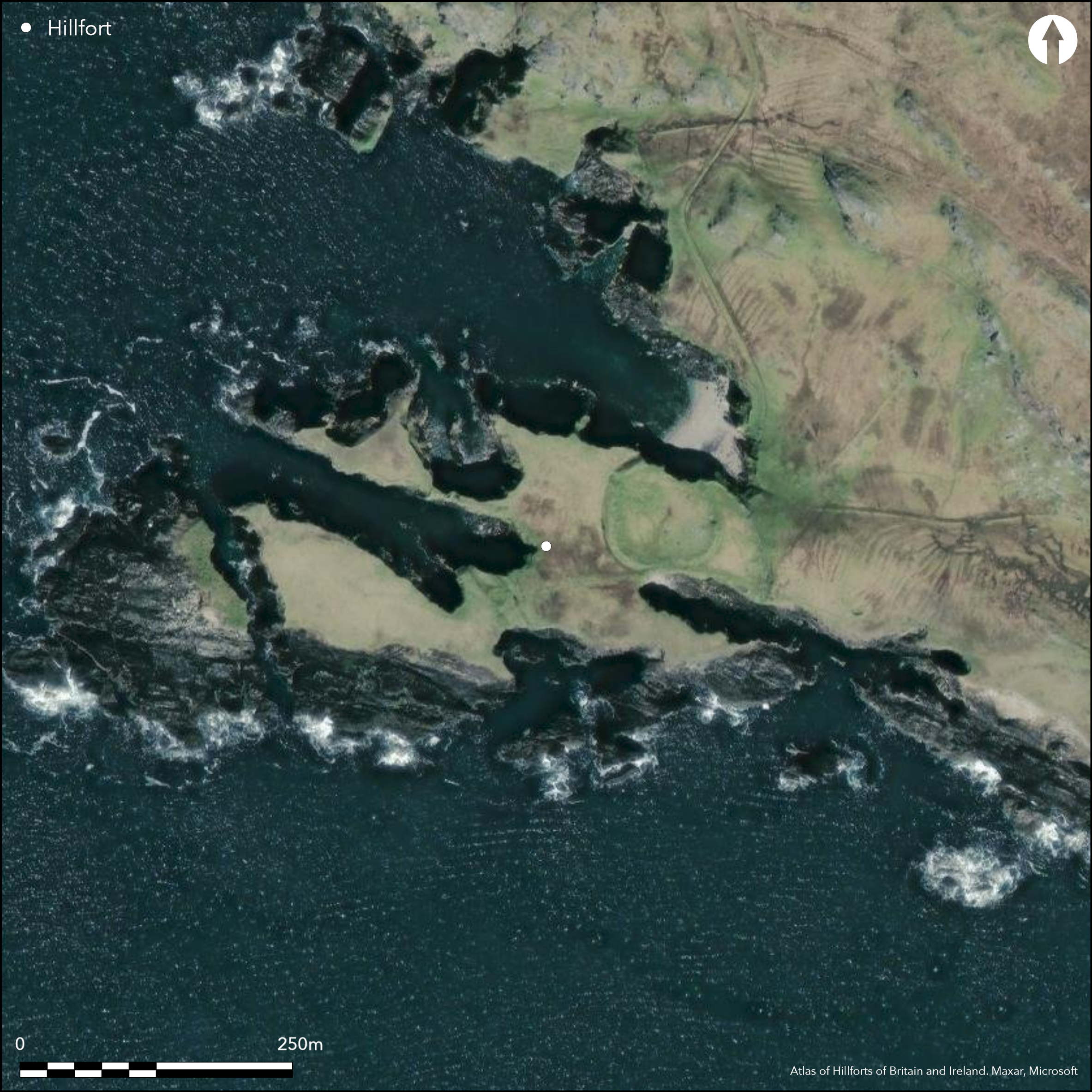
Satellite Imagery
Satellite Imagery
HER: Archaeological Survey of Ireland SMR Database MA075-001001 (None)
NMR: MA 075 (None)
SM: None
NGR: None
X: 470811 Y: 792589 (IRENET95)
This large headland is broken into a series of subsidiary promontories, each with its own defences, and at the seaward end there is also an isolated grassy stack. Depicted as' Dun Kilmore', 'The D–n' and 'The Dancan' respectively on the second edition OS six-inch maps, they are situated on the W side of Achill Beg island off the W coast of Co. Mayo. The outermost defences are those named 'D–n Kilmore', which comprise a curved ditch 3m wide and 1.2m deep drawn across easternmost neck joining the headland to the mainland of the island. Its rampart is an earthen, externally stone-faced bank c. 6m thick and standing 3m above the bottom of the external ditch and 1.5m high internally. The external facing is composed of slab stonework in level courses with a well-constructed batter, and has been carried back westwards in a gentle curve along the cliff-edge on the N of the neck. On the E it has an entrance 1.8m wide lined with large slabs. Between this and a ringfort that spans the neck immediately to the rear of these defences, kerb of slabs barely rising above the ground was noted by Westropp running NNW and SSE (Westropp 1914, 314). The ringfort measures 52m in diameter within a bank with an external ditch; a graveyard and other associated structures of possible early medieval date lie within its interior. The second of the three promontory fortifications lies 130m to the W of the defences of Dun Kilmore, and occupies the southern arm of the headland. Known as 'The D–n', its defences comprise three banks with intermediate ditches that cut across the neck of the headland over a distance of 37m. The inner bank is 2m-3.5m wide, nearly levelled but once capped by stone rampart. The ditch outside it is 4.8m wide and in parts 2.1m deep. The middle bank was 4.8m wide with the foundation of a dry-stone wall on its outer edge, and the ditch between it and the outer bank 3m wide and 1.5m deep; the outer bank was in a bad state of repair when visited by Westropp in 1914, but was 2.4m wide. Westropp observed that at some later stage the middle of the inner ditch was filled and an early oval hut measuring 8.2m N-S by 9m E-W within walls 3m thick was constructed across its line. The third fortification, occupying the northern arm of the headland is known as 'The Dancan or Dangan' and is defended at the neck by the remains of a mortared wall. Outside the wall, however, is a bank and a drystone wall with an external ditch 8.5m wide and 2.7m deep; there are also faint traces of an outer wall. A causeway across the ditch lay at the N edge of the neck and Westropp notes that in 1909 a 'mortar-built gatehouse with rude loopholes stood in part to the N side but heavy rains had produced a slide of all the top soil and ruin' (1914, 314). The mortar-built inner wall of the gatehouse measured 3m thick and 1.2m high.
Citizen Science: ✗
Reliability of Data: Confirmed
Reliability of Interpretation: Confirmed
X: -1109218 Y: 7144941 (EPSG: 3857)
Longitude: -9.96427162391426 Latitude: 53.866647367090785 (EPSG:4326)
Country: Republic of Ireland
Current County or Unitary Authority: Mayo (Achill Beg)
Historic County: Mayo
Current Parish/Community/Council/Townland: Achill Beg
None
| Extant | ✓ |
| Cropmark | ✗ |
| Likely Destroyed | ✗ |
None
| Woodland | ✗ |
| Commercial Forestry Plantation | ✗ |
| Parkland | ✗ |
| Pasture (Grazing) | ✓ |
| Arable | ✗ |
| Scrub/Bracken | ✗ |
| Bare Outcrop | ✗ |
| Heather/Moorland | ✓ |
| Heath | ✗ |
| Built-up | ✗ |
| Coastal Grassland | ✗ |
| Other | ✗ |
This large headland is broken into subsidiary promontories, each with its own defences, and beyond the seaward end there is a further isolated grassy rock-stack. Depicted as' Dun Kilmore', 'The D–n' and 'The Dancan' on the second edition OS six-inch maps, the connected headlands are situated on the W side of Achill Beg island off the W coast of Co. Mayo.
| Contour Fort | ✗ |
| Partial Contour Fort | ✗ |
| Promontory Fort | ✓ |
| Hillslope Fort | ✗ |
| Level Terrain Fort | ✗ |
| Marsh Fort | ✗ |
| Multiple Enclosure Fort | ✓ |
| Hilltop | ✗ |
| Coastal Promontory | ✓ |
| Inland Promontory | ✗ |
| Valley Bottom | ✗ |
| Knoll/Hillock/Outcrop | ✗ |
| Ridge | ✗ |
| Cliff/Plateau-edge/Scarp | ✗ |
| Hillslope | ✗ |
| Lowland | ✗ |
| Spur | ✗ |
Dominant Topographic Feature: None
| North | ✗ |
| Northeast | ✓ |
| East | ✗ |
| Southeast | ✗ |
| South | ✗ |
| Southwest | ✗ |
| West | ✗ |
| Northwest | ✗ |
| Level | ✗ |
Altitude: 10.0m
N/A
There is no dating available for the site
Reliability: D - None
| Pre 1200BC | ✗ |
| 1200BC - 800BC | ✗ |
| 800BC - 400BC | ✗ |
| 400BC - AD50 | ✗ |
| AD50 - AD400 | ✗ |
| AD400 - AD 800 | ✗ |
| Post AD800 | ✗ |
| Unknown | ✓ |
| Pre Hillfort: | None |
| Post Hillfort: | Early Medieval ringfort and Medieval or Post-Medieval burial-ground along with a number of associated structures |
Depicted as' Dun Kilmore', 'The D–n' and 'The Dancan' on the second edition OS six-inch maps. Visited and surveyed by Thomas Westropp in 1914.
| 1st Identified Map Depiction (1839): | OS six-inch maps |
| 1st Identified Written Reference (1914): | Thomas Westropp |
An earthen ringfort, 52m in diameter within a bank and ditch, spans the neck behind the outermost defences; a graveyard and other associated structures of possible early medieval date lie within the interior of the ringfort.
None
| None | ✓ |
| Spring | ✗ |
| Stream | ✗ |
| Pool | ✗ |
| Flush | ✗ |
| Well | ✗ |
| Other | ✗ |
Ringfort and burial-ground
| No Known Features | ✗ |
| Round Stone Structures | ✗ |
| Rectangular Stone Structures | ✗ |
| Curvilinear Platforms | ✗ |
| Other Roundhouse Evidence | ✗ |
| Pits | ✗ |
| Quarry Hollows | ✗ |
| Other | ✓ |
None
| No Known Excavation | ✓ |
| Pits | ✗ |
| Postholes | ✗ |
| Roundhouses | ✗ |
| Rectangular Structures | ✗ |
| Roads/Tracks | ✗ |
| Quarry Hollows | ✗ |
| Other | ✗ |
| Nothing Found | ✗ |
None
| No Known Geophysics | ✓ |
| Pits | ✗ |
| Roundhouses | ✗ |
| Rectangular Structures | ✗ |
| Roads/Tracks | ✗ |
| Quarry Hollows | ✗ |
| Other | ✗ |
| Nothing Found | ✗ |
None
| No Known Finds | ✓ |
| Pottery | ✗ |
| Metal | ✗ |
| Metalworking | ✗ |
| Human Bones | ✗ |
| Animal Bones | ✗ |
| Lithics | ✗ |
| Environmental | ✗ |
| Other | ✗ |
NO APPARENT FEATURES
| APs Not Checked | ✓ |
| None | ✗ |
| Roundhouses | ✗ |
| Rectangular Structures | ✗ |
| Pits | ✗ |
| Postholes | ✗ |
| Roads/Tracks | ✗ |
| Other | ✗ |
Entrances are recorded at two of the three sets of defences on the large headland, one on the landward side (D–n Kilmore) through the ditch and stone wall and the other at the defences at Dangan and composed of a causeway over the ditch and a narrow gap through the inner wall.
| 2: | None |
| 2: | Each set of defences has only a single entrance |
Guard Chambers: ✗
Chevaux de Frise: ✗
| 1. Simple Gap (East): | Through the stone rampart of E set of defences; lined with large slabs. |
| 2. Simple Gap (East): | A narrow causeway gives access over the ditch and through the stone rampart of the promontory at Dangan. |
Three separate sets of defences are recorded on the peninsula, each enclosing a separate headland. The outermost defences are those named 'Dñn Kilmore', which comprise a curved ditch 3m wide and 1.2m deep drawn across easternmost neck joining the headland to the mainland of the island. Its rampart is an earthen, externally stone-faced bank c. 6m thick and standing 3m above the bottom of the external ditch and 1.5m high internally. The external facing is composed of slab stonework in level courses with a well-constructed batter, and has been carried back westwards in a gentle curve along the cliff-edge on the N of the neck. On the E it has an entrance 1.8m wide lined with large slabs. Between this and a ringfort that spans the neck immediately to the rear of these defences, kerb of slabs barely rising above the ground was noted by Westropp running NNW and SSE (Westropp 1914, 314). The second occupies the southern arm of the headland. Its defences comprise three banks with intermediate ditches that cut across the neck of the headland over a distance of 37m. The inner bank is 2m-3.5m wide, nearly levelled but once capped by a stone rampart. The ditch outside it is 4.8m wide and in parts 2.1m deep. The middle bank was 4.8m wide with the foundation of a dry-stone wall on its outer edge, and the ditch between it and the outer bank 3m wide and 1.5m deep; the outer bank was in a bad state of repair when visited by Westropp in 1914, but was 2.4m wide. The third fortification, occupying the northern arm of the headland is defended at the neck by the remains of a mortared wall. Outside the wall, however, is a bank and a drystone wall with an external ditch 8.5m wide and 2.7m deep; there are also faint traces of an outer wall. Westropp notes that in 1909 a 'mortar-built gatehouse with rude loopholes stood in part to the N side but heavy rains had produced a slide of all the top soil and ruin' (1914, 314). The mortar-built inner wall of the gatehouse measured 3m thick and 1.2m high.
| Area 1: | 0.12ha. |
| Area 2: | 0.59ha. |
| Area 3: | 1.92ha. |
| Total: | 1.92ha. |
Total Footprint Area: 2.29ha.
None
| ✗ | Three seperate areas are enclosed on the headland. Dun Kilmore (1.24ha), The Dun (0.78ha) and The Dancan (0.25ha). |
| ✗ | Three separate sets of defences are recorded on the peninsula, each enclosing a separate headland. The inner on the southern headland is elaborated below. |
| NE Quadrant: | 0 |
| SE Quadrant: | 3 |
| SW Quadrant: | 0 |
| NW Quadrant: | 0 |
| Total: | 3 |
| Partial Univallate | ✗ |
| Univallate | ✗ |
| Partial Bivallate | ✗ |
| Bivallate | ✗ |
| Partial Multivallate | ✓ |
| Multivallate | ✗ |
| Unknown | ✗ |
| Partial Univallate | ✓ |
| Univallate | ✗ |
| Partial Bivallate | ✗ |
| Bivallate | ✗ |
| Partial Multivallate | ✗ |
| Multivallate | ✗ |
The defences at Dñn Kilmore are composed of an earthen stone faced bank. The works at The Dñn are composed of two banks and wall foundations while the last headland is defended by two walls.
| None | ✗ |
| Earthen Bank | ✓ |
| Stone Wall | ✓ |
| Rubble | ✗ |
| Wall-walk | ✗ |
| Evidence of Timber | ✗ |
| Vitrification | ✗ |
| Other Burning | ✗ |
| Palisade | ✗ |
| Counter Scarp Bank | ✗ |
| Berm | ✗ |
| Unfinished | ✗ |
| Other | ✗ |
None
| None | ✗ |
| Earthen Bank | ✗ |
| Stone Wall | ✗ |
| Murus Duplex | ✗ |
| Timber-framed | ✗ |
| Timber-laced | ✗ |
| Vitrification | ✗ |
| Other Burning | ✗ |
| Palisade | ✗ |
| Counter Scarp Bank | ✗ |
| Berm | ✗ |
| Unfinished | ✗ |
| No Known Excavation | ✓ |
| Other | ✗ |
| ✗ | None |
| ✓ | Ditches are recorded at each of the narrow necks of the three headlands |
Number of Ditches: 4
| ✗ | None |
Westropp, T.J. 1914. The promontory forts and early remains of islands of Connacht. The Journal of the Royal Society of Antiquaries of Ireland 44, 297-337
Atlas of Hillforts:
Wikidata:
This work is licensed under CC BY-SA 4.0

 and should be cited as:
Lock, Gary and Ralston, Ian. 2024. Atlas of Hillforts of Britain and Ireland. Available at: https://hillforts.arch.ox.ac.uk
Document Version 1.1