Satellite Imagery
Satellite Imagery
HER: Northern Ireland Sites and Monuments Record ARM012:013 (None)
NMR: ARM 012 (None)
SM: ARM 12:13
NGR: None
X: 683458 Y: 845300 (IRENET95)
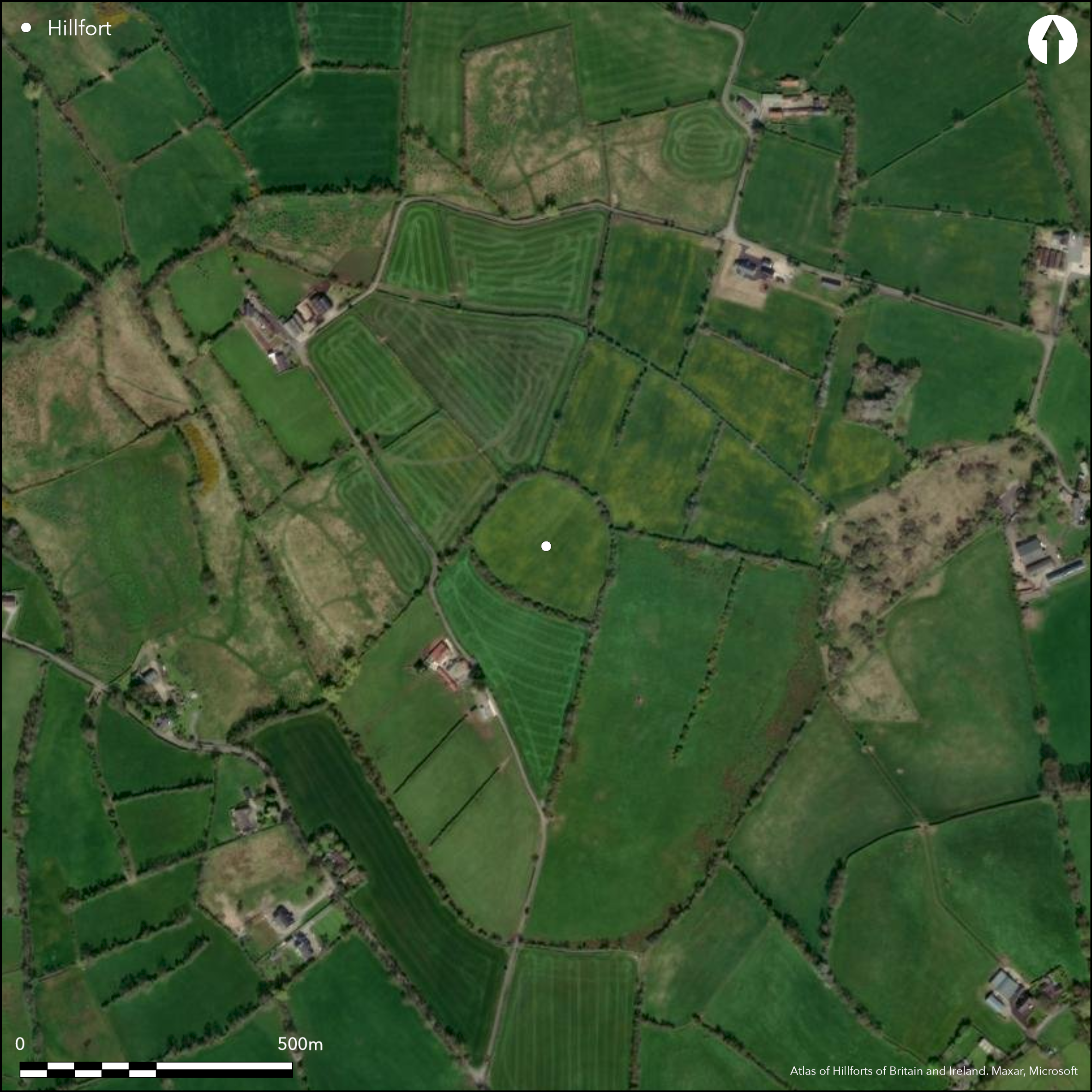
Large, mostly levelled, trivallate hillfort, positioned on a low-rise hill in Tray townland, County Armagh. Inner bank may survive as part of modern field system. Middle and outer enclosing elements visible in aerial photography. These have been confirmed by geophysics and excavation. Excavations by Mallory (1987; 1989; 1990; 1991; 1995; 1996; 1997; 1998; 1999) reveal that all three enclosing elements comprised an internal revetted bank and an external V-shaped ditch 2.3 - 3.2m deep. A portion of a large structure was excavated at the centre of the monument and delimited by a concentration of pits containing bronze and gold-work. These were dated to the Late Bronze Age. A possible entrance in the internal enclosing element (15m in width) has been partially excavated. An entrance gap in the middle enclosing element to the NE was excavated. It comprised a 3m wide entrance flanked on either side by a palisade and is aligned towards the King's Stables, a man-made ritual pool 300m to the NE of Haughey's Fort. This has also been dated to the Late Bronze Age.
Citizen Science: ✗
Reliability of Data: Confirmed
Reliability of Interpretation: Confirmed
X: -747651 Y: 7236636 (EPSG: 3857)
Longitude: -6.71626276829122 Latitude: 54.34954338417637 (EPSG:4326)
Country: Northern Ireland
Current County or Unitary Authority: Armagh
Historic County: Armagh
Current Parish/Community/Council/Townland: Tray
Inner enclosure partially extant. Outer two enclosing elements visible in aerial photography as vegetation mark features.
| Extant | ✓ |
| Cropmark | ✗ |
| Likely Destroyed | ✓ |
Currently in pasture. The land has also been used in arable farming recently.
| Woodland | ✗ |
| Commercial Forestry Plantation | ✗ |
| Parkland | ✗ |
| Pasture (Grazing) | ✓ |
| Arable | ✗ |
| Scrub/Bracken | ✗ |
| Bare Outcrop | ✗ |
| Heather/Moorland | ✗ |
| Heath | ✗ |
| Built-up | ✗ |
| Coastal Grassland | ✗ |
| Other | ✗ |
The hillfort comprises three, somewhat concentric enclosing elements. They surround the domed summit of a low-rise hilltop at 74m OD.
| Contour Fort | ✓ |
| Partial Contour Fort | ✗ |
| Promontory Fort | ✗ |
| Hillslope Fort | ✗ |
| Level Terrain Fort | ✗ |
| Marsh Fort | ✗ |
| Multiple Enclosure Fort | ✓ |
| Hilltop | ✓ |
| Coastal Promontory | ✗ |
| Inland Promontory | ✗ |
| Valley Bottom | ✗ |
| Knoll/Hillock/Outcrop | ✗ |
| Ridge | ✗ |
| Cliff/Plateau-edge/Scarp | ✗ |
| Hillslope | ✗ |
| Lowland | ✗ |
| Spur | ✗ |
Dominant Topographic Feature: Low-rise Hill.
| North | ✗ |
| Northeast | ✗ |
| East | ✗ |
| Southeast | ✗ |
| South | ✗ |
| Southwest | ✗ |
| West | ✗ |
| Northwest | ✗ |
| Level | ✓ |
Altitude: 74.0m
N/A
Eighteen radiocarbon dates have dated the construction and occupation of the hillfort to c. 1381 _ 806 BC (Mallory 1995, 85). A dendro-date of 1166 BC was recovered from water-logged wood at the base of the inner ditch (Ballie and Brown 1991; Ballie and Brown 1998). Artefactual evidence supports the absolute dating of the site. Two radiocarbon dates from an irregular pit returned a date range of 400 _ 200 BC. This pit also contained artefacts that may be typologically dated to the Iron Age. A cup and ring marked stone was found in pit within the interior of the hillfort. Aitchison (1998) has suggested this rock art dates to the Neolithic/Early Bronze Age. The artefact was deposited in a pit radiocarbon dated to the Late Bronze Age (Mallory 1995). Aitchison (1998) suggests that the rock art may have been ritually deposited. Horn (Forthcoming) suggests hillfort start: 1125-1055 cal. BC, hillfort end: 1040-980 cal. BC.
Reliability: A - High
| Pre 1200BC | ✓ |
| 1200BC - 800BC | ✓ |
| 800BC - 400BC | ✗ |
| 400BC - AD50 | ✓ |
| AD50 - AD400 | ✗ |
| AD400 - AD 800 | ✗ |
| Post AD800 | ✗ |
| Unknown | ✗ |
| Pre Hillfort: | None |
| Post Hillfort: | None |
| Artefactual: | Iron Age glass beads (Mallory 1995, 81) |
| Artefactual: | Late Bronze Age coarse-ware pottery (Mallory 1995, 82) |
| Artefactual: | Late Bronze Age glass beads (Mallory 1995, 81) |
| C14: | Eighteen radiocarbon dates have dated the construction and occupation of the hillfort to c. 1381 – 806 BC (Mallory 1995, 85). |
| C14: | Two radiocarbon dates from an irregular pit returned a date range of 400 – 200 BC. |
Excavations by Professor Jim Mallory, Queens University Belfast over several seasons (1987; 1989; 1990; 1991; 1995; 1996; 1997; 1998; 1999). For a summary of these excavations see Mallory (1995). Palaeo-environmental study of the environs of the hillfort undertaken by Weir (1987a; 1987b; 1988; 1994). These excavations have not been published in full. Not identified as a hillfort in any ancient mapping. Inner enclosing element partly depicted as a series of connecting field boundaries.
| Other (1989): | Aerial Survey identified outer enclosing elements (Hartwell 1991) |
| Geophysical Survey (1995): | None |
| Other (None): | Paleo-environmental surveys by Weir 1987a; 1987b; 1988; 1994 |
| Excavation (None): | Excavations by Mallory (1995) |
A possible ritual structure is positioned at centre of the hillfort (Mallory 1995). This comprises three concentric arcs of stakes set outside larger post-holes measuring 25 _ 30m in diameter. This structure delimits pit features that contain charred cereal grain, small traces of gold, bronze, glass, stone artefacts and pottery. The gold was 'almost microscopic' in size. They consisted of small fragments of gold leaf or gold wire. Mallory (1995, 80) has suggests that the gold items might represent industrial waste. A large pit in the interior, approximately 2m in diameter and 2.5m deep, contained Late Bronze Age coarse-ware pottery and animal bone (pig, cattle and red deer). The basal deposit of this pit was waterlogged. Worked and perforated wood was recovered from this context (Mallory 2000b, 7). Struck flint was also recovered from a large pit near the entrance of the inner enclosing element (Mallory 2000a, 3).
None
| None | ✓ |
| Spring | ✗ |
| Stream | ✗ |
| Pool | ✗ |
| Flush | ✗ |
| Well | ✗ |
| Other | ✗ |
None
| No Known Features | ✓ |
| Round Stone Structures | ✗ |
| Rectangular Stone Structures | ✗ |
| Curvilinear Platforms | ✗ |
| Other Roundhouse Evidence | ✗ |
| Pits | ✗ |
| Quarry Hollows | ✗ |
| Other | ✗ |
None
| No Known Excavation | ✗ |
| Pits | ✓ |
| Postholes | ✓ |
| Roundhouses | ✗ |
| Rectangular Structures | ✗ |
| Roads/Tracks | ✗ |
| Quarry Hollows | ✗ |
| Other | ✓ |
| Nothing Found | ✗ |
Geophysical survey was undertaken in 1995 to identify the outer two enclosing elements at the SE, but these results have not been published.
| No Known Geophysics | ✗ |
| Pits | ✗ |
| Roundhouses | ✗ |
| Rectangular Structures | ✗ |
| Roads/Tracks | ✗ |
| Quarry Hollows | ✗ |
| Other | ✓ |
| Nothing Found | ✗ |
None
| No Known Finds | ✗ |
| Pottery | ✓ |
| Metal | ✓ |
| Metalworking | ✓ |
| Human Bones | ✗ |
| Animal Bones | ✓ |
| Lithics | ✓ |
| Environmental | ✓ |
| Other | ✗ |
NO APPARENT FEATURES
| APs Not Checked | ✗ |
| None | ✓ |
| Roundhouses | ✗ |
| Rectangular Structures | ✗ |
| Pits | ✗ |
| Postholes | ✗ |
| Roads/Tracks | ✗ |
| Other | ✗ |
A 3m wide entrance flanked on either side by a palisade in the middle enclosing element is aligned towards the King's Stables (Mallory 1995, 84; Conway 2006). A possible entrance in the inner enclosing feature is at least 15m in width (Mallory 2000b).
| 2: | None |
| 2: | None |
Guard Chambers: ✗
Chevaux de Frise: ✗
| 1. Simple Gap (South east): | Large possible break in the inner enclosing element partially excavated by Mallory (2000b). |
| 2. Simple Gap (North east): | Simple 3m wide gap in middle enclosing element. |
The inner enclosing element is partially preserved in a modern field system. The outer two enclosing features are visible only in aerial photography to the N, E and S. Geophysics and excavation suggests that these formed a complete circuit. Excavation reveals that all three enclosing elements comprise a V-shaped ditch 2.3 _ 3.2m in depth with inner banks probably revetted with stone. The ditch features are water-logged and upon excavation, contained environmental material.
| Area 1: | 1.78ha. |
| Area 2: | 6.38ha. |
| Area 3: | 10.42ha. |
| Total: | 10.42ha. |
Total Footprint Area: 10.42ha.
None
| ✗ | The middle and outer enclosing elements are not visible on available satellite imagery and cannot be measured. The area enclosed by each is not stated in any publications regarding the site. Measurements taken from plan drawings of the site. |
| ✓ | Inner enclosing element is partially extant. The middle and outer enclosing elements are partially visible at the N, E and S in aerial photography. Excavation and geophysical survey indicate that these enclosing features likely formed a complete circuit. |
| NE Quadrant: | 3 |
| SE Quadrant: | 3 |
| SW Quadrant: | 1 |
| NW Quadrant: | 3 |
| Total: | 3 |
| Partial Univallate | ✓ |
| Univallate | ✗ |
| Partial Bivallate | ✗ |
| Bivallate | ✗ |
| Partial Multivallate | ✓ |
| Multivallate | ✗ |
| Unknown | ✗ |
| Partial Univallate | ✗ |
| Univallate | ✓ |
| Partial Bivallate | ✗ |
| Bivallate | ✗ |
| Partial Multivallate | ✗ |
| Multivallate | ✗ |
The bank of the inner enclosing element may be partially incorporated into a modern field system.
| None | ✗ |
| Earthen Bank | ✓ |
| Stone Wall | ✓ |
| Rubble | ✗ |
| Wall-walk | ✗ |
| Evidence of Timber | ✗ |
| Vitrification | ✗ |
| Other Burning | ✗ |
| Palisade | ✗ |
| Counter Scarp Bank | ✗ |
| Berm | ✗ |
| Unfinished | ✗ |
| Other | ✗ |
The in-fill layers of all three ditch sections indicate the presence of internal bank features. Possible stone revetment, particularly in the inner enclosing element.(Mallory 1995, 74).
| None | ✗ |
| Earthen Bank | ✓ |
| Stone Wall | ✗ |
| Murus Duplex | ✗ |
| Timber-framed | ✗ |
| Timber-laced | ✗ |
| Vitrification | ✗ |
| Other Burning | ✗ |
| Palisade | ✗ |
| Counter Scarp Bank | ✗ |
| Berm | ✗ |
| Unfinished | ✗ |
| No Known Excavation | ✗ |
| Other | ✓ |
| ✗ | None |
| ✓ | All three ditches are approximately V-shaped in section and measure 2.3 - 3.2m in depth. Water-logged material from these ditches include the remains of four canines. Two canine skulls are the largest examples found in prehistoric Britain or Ireland (Mallory 1991, 24). Two wooden handles, possibly for axeheads, were found in the inner ditch (Mallory 1991, 23). |
Number of Ditches: 3
| ✗ | None |
Aitchison, N. 1998. Late Bronze Age ritual at Haughey's Fort: the evidence of the deposited cup-and-ring marked stone. Emania, 31-39.
Anderson, R. 1989. Haughey's Fort: analysis of an insect death assemblage. Emania, 37-42.
Ballie, M. and Brown, D. 1991. A dendro-date from Haughey's Fort. Emania, 39-40.
Ballie, M. and Brown, D. 1998. Further evidence confirms the twelfth Century BC dendro-date from the inner ditch of Haughey's Fort. Emania, 45-46.
Boreland, D. 1996. Late Bronze Age pottery from Haughey's Fort. Emania, 21-28.
Conway, M. 2006. Survey and excavation in the Navan environs with «Time Team»: Creeveroe, Haughey's Fort and Ballydoo. Emania, 29-52.
Corlett, C. 2000. Cup-and-rings, and the mapping of Haughey's Fort: a suggestion. Emania, 77-78.
Hall, A. 2000. A puffball from Haughey's Fort, Co. Armagh, Northern Ireland, or the Armagh «apple» unmasked. Emania, 75-76.
Hawthorne, M. 1991. A preliminary analysis of wood remains from Haughey's Fort. Emania, 34-38.
Horn, J. Forthcoming. The dating of hillforts in Britain and Ireland. Unpublished PhD thesis, University of Edinburgh.
Mallory, J. 1988. Trial excavations at Haughey's Fort. Emania, 5-20.
Mallory, J. 1991. Excavations at Haughey's Fort: 1989-1990. Emania, 10-26.
Mallory, J. 1995. Haughey's Fort and the Navan Complex in the Late Bronze Age. In Waddell, J and Shee Twohig, E. Ireland in the Bronze Age. The Stationary Office, Dublin, 73-86.
Mallory, J. 2000a. Haughey's Fort, Tray. I, Bennett. (ed) Excavations 1998. Wordwell, Dublin, 3.
Mallory, J. 2000b. Haughey's Fort, Tray. E, Bair-ad. (ed) Excavations 1999. Wordwell, Dublin, 7.
Mallory, J. and Warner, R. 1988. The date of Haughey's Fort. Emania, 36-40.
Mallory, J., McAlister, J. and Davison, J. 1989. Ditch sediments from Haughey's Fort. Emania, 36.
Mallory, J., Moore, D. and Canning, L. 1996. Excavations at Haughey's Fort 1991 and 1995. Emania, 5-21.
McCormick, F. 1988. Animal bones from Haughey's Fort. Emania, 24-27.
McCormick, F. 1991. The animal bones from Haughey's Fort: second report. Emania, 27-33.
Murphy, E. and McCormick, F. 1996. The faunal remains from the inner ditch of Haughey's Fort: third report: 1991 excavation. Emania, 47-50.
Neill, M. 1996. Haughey's Fort excavation 1991: analysis of wood remains. Emania, 28-39.
Weir, D. and Conway, M. 1988. Haughey's Fort: a preliminary palaeobotanical analysis. Emania, 28-31.
Atlas of Hillforts:
Wikidata:
This work is licensed under CC BY-SA 4.0

 and should be cited as:
Lock, Gary and Ralston, Ian. 2024. Atlas of Hillforts of Britain and Ireland. Available at: https://hillforts.arch.ox.ac.uk
Document Version 1.1