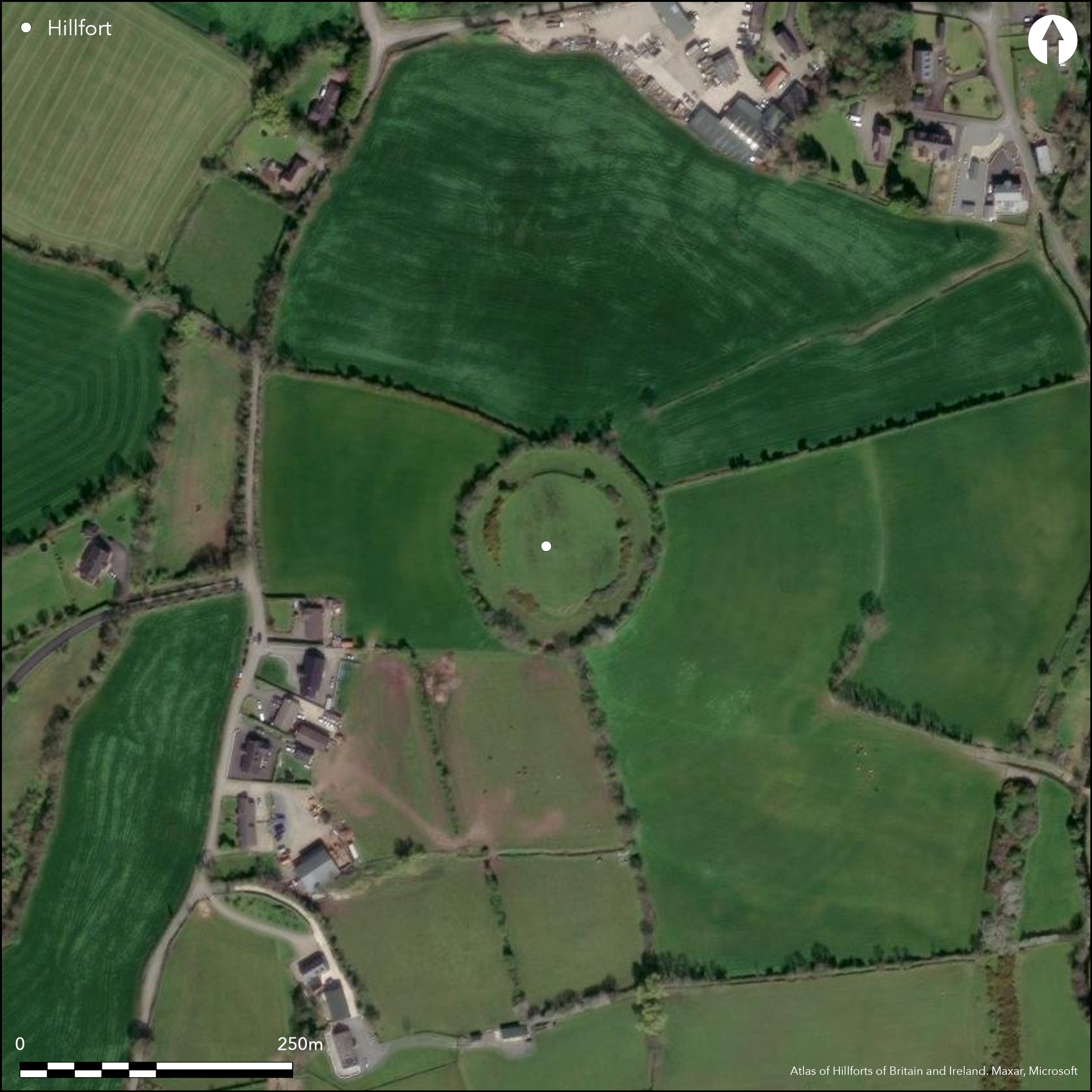
Satellite Imagery
Satellite Imagery
HER: Northern Ireland Sites and Monuments Record ARM016:001 (None)
NMR: ARM 016 (None)
SM: ARM 16:1
NGR: None
X: 685453 Y: 842343 (IRENET95)
Multiple enclosure in commanding position surrounding the domed summit of Lisbanoe Hill, overlooking Callan River and Butler River to immediate E. Bivallate for the entire circuit with a possible original entrance gap on the E of the inner enclosing elements consisting of a simple gap. A break in the outer enclosing elements to the S is probably a modern gap. No evidence for any internal features on the surface. Ramparts survive well throughout the entire circuit. Some tree cover on outer ramparts. Interior under pasture. First map depiction in first edition Ordnance Survey mapping. Earthwork survey by Northern Ireland Environmental Agency in 1990. Excavation 100m to SE of hillfort prior to development. Post-hole with struck flint found in fill (O'Regan 2010).
Citizen Science: ✗
Reliability of Data: Confirmed
Reliability of Interpretation: Confirmed
X: -744330 Y: 7231501 (EPSG: 3857)
Longitude: -6.6864319392393 Latitude: 54.32265020705757 (EPSG:4326)
Country: Northern Ireland
Current County or Unitary Authority: Armagh
Historic County: Armagh
Current Parish/Community/Council/Townland: Lisnadill
None
| Extant | ✓ |
| Cropmark | ✗ |
| Likely Destroyed | ✗ |
None
| Woodland | ✗ |
| Commercial Forestry Plantation | ✗ |
| Parkland | ✗ |
| Pasture (Grazing) | ✓ |
| Arable | ✗ |
| Scrub/Bracken | ✗ |
| Bare Outcrop | ✗ |
| Heather/Moorland | ✗ |
| Heath | ✗ |
| Built-up | ✗ |
| Coastal Grassland | ✗ |
| Other | ✗ |
Multiple enclosure in commanding position surrounding the domed summit of Lisbanoe hill. Panoramic views from summit, overlooking Callan River and Butler River to immediate E.
| Contour Fort | ✓ |
| Partial Contour Fort | ✗ |
| Promontory Fort | ✗ |
| Hillslope Fort | ✗ |
| Level Terrain Fort | ✗ |
| Marsh Fort | ✗ |
| Multiple Enclosure Fort | ✓ |
| Hilltop | ✓ |
| Coastal Promontory | ✗ |
| Inland Promontory | ✗ |
| Valley Bottom | ✗ |
| Knoll/Hillock/Outcrop | ✗ |
| Ridge | ✗ |
| Cliff/Plateau-edge/Scarp | ✗ |
| Hillslope | ✗ |
| Lowland | ✗ |
| Spur | ✗ |
Dominant Topographic Feature: Hilltop.
| North | ✗ |
| Northeast | ✗ |
| East | ✗ |
| Southeast | ✗ |
| South | ✗ |
| Southwest | ✗ |
| West | ✗ |
| Northwest | ✗ |
| Level | ✓ |
Altitude: 72.0m
N/A
No dating evidence.
Reliability: D - None
| Pre 1200BC | ✗ |
| 1200BC - 800BC | ✗ |
| 800BC - 400BC | ✗ |
| 400BC - AD50 | ✗ |
| AD50 - AD400 | ✗ |
| AD400 - AD 800 | ✗ |
| Post AD800 | ✗ |
| Unknown | ✓ |
| Pre Hillfort: | None |
| Post Hillfort: | None |
First map depiction in first edition Ordnance Survey mapping. Earthwork survey by Northern Ireland Environmental Agency in 1990. Excavation 100m to SE of hillfort prior to development. Post-hole with struck flint found in fill (O'Regan 2010).
| 1st Identified Map Depiction (1842): | First edition Ordnance Survey 6 inch mapping. |
| Other (1906): | Second edition Ordnance Survey 25 inch mapping. |
| Earthwork Survey (1990): | Northern Ireland Environmental Agency |
| Excavation (2009): | O'Regan |
No evidence for any internal features on the surface.
None
| None | ✓ |
| Spring | ✗ |
| Stream | ✗ |
| Pool | ✗ |
| Flush | ✗ |
| Well | ✗ |
| Other | ✗ |
None
| No Known Features | ✓ |
| Round Stone Structures | ✗ |
| Rectangular Stone Structures | ✗ |
| Curvilinear Platforms | ✗ |
| Other Roundhouse Evidence | ✗ |
| Pits | ✗ |
| Quarry Hollows | ✗ |
| Other | ✗ |
None
| No Known Excavation | ✓ |
| Pits | ✗ |
| Postholes | ✗ |
| Roundhouses | ✗ |
| Rectangular Structures | ✗ |
| Roads/Tracks | ✗ |
| Quarry Hollows | ✗ |
| Other | ✗ |
| Nothing Found | ✗ |
None
| No Known Geophysics | ✓ |
| Pits | ✗ |
| Roundhouses | ✗ |
| Rectangular Structures | ✗ |
| Roads/Tracks | ✗ |
| Quarry Hollows | ✗ |
| Other | ✗ |
| Nothing Found | ✗ |
None
| No Known Finds | ✓ |
| Pottery | ✗ |
| Metal | ✗ |
| Metalworking | ✗ |
| Human Bones | ✗ |
| Animal Bones | ✗ |
| Lithics | ✗ |
| Environmental | ✗ |
| Other | ✗ |
NO APPARENT FEATURES
| APs Not Checked | ✓ |
| None | ✗ |
| Roundhouses | ✗ |
| Rectangular Structures | ✗ |
| Pits | ✗ |
| Postholes | ✗ |
| Roads/Tracks | ✗ |
| Other | ✗ |
Two breaks in the enclosing elements. A simple break in the outer enclosing elements on the S is probably modern. A simple gap with a ramped causeway is apparent at the E of the inner enclosing element. This may be an original entrance feature.
| 2: | None |
| 2: | None |
Guard Chambers: ✗
Chevaux de Frise: ✗
| 1. Simple Gap (East): | None |
The enclosing elements comprise two widely spaced ramparts separated by an average of 20m. The inner comprises a steep scarp 2m in external height. The outer consists of a scarp 1.7m high with an external ditch feature 3.6m wide and 0.6m deep.
| Area 1: | 0.42ha. |
| Area 2: | 1.04ha. |
| Total: | 1.04ha. |
Total Footprint Area: 1.04ha.
None
| ✗ | None |
| ✓ | None |
| NE Quadrant: | 2 |
| SE Quadrant: | 2 |
| SW Quadrant: | 2 |
| NW Quadrant: | 2 |
| Total: | 2 |
| Partial Univallate | ✗ |
| Univallate | ✗ |
| Partial Bivallate | ✗ |
| Bivallate | ✓ |
| Partial Multivallate | ✗ |
| Multivallate | ✗ |
| Unknown | ✗ |
| Partial Univallate | ✗ |
| Univallate | ✗ |
| Partial Bivallate | ✗ |
| Bivallate | ✗ |
| Partial Multivallate | ✗ |
| Multivallate | ✗ |
None
| None | ✗ |
| Earthen Bank | ✓ |
| Stone Wall | ✗ |
| Rubble | ✗ |
| Wall-walk | ✗ |
| Evidence of Timber | ✗ |
| Vitrification | ✗ |
| Other Burning | ✗ |
| Palisade | ✗ |
| Counter Scarp Bank | ✗ |
| Berm | ✗ |
| Unfinished | ✗ |
| Other | ✗ |
None
| None | ✗ |
| Earthen Bank | ✗ |
| Stone Wall | ✗ |
| Murus Duplex | ✗ |
| Timber-framed | ✗ |
| Timber-laced | ✗ |
| Vitrification | ✗ |
| Other Burning | ✗ |
| Palisade | ✗ |
| Counter Scarp Bank | ✗ |
| Berm | ✗ |
| Unfinished | ✗ |
| No Known Excavation | ✓ |
| Other | ✗ |
| ✗ | None |
| ✓ | Ditch associated with the outer enclosing elements. |
Number of Ditches: 1
| ✗ | None. |
Lett, H. 1884. Report on ancient monuments in the County of Armagh. Journal of Royal Historical and Archaeological Association of Ireland 6, 431-434.
O'Regan, C. 2010. Ballyards Road, Armagh, Co. Armagh: Results of Archaeological Evaluation and Investigation. Unpublished excavation report by Northern Archaeological Consultancy.
Atlas of Hillforts:
Wikidata:
This work is licensed under CC BY-SA 4.0

 and should be cited as:
Lock, Gary and Ralston, Ian. 2024. Atlas of Hillforts of Britain and Ireland. Available at: https://hillforts.arch.ox.ac.uk
Document Version 1.1