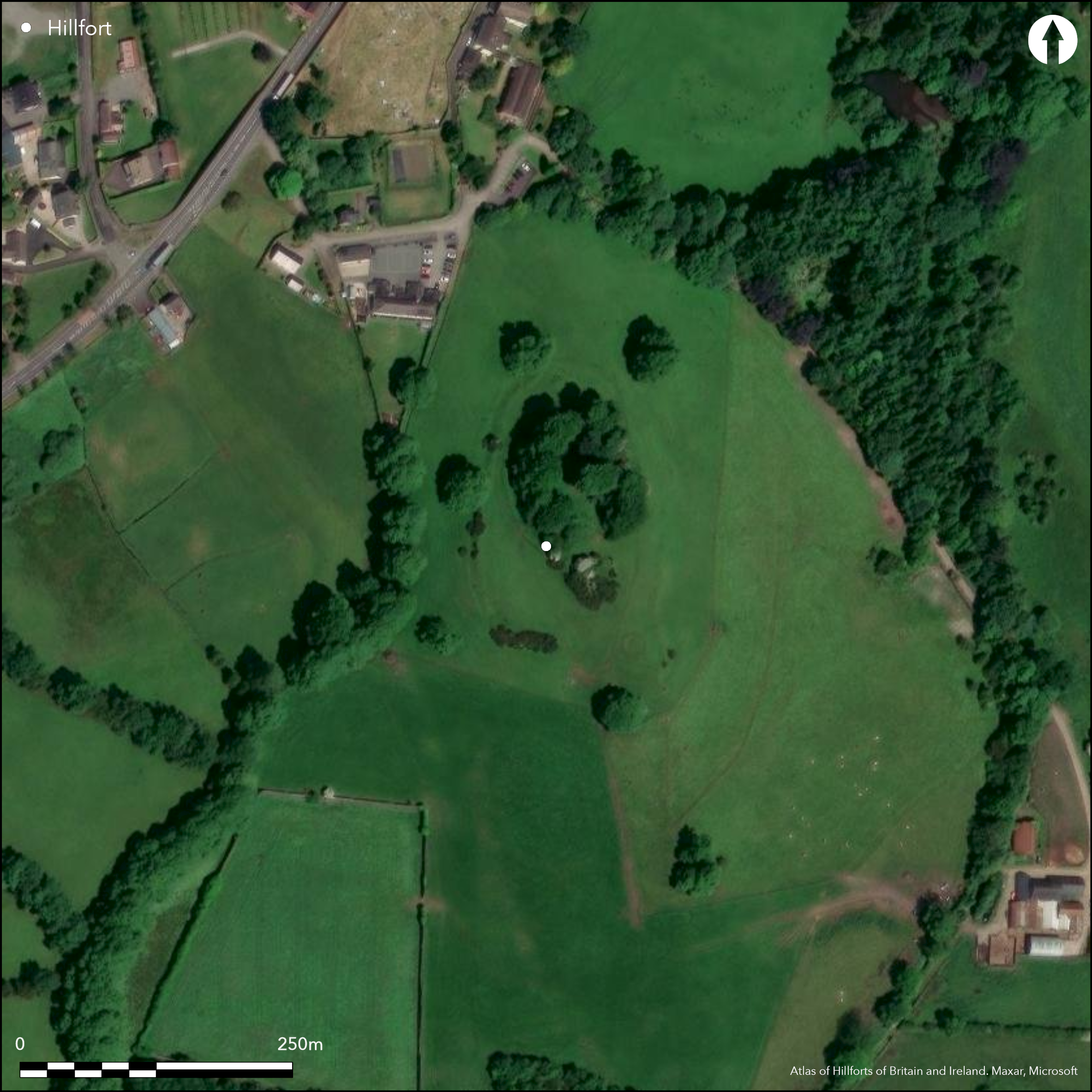
Satellite Imagery
Satellite Imagery
HER: Northern Ireland Sites and Monuments Record TYR058:033 (None)
NMR: TYR 058 (None)
SM: TYR 58:33
NGR: None
X: 653789 Y: 851306 (IRENET95)
Univallate contour fort surrounding the upper part of a steep drumlin (Warner 2009, 510). Sub-rectangular extending to about 1.5ha and enclosed by a bank and external ditch, the bank remaining visible on NE, E, S and SW. Up to eight breaks in the enclosing elements, but it is unknown if any is original. A large ringfort and associated earthworks take up much of the interior. A well-preserved ring barrow is positioned at the NE of the interior. Pits and postholes revealed through excavation. Ramparts survive well at NE, E and SE. Partially levelled at W. Some tree cover in interior and over enclosing elements. Interior under pasture. Excavations by Warner in 1970's. Coarse-ware pottery may also date the univallate hillfort at Clogher, Co. Tyrone to the Late Bronze Age, and more specifically, to the Dowris phase c. 1000 _ 600 BC (Waddell 1998, 270). Radiocarbon dates confirm occupation of the hilltop during this period (Waddell 1998, 270; 277), although there is considerable evidence for later activity. A recent publication by Warner (2009) suggests that the hillfort is Iron Age, largely on the strength of its apparent relationship to a ring-barrow, and despite the author conceding that dating evidence for the earthwork itself is poor and consists of a single ambiguous artefact and an Early Medieval radiocarbon date that dates the primary slippage of the bank material into the ditch (Warner 2009, 510).
Citizen Science: ✗
Reliability of Data: Confirmed
Reliability of Interpretation: Confirmed
X: -798325 Y: 7247712 (EPSG: 3857)
Longitude: -7.1714732129213 Latitude: 54.40749478182711 (EPSG:4326)
Country: Northern Ireland
Current County or Unitary Authority: Tyrone
Historic County: Tyrone
Current Parish/Community/Council/Townland: Clogher
None
| Extant | ✓ |
| Cropmark | ✗ |
| Likely Destroyed | ✗ |
None
| Woodland | ✓ |
| Commercial Forestry Plantation | ✗ |
| Parkland | ✗ |
| Pasture (Grazing) | ✓ |
| Arable | ✗ |
| Scrub/Bracken | ✗ |
| Bare Outcrop | ✗ |
| Heather/Moorland | ✗ |
| Heath | ✗ |
| Built-up | ✗ |
| Coastal Grassland | ✗ |
| Other | ✗ |
Univallate contour fort surrounding the upper part of a steep drumlin (Warner 2009, 510). Panoramic views from the summit. A particular emphasis on views of the wide valley to the N.
| Contour Fort | ✓ |
| Partial Contour Fort | ✗ |
| Promontory Fort | ✗ |
| Hillslope Fort | ✗ |
| Level Terrain Fort | ✗ |
| Marsh Fort | ✗ |
| Multiple Enclosure Fort | ✗ |
| Hilltop | ✓ |
| Coastal Promontory | ✗ |
| Inland Promontory | ✗ |
| Valley Bottom | ✗ |
| Knoll/Hillock/Outcrop | ✗ |
| Ridge | ✗ |
| Cliff/Plateau-edge/Scarp | ✗ |
| Hillslope | ✗ |
| Lowland | ✗ |
| Spur | ✗ |
Dominant Topographic Feature: None
| North | ✗ |
| Northeast | ✗ |
| East | ✗ |
| Southeast | ✗ |
| South | ✗ |
| Southwest | ✗ |
| West | ✗ |
| Northwest | ✗ |
| Level | ✓ |
Altitude: 98.0m
N/A
Coarse-ware pottery may date the univallate hillfort at Clogher, Co. Tyrone to the Late Bronze Age, and more specifically, to the Dowris phase c. 1000 _ 600 BC (Waddell 1998, 270). Radiocarbon dates confirm occupation of the hilltop during this period (Waddell 1998, 270; 277), although there is considerable evidence for later activity. A recent publication by Warner (2009) suggests that the hillfort is Iron Age, despite the author conceding that dating evidence for the earthwork itself is poor and consists of a single ambiguous artefact and an early medieval radiocarbon date for the primary slippage of the bank material into the ditch (Warner 2009, 510). Warner (2009, 512) confusingly states his conclusion, Çunproven and pending further evidence, is that the hillfort at Clogher is very likely to be of Iron Age date. This is in contrast to earlier summary reports that suggest a Late Bronze Age date (Warner 1971; 1972; 1973; 1974; 1975; 1979). Coarse ware pottery Çprobably relates to phase I (Warner 1972), the phase of hillfort construction. This type of pottery, as stated previously, can be firmly dated to the Late Bronze Age. Large pits containing this pottery were revealed at the centre of the hillfort and were Çapparently bounded by a drystone Çcashel-like wall (Warner 1974). Warner suggests that these are possibly Late Bronze Age in date (Warner 1974). Warners summary of excavations between 1977_1979 infer that a radiocarbon date from the old ground surface underneath this central enclosure dates to the Late Bronze Age (Warner 1979). Warner (2009, 508) has more recently argued that the pottery associated with the enclosure is of an unusual Çclub-rim form which can be dated to the later part of the Dowris phase.
Reliability: B - Medium
| Pre 1200BC | ✗ |
| 1200BC - 800BC | ✓ |
| 800BC - 400BC | ✗ |
| 400BC - AD50 | ✗ |
| AD50 - AD400 | ✗ |
| AD400 - AD 800 | ✓ |
| Post AD800 | ✗ |
| Unknown | ✗ |
| Pre Hillfort: | None |
| Post Hillfort: | None |
| Artefactual: | None |
| C14: | None |
Earliest written reference suggesting the site is a hillfort by Evans (1966). Excavations by Warner in 1971; 1972; 1973; 1974; 1975; 1979
| 1st Identified Written Reference (1966): | Evans. |
| Other (1989): | Visit noted in Northern Ireland Sites and Monuments Record |
| Excavation (None): | Warner |
The enclosing element bulges out to incorporate a ring barrow at the ENE. An Early Medieval ringfort is positioned at the centre of hillfort and occupies a considerable portion of the interior.
None
| None | ✓ |
| Spring | ✗ |
| Stream | ✗ |
| Pool | ✗ |
| Flush | ✗ |
| Well | ✗ |
| Other | ✗ |
Ring-barrow and ring-fort
| No Known Features | ✗ |
| Round Stone Structures | ✗ |
| Rectangular Stone Structures | ✗ |
| Curvilinear Platforms | ✗ |
| Other Roundhouse Evidence | ✗ |
| Pits | ✗ |
| Quarry Hollows | ✗ |
| Other | ✓ |
None
| No Known Excavation | ✗ |
| Pits | ✓ |
| Postholes | ✓ |
| Roundhouses | ✗ |
| Rectangular Structures | ✗ |
| Roads/Tracks | ✗ |
| Quarry Hollows | ✗ |
| Other | ✗ |
| Nothing Found | ✗ |
None
| No Known Geophysics | ✓ |
| Pits | ✗ |
| Roundhouses | ✗ |
| Rectangular Structures | ✗ |
| Roads/Tracks | ✗ |
| Quarry Hollows | ✗ |
| Other | ✗ |
| Nothing Found | ✗ |
None
| No Known Finds | ✗ |
| Pottery | ✓ |
| Metal | ✓ |
| Metalworking | ✓ |
| Human Bones | ✗ |
| Animal Bones | ✗ |
| Lithics | ✗ |
| Environmental | ✗ |
| Other | ✗ |
NO APPARENT FEATURES
| APs Not Checked | ✗ |
| None | ✓ |
| Roundhouses | ✗ |
| Rectangular Structures | ✗ |
| Pits | ✗ |
| Postholes | ✗ |
| Roads/Tracks | ✗ |
| Other | ✗ |
Up to eight breaks in the enclosing elements. Five small, simple gaps in the bank apparent at the NE, E and SE. Three wide breaks apparent at the W, WNW and N. It is unknown if any of these gaps are original features.
| 8: | None |
| 2: | None |
Guard Chambers: ✗
Chevaux de Frise: ✗
Sub-rectangular univallate hillfort with bank and external ditch. Bank apparent at the NE, W, SW and S. Levelled for the remainder of its circuit, although excavation has confirmed that the bank and ditch probably formed a complete circuit. The ditch is 2m wide and 1m deep (Warner 2009, 510). Excavation revealed that the ditch may have comprised a much wider and shallower feature, 20m wide and 2m deep (Warner 2009, 510).
| Area 1: | 1.5ha. |
| Total: | 1.5ha. |
Total Footprint Area: 1.6ha.
None
| ✗ | In addition, excavation of the perimeter of the ring-fort revealed evidence of a stone-facd rampart with transverse timber beams |
| ✓ | None |
| NE Quadrant: | 1 |
| SE Quadrant: | 1 |
| SW Quadrant: | 1 |
| NW Quadrant: | 1 |
| Total: | 1 |
| Partial Univallate | ✗ |
| Univallate | ✓ |
| Partial Bivallate | ✗ |
| Bivallate | ✗ |
| Partial Multivallate | ✗ |
| Multivallate | ✗ |
| Unknown | ✗ |
| Partial Univallate | ✗ |
| Univallate | ✗ |
| Partial Bivallate | ✗ |
| Bivallate | ✗ |
| Partial Multivallate | ✗ |
| Multivallate | ✗ |
None
| None | ✗ |
| Earthen Bank | ✓ |
| Stone Wall | ✗ |
| Rubble | ✗ |
| Wall-walk | ✗ |
| Evidence of Timber | ✗ |
| Vitrification | ✗ |
| Other Burning | ✗ |
| Palisade | ✗ |
| Counter Scarp Bank | ✗ |
| Berm | ✗ |
| Unfinished | ✗ |
| Other | ✗ |
Bank and ditch
| None | ✗ |
| Earthen Bank | ✓ |
| Stone Wall | ✗ |
| Murus Duplex | ✗ |
| Timber-framed | ✗ |
| Timber-laced | ✗ |
| Vitrification | ✗ |
| Other Burning | ✗ |
| Palisade | ✗ |
| Counter Scarp Bank | ✗ |
| Berm | ✗ |
| Unfinished | ✗ |
| No Known Excavation | ✗ |
| Other | ✓ |
| ✗ | None |
| ✗ | External ditch. |
Number of Ditches: 1
| ✗ | None. |
Evens, E. 1966. Prehistoric and Early Christian Ireland: a Guide. Batsford, London.
Waddell, J. 1998. The Prehistoric Archaeology of Ireland. Wordwell, Wicklow.
Warner, R. 1971. Archaeological excavations at Clogher, Co. Tyrone, 1971. https://www.excavations.ie/Pages/Details.php?Year=&County=Meath&id=5473.
Warner, R. 1972. Archaeological excavations at Clogher, Co. Tyrone, 1972, https://www.excavations.ie/Pages/Details.php?Year=&County=Tyrone&id=5527.
Warner, R. 1973. Archaeological excavations at Clogher, Co. Tyrone, 1973, https://www.excavations.ie/Pages/Details.php?Year=&County=Tyrone&id=5592.
Warner, R. 1974. Archaeological excavations at Clogher, Co. Tyrone, 1974, https://www.excavations.ie/Pages/Details.php?Year=&County=Tyrone&id=5572.
Warner, R. 1975. Archaeological excavations at Clogher, Co. Tyrone, 1975, https://www.excavations.ie/Pages/Details.php?Year=&County=Tyrone&id=5631.
Warner, R. 1979. Archaeological excavations at Clogher, Co. Tyrone, 1979, https://www.excavations.ie/Pages/Details.php?Year=&County=Tyrone&id=5739.
Warner, R 2009. Clogher in late prehistory. In G Cooney, K Becker, J Coles, M Ryan and S Sievers (eds), Relics of Old Decency: Archaeological Studies in Later Prehistory. Wordwell, Dublin. 507-518.
Atlas of Hillforts:
Wikidata:
This work is licensed under CC BY-SA 4.0

 and should be cited as:
Lock, Gary and Ralston, Ian. 2024. Atlas of Hillforts of Britain and Ireland. Available at: https://hillforts.arch.ox.ac.uk
Document Version 1.1