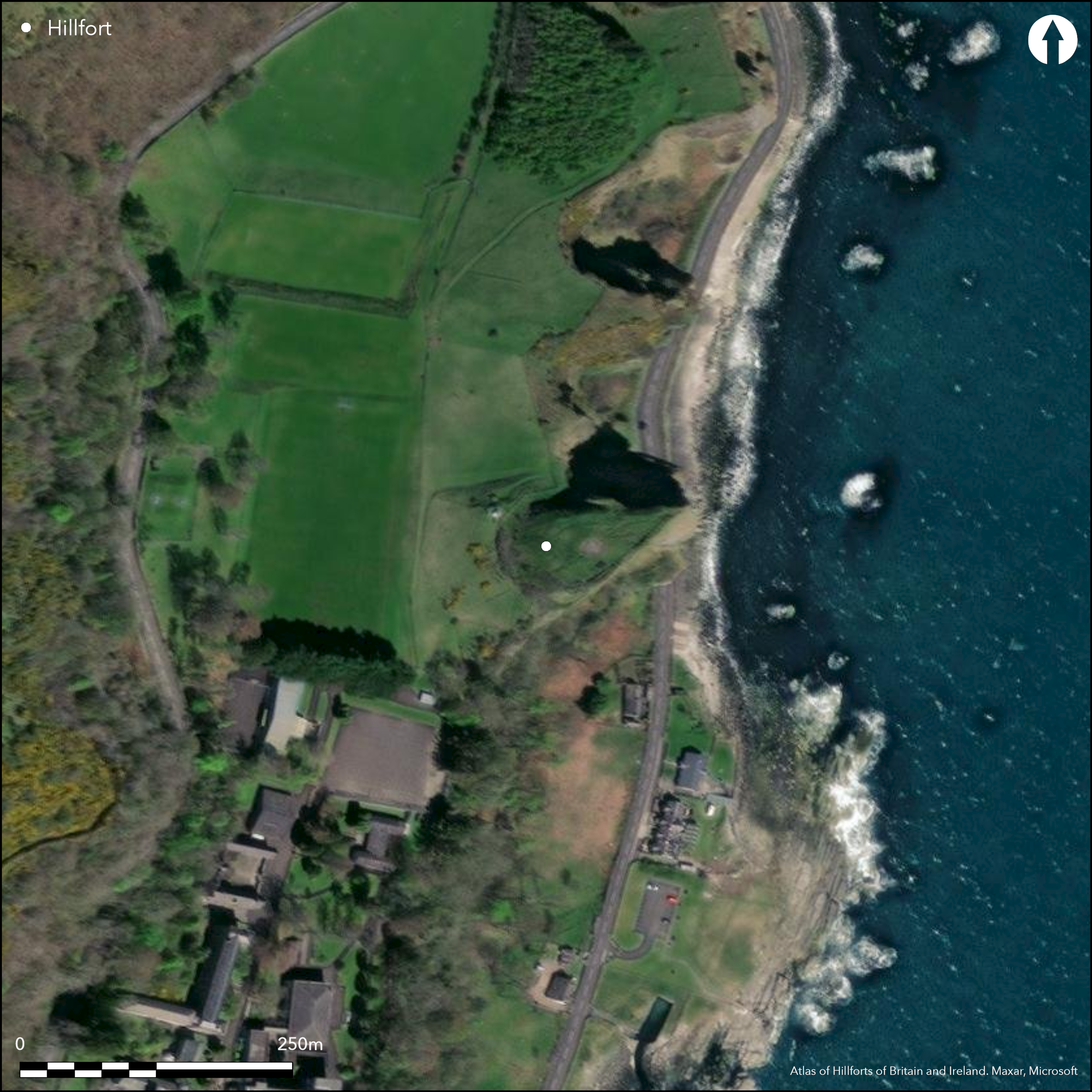
Satellite Imagery
Satellite Imagery
HER: Northern Ireland Sites and Monuments Record ANT020:003 (None)
NMR: ANT 020 (None)
SM: ANT 20:3
NGR: None
X: 730021 Y: 923935 (IRENET95)
This coastal promontory fort, depicted as a hachured enclosure on the first edition (1839) OS six-inch map as, is situated 27km NE of Ballymena on the leading edge of a terrace below the higher rocky cliffs to the W. It has expansive views to the S along the coast and the sea to the E, forming part of the coastal escarpment immediately above the shore. The promontory is forms a steep sided hillock rising c. 9m above the bottom of the ditch and its relatively level triangular interior measures 32.5m N/S by 39m E/W. Bedrock is exposed along its flanks and the ditch that has been drawn in an arc from the cliff-edge on the N round the W to the SW measures c. 4m wide and is c. 1.5m deep externally. There is also an external bank, though this has been heavily degraded. On the W a narrow causeway 1.3m wide crosses the ditch, and a narrow path leads to the top of the promontory, which is enclosed by a bank standing up to 1.1m high above the interior. There are no recorded hut-sites within the interior where there has been much modern disturbance, mostly in the construction of a reservoir on top of the fort (now out of use). A large shrine is set on the outer bank at W and the top of the outer bank seems to be used as a trackway and as a stand from viewing matches on the football pitch to the W.
Citizen Science: ✗
Reliability of Data: Confirmed
Reliability of Interpretation: Confirmed
X: -664065 Y: 7370778 (EPSG: 3857)
Longitude: -5.965400247232573 Latitude: 55.04589375286466 (EPSG:4326)
Country: Northern Ireland
Current County or Unitary Authority: Antrim
Historic County: Antrim
Current Parish/Community/Council/Townland: Gallboly Lower
None
| Extant | ✓ |
| Cropmark | ✗ |
| Likely Destroyed | ✗ |
None
| Woodland | ✗ |
| Commercial Forestry Plantation | ✗ |
| Parkland | ✓ |
| Pasture (Grazing) | ✗ |
| Arable | ✗ |
| Scrub/Bracken | ✓ |
| Bare Outcrop | ✗ |
| Heather/Moorland | ✗ |
| Heath | ✗ |
| Built-up | ✗ |
| Coastal Grassland | ✗ |
| Other | ✗ |
None
| Contour Fort | ✗ |
| Partial Contour Fort | ✗ |
| Promontory Fort | ✓ |
| Hillslope Fort | ✗ |
| Level Terrain Fort | ✗ |
| Marsh Fort | ✗ |
| Multiple Enclosure Fort | ✗ |
| Hilltop | ✗ |
| Coastal Promontory | ✓ |
| Inland Promontory | ✗ |
| Valley Bottom | ✗ |
| Knoll/Hillock/Outcrop | ✗ |
| Ridge | ✗ |
| Cliff/Plateau-edge/Scarp | ✗ |
| Hillslope | ✗ |
| Lowland | ✗ |
| Spur | ✗ |
Dominant Topographic Feature: None
| North | ✗ |
| Northeast | ✗ |
| East | ✗ |
| Southeast | ✗ |
| South | ✗ |
| Southwest | ✗ |
| West | ✗ |
| Northwest | ✗ |
| Level | ✓ |
Altitude: 50.0m
N/A
There is no dating available for the site
Reliability: D - None
| Pre 1200BC | ✗ |
| 1200BC - 800BC | ✗ |
| 800BC - 400BC | ✗ |
| 400BC - AD50 | ✗ |
| AD50 - AD400 | ✗ |
| AD400 - AD 800 | ✗ |
| Post AD800 | ✗ |
| Unknown | ✓ |
| Pre Hillfort: | None |
| Post Hillfort: | Modern resevoir |
Depicted as a hachured enclosure on the first edition (1839) OS six-inch map. Described by O'Laverty (1887, 553) as Dunmall (D–n Maul-Bald fort). Surveyed by the Archaeological Survey of Northern Ireland in 1992.
| 1st Identified Map Depiction (1839): | OS six-inch map |
| 1st Identified Written Reference (1887): | O'Laverty (Vol 4) |
| Earthwork Survey (1992): | Archaeological Survey of Northern Ireland |
| Other (2000): | Description Northern Ireland Sites and Monuments Record |
Apart from the modern resevoir in the centre of the promontory, there are no other recorded internal features.
None
| None | ✓ |
| Spring | ✗ |
| Stream | ✗ |
| Pool | ✗ |
| Flush | ✗ |
| Well | ✗ |
| Other | ✗ |
Resevoir
| No Known Features | ✗ |
| Round Stone Structures | ✗ |
| Rectangular Stone Structures | ✗ |
| Curvilinear Platforms | ✗ |
| Other Roundhouse Evidence | ✗ |
| Pits | ✗ |
| Quarry Hollows | ✗ |
| Other | ✓ |
None
| No Known Excavation | ✓ |
| Pits | ✗ |
| Postholes | ✗ |
| Roundhouses | ✗ |
| Rectangular Structures | ✗ |
| Roads/Tracks | ✗ |
| Quarry Hollows | ✗ |
| Other | ✗ |
| Nothing Found | ✗ |
None
| No Known Geophysics | ✓ |
| Pits | ✗ |
| Roundhouses | ✗ |
| Rectangular Structures | ✗ |
| Roads/Tracks | ✗ |
| Quarry Hollows | ✗ |
| Other | ✗ |
| Nothing Found | ✗ |
None
| No Known Finds | ✓ |
| Pottery | ✗ |
| Metal | ✗ |
| Metalworking | ✗ |
| Human Bones | ✗ |
| Animal Bones | ✗ |
| Lithics | ✗ |
| Environmental | ✗ |
| Other | ✗ |
Resevoir
| APs Not Checked | ✗ |
| None | ✗ |
| Roundhouses | ✗ |
| Rectangular Structures | ✗ |
| Pits | ✗ |
| Postholes | ✗ |
| Roads/Tracks | ✗ |
| Other | ✓ |
A narrow causeway crosses the ditch to the W. It measures 1.3m wide.
| 1: | None |
| 2: | None |
Guard Chambers: ✗
Chevaux de Frise: ✗
| 1. Simple Gap (West): | At W is a narrow causeway 1.3m wide, which runs across the ditch, and a narrow path leads to the top. |
The promontory is defined by steep slopes around its flanks and rises c. 9m above the bottom of the ditch drawn across its neck on the W. The top measures 32.5m N-S by 39m E-W and is enclosed by a bank up to 1.1m in internal height. The ditch measures c. 4m wide and is c. 1.5m deep externally and there is also a heavily denuded external bank.
| Area 1: | 0.08ha. |
| Total: | 0.08ha. |
Total Footprint Area: 0.23ha.
None
| ✗ | None |
| ✓ | None |
| NE Quadrant: | 1 |
| SE Quadrant: | 1 |
| SW Quadrant: | 1 |
| NW Quadrant: | 1 |
| Total: | 1 |
| Partial Univallate | ✗ |
| Univallate | ✓ |
| Partial Bivallate | ✗ |
| Bivallate | ✗ |
| Partial Multivallate | ✗ |
| Multivallate | ✗ |
| Unknown | ✗ |
| Partial Univallate | ✗ |
| Univallate | ✗ |
| Partial Bivallate | ✗ |
| Bivallate | ✗ |
| Partial Multivallate | ✗ |
| Multivallate | ✗ |
None
| None | ✗ |
| Earthen Bank | ✓ |
| Stone Wall | ✗ |
| Rubble | ✗ |
| Wall-walk | ✗ |
| Evidence of Timber | ✗ |
| Vitrification | ✗ |
| Other Burning | ✗ |
| Palisade | ✗ |
| Counter Scarp Bank | ✗ |
| Berm | ✗ |
| Unfinished | ✗ |
| Other | ✗ |
None
| None | ✗ |
| Earthen Bank | ✗ |
| Stone Wall | ✗ |
| Murus Duplex | ✗ |
| Timber-framed | ✗ |
| Timber-laced | ✗ |
| Vitrification | ✗ |
| Other Burning | ✗ |
| Palisade | ✗ |
| Counter Scarp Bank | ✗ |
| Berm | ✗ |
| Unfinished | ✗ |
| No Known Excavation | ✓ |
| Other | ✗ |
| ✗ | None |
| ✓ | None |
Number of Ditches: 1
| ✗ | None |
www.ni-environment.co.uk
Lawlor, H.C. 1939. Mote and mote-and-bailey castles in de Courcy's principality of Ulster. Ulster Journal of Archaeology 2, 46-54.
OS memoirs of Ardclinis 1832, Box 2, 11, 1, 6
Atlas of Hillforts:
Wikidata:
This work is licensed under CC BY-SA 4.0

 and should be cited as:
Lock, Gary and Ralston, Ian. 2024. Atlas of Hillforts of Britain and Ireland. Available at: https://hillforts.arch.ox.ac.uk
Document Version 1.1