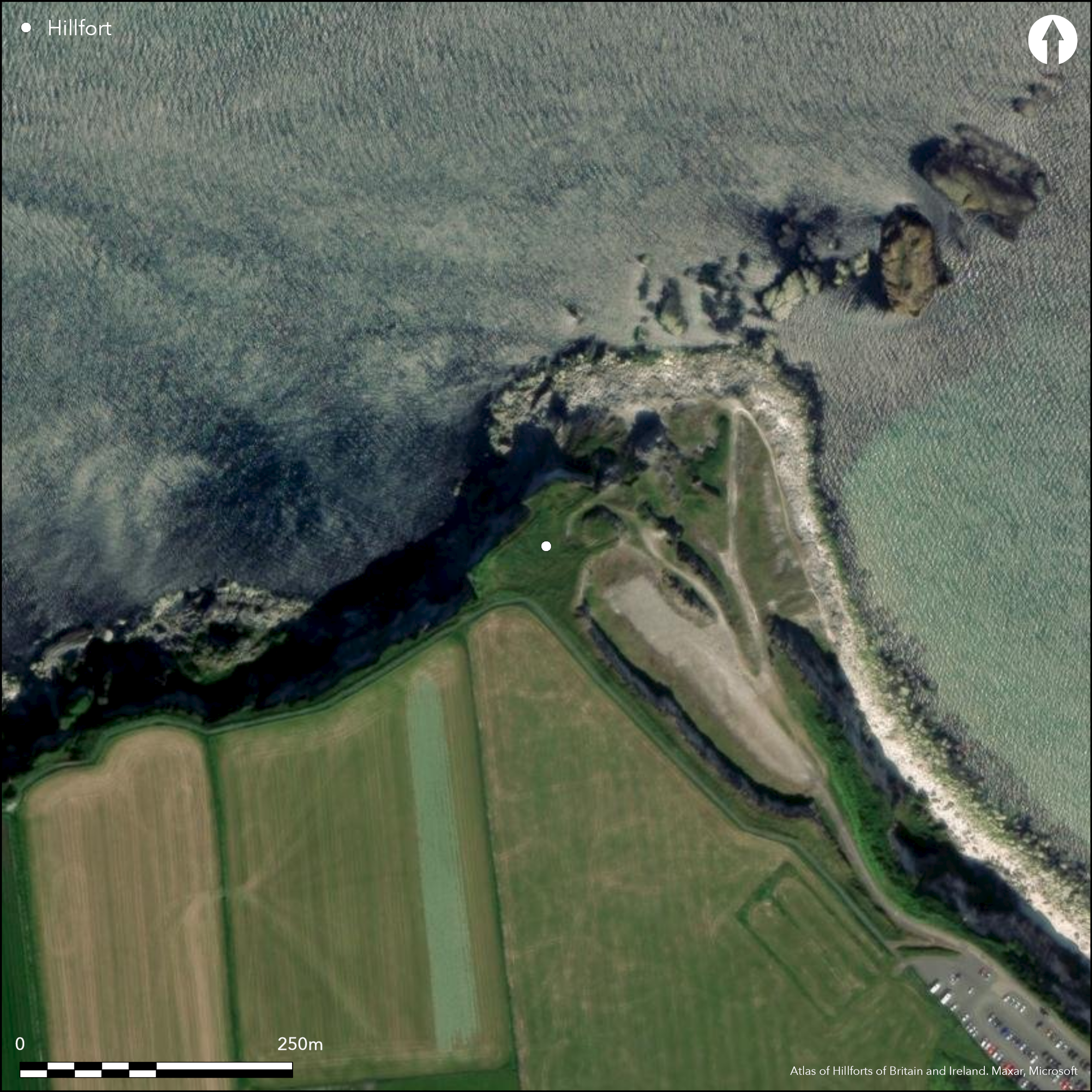
Satellite Imagery
Satellite Imagery
HER: Northern Ireland Sites and Monuments Record ANT004:005 (None)
NMR: ANT 004 (None)
SM: None
NGR: None
X: 704769 Y: 945081 (IRENET95)
This promontory fort, depicted as a circular enclosure on the first edition (1839) OS six-inch map, is situated on 'Larry Bane Head' c. 1km N of Ballintotty village, Co. Antrim. It has been largely destroyed by quarrying, but projects N between Boheesshane Bay and Larrybane Bay. The promontory is composed of chalk, overlooking Sheep Island with extensive views of Rathlin Island to the NE and good views up and down the coastline to the NW and SE respectively. An exposed site, the promontory falls away sheer down the cliffs some 40m to the sea on the W and N, while on the SE it is no bounded by the face of the quarry which resumed at the site during the 1950s. Few definite features remain that correspond to Proudfoot's plan drawn in 1960-1, which on the SW shows a curving ditch and an internal stone faced bank cutting off the promontory from the mainland. A section of linear grass-covered stone bank 8m long, 4.5m wide and 0.8m high at SE is possibly a remnant of the original rampart. Outside this are the remains of a possible ditch, while to the W are a further length of a possible ditch at the W margin of the promontory; the latter is c. 10m in length, c. 4m wide and 1m in depth. It was first excavated by Gordon Childe in 1935, who, working in the W part of the interior, was able to distinguish "over a comparatively small area" at least four phases of occupation "on and in, as well as under" the rampart debris (Proundfoot and Wilson 1960-1, 93). The site was later excavated in the 1960s by Proudfoot and Wilson who cut sections revealing the stone-faced rampart and external ditch on the landward side. The rampart was composed of large basalt boulders which rested on blue clay. The inner and outer stone facing consisted of flat stones up to 6 courses high in places. A large quantity of small chalk stones were found in layers that sloped up to the face of the bank, which Proudfoot and Wilson suggest must have been originally piled on top of stone rampart (1960-1, 95). The ditch had been cut through the boulder clay and underlying chalk bedrock. In 1838 Fagan recorded the ditch as '23 feet wide, and the top of the rampart stood 8 to 12 ft. above its bottom'. Within the interior of the site, a number of hearths were found but no building outlines, suggesting to Proudfoot and Wilson that houses were composed of turf (ibid., 105). There were 4 distinct levels of occupation, dating from 700-900 AD and finds included a glass bracelet, a bronze tinned bracelet, large amounts of bones & sherds of pottery and an amber bead.
Citizen Science: ✗
Reliability of Data: Confirmed
Reliability of Interpretation: Confirmed
X: -707162 Y: 7408928 (EPSG: 3857)
Longitude: -6.352540164895647 Latitude: 55.24175742587329 (EPSG:4326)
Country: Northern Ireland
Current County or Unitary Authority: Antrim
Historic County: Antrim
Current Parish/Community/Council/Townland: Larrybane
This promotory fort has been almost completely destroyed by quarrying and there are now few definite visible remains.
| Extant | ✗ |
| Cropmark | ✗ |
| Likely Destroyed | ✓ |
None
| Woodland | ✗ |
| Commercial Forestry Plantation | ✗ |
| Parkland | ✗ |
| Pasture (Grazing) | ✓ |
| Arable | ✗ |
| Scrub/Bracken | ✗ |
| Bare Outcrop | ✗ |
| Heather/Moorland | ✗ |
| Heath | ✗ |
| Built-up | ✗ |
| Coastal Grassland | ✓ |
| Other | ✗ |
This coastal promontory can be described as a roughly circular headland, largely destroyed that projects N between Boheesshane Bay and Larrybane Bay. An exposed site, the promontory falls away sheer down the cliffs some 40m to the sea on the W, N and E sides. It has been almost completely destroyed by quarrying but was once defended to the S by a curving stone faced bank and external ditch. It sites at an altitude of 21m OD.
| Contour Fort | ✗ |
| Partial Contour Fort | ✗ |
| Promontory Fort | ✓ |
| Hillslope Fort | ✗ |
| Level Terrain Fort | ✗ |
| Marsh Fort | ✗ |
| Multiple Enclosure Fort | ✗ |
| Hilltop | ✗ |
| Coastal Promontory | ✓ |
| Inland Promontory | ✗ |
| Valley Bottom | ✗ |
| Knoll/Hillock/Outcrop | ✗ |
| Ridge | ✗ |
| Cliff/Plateau-edge/Scarp | ✗ |
| Hillslope | ✗ |
| Lowland | ✗ |
| Spur | ✗ |
Dominant Topographic Feature: N-facing promontory
| North | ✓ |
| Northeast | ✗ |
| East | ✗ |
| Southeast | ✗ |
| South | ✗ |
| Southwest | ✗ |
| West | ✗ |
| Northwest | ✗ |
| Level | ✗ |
Altitude: 21.0m
N/A
There were 4 distinct levels of occupation, dating from 700-900 AD and finds included a glass bracelet, a bronze tinned bracelet, large amounts of bones & sherds of pottery and an amber bead.
Reliability: B - Medium
| Pre 1200BC | ✗ |
| 1200BC - 800BC | ✗ |
| 800BC - 400BC | ✗ |
| 400BC - AD50 | ✗ |
| AD50 - AD400 | ✗ |
| AD400 - AD 800 | ✓ |
| Post AD800 | ✗ |
| Unknown | ✗ |
| Pre Hillfort: | None |
| Post Hillfort: | None |
| Artefactual: | None |
The site is depicted as a hachured promontory on the first edition OS six-inch map (1839). Defences described by Fagan in the parish memoirs (1839). The interior of the site was partially excavated by Gordon Childe in 1935 who discovered a number of hearths, pottery and metal objects. Later excavated by Proudfoot and Wilson who confirmed that the promontory was defended by a stone rampart and outer ditch although evidence for internal structures was lacking in spite of the many artefact finds. Surveyed by the Archaeological Survey of Northern Ireland in 1994 who noted considerable damage from later quarrying at the site.
| 1st Identified Map Depiction (1839): | OS six-inch mapping |
| 1st Identified Written Reference (1839): | Fagan (Parish Memoirs) |
| Excavation (1935): | Gordon Childe |
| Other (1994): | Description Northern Ireland Sites and Monuments Record |
| Excavation (None): | Proudfoot and Wilson |
Within the interior of the site, a number of hearths were found but no building outlines suggesting to Proudfoot and Wilson that houses were composed of turf. Some house floors were roughly cobbled and paved and the excavators note that one particular example was rectangular. The three hearths were associated with charcoal and pottery finds.
None
| None | ✓ |
| Spring | ✗ |
| Stream | ✗ |
| Pool | ✗ |
| Flush | ✗ |
| Well | ✗ |
| Other | ✗ |
Modern quarries
| No Known Features | ✗ |
| Round Stone Structures | ✗ |
| Rectangular Stone Structures | ✗ |
| Curvilinear Platforms | ✗ |
| Other Roundhouse Evidence | ✗ |
| Pits | ✗ |
| Quarry Hollows | ✗ |
| Other | ✓ |
Hearths and occupation floors
| No Known Excavation | ✗ |
| Pits | ✗ |
| Postholes | ✗ |
| Roundhouses | ✗ |
| Rectangular Structures | ✓ |
| Roads/Tracks | ✗ |
| Quarry Hollows | ✗ |
| Other | ✓ |
| Nothing Found | ✗ |
None
| No Known Geophysics | ✓ |
| Pits | ✗ |
| Roundhouses | ✗ |
| Rectangular Structures | ✗ |
| Roads/Tracks | ✗ |
| Quarry Hollows | ✗ |
| Other | ✗ |
| Nothing Found | ✗ |
None
| No Known Finds | ✗ |
| Pottery | ✓ |
| Metal | ✓ |
| Metalworking | ✓ |
| Human Bones | ✗ |
| Animal Bones | ✓ |
| Lithics | ✓ |
| Environmental | ✓ |
| Other | ✗ |
NO APPARENT FEATURES
| APs Not Checked | ✓ |
| None | ✗ |
| Roundhouses | ✗ |
| Rectangular Structures | ✗ |
| Pits | ✗ |
| Postholes | ✗ |
| Roads/Tracks | ✗ |
| Other | ✗ |
Childe argued that an entrance existed on the W due to the bank having a more complicated structure at this end, but there is no indication archaeologically that an entrance existed at this location. Furthermore, none of the OS six-inch maps record an entrance. Thomas Fagans inspection of the site in 1838 revealed no such evidence.
| 0: | None |
| 2: | None |
Guard Chambers: ✗
Chevaux de Frise: ✗
Although only traces of the defences exist today due to extensive quarrying, excavation in the 1960's revealed that the promontory was once defended by a curving stone rampart composed of large basalt boulders which rested on blue clay and faced inside and out with up to 6 courses of flat stones. A large quantity of small chalk stones were found in layers that sloped up to the face of the bank which Proudfoot and Wilson suggest must have been piled on top of the stone rampart (1960-1, 95). The ditch had been cut through the boulder clay and underlying chalk bedrock. In 1838 Fagan recorded the ditch as '23f eet wide, and the top of the rampart stood 8 to 12 ft. above its bottom'.
| Area 1: | Noneha. |
| Total: | Noneha. |
Total Footprint Area: 0.46ha.
None
| ✗ | None |
| ✗ | None |
| NE Quadrant: | 0 |
| SE Quadrant: | 0 |
| SW Quadrant: | 1 |
| NW Quadrant: | 0 |
| Total: | 1 |
| Partial Univallate | ✓ |
| Univallate | ✗ |
| Partial Bivallate | ✗ |
| Bivallate | ✗ |
| Partial Multivallate | ✗ |
| Multivallate | ✗ |
| Unknown | ✗ |
| Partial Univallate | ✗ |
| Univallate | ✗ |
| Partial Bivallate | ✗ |
| Bivallate | ✗ |
| Partial Multivallate | ✗ |
| Multivallate | ✗ |
Some evidence of a grass-covered stone wall exist but the majority of the rampart has been destroyed by quarrying
| None | ✗ |
| Earthen Bank | ✗ |
| Stone Wall | ✓ |
| Rubble | ✗ |
| Wall-walk | ✗ |
| Evidence of Timber | ✗ |
| Vitrification | ✗ |
| Other Burning | ✗ |
| Palisade | ✗ |
| Counter Scarp Bank | ✗ |
| Berm | ✗ |
| Unfinished | ✗ |
| Other | ✗ |
Wall and ditch
| None | ✗ |
| Earthen Bank | ✗ |
| Stone Wall | ✓ |
| Murus Duplex | ✗ |
| Timber-framed | ✗ |
| Timber-laced | ✗ |
| Vitrification | ✗ |
| Other Burning | ✗ |
| Palisade | ✗ |
| Counter Scarp Bank | ✗ |
| Berm | ✗ |
| Unfinished | ✗ |
| No Known Excavation | ✗ |
| Other | ✓ |
| ✗ | None |
| ✓ | None |
Number of Ditches: 1
| ✗ | None |
www.ni-environment.co.uk
Childe, V.G 1936. A promontory fort on the Antrim Coast. Antiquaries Journal 16, 179-198.
OS memoirs of the parish of Ballintoy, Fagan 1838, Box 3, 2, 2, 63-64
Proudfoot V.B and Wilson, B.C.S 1961. Further excavations at Larrybane Promontory Fort, Co. Antrim. Ulster Journal of Archaeology 24-25, 91-115.
Atlas of Hillforts:
Wikidata:
This work is licensed under CC BY-SA 4.0

 and should be cited as:
Lock, Gary and Ralston, Ian. 2024. Atlas of Hillforts of Britain and Ireland. Available at: https://hillforts.arch.ox.ac.uk
Document Version 1.1