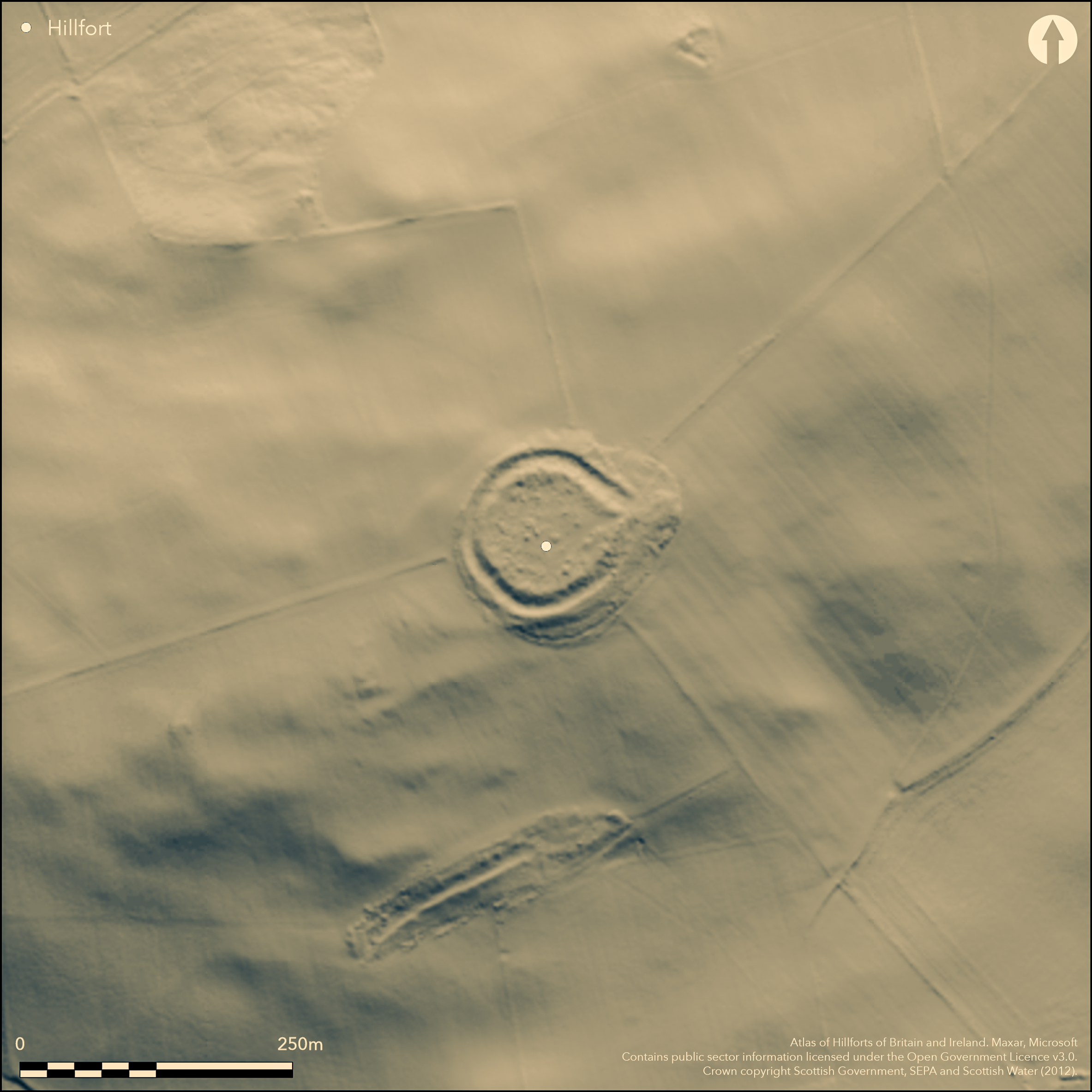
LiDAR 1m DTM Hillshade
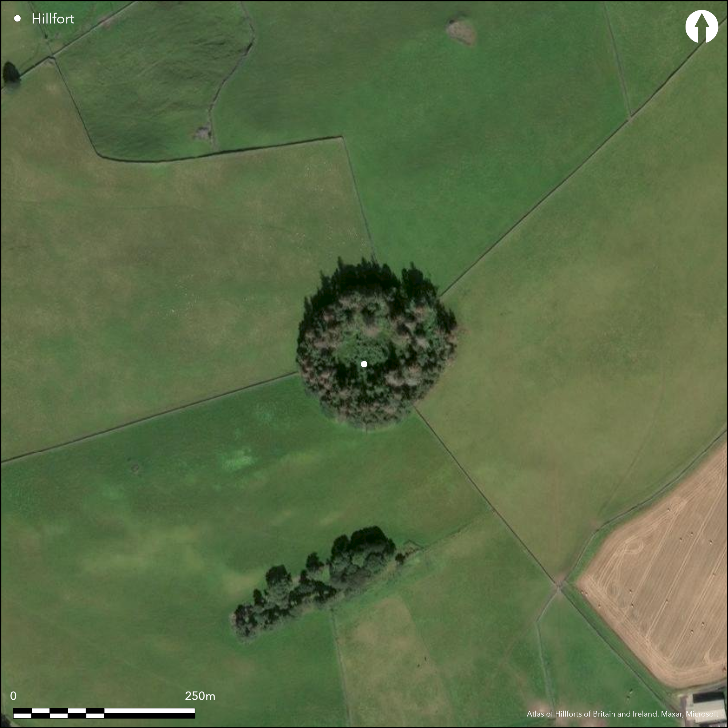
Satellite Imagery
LiDAR 1m DTM Hillshade
Satellite Imagery
Scroll left/right to view further images.
HER: Scottish Borders 54448 (None)
NMR: NT 43 SE 7 (54448)
SM: 2119
NGR: NT 4802 3270
X: 348020 Y: 632700 (OSGB36)
This fort is situated immediately E of the highest point of Rink Hill, occupying a shoulder position on the SE of the broader summit area overlooking the confluence of the River Tweed and the Ettrick Water. The main defences comprise a massively constructed inner wall encircled by a ditch with an outer rampart, which enclose a slightly oval area measuring about 65m from E to W by 55m transversely (0.28ha). The inner wall, which is up to 4.2m in thickness, is reduced to a massive mound of rubble about 1.8m in internal height, but the line of the outer face is intermittently visible round the whole circuit, and the inner face at one point on the NE; in 1950 RCAHMS investigators also identified on the S a second line of outer facing in the core, suggesting that the wall represented several periods of construction. Apart from a short length of wall overlying rubble of the inner wall on the N, which is probably associated with the foundations of three rectangular buildings outside the entrance on the E, the interior is featureless. The foundations outside the entrance were misinterpreted by the first OS surveyors as elements of the outer defences (Selkirk 1863, sheet 8.9), but they also identified what is almost certainly an earlier enclosure on the site, extending in a wider arc around the W flank, though it is now largely ploughed out and known only from a parchmark about 2m broad on aerial photographs. In 1950 the RCAHMS investigators suggested that its line took up the scarp overlain by the southern of the foundations outside the entrance, in which case it is oval on plan and measures about 135m from ENE to WSW by 85m transversely (0.9ha) within its bank and ditch.
Citizen Science: ✗
Reliability of Data: Confirmed
Reliability of Interpretation: Confirmed
X: -314610 Y: 7476278 (EPSG: 3857)
Longitude: -2.8261867006223342 Latitude: 55.58519128299525 (EPSG:4326)
Country: Scotland
Current County or Unitary Authority: Scottish Borders
Historic County: Selkirkshire
Current Parish/Community/Council/Townland: Caddonfoot
None
| Extant | ✓ |
| Cropmark | ✓ |
| Likely Destroyed | ✗ |
None
| Woodland | ✓ |
| Commercial Forestry Plantation | ✗ |
| Parkland | ✗ |
| Pasture (Grazing) | ✓ |
| Arable | ✓ |
| Scrub/Bracken | ✗ |
| Bare Outcrop | ✗ |
| Heather/Moorland | ✗ |
| Heath | ✗ |
| Built-up | ✗ |
| Coastal Grassland | ✗ |
| Other | ✗ |
None
| Contour Fort | ✓ |
| Partial Contour Fort | ✗ |
| Promontory Fort | ✗ |
| Hillslope Fort | ✗ |
| Level Terrain Fort | ✗ |
| Marsh Fort | ✗ |
| Multiple Enclosure Fort | ✓ |
| Hilltop | ✓ |
| Coastal Promontory | ✗ |
| Inland Promontory | ✗ |
| Valley Bottom | ✗ |
| Knoll/Hillock/Outcrop | ✗ |
| Ridge | ✗ |
| Cliff/Plateau-edge/Scarp | ✗ |
| Hillslope | ✗ |
| Lowland | ✗ |
| Spur | ✗ |
Dominant Topographic Feature: None
| North | ✗ |
| Northeast | ✗ |
| East | ✗ |
| Southeast | ✗ |
| South | ✗ |
| Southwest | ✗ |
| West | ✗ |
| Northwest | ✗ |
| Level | ✓ |
Altitude: 200.0m
N/A
A bronze fibula dating from the 2nd century AD was picked up on the W of the fort in 1929, and two rotary quernstones were found during survey by RCAHMS in 1950, but these need not relate to occupation associated with the defences of the fort; a saddle quern was also found on a revisit in 1952
Reliability: D - None
| Pre 1200BC | ✗ |
| 1200BC - 800BC | ✗ |
| 800BC - 400BC | ✗ |
| 400BC - AD50 | ✗ |
| AD50 - AD400 | ✗ |
| AD400 - AD 800 | ✗ |
| Post AD800 | ✗ |
| Unknown | ✓ |
| Pre Hillfort: | None |
| Post Hillfort: | None |
| Artefactual: | Bronze fibula |
None
| 1st Identified Written Reference (1726): | Described as a Pictish Fort by Alexander Gordon (1726, 102) |
| 1st Identified Map Depiction (1773): | Annotated Roman Camp on John Ainslie's Map of Selkirkshire or Ettrick Forest (1773) |
| Other (1858): | Annotated Camp on the 1st edition OS 25-inch map (Selkirk 1863, sheet 8.9) |
| Earthwork Survey (1894): | Plan and description by David Christison (1895, 115-17, fig 4) |
| Other (1896): | Francis Lynn describes the linear earthworks in the vicinity of the fort (1898, 67-9, fig 3) |
| Earthwork Survey (1950): | Plan and description (RCAHMS 1957, 92-3, no.122, fig 114; RCAHMS SED 39/1-2 & DP157372, DP157862; Feachem 1963, 155) |
| Other (1961): | Visited by the OS |
| Other (1961): | Scheduled |
| Other (1995): | Cropmark of outer enclosure on W photographed by RCAHMS Aerial Survey Programme |
Featureless
None
| None | ✓ |
| Spring | ✗ |
| Stream | ✗ |
| Pool | ✗ |
| Flush | ✗ |
| Well | ✗ |
| Other | ✗ |
Probable structure overlies the rubble of the wall and probably relates to rectangular buildings outside the entrance on the E
| No Known Features | ✗ |
| Round Stone Structures | ✗ |
| Rectangular Stone Structures | ✗ |
| Curvilinear Platforms | ✗ |
| Other Roundhouse Evidence | ✗ |
| Pits | ✗ |
| Quarry Hollows | ✗ |
| Other | ✓ |
None
| No Known Excavation | ✓ |
| Pits | ✗ |
| Postholes | ✗ |
| Roundhouses | ✗ |
| Rectangular Structures | ✗ |
| Roads/Tracks | ✗ |
| Quarry Hollows | ✗ |
| Other | ✗ |
| Nothing Found | ✗ |
None
| No Known Geophysics | ✓ |
| Pits | ✗ |
| Roundhouses | ✗ |
| Rectangular Structures | ✗ |
| Roads/Tracks | ✗ |
| Quarry Hollows | ✗ |
| Other | ✗ |
| Nothing Found | ✗ |
In addition to sherds of coarse pottery and a spindle whorl (Proc Soc Antiq Scot 46, 1911-12, 378), a bronze fibula was picked up on the W of the fort in 1929 (Proc Soc Antiq Scot 63, 1928-9, 365), and two rotary quernstones were found during survey by RCAHMS in 1950, and a saddle quern in 1952 (RCAHMS 1957, 93)
| No Known Finds | ✗ |
| Pottery | ✗ |
| Metal | ✓ |
| Metalworking | ✗ |
| Human Bones | ✗ |
| Animal Bones | ✗ |
| Lithics | ✗ |
| Environmental | ✗ |
| Other | ✓ |
Obscured by trees
| APs Not Checked | ✗ |
| None | ✓ |
| Roundhouses | ✗ |
| Rectangular Structures | ✗ |
| Pits | ✗ |
| Postholes | ✗ |
| Roads/Tracks | ✗ |
| Other | ✗ |
See main summary
| 1: | None |
| 2: | None |
Guard Chambers: ✗
Chevaux de Frise: ✗
| 1. Simple Gap (East): | None |
Massive wall with outer rampart and a medial ditch; traces of an earlier outer enclosure lie to the W
| Area 1: | 0.28ha. |
| Area 2: | 0.9ha. |
| Total: | 0.9ha. |
Total Footprint Area: 0.7ha.
None
| ✓ | The overall footprint excludes the earlier enclosure |
| ✓ | None |
| NE Quadrant: | 2 |
| SE Quadrant: | 2 |
| SW Quadrant: | 2 |
| NW Quadrant: | 2 |
| Total: | 2 |
| Partial Univallate | ✗ |
| Univallate | ✗ |
| Partial Bivallate | ✗ |
| Bivallate | ✓ |
| Partial Multivallate | ✗ |
| Multivallate | ✗ |
| Unknown | ✗ |
| Partial Univallate | ✓ |
| Univallate | ✗ |
| Partial Bivallate | ✗ |
| Bivallate | ✗ |
| Partial Multivallate | ✗ |
| Multivallate | ✗ |
None
| None | ✗ |
| Earthen Bank | ✓ |
| Stone Wall | ✓ |
| Rubble | ✗ |
| Wall-walk | ✗ |
| Evidence of Timber | ✗ |
| Vitrification | ✗ |
| Other Burning | ✗ |
| Palisade | ✗ |
| Counter Scarp Bank | ✗ |
| Berm | ✗ |
| Unfinished | ✗ |
| Other | ✗ |
None
| None | ✗ |
| Earthen Bank | ✗ |
| Stone Wall | ✗ |
| Murus Duplex | ✗ |
| Timber-framed | ✗ |
| Timber-laced | ✗ |
| Vitrification | ✗ |
| Other Burning | ✗ |
| Palisade | ✗ |
| Counter Scarp Bank | ✗ |
| Berm | ✗ |
| Unfinished | ✗ |
| No Known Excavation | ✓ |
| Other | ✗ |
| ✗ | None |
| ✓ | None |
Number of Ditches: 1
| ✗ | None |
Christison, D (1895) 'The forts of Selkirk, the Gala Water, the Southern slopes of the Lammermoors, and the north of Roxburgh'. Proc Soc Antiq Scot 29 (1894-50), 108-79
Feachem, R W (1963) Guide to Prehistoric Scotland. Batsford: London
Gordon, A (1726) Itinerarium Septentrionale: or A Journey Thro' most of the Counties of Scotland And Those in the North of England. London
Lynn, F (1898)' A survey of the Catrail'. Proc Soc Antiq Scot 32 (1897-8), 62-90
RCAHMS (1957) The Royal Commission on the Ancient and Historical Monuments of Scotland. An inventory of the ancient and historical monuments of Selkirkshire with the fifteenth report of the Commission. HMSO: Edinburgh
Atlas of Hillforts:
Wikidata:
This work is licensed under CC BY-SA 4.0

 and should be cited as:
Lock, Gary and Ralston, Ian. 2024. Atlas of Hillforts of Britain and Ireland. Available at: https://hillforts.arch.ox.ac.uk
Document Version 1.1