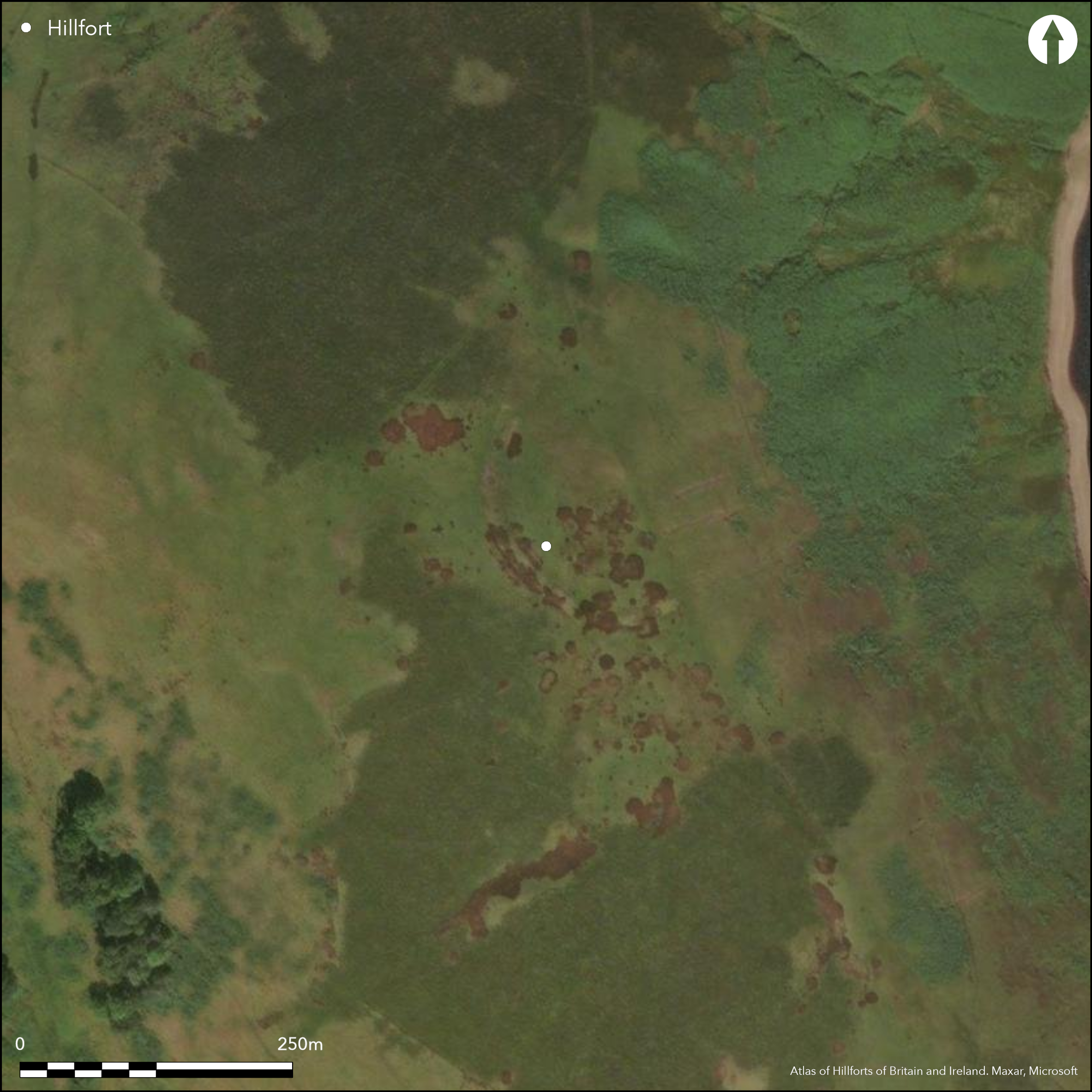
Satellite Imagery
Satellite Imagery
HER: Dumfries & Galloway MDG212 (None)
NMR: NS 80 SE 7 (46376)
SM: None
NGR: NS 8923 0057
X: 289230 Y: 600570 (OSGB36)
The remains of a complex timber-built fortification are situated within a discontinuous earthwork enclosing the summit of Morton Mains Hill. Probably representing a series of separate enclosures, it is not possible to establish the sequence of their construction. Nonetheless, the innermost complete circuit comprises twin palisade trenches set about 1.8m apart and enclosing an oval area measuring 86m from N to S by 59m transversely (0.4ha). Some 9-10m outside this, there is a single palisade forming an enclosure measuring 118m from N to S by 70m transversely (0.65ha), and immediately outside this lies the discontinuous earthwork, which encloses a slightly larger area of 0.75ha. Where best formed in the W sector, this perimeter comprises a relatively slight rampart internally, but with its scarp rising to a height in the order of 3m above the bottom of the external ditch, which is up to 3m in breadth by 0.8m in depth. This sector terminates abruptly on the NW, immediately adjacent to where oblique aerial photography indicates that there is a timber-lined passage dropping down from an entrance through the inner pair of palisades to a corresponding gap in the outer palisade. In 1955 RCAHMS investigators placed an entrance through both palisaded circuits on the SSE, opposite one of five gaps in the earthwork in the southern sector, though this was not located by Martin Fletcher of the OS drawing up a divorced survey in 1978. The ditch has evidently been dug in segments along its entire length, but while this may indicate that it is unfinished, what is described as a marker trench immediately at the rear of the rampart on the S is as likely to be the remains of another line of palisading. Apart from a stony mound on the summit, which is possibly an earlier burial cairn, the only other feature visible within the interior is an additional groove on the N, which has the appearance of another palisade trench, but if so the rest of its circuit is no longer visible. It was the opinion of RCAHMS investigators that this side of the summit had been under cultivation, but the only cultivation remains visible in the detail revealed by oblique aerial photographs taken under light snow in 1991 is evidence of cord rig below the line of the earthwork around the NW flank of the hill.
Citizen Science: ✗
Reliability of Data: Confirmed
Reliability of Interpretation: Confirmed
X: -416971 Y: 7417726 (EPSG: 3857)
Longitude: -3.745713777781616 Latitude: 55.28678730500552 (EPSG:4326)
Country: Scotland
Current County or Unitary Authority: Dumfries & Galloway
Historic County: Dumfriesshire
Current Parish/Community/Council/Townland: Morton
None
| Extant | ✓ |
| Cropmark | ✗ |
| Likely Destroyed | ✗ |
None
| Woodland | ✗ |
| Commercial Forestry Plantation | ✗ |
| Parkland | ✗ |
| Pasture (Grazing) | ✓ |
| Arable | ✗ |
| Scrub/Bracken | ✗ |
| Bare Outcrop | ✗ |
| Heather/Moorland | ✓ |
| Heath | ✗ |
| Built-up | ✗ |
| Coastal Grassland | ✗ |
| Other | ✗ |
None
| Contour Fort | ✓ |
| Partial Contour Fort | ✗ |
| Promontory Fort | ✗ |
| Hillslope Fort | ✗ |
| Level Terrain Fort | ✗ |
| Marsh Fort | ✗ |
| Multiple Enclosure Fort | ✗ |
| Hilltop | ✓ |
| Coastal Promontory | ✗ |
| Inland Promontory | ✗ |
| Valley Bottom | ✗ |
| Knoll/Hillock/Outcrop | ✗ |
| Ridge | ✗ |
| Cliff/Plateau-edge/Scarp | ✗ |
| Hillslope | ✗ |
| Lowland | ✗ |
| Spur | ✗ |
Dominant Topographic Feature: None
| North | ✗ |
| Northeast | ✗ |
| East | ✗ |
| Southeast | ✗ |
| South | ✗ |
| Southwest | ✗ |
| West | ✗ |
| Northwest | ✗ |
| Level | ✓ |
Altitude: 325.0m
N/A
In the absence of excavation, there are neither stratified artefacts nor radiocarbon dates to provide a chronology for the defences.
Reliability: D - None
| Pre 1200BC | ✗ |
| 1200BC - 800BC | ✗ |
| 800BC - 400BC | ✗ |
| 400BC - AD50 | ✗ |
| AD50 - AD400 | ✗ |
| AD400 - AD 800 | ✗ |
| Post AD800 | ✗ |
| Unknown | ✓ |
| Pre Hillfort: | None |
| Post Hillfort: | None |
First depicted in 1856 on the 1st edition OS 25-inch map (Dumfriesshire 1861, sheet 22.3), it was noted by Alexander Curle in 1912, who described the discontinuous character of the earthwork and speculated that it had the 'appearance of a construction whose progress has been arrested before completion' (RCAHMS 1920, 180, no.511). RCAHMS returned to plan the remains in 1955 as part of the Survey of Marginal Lands (Feachem 1955, 63-4; 1963, 117-18), and RCAHMS has subsequently taken oblique aerial photographs in 1991 and 2001. Martin Fletcher of the OS drew up a divorced survey at 1:2500 in 1978.
| 1st Identified Map Depiction (1856): | Annotated Camp in Roman type on the 1st edition OS 25-inch map (Dumfriesshire 1861, sheet 22.3) |
| Other (1912): | Description (RCAHMS 1920, 180, no.511) |
| Earthwork Survey (1955): | Plan and description during RCAHMS Survey of Marginal Lands (Feachem 1955, 63-4; 1963, 117-18; RCAHMS DFD 4/2 & DP160653; DFD 4/1 & DP160654) |
| Earthwork Survey (1978): | Surveyed at 1:2500 by Martin Fletcher of the OS (RCAHMS SC866919) |
Featureless apart from the lines of palisade trenches
None
| None | ✓ |
| Spring | ✗ |
| Stream | ✗ |
| Pool | ✗ |
| Flush | ✗ |
| Well | ✗ |
| Other | ✗ |
Palisade trenches
| No Known Features | ✗ |
| Round Stone Structures | ✗ |
| Rectangular Stone Structures | ✗ |
| Curvilinear Platforms | ✗ |
| Other Roundhouse Evidence | ✗ |
| Pits | ✗ |
| Quarry Hollows | ✗ |
| Other | ✓ |
None
| No Known Excavation | ✓ |
| Pits | ✗ |
| Postholes | ✗ |
| Roundhouses | ✗ |
| Rectangular Structures | ✗ |
| Roads/Tracks | ✗ |
| Quarry Hollows | ✗ |
| Other | ✗ |
| Nothing Found | ✗ |
None
| No Known Geophysics | ✓ |
| Pits | ✗ |
| Roundhouses | ✗ |
| Rectangular Structures | ✗ |
| Roads/Tracks | ✗ |
| Quarry Hollows | ✗ |
| Other | ✗ |
| Nothing Found | ✗ |
None
| No Known Finds | ✓ |
| Pottery | ✗ |
| Metal | ✗ |
| Metalworking | ✗ |
| Human Bones | ✗ |
| Animal Bones | ✗ |
| Lithics | ✗ |
| Environmental | ✗ |
| Other | ✗ |
Palisade trenches
| APs Not Checked | ✗ |
| None | ✗ |
| Roundhouses | ✗ |
| Rectangular Structures | ✗ |
| Pits | ✗ |
| Postholes | ✗ |
| Roads/Tracks | ✗ |
| Other | ✓ |
See main summary
| 6: | Segmental earthwork with a series of original gaps, though only one on the SSE possibly an entrance |
| 2: | None |
Guard Chambers: ✗
Chevaux de Frise: ✗
| 1. Simple Gap (South): | Supposedly through both the earthworks and palisades |
| 2. Passage-way/Corridor (North west): | Formed by palisade trenches |
At least two separate palisaded circuits and one of a rampart and ditch
| Area 1: | 0.4ha. |
| Area 2: | 0.65ha. |
| Area 3: | 0.75ha. |
| Total: | 0.75ha. |
Total Footprint Area: 0.75ha.
None
| ✓ | None |
| ✗ | This refers only to the earthwork element |
| NE Quadrant: | 0 |
| SE Quadrant: | 1 |
| SW Quadrant: | 1 |
| NW Quadrant: | 1 |
| Total: | 1 |
| Partial Univallate | ✓ |
| Univallate | ✗ |
| Partial Bivallate | ✗ |
| Bivallate | ✗ |
| Partial Multivallate | ✗ |
| Multivallate | ✗ |
| Unknown | ✗ |
| Partial Univallate | ✗ |
| Univallate | ✗ |
| Partial Bivallate | ✗ |
| Bivallate | ✗ |
| Partial Multivallate | ✗ |
| Multivallate | ✗ |
Commonly identified as an unfinished fort
| None | ✗ |
| Earthen Bank | ✓ |
| Stone Wall | ✗ |
| Rubble | ✗ |
| Wall-walk | ✗ |
| Evidence of Timber | ✗ |
| Vitrification | ✗ |
| Other Burning | ✗ |
| Palisade | ✓ |
| Counter Scarp Bank | ✗ |
| Berm | ✗ |
| Unfinished | ✓ |
| Other | ✗ |
None
| None | ✗ |
| Earthen Bank | ✗ |
| Stone Wall | ✗ |
| Murus Duplex | ✗ |
| Timber-framed | ✗ |
| Timber-laced | ✗ |
| Vitrification | ✗ |
| Other Burning | ✗ |
| Palisade | ✗ |
| Counter Scarp Bank | ✗ |
| Berm | ✗ |
| Unfinished | ✗ |
| No Known Excavation | ✓ |
| Other | ✗ |
| ✓ | Segmental ditch. |
| ✓ | None |
Number of Ditches: 1
| ✓ | Assuming that the inner and outer palisade trenches are contemporary, the outer encloses an additional 0.25ha, creating a total of 0.65ha. |
Feachem, R W (1955) 'Iron Age and early medieval monuments in Galloway and Dumfriesshire'. Trans Dumfriesshire Galloway Natur Hist Antiq Soc, 3 ser, 33 (1954-5), 58-65
Page(s): 62-4 Feachem, R (1963) A guide to prehistoric Scotland. Batsford: London
RCAHMS (1920) The Royal Commission on the Ancient and Historical Monuments and Constructions of Scotland. Seventh report with inventory of monuments and constructions in the county of Dumfries. HMSO: Edinburgh
Atlas of Hillforts:
Wikidata:
This work is licensed under CC BY-SA 4.0

 and should be cited as:
Lock, Gary and Ralston, Ian. 2024. Atlas of Hillforts of Britain and Ireland. Available at: https://hillforts.arch.ox.ac.uk
Document Version 1.1