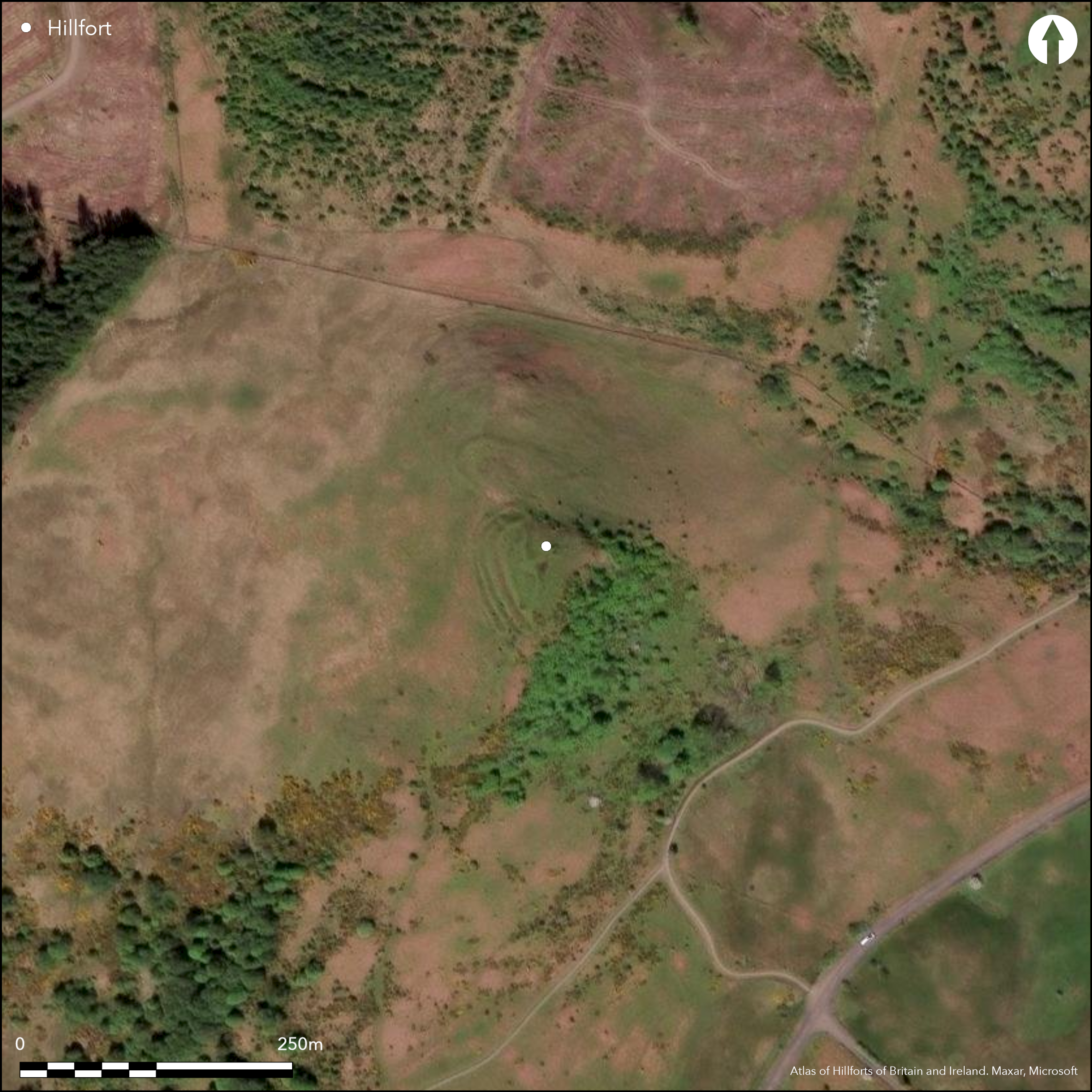
Satellite Imagery
Satellite Imagery
HER: The West of Scotland Archaeology Service 63769 (None)
NMR: NN 60 NW 7 (24375)
SM: 3101
NGR: NN 6014 0759
X: 260140 Y: 707590 (OSGB36)
This fort is situated on the summit of a steep-sided hill which falls away abruptly all along its SE flank. Roughly oval on plan, the defences back onto this natural escarpment, to enclose an area measuring about 50m from N to S by 35m transversely (0.14ha). Elsewhere, on the NW and SW quarters, the defences form a belt some 26m deep, comprising up to four close-set ramparts, probably with intervening ditches, which step down the slope hill. As observed by David Christison (1900, 62-3, fig 22), on the NW the third rampart is pinched out between the second and fourth ramparts, a feature that may indicate that they represent more than one phase of construction. Likewise, if his observation of an entrance through the outer rampart on the SW is correct, then it is blocked by the ramparts above it. Blocks of stone embedded in the scarps of the ramparts indicate that they were stone-faced, while pieces of vitrifaction were observed in 1957 by Kenneth Steer, lying loose in the well within the interior and embedded in the core of the second rampart on the W. Apart from the well, the interior is featureless, as is what may be a contemporary annexe that takes in a terrace below the defences on the NNW; bounded by a bank up to 1.7m high externally, the interior of the annexe measures about 34m from NNW to SSE by 30m transversely (0.09ha). In 1964 a whetstone was found within the interior of the fort (Thomson 1964).
Citizen Science: ✗
Reliability of Data: Confirmed
Reliability of Interpretation: Confirmed
X: -474032 Y: 7606393 (EPSG: 3857)
Longitude: -4.258302528353311 Latitude: 56.24025271914226 (EPSG:4326)
Country: Scotland
Current County or Unitary Authority: Stirling
Historic County: Perthshire
Current Parish/Community/Council/Townland: Callander
None
| Extant | ✓ |
| Cropmark | ✗ |
| Likely Destroyed | ✗ |
None
| Woodland | ✗ |
| Commercial Forestry Plantation | ✗ |
| Parkland | ✗ |
| Pasture (Grazing) | ✓ |
| Arable | ✗ |
| Scrub/Bracken | ✓ |
| Bare Outcrop | ✗ |
| Heather/Moorland | ✓ |
| Heath | ✗ |
| Built-up | ✗ |
| Coastal Grassland | ✗ |
| Other | ✗ |
None
| Contour Fort | ✓ |
| Partial Contour Fort | ✗ |
| Promontory Fort | ✗ |
| Hillslope Fort | ✗ |
| Level Terrain Fort | ✗ |
| Marsh Fort | ✗ |
| Multiple Enclosure Fort | ✗ |
| Hilltop | ✓ |
| Coastal Promontory | ✗ |
| Inland Promontory | ✗ |
| Valley Bottom | ✗ |
| Knoll/Hillock/Outcrop | ✗ |
| Ridge | ✗ |
| Cliff/Plateau-edge/Scarp | ✓ |
| Hillslope | ✗ |
| Lowland | ✗ |
| Spur | ✗ |
Dominant Topographic Feature: None
| North | ✗ |
| Northeast | ✗ |
| East | ✗ |
| Southeast | ✗ |
| South | ✗ |
| Southwest | ✗ |
| West | ✗ |
| Northwest | ✗ |
| Level | ✓ |
Altitude: 200.0m
N/A
In the absence of excavation, there are neither stratified artefacts nor radiocarbon dates to provide a chronology for the defences.
Reliability: D - None
| Pre 1200BC | ✗ |
| 1200BC - 800BC | ✗ |
| 800BC - 400BC | ✗ |
| 400BC - AD50 | ✗ |
| AD50 - AD400 | ✗ |
| AD400 - AD 800 | ✗ |
| Post AD800 | ✗ |
| Unknown | ✓ |
| Pre Hillfort: | None |
| Post Hillfort: | None |
RCAHMS holds an extensive collection of oblique aerial photographs taken in 1971, 1998 and 1999
| 1st Identified Written Reference (1777): | Letter identifying vitrifaction from J Williams in Soc Ant Scotland archives (Nisbet 1975, 14) |
| 1st Identified Map Depiction (1783): | Old Castle on James Stobie's map of the Counties of Perth and Clackmannan (1783) |
| Other (1837): | Noted (NSA, 10, Perthshire, 354-5) |
| Other (1862): | Annotated Fort and Well on the 1st edition OS 25-inch map (Perth and Clackmannan 1866, sheet 123.4) |
| Other (1872): | Noted (Maclagan 1872, 36) |
| Earthwork Survey (1900): | Sketch-plan and description by David Christison (1900, 62-3) |
| Other (1957): | Description for RCAHMS Survey of Marginal Lands |
| Other (1964): | Whetstone found in the interior (Thomson 1964) |
| Other (1968): | Visited by OS |
| Other (1971): | Scheduled |
| Other (1977): | Noted by RCAHMS field programme |
Featureless apart from the well
None
| None | ✗ |
| Spring | ✗ |
| Stream | ✗ |
| Pool | ✗ |
| Flush | ✗ |
| Well | ✓ |
| Other | ✗ |
Well
| No Known Features | ✗ |
| Round Stone Structures | ✗ |
| Rectangular Stone Structures | ✗ |
| Curvilinear Platforms | ✗ |
| Other Roundhouse Evidence | ✗ |
| Pits | ✗ |
| Quarry Hollows | ✗ |
| Other | ✓ |
None
| No Known Excavation | ✓ |
| Pits | ✗ |
| Postholes | ✗ |
| Roundhouses | ✗ |
| Rectangular Structures | ✗ |
| Roads/Tracks | ✗ |
| Quarry Hollows | ✗ |
| Other | ✗ |
| Nothing Found | ✗ |
None
| No Known Geophysics | ✓ |
| Pits | ✗ |
| Roundhouses | ✗ |
| Rectangular Structures | ✗ |
| Roads/Tracks | ✗ |
| Quarry Hollows | ✗ |
| Other | ✗ |
| Nothing Found | ✗ |
Whetstone (Thomson 1964)
| No Known Finds | ✗ |
| Pottery | ✗ |
| Metal | ✗ |
| Metalworking | ✗ |
| Human Bones | ✗ |
| Animal Bones | ✗ |
| Lithics | ✓ |
| Environmental | ✗ |
| Other | ✗ |
Well
| APs Not Checked | ✗ |
| None | ✗ |
| Roundhouses | ✗ |
| Rectangular Structures | ✗ |
| Pits | ✗ |
| Postholes | ✗ |
| Roads/Tracks | ✗ |
| Other | ✓ |
See main summary
| 1: | None |
| 2: | Position unknown |
Guard Chambers: ✗
Chevaux de Frise: ✗
| 1. Simple Gap (South west): | Identified by Christison in the outer rampart (1900, 62) |
Up to four close-set ramparts around the NW and SW
| Area 1: | 0.14ha. |
| Total: | 0.14ha. |
Total Footprint Area: 0.45ha.
None
| ✗ | None |
| ✗ | None |
| NE Quadrant: | 1 |
| SE Quadrant: | 0 |
| SW Quadrant: | 4 |
| NW Quadrant: | 4 |
| Total: | 4 |
| Partial Univallate | ✓ |
| Univallate | ✗ |
| Partial Bivallate | ✗ |
| Bivallate | ✗ |
| Partial Multivallate | ✓ |
| Multivallate | ✗ |
| Unknown | ✗ |
| Partial Univallate | ✗ |
| Univallate | ✗ |
| Partial Bivallate | ✗ |
| Bivallate | ✗ |
| Partial Multivallate | ✗ |
| Multivallate | ✗ |
Grass-grown rubble
| None | ✗ |
| Earthen Bank | ✓ |
| Stone Wall | ✗ |
| Rubble | ✓ |
| Wall-walk | ✗ |
| Evidence of Timber | ✗ |
| Vitrification | ✓ |
| Other Burning | ✗ |
| Palisade | ✗ |
| Counter Scarp Bank | ✗ |
| Berm | ✗ |
| Unfinished | ✗ |
| Other | ✗ |
None
| None | ✗ |
| Earthen Bank | ✗ |
| Stone Wall | ✗ |
| Murus Duplex | ✗ |
| Timber-framed | ✗ |
| Timber-laced | ✗ |
| Vitrification | ✗ |
| Other Burning | ✗ |
| Palisade | ✗ |
| Counter Scarp Bank | ✗ |
| Berm | ✗ |
| Unfinished | ✗ |
| No Known Excavation | ✓ |
| Other | ✗ |
| ✗ | None |
| ✓ | None |
Number of Ditches: 4
| ✓ | The annexe takes in a terrace below the defences on the NNW; bounded by a bank up to 1.7m high externally, its interior measures about 34m from NNW to SSE by 30m transversely (0.09ha). |
Christison, D (1900) 'The forts, "camps", and other field-works of Perth, Forfar and Kincardine'. Proc Soc Antiq Scot 34 (1899-1900), 43-120
Maclagan, C (1873) 'On the round castles and ancient dwellings of the Valley of the Forth and its tributary the Teith'. Proc Soc Antiq Scot 9 (1870-72), 29-44
NSA (1834-1845) The new statistical account of Scotland by the ministers of the respective parishes under the superintendence of a committee of the society for the benefit of the sons and daughters of the clergy, 15v Edinburgh
Nisbet, H C (1975) 'A geological approach to vitrified forts, part II: bedrock and building stone'. Sci & Archaeol 15 (1975), 3-16
Stat Acct (date) Statistical Account of Scotland: Drawn up from the Communications of the Ministers of the Different Parishes (Sinclair, J ed), 1791-99 (xi, 1797, 607)
Thomson, J K (1964) 'Dunmore, Callender'. Disc Exc Scot (1964), 41
Atlas of Hillforts:
Wikidata:
This work is licensed under CC BY-SA 4.0

 and should be cited as:
Lock, Gary and Ralston, Ian. 2024. Atlas of Hillforts of Britain and Ireland. Available at: https://hillforts.arch.ox.ac.uk
Document Version 1.1