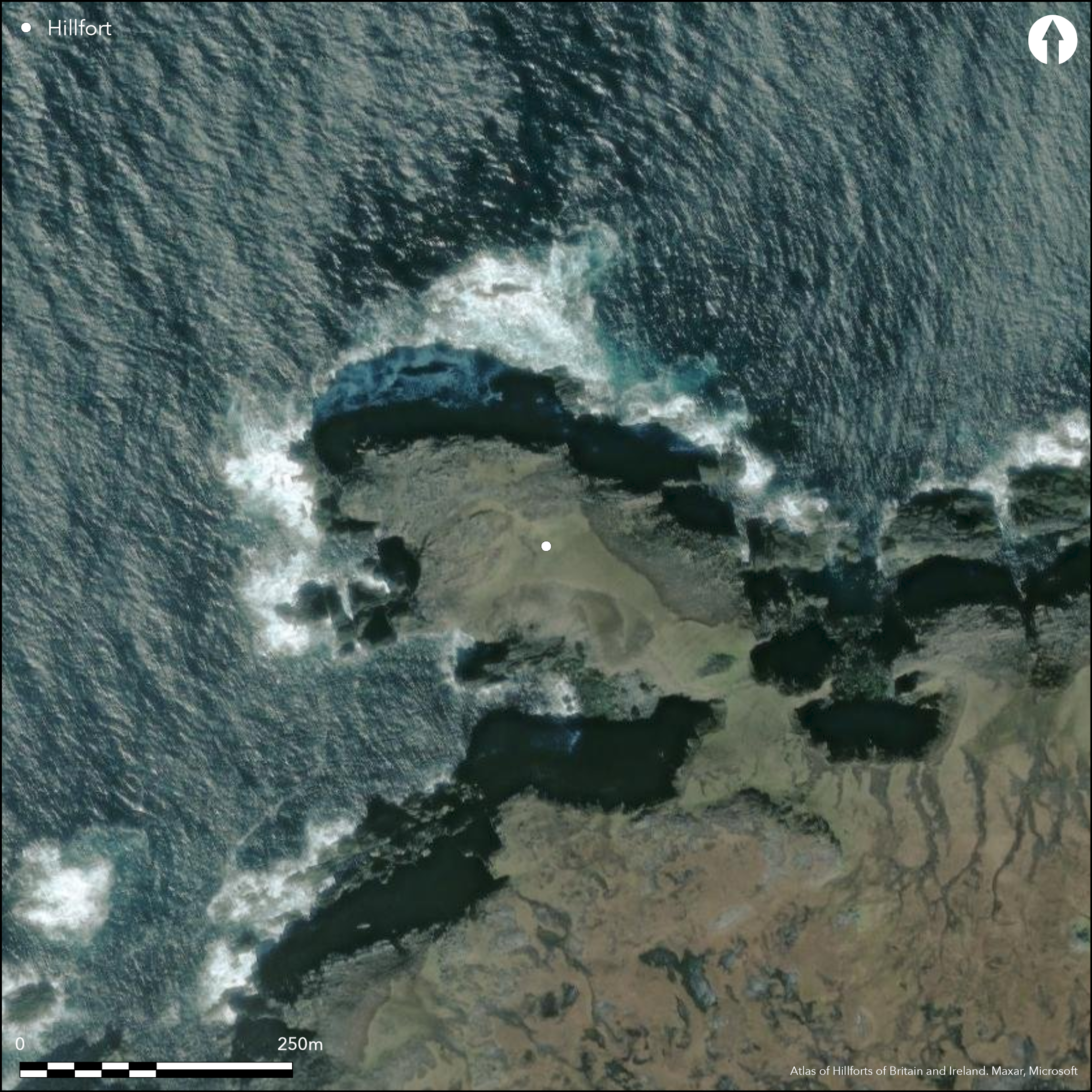
Satellite Imagery
Satellite Imagery
HER: Comhairle nan Eilean Siar - Western Isles Sites and Monuments Record MWE4204 (None)
NMR: NB 24 NW 2 (4204)
SM: None
NGR: NB 2360 4739
X: 123605 Y: 947397 (OSGB36)
This fort occupies a large cliff-girt promontory running out into the sea to the NW of South Shawbost. Its defences comprise the remains of three walls, which have been drawn across the neck of the promontory to bar access to an area of measuring about 205m from ESE to WNW by up to 95m transversely (1.2ha), though for a distance of about 100m behind the defences, heavy erosion along its flanks of the till deposits capping the outcrop is actively reducing its original surface area. The innermost of the walls has probably been the thickest, though it is now difficult to determine an exact measurement. The line of the outer face is clearly distinguishable, backed at either end by a band of debris spread between 2m and 3m in thickness, but most of the rubble has been drawn together into the central sector, where there is a massive mound of stones about 10m broad by up to 0.8m high. Presumably the result of a later occupation, traces of several structures can be detected within the body of the mound. The two outer walls, set at intervals of 7m and 3m apart, have been reduced to low banks 2m thick by 0.4m high studded with a few boulders, some of which probably belong to their faces. Traces of a later rectilinear enclosure can be seen inserted into the gap between the inner and middle wall on the W. The position of the original entrance into the fort is uncertain, and it is now difficult to determine whether the gap identified as the entrance at the W end of the inner wall by RCAHMS investigators in 1914, where the wall peters out on the eroding flank of the promontory, is the result of accident or design. The interior is made up of two elements, comprising a gentle grassy slope at the landward end from which the outcrops rise up above a natural sea arch to a summit at 32m OD. While this end is largely bare rock, traces of low cultivation ridge can be seen on the slope dropping down the cropped sward towards the NE, and probably overriding the footings of a rectangular building on the crest of the slope on the WSW; measuring overall about 15m in length by 5m in breadth, two slabs set about 0.8m apart in the SE end may mark the position of its entrance.
Citizen Science: ✗
Reliability of Data: Confirmed
Reliability of Interpretation: Confirmed
X: -748428 Y: 8036504 (EPSG: 3857)
Longitude: -6.723245533793102 Latitude: 58.327838149100415 (EPSG:4326)
Country: Scotland
Current County or Unitary Authority: Western Isles
Historic County: Ross-shire
Current Parish/Community/Council/Townland: Barvas
None
| Extant | ✓ |
| Cropmark | ✗ |
| Likely Destroyed | ✗ |
None
| Woodland | ✗ |
| Commercial Forestry Plantation | ✗ |
| Parkland | ✗ |
| Pasture (Grazing) | ✓ |
| Arable | ✗ |
| Scrub/Bracken | ✗ |
| Bare Outcrop | ✗ |
| Heather/Moorland | ✓ |
| Heath | ✗ |
| Built-up | ✗ |
| Coastal Grassland | ✓ |
| Other | ✗ |
None
| Contour Fort | ✗ |
| Partial Contour Fort | ✗ |
| Promontory Fort | ✓ |
| Hillslope Fort | ✗ |
| Level Terrain Fort | ✗ |
| Marsh Fort | ✗ |
| Multiple Enclosure Fort | ✗ |
| Hilltop | ✗ |
| Coastal Promontory | ✓ |
| Inland Promontory | ✗ |
| Valley Bottom | ✗ |
| Knoll/Hillock/Outcrop | ✗ |
| Ridge | ✗ |
| Cliff/Plateau-edge/Scarp | ✗ |
| Hillslope | ✗ |
| Lowland | ✗ |
| Spur | ✗ |
Dominant Topographic Feature: None
| North | ✗ |
| Northeast | ✗ |
| East | ✗ |
| Southeast | ✗ |
| South | ✗ |
| Southwest | ✗ |
| West | ✗ |
| Northwest | ✗ |
| Level | ✓ |
Altitude: 30.0m
N/A
In the absence of excavation, there are neither stratified artefacts nor radiocarbon dates to provide a chronology for the defences.
Reliability: D - None
| Pre 1200BC | ✗ |
| 1200BC - 800BC | ✗ |
| 800BC - 400BC | ✗ |
| 400BC - AD50 | ✗ |
| AD50 - AD400 | ✗ |
| AD400 - AD 800 | ✗ |
| Post AD800 | ✗ |
| Unknown | ✓ |
| Pre Hillfort: | None |
| Post Hillfort: | Robbed to build structures behind the wall, in addition to the footings of a rectangular building and later cultivation rigs |
The description by Captain Thomas suggests that there was a well-preserved entrance visible in his day in the early 1860s. He recognised the presence of later structures built against the wall, but also cryptically other faces in the wall and a covered passage roofed with flags (1890, 382). The line of the wall appears on the 1st edition OS 6-inch map (Ross-shire, Island of Lewis 1853, sheet 7) Photographed by RCAHMS Aerial Survey Programme in 2004.
| 1st Identified Written Reference (1865): | Description By Captain F W Thomas (1890, 382; RCAHMS MS28/33) |
| Other (1914): | Description (RCAHMS 1928, 6, no.12) |
| 1st Identified Map Depiction (1969): | Visited by the OS |
| Other (2014): | Description by S Halliday |
Rectangular building and other structures; a;so lazy-beds
None
| None | ✓ |
| Spring | ✗ |
| Stream | ✗ |
| Pool | ✗ |
| Flush | ✗ |
| Well | ✗ |
| Other | ✗ |
Structures in the mound of rubble behind the wall
| No Known Features | ✗ |
| Round Stone Structures | ✗ |
| Rectangular Stone Structures | ✓ |
| Curvilinear Platforms | ✗ |
| Other Roundhouse Evidence | ✗ |
| Pits | ✗ |
| Quarry Hollows | ✗ |
| Other | ✓ |
None
| No Known Excavation | ✓ |
| Pits | ✗ |
| Postholes | ✗ |
| Roundhouses | ✗ |
| Rectangular Structures | ✗ |
| Roads/Tracks | ✗ |
| Quarry Hollows | ✗ |
| Other | ✗ |
| Nothing Found | ✗ |
None
| No Known Geophysics | ✓ |
| Pits | ✗ |
| Roundhouses | ✗ |
| Rectangular Structures | ✗ |
| Roads/Tracks | ✗ |
| Quarry Hollows | ✗ |
| Other | ✗ |
| Nothing Found | ✗ |
None
| No Known Finds | ✓ |
| Pottery | ✗ |
| Metal | ✗ |
| Metalworking | ✗ |
| Human Bones | ✗ |
| Animal Bones | ✗ |
| Lithics | ✗ |
| Environmental | ✗ |
| Other | ✗ |
None
| APs Not Checked | ✗ |
| None | ✗ |
| Roundhouses | ✗ |
| Rectangular Structures | ✓ |
| Pits | ✗ |
| Postholes | ✗ |
| Roads/Tracks | ✗ |
| Other | ✗ |
See main summary
| 0: | None |
| 2: | No clear entrance visible, but probably across the neck on the SE |
Guard Chambers: ✗
Chevaux de Frise: ✗
Three walls across a promontory
| Area 1: | 1.2ha. |
| Total: | 1.2ha. |
Total Footprint Area: Noneha.
None
| ✗ | None |
| ✗ | None |
| NE Quadrant: | 0 |
| SE Quadrant: | 3 |
| SW Quadrant: | 0 |
| NW Quadrant: | 0 |
| Total: | 3 |
| Partial Univallate | ✗ |
| Univallate | ✗ |
| Partial Bivallate | ✗ |
| Bivallate | ✗ |
| Partial Multivallate | ✓ |
| Multivallate | ✗ |
| Unknown | ✗ |
| Partial Univallate | ✗ |
| Univallate | ✗ |
| Partial Bivallate | ✗ |
| Bivallate | ✗ |
| Partial Multivallate | ✗ |
| Multivallate | ✗ |
None
| None | ✗ |
| Earthen Bank | ✗ |
| Stone Wall | ✓ |
| Rubble | ✗ |
| Wall-walk | ✗ |
| Evidence of Timber | ✗ |
| Vitrification | ✗ |
| Other Burning | ✗ |
| Palisade | ✗ |
| Counter Scarp Bank | ✗ |
| Berm | ✗ |
| Unfinished | ✗ |
| Other | ✗ |
None
| None | ✗ |
| Earthen Bank | ✗ |
| Stone Wall | ✗ |
| Murus Duplex | ✗ |
| Timber-framed | ✗ |
| Timber-laced | ✗ |
| Vitrification | ✗ |
| Other Burning | ✗ |
| Palisade | ✗ |
| Counter Scarp Bank | ✗ |
| Berm | ✗ |
| Unfinished | ✗ |
| No Known Excavation | ✓ |
| Other | ✗ |
| ✗ | None |
| ✗ | None |
Number of Ditches: None
| ✗ | None |
Burgess, C (1999) 'Promontory enclosures on the Isle of Lewis, the Western Isles, Scotland'. In Frodsham, P, Topping, P and Cowley, D 1999 'We were always chasing time.' Papers presented to Keith Blood. Northern Archaeol (Spec Edition) 17/18 (1999), 93
RCAHMS (1928) The Royal Commission on the Ancient and Historical Monuments and Constructions of Scotland. Ninth report with inventory of monuments and constructions in the Outer Hebrides, Skye and the Small Isles. HMSO: Edinburgh
Thomas, F W L (1890) 'On the duns of the Outer Hebrides'. Archaeol Scot 5 (1890), 365-415
Atlas of Hillforts:
Wikidata:
This work is licensed under CC BY-SA 4.0

 and should be cited as:
Lock, Gary and Ralston, Ian. 2024. Atlas of Hillforts of Britain and Ireland. Available at: https://hillforts.arch.ox.ac.uk
Document Version 1.1