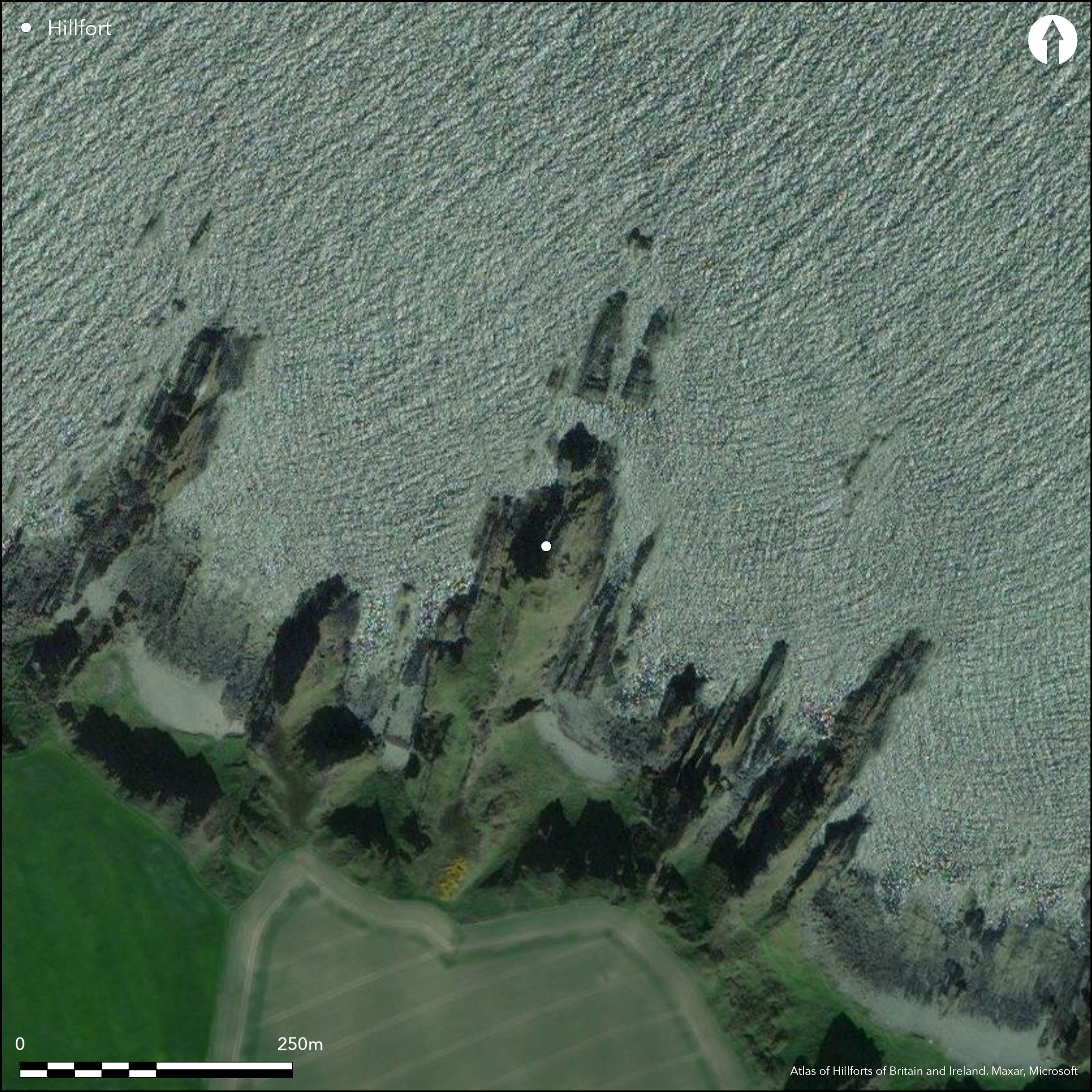
Satellite Imagery
Satellite Imagery
HER: Aberdeenshire Historic Environment Record NJ76SW0007 (None)
NMR: NJ 76 SW 7 (19301)
SM: None
NGR: NJ 7292 6473
X: 372920 Y: 864730 (OSGB36)
Access to this spine of rock, which projects some 220m from the coastal escarpment out into the sea, is barred at the landward end by a rampart with an external ditch; the rampart forms a bank 1.7m high. To its rear there are possible traces of a rectangular footing, while at the far end of the interior, beyond a narrow rocky cleft across its spine, which is nowhere more than 15m in breadth there are the remains of what is probably a rectangular structure with a sunken floor adjoining a slightly large rectangular building. The sunken-floored structure, which was excavated on several occasions in the 19th century (Hunter 1868), measures about 4.6m in length by 3m in breadth and is presently about 0.7m in depth. According to James Hunter, a Mr Paterson of Longmanhill and Mr Joseph Robertson found a floor of baked clay at a depth of 4.2m, and recovered unidentified bones and teeth, and a glass bead (Hunter 1868, 466), presumably the amber bead donated to the National Museum of Antiquities about 1862 (see Donations in Proc Soc Antiq Scot 4). Hunter himself claimed to find small stones 'burned so as to resemble those from a vitrified fort' (ibid). The only other features visible within the narrow interior, which perhaps extends to as much as 0.26ha overall, are two lengths of stone facing adjacent to the rocky cleft halfway along the promontory; the OS surveyor suggested these were parts of a retaining wall for a path.
Citizen Science: ✗
Reliability of Data: Confirmed
Reliability of Interpretation: Confirmed
X: -273359 Y: 7898666 (EPSG: 3857)
Longitude: -2.455625186137837 Latitude: 57.67169981889842 (EPSG:4326)
Country: Scotland
Current County or Unitary Authority: Aberdeenshire
Historic County: Banffshire
Current Parish/Community/Council/Townland: Gamrie
None
| Extant | ✓ |
| Cropmark | ✗ |
| Likely Destroyed | ✗ |
None
| Woodland | ✗ |
| Commercial Forestry Plantation | ✗ |
| Parkland | ✗ |
| Pasture (Grazing) | ✗ |
| Arable | ✗ |
| Scrub/Bracken | ✗ |
| Bare Outcrop | ✗ |
| Heather/Moorland | ✗ |
| Heath | ✗ |
| Built-up | ✗ |
| Coastal Grassland | ✓ |
| Other | ✗ |
None
| Contour Fort | ✗ |
| Partial Contour Fort | ✗ |
| Promontory Fort | ✓ |
| Hillslope Fort | ✗ |
| Level Terrain Fort | ✗ |
| Marsh Fort | ✗ |
| Multiple Enclosure Fort | ✗ |
| Hilltop | ✗ |
| Coastal Promontory | ✓ |
| Inland Promontory | ✗ |
| Valley Bottom | ✗ |
| Knoll/Hillock/Outcrop | ✗ |
| Ridge | ✗ |
| Cliff/Plateau-edge/Scarp | ✗ |
| Hillslope | ✗ |
| Lowland | ✗ |
| Spur | ✗ |
Dominant Topographic Feature: None
| North | ✗ |
| Northeast | ✗ |
| East | ✗ |
| Southeast | ✗ |
| South | ✗ |
| Southwest | ✗ |
| West | ✗ |
| Northwest | ✗ |
| Level | ✓ |
Altitude: 25.0m
N/A
In the absence of modern excavation, there are neither stratified artefacts nor radiocarbon dates to provide a chronology for the defences.
Reliability: D - None
| Pre 1200BC | ✗ |
| 1200BC - 800BC | ✗ |
| 800BC - 400BC | ✗ |
| 400BC - AD50 | ✗ |
| AD50 - AD400 | ✗ |
| AD400 - AD 800 | ✗ |
| Post AD800 | ✗ |
| Unknown | ✓ |
| Pre Hillfort: | None |
| Post Hillfort: | Rectangular buildings |
None
| Excavation (1862): | Noted by (Hunter 1868) |
| Earthwork Survey (1868): | Description by James Hunter, who also drew a plan, though this does not appear to survive (1868, 465-9) |
| Other (1897): | Noted (Forbes 1897, 11) |
| 1st Identified Map Depiction (1963): | Surveyed at 1:2500 by the OS |
| Other (1968): | Revised at 1:2500 by the OS |
Traces of two rectangular buildings and a sunken-floored structure
This assumes that the antiquarian account exaggerated the depth of the sunken-floored structure, which might otherwise be interpreted as a shaft or cistern
| None | ✓ |
| Spring | ✗ |
| Stream | ✗ |
| Pool | ✗ |
| Flush | ✗ |
| Well | ✗ |
| Other | ✗ |
None
| No Known Features | ✗ |
| Round Stone Structures | ✗ |
| Rectangular Stone Structures | ✓ |
| Curvilinear Platforms | ✗ |
| Other Roundhouse Evidence | ✗ |
| Pits | ✗ |
| Quarry Hollows | ✗ |
| Other | ✗ |
Unclear exactly what was discovered
| No Known Excavation | ✗ |
| Pits | ✗ |
| Postholes | ✗ |
| Roundhouses | ✗ |
| Rectangular Structures | ✓ |
| Roads/Tracks | ✗ |
| Quarry Hollows | ✗ |
| Other | ✓ |
| Nothing Found | ✗ |
None
| No Known Geophysics | ✓ |
| Pits | ✗ |
| Roundhouses | ✗ |
| Rectangular Structures | ✗ |
| Roads/Tracks | ✗ |
| Quarry Hollows | ✗ |
| Other | ✗ |
| Nothing Found | ✗ |
Amber bead
| No Known Finds | ✓ |
| Pottery | ✗ |
| Metal | ✗ |
| Metalworking | ✗ |
| Human Bones | ✗ |
| Animal Bones | ✓ |
| Lithics | ✗ |
| Environmental | ✗ |
| Other | ✓ |
NO APPARENT FEATURES
| APs Not Checked | ✗ |
| None | ✓ |
| Roundhouses | ✗ |
| Rectangular Structures | ✗ |
| Pits | ✗ |
| Postholes | ✗ |
| Roads/Tracks | ✗ |
| Other | ✗ |
See main summary
| 0: | None |
| 2: | Not visible but presumably at the landward end on the SSW |
Guard Chambers: ✗
Chevaux de Frise: ✗
Single rampart and ditch
| Area 1: | 0.26ha. |
| Total: | 0.26ha. |
Total Footprint Area: Noneha.
None
| ✗ | None |
| ✗ | None |
| NE Quadrant: | 0 |
| SE Quadrant: | 0 |
| SW Quadrant: | 1 |
| NW Quadrant: | 0 |
| Total: | 1 |
| Partial Univallate | ✓ |
| Univallate | ✗ |
| Partial Bivallate | ✗ |
| Bivallate | ✗ |
| Partial Multivallate | ✗ |
| Multivallate | ✗ |
| Unknown | ✗ |
| Partial Univallate | ✗ |
| Univallate | ✗ |
| Partial Bivallate | ✗ |
| Bivallate | ✗ |
| Partial Multivallate | ✗ |
| Multivallate | ✗ |
None
| None | ✗ |
| Earthen Bank | ✓ |
| Stone Wall | ✗ |
| Rubble | ✗ |
| Wall-walk | ✗ |
| Evidence of Timber | ✗ |
| Vitrification | ✗ |
| Other Burning | ✗ |
| Palisade | ✗ |
| Counter Scarp Bank | ✗ |
| Berm | ✗ |
| Unfinished | ✗ |
| Other | ✗ |
Within the interior rather than across the defences
| None | ✗ |
| Earthen Bank | ✗ |
| Stone Wall | ✗ |
| Murus Duplex | ✗ |
| Timber-framed | ✗ |
| Timber-laced | ✗ |
| Vitrification | ✗ |
| Other Burning | ✗ |
| Palisade | ✗ |
| Counter Scarp Bank | ✗ |
| Berm | ✗ |
| Unfinished | ✗ |
| No Known Excavation | ✗ |
| Other | ✓ |
| ✗ | None |
| ✓ | None |
Number of Ditches: 1
| ✗ | None |
Forbes, W (1897) Notes in Trans Banffshire Fld Club (1892-7), 11
Hunter, J (1868) 'Description of Pit Dwellings at Dilly-moenan and the Miaave Craig, Tarlair, near Macduff, Banffshire'. Proc Soc Antiq Scot 7 (1866-68), 465-71
Atlas of Hillforts:
Wikidata:
This work is licensed under CC BY-SA 4.0

 and should be cited as:
Lock, Gary and Ralston, Ian. 2024. Atlas of Hillforts of Britain and Ireland. Available at: https://hillforts.arch.ox.ac.uk
Document Version 1.1