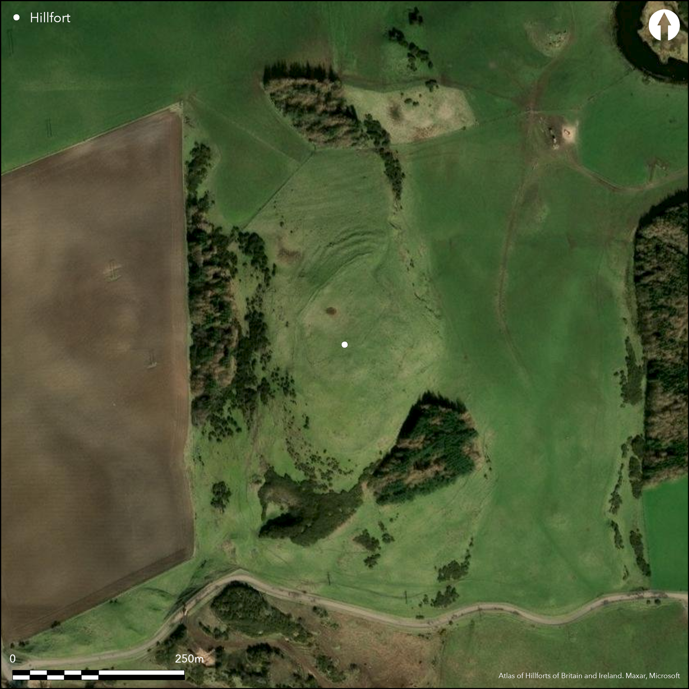
Satellite Imagery
Satellite Imagery
HER: Perth and Kinross Heritage Trust MPK3251 (None)
NMR: NO 12 NE 2 (28116)
SM: 3089
NGR: NO 1703 2589
X: 317031 Y: 725894 (OSGB36)
This fort occupies the broad summit of Law Hill W of Arnbathie. Oval on plan, it measures 154m from N to S by 90m transversely (1ha) within a heavily robbed rampart overlain by an old field-dyke that follows the shoulder of the summit. Representing the natural line of defence, where the ground falls away more steeply on all sides, but particularly on the W, this probably always formed the innermost circuit of defence, but on the N, where access was easiest, there are up to five outer ramparts, probably representing several periods of construction, though their precise sequence and chronology are unknown. Elsewhere, traces of a single outer rampart are visible around most of the circuit, and on the S a separate outwork appears to have taken in a lower terrace occupied by a single hut-circle. Trackways mount the slope obliquely through entrances on the N, E, S and W, and while three expose the righthand side of the visitor, that on the W exposes the lefthand side. The N entrance, where the sinous trackway is lined with stones, was also defended by a chevaux de frise, which seems to have acted in unison with the outermost ramparts to confined approaching traffic to the edge of a natural escarpment falling away to the E. The interior, at least part of which has been cultivated, is largely featureless, but a damp hollow on the NW is possibly a pond or cistern, and what may be an earlier cairn about 7m in diameter by 0.5m stands on the very summit.
Citizen Science: ✗
Reliability of Data: Confirmed
Reliability of Interpretation: Confirmed
X: -372530 Y: 7642082 (EPSG: 3857)
Longitude: -3.346490608655478 Latitude: 56.4180030718443 (EPSG:4326)
Country: Scotland
Current County or Unitary Authority: Perth & Kinross
Historic County: Perthshire
Current Parish/Community/Council/Townland: Kilspindie
None
| Extant | ✓ |
| Cropmark | ✗ |
| Likely Destroyed | ✗ |
None
| Woodland | ✗ |
| Commercial Forestry Plantation | ✗ |
| Parkland | ✗ |
| Pasture (Grazing) | ✓ |
| Arable | ✗ |
| Scrub/Bracken | ✗ |
| Bare Outcrop | ✗ |
| Heather/Moorland | ✓ |
| Heath | ✗ |
| Built-up | ✗ |
| Coastal Grassland | ✗ |
| Other | ✗ |
None
| Contour Fort | ✓ |
| Partial Contour Fort | ✗ |
| Promontory Fort | ✗ |
| Hillslope Fort | ✗ |
| Level Terrain Fort | ✗ |
| Marsh Fort | ✗ |
| Multiple Enclosure Fort | ✗ |
| Hilltop | ✓ |
| Coastal Promontory | ✗ |
| Inland Promontory | ✗ |
| Valley Bottom | ✗ |
| Knoll/Hillock/Outcrop | ✗ |
| Ridge | ✗ |
| Cliff/Plateau-edge/Scarp | ✗ |
| Hillslope | ✗ |
| Lowland | ✗ |
| Spur | ✗ |
Dominant Topographic Feature: None
| North | ✗ |
| Northeast | ✗ |
| East | ✗ |
| Southeast | ✗ |
| South | ✗ |
| Southwest | ✗ |
| West | ✗ |
| Northwest | ✗ |
| Level | ✓ |
Altitude: 213.0m
N/A
In the absence of excavation, there are neither stratified artefacts nor radiocarbon dates to provide a chronology for the defences.
Reliability: D - None
| Pre 1200BC | ✗ |
| 1200BC - 800BC | ✗ |
| 800BC - 400BC | ✗ |
| 400BC - AD50 | ✗ |
| AD50 - AD400 | ✗ |
| AD400 - AD 800 | ✗ |
| Post AD800 | ✗ |
| Unknown | ✓ |
| Pre Hillfort: | Cairn on the summit |
| Post Hillfort: | Overlain by a later field dyke and cultivated |
RCAHMS Aerial Survey Programme has also taken oblique aerial photographs of the fort
| 1st Identified Written Reference (1929): | Description (Watson 1929) |
| Other (1956): | Brief description for RCAHMS Survey of Marginal Lands |
| 1st Identified Map Depiction (1963): | Surveyed at 1:2500 by the OS |
| Earthwork Survey (1971): | Scheduled |
| Other (1989): | Description by RCAHMS |
| Earthwork Survey (1991): | Plan (RCAHMS DC 25079-80; DC25087; RCAHMS 1994, 51, 53) |
| Other (1994): | Visited by the Hill-Fort Study Group |
| Other (1998): | Re-Scheduled |
| Earthwork Survey (2012): | Plan (Oxford North 2012) |
Featureless apart from a damp hollow on the NW
Possible pool or cistern
| None | ✗ |
| Spring | ✗ |
| Stream | ✗ |
| Pool | ✓ |
| Flush | ✗ |
| Well | ✗ |
| Other | ✗ |
None
| No Known Features | ✓ |
| Round Stone Structures | ✗ |
| Rectangular Stone Structures | ✗ |
| Curvilinear Platforms | ✗ |
| Other Roundhouse Evidence | ✗ |
| Pits | ✗ |
| Quarry Hollows | ✗ |
| Other | ✗ |
None
| No Known Excavation | ✓ |
| Pits | ✗ |
| Postholes | ✗ |
| Roundhouses | ✗ |
| Rectangular Structures | ✗ |
| Roads/Tracks | ✗ |
| Quarry Hollows | ✗ |
| Other | ✗ |
| Nothing Found | ✗ |
None
| No Known Geophysics | ✓ |
| Pits | ✗ |
| Roundhouses | ✗ |
| Rectangular Structures | ✗ |
| Roads/Tracks | ✗ |
| Quarry Hollows | ✗ |
| Other | ✗ |
| Nothing Found | ✗ |
None
| No Known Finds | ✓ |
| Pottery | ✗ |
| Metal | ✗ |
| Metalworking | ✗ |
| Human Bones | ✗ |
| Animal Bones | ✗ |
| Lithics | ✗ |
| Environmental | ✗ |
| Other | ✗ |
NO APPARENT FEATURES
| APs Not Checked | ✗ |
| None | ✓ |
| Roundhouses | ✗ |
| Rectangular Structures | ✗ |
| Pits | ✗ |
| Postholes | ✗ |
| Roads/Tracks | ✗ |
| Other | ✗ |
See main summary
| 4: | None |
| 2: | None |
Guard Chambers: ✗
Chevaux de Frise: ✓
| 1. Simple Gap (North): | Sinuous track lined with stones. Oblique approach exposing right side |
| 1. Oblique (North): | Oblique approach exposing right side |
| 2. Simple Gap (East): | Track. Oblique approach exposing right side |
| 2. Oblique (East): | Oblique approach exposing right side |
| 3. Simple Gap (South): | Track. |
| 3. Oblique (South): | Oblique approach exposing right side |
| 4. Over-lapping (West): | Track. Staggered terminals to either side of the gap |
| 4. Oblique (West): | Oblique approach exposing left side |
Two ramparts around most of the circuit, up to six representing several periods of construction on the N
| Area 1: | 1.0ha. |
| Total: | 1.0ha. |
Total Footprint Area: 2.0ha.
None
| ✓ | The three outermost ramparts on the N appear to be overridden by later lines. |
| ✓ | None |
| NE Quadrant: | 2 |
| SE Quadrant: | 2 |
| SW Quadrant: | 3 |
| NW Quadrant: | 6 |
| Total: | 6 |
| Partial Univallate | ✗ |
| Univallate | ✗ |
| Partial Bivallate | ✓ |
| Bivallate | ✗ |
| Partial Multivallate | ✓ |
| Multivallate | ✗ |
| Unknown | ✗ |
| Partial Univallate | ✗ |
| Univallate | ✗ |
| Partial Bivallate | ✗ |
| Bivallate | ✓ |
| Partial Multivallate | ✗ |
| Multivallate | ✗ |
None
| None | ✗ |
| Earthen Bank | ✗ |
| Stone Wall | ✓ |
| Rubble | ✗ |
| Wall-walk | ✗ |
| Evidence of Timber | ✗ |
| Vitrification | ✗ |
| Other Burning | ✗ |
| Palisade | ✗ |
| Counter Scarp Bank | ✗ |
| Berm | ✗ |
| Unfinished | ✗ |
| Other | ✗ |
None
| None | ✗ |
| Earthen Bank | ✗ |
| Stone Wall | ✗ |
| Murus Duplex | ✗ |
| Timber-framed | ✗ |
| Timber-laced | ✗ |
| Vitrification | ✗ |
| Other Burning | ✗ |
| Palisade | ✗ |
| Counter Scarp Bank | ✗ |
| Berm | ✗ |
| Unfinished | ✗ |
| No Known Excavation | ✓ |
| Other | ✗ |
| ✗ | None |
| ✗ | None |
Number of Ditches: None
| ✓ | A small annexe containing a single hut-circle lies at the S end, though its rampart, which encloses an area measuring about 60m from ESE to WNW by 20m transversely (0.14ha), cannot now be traced to a junction with the defences and is conceivably the remains of an independent enclosure. |
Oxford North 2012 Hill-Forts of the Inner Tay Estuary, Perth, Perth and Kinross: Phase Two, Archaeological Survey Report
RCAHMS (1994) The Royal Commission on the Ancient and Historical Monuments of Scotland. South-east Perth: an archaeological landscape. HMSO: Edinburgh
Watson, R R B (1929) 'Fortification or hillfort at Arnbathie'. Trans Proc Perthshire Soc Natur Sci 8 (1929), 270-2
Atlas of Hillforts:
Wikidata:
This work is licensed under CC BY-SA 4.0

 and should be cited as:
Lock, Gary and Ralston, Ian. 2024. Atlas of Hillforts of Britain and Ireland. Available at: https://hillforts.arch.ox.ac.uk
Document Version 1.1