Satellite Imagery
Satellite Imagery
HER: Dumfries & Galloway MDG474 (None)
NMR: NT 20 SW 5 (51169)
SM: 4723
NGR: NT 2308 0443
X: 323080 Y: 604430 (OSGB36)
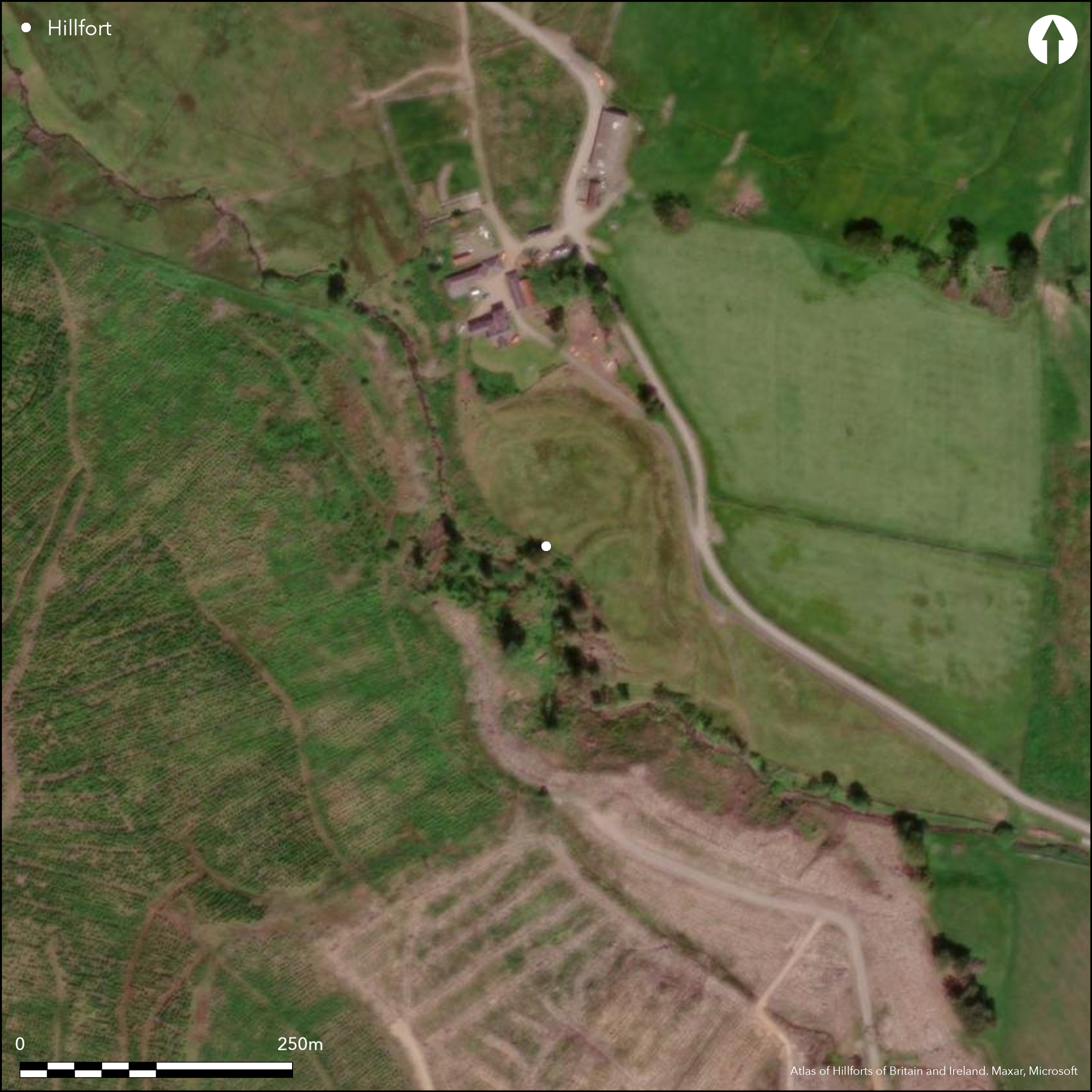
This fort is situated on a steep-sided promontory immediately SSE of Over Cassock, but it had been heavily robbed before the middle of the 19th century (Name Book, Dumfriesshire, no.15, p 26). Despite the evident disturbance and erosion, the surviving remains indicate a complex history, probably of at least three phases, though the sequence between the various elements cannot be demonstrated and remains conjectural. The principal element of the fort comprises a rampart reduced to a bank 8.5m in thickness by 1.2m in height, with an external ditch up to 9m in breadth by 0.6m in depth, which have been drawn across the neck of the promontory on the N and are pierced by an entrance. The interior measures at least 80m in breadth at the N end, but it is unclear whether it originally extended to the very tip of the promontory, 150m to the S (0.63ha), or whether it terminated at an isolated arc of rampart that can be seen crossing about 40m short of the end, thus reducing its length to about 110m (0.56ha). If this is the case, the rampart of the fort may have extended along the margins of the promontory in the manner of an enclosure visible within the interior. Apparently representing a separate phase of construction, the bank of the latter, which measures up to 6m in thickness by 1m in height, lies 8m behind the fort rampart on N and in effect blocks the entrance of the fort on this side. Turning down the margins of the promontory on the E and W, it has been eroded by a meander of the burn on the SW, but probably included the isolated arc of rampart on the S into its circuit to enclose an area measuring 83m from N to S by 77m transversely (0.45ha); there are opposed entrances on the E and W respectively, the former with evidence of a worn hollow dropping down the slope outside, and there is also a gap on the S. The third phase of construction comprises a bank and ditch cutting across the S side of this enclosure; separated by a berm 1.8m wide, the bank is up to 7m thick by 0.6m high and the ditch on its N side is 5.5m broad by 0.8m deep. These are of sufficient scale to represent defences in their own right, but it is uncertain whether they were intended to act in unison with S arc of the earlier rampart, simply dividing off an area measuring 40m from E to W by 27m transversely (0.06ha), or whether the interior extended all the way to the tip of the promontory, a much larger area of 0.14ha.
Citizen Science: ✗
Reliability of Data: Confirmed
Reliability of Interpretation: Confirmed
X: -357774 Y: 7425771 (EPSG: 3857)
Longitude: -3.2139366067026405 Latitude: 55.327920131002834 (EPSG:4326)
Country: Scotland
Current County or Unitary Authority: Dumfries & Galloway
Historic County: Dumfriesshire
Current Parish/Community/Council/Townland: Eskdalemuir
None
| Extant | ✓ |
| Cropmark | ✗ |
| Likely Destroyed | ✗ |
None
| Woodland | ✗ |
| Commercial Forestry Plantation | ✗ |
| Parkland | ✗ |
| Pasture (Grazing) | ✓ |
| Arable | ✗ |
| Scrub/Bracken | ✗ |
| Bare Outcrop | ✗ |
| Heather/Moorland | ✓ |
| Heath | ✗ |
| Built-up | ✗ |
| Coastal Grassland | ✗ |
| Other | ✗ |
None
| Contour Fort | ✗ |
| Partial Contour Fort | ✗ |
| Promontory Fort | ✓ |
| Hillslope Fort | ✗ |
| Level Terrain Fort | ✗ |
| Marsh Fort | ✗ |
| Multiple Enclosure Fort | ✗ |
| Hilltop | ✗ |
| Coastal Promontory | ✗ |
| Inland Promontory | ✓ |
| Valley Bottom | ✗ |
| Knoll/Hillock/Outcrop | ✗ |
| Ridge | ✗ |
| Cliff/Plateau-edge/Scarp | ✗ |
| Hillslope | ✗ |
| Lowland | ✗ |
| Spur | ✗ |
Dominant Topographic Feature: None
| North | ✗ |
| Northeast | ✗ |
| East | ✗ |
| Southeast | ✗ |
| South | ✗ |
| Southwest | ✗ |
| West | ✗ |
| Northwest | ✗ |
| Level | ✓ |
Altitude: 250.0m
N/A
In the absence of excavation, there are neither stratified artefacts nor radiocarbon dates to provide a chronology for the defences.
Reliability: D - None
| Pre 1200BC | ✗ |
| 1200BC - 800BC | ✗ |
| 800BC - 400BC | ✗ |
| 400BC - AD50 | ✗ |
| AD50 - AD400 | ✗ |
| AD400 - AD 800 | ✗ |
| Post AD800 | ✗ |
| Unknown | ✓ |
| Pre Hillfort: | None |
| Post Hillfort: | Heavily degraded by later land-use |
None
| 1st Identified Map Depiction (1857): | Annotated Fort on the 1st edition OS 25-inch map (Dumfries 1862, sheet 18.9; Name Book, Dumfriesshire, No.15, p 26 ) |
| Other (1912): | Description by Alexander Curle (RCAHMS 1920, 68, no.171) |
| Other (1962): | Revised at 1:2500 by the OS |
| Earthwork Survey (1970): | Plan by George Jobey prior to 1970 (RCAHMS DFD 323/1 PO) |
| Other (1980): | Description by RCAHMS |
| Other (1989): | Scheduled |
| Earthwork Survey (1991): | Plan and description (RCAHMS 1997, 164, fig 172; DC32435 & SC1352382, DC 32537) |
| Other (2010): | Re-Scheduled |
Featureless
None
| None | ✓ |
| Spring | ✗ |
| Stream | ✗ |
| Pool | ✗ |
| Flush | ✗ |
| Well | ✗ |
| Other | ✗ |
None
| No Known Features | ✓ |
| Round Stone Structures | ✗ |
| Rectangular Stone Structures | ✗ |
| Curvilinear Platforms | ✗ |
| Other Roundhouse Evidence | ✗ |
| Pits | ✗ |
| Quarry Hollows | ✗ |
| Other | ✗ |
None
| No Known Excavation | ✓ |
| Pits | ✗ |
| Postholes | ✗ |
| Roundhouses | ✗ |
| Rectangular Structures | ✗ |
| Roads/Tracks | ✗ |
| Quarry Hollows | ✗ |
| Other | ✗ |
| Nothing Found | ✗ |
None
| No Known Geophysics | ✓ |
| Pits | ✗ |
| Roundhouses | ✗ |
| Rectangular Structures | ✗ |
| Roads/Tracks | ✗ |
| Quarry Hollows | ✗ |
| Other | ✗ |
| Nothing Found | ✗ |
None
| No Known Finds | ✓ |
| Pottery | ✗ |
| Metal | ✗ |
| Metalworking | ✗ |
| Human Bones | ✗ |
| Animal Bones | ✗ |
| Lithics | ✗ |
| Environmental | ✗ |
| Other | ✗ |
NO APPARENT FEATURES
| APs Not Checked | ✗ |
| None | ✓ |
| Roundhouses | ✗ |
| Rectangular Structures | ✗ |
| Pits | ✗ |
| Postholes | ✗ |
| Roads/Tracks | ✗ |
| Other | ✗ |
See main summary
| 4: | Several sectors of the perimeter are missing |
| 2: | None |
Guard Chambers: ✗
Chevaux de Frise: ✗
| 1. Simple Gap (North): | In Fort rampart |
| 2. Simple Gap (East): | In enclosure bank |
| 3. Simple Gap (South): | In enclosure bank, which may also belong to the earlier fort, and might equally have served the latest enclosure formed in the third phase at this end of the fort |
| 4. Simple Gap (West): | In enclosure bank |
A single rampart and ditch cutting off a promontory subsequently probably occupied by a later enclosure, which may have been defensive, and thereafter by another promontory enclosure.
| Area 1: | 0.14ha. |
| Area 2: | 0.45ha. |
| Area 3: | 0.56ha. |
| Area 4: | 0.63ha. |
| Total: | 0.63ha. |
Total Footprint Area: Noneha.
None
| ✓ | The sequence is conjectural rather than demonstrable. Some are enclosures rather than forts. |
| ✗ | This omits the final phase earthwork and it should be borne in mind that where there are two ramparts they are probably successive rather than contemporary. |
| NE Quadrant: | 2 |
| SE Quadrant: | 1 |
| SW Quadrant: | 0 |
| NW Quadrant: | 2 |
| Total: | 2 |
| Partial Univallate | ✓ |
| Univallate | ✗ |
| Partial Bivallate | ✓ |
| Bivallate | ✗ |
| Partial Multivallate | ✗ |
| Multivallate | ✗ |
| Unknown | ✗ |
| Partial Univallate | ✓ |
| Univallate | ✗ |
| Partial Bivallate | ✗ |
| Bivallate | ✗ |
| Partial Multivallate | ✗ |
| Multivallate | ✗ |
None
| None | ✗ |
| Earthen Bank | ✓ |
| Stone Wall | ✗ |
| Rubble | ✗ |
| Wall-walk | ✗ |
| Evidence of Timber | ✗ |
| Vitrification | ✗ |
| Other Burning | ✗ |
| Palisade | ✗ |
| Counter Scarp Bank | ✗ |
| Berm | ✗ |
| Unfinished | ✗ |
| Other | ✗ |
None
| None | ✗ |
| Earthen Bank | ✗ |
| Stone Wall | ✗ |
| Murus Duplex | ✗ |
| Timber-framed | ✗ |
| Timber-laced | ✗ |
| Vitrification | ✗ |
| Other Burning | ✗ |
| Palisade | ✗ |
| Counter Scarp Bank | ✗ |
| Berm | ✗ |
| Unfinished | ✗ |
| No Known Excavation | ✓ |
| Other | ✗ |
| ✗ | None |
| ✓ | None |
Number of Ditches: 2
| ✗ | None |
Feachem, R W (1963) A guide to prehistoric Scotland. Batsford: London (p 116)
Name Book, Ordnance Survey Object Name Books (6 inch and 1/2500 scale); available https://www.scotlandsplaces.gov.uk/
RCAHMS (1920) The Royal Commission on the Ancient and Historical Monuments and Constructions of Scotland. Seventh report with inventory of monuments and constructions in the county of Dumfries. HMSO: Edinburgh
RCAHMS (1997) Eastern Dumfriesshire: an archaeological landscape. HMSO: Edinburgh
Atlas of Hillforts:
Wikidata:
This work is licensed under CC BY-SA 4.0

 and should be cited as:
Lock, Gary and Ralston, Ian. 2024. Atlas of Hillforts of Britain and Ireland. Available at: https://hillforts.arch.ox.ac.uk
Document Version 1.1