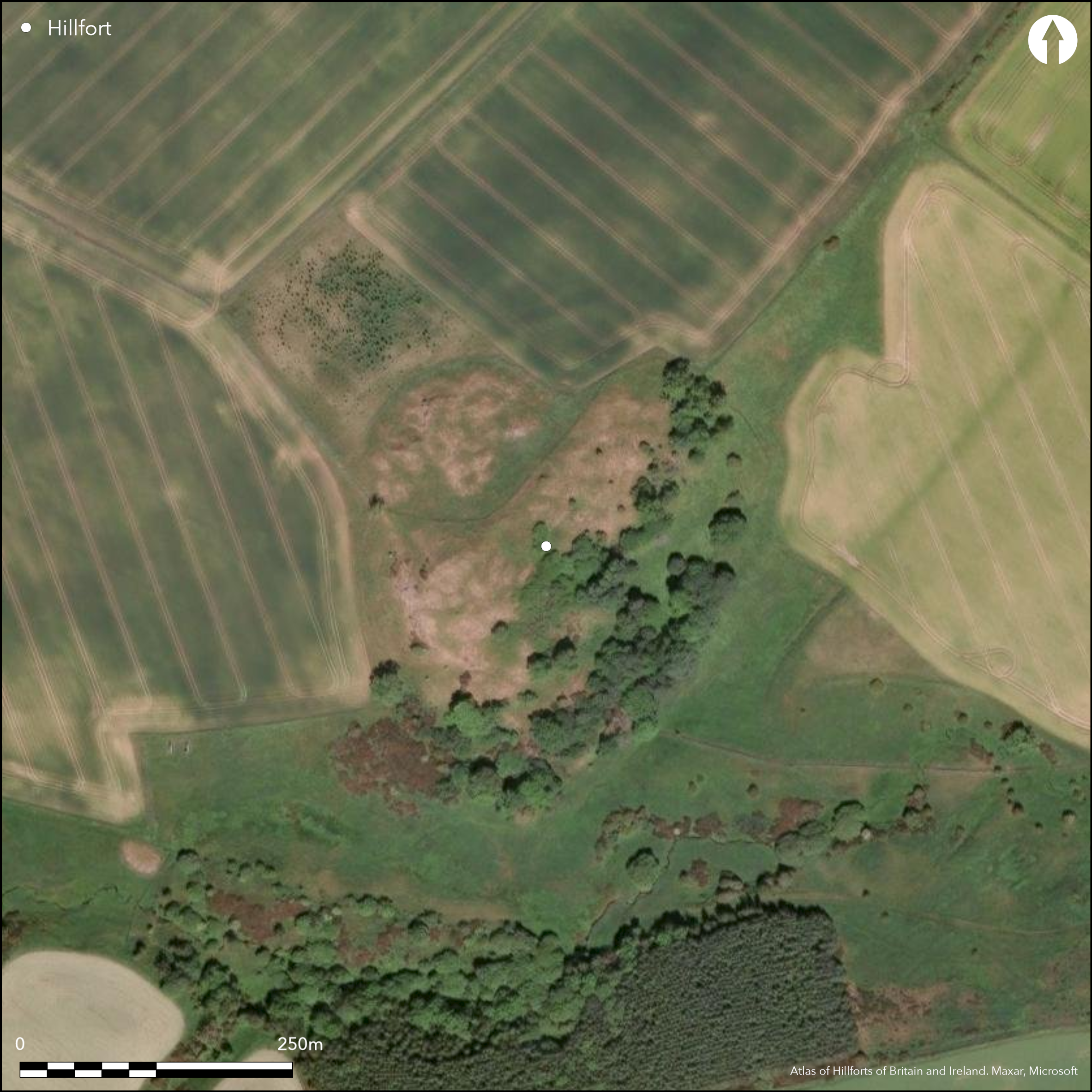
Satellite Imagery
Satellite Imagery
HER: Scottish Borders 55456 (None)
NMR: NT 52 SE 14 (55456)
SM: None
NGR: NT 5959 2318
X: 359590 Y: 623180 (OSGB36)
What may be a fort situated on the spur overlooking the top of Chesters Glen has had a chequered history of recording, so much so that there is some doubt as to what remains visible on the ground. Omitted from the RCAHMS County Inventory, it was first noted about 1958 and subsequently planned by RCAHMS investigators in 1961, apparently comprising traces of a heavily-robbed rampart extending along the edge of the crag and linking up outcrops. In 1967 the OS detected only vague traces of a rampart, which they regarded as too slight to appear on the 1:2500 scale map, and a subsequent visit in 1993 by RCAHMS investigators found the site under long grass and, while noting extensive evidence of quarrying on the outcrop, did not locate the rampart. As planned in 1961 (RCAHMS RXD 315/1; DC31519-21), it comprises three contiguous enclosures occupying the rectilinear summit area of the outcrops and a slightly lower terrace on the NE and enclosing a total area measuring about 150m from NE to SW by 30m transversely, with traces of another enclosure taking in a patch of rough ground to the NW and others taking in a terrace on the slope below the summit area on the SE. These latter, which were examined by the OS, were dismissed by other RCAHMS investigators in 1993; they considered the principal feature crossing NE end of the the terrace to be no more than the revetment of an old dyke. The seven platforms in the rough ground to the NW were thought to be surface quarries and fortuitous scarps. Whether any of these features are the remains of fortifications can only be demonstrated by excavation, but cropmarks have revealed other features that suggest the presence of a much larger fort occupying the spur. Its defences comprise a ditch about 4m in breadth, which springs from the edge of the escarpment on the NE and extends westwards in a broad arc to peter out at the edge of the field on the NW. The area enclosed against the scarp edge is roughly D-shaped on plan and measures about 220m from NE to SW along the chord by at least 130m transversely, not only taking in the enclosures on the summit of the outcrops, but also the rough ground on the NW. Apart from the enclosures on the summit, the only features visible within the interior are an angle of ditch about 6m broad, which forms an enclosure in the angle between the rough ground and the outcrops and measures internally about 50m from NE to SW by 45m transversely; traces of other enclosure ditches lie immediately to its NW.
Citizen Science: ✗
Reliability of Data: Unconfirmed
Reliability of Interpretation: Confirmed
X: -294023 Y: 7459665 (EPSG: 3857)
Longitude: -2.641255830445865 Latitude: 55.50075367381754 (EPSG:4326)
Country: Scotland
Current County or Unitary Authority: Scottish Borders
Historic County: Roxburghshire
Current Parish/Community/Council/Townland: Ancrum
None
| Extant | ✓ |
| Cropmark | ✓ |
| Likely Destroyed | ✗ |
None
| Woodland | ✓ |
| Commercial Forestry Plantation | ✗ |
| Parkland | ✗ |
| Pasture (Grazing) | ✓ |
| Arable | ✓ |
| Scrub/Bracken | ✓ |
| Bare Outcrop | ✗ |
| Heather/Moorland | ✗ |
| Heath | ✗ |
| Built-up | ✗ |
| Coastal Grassland | ✗ |
| Other | ✗ |
None
| Contour Fort | ✓ |
| Partial Contour Fort | ✗ |
| Promontory Fort | ✗ |
| Hillslope Fort | ✗ |
| Level Terrain Fort | ✗ |
| Marsh Fort | ✗ |
| Multiple Enclosure Fort | ✗ |
| Hilltop | ✗ |
| Coastal Promontory | ✗ |
| Inland Promontory | ✗ |
| Valley Bottom | ✗ |
| Knoll/Hillock/Outcrop | ✗ |
| Ridge | ✗ |
| Cliff/Plateau-edge/Scarp | ✗ |
| Hillslope | ✗ |
| Lowland | ✗ |
| Spur | ✓ |
Dominant Topographic Feature: None
| North | ✗ |
| Northeast | ✗ |
| East | ✗ |
| Southeast | ✗ |
| South | ✗ |
| Southwest | ✗ |
| West | ✗ |
| Northwest | ✗ |
| Level | ✓ |
Altitude: 194.0m
N/A
In the absence of excavation, there are neither stratified artefacts nor radiocarbon dates to provide a chronology for the defences.
Reliability: D - None
| Pre 1200BC | ✗ |
| 1200BC - 800BC | ✗ |
| 800BC - 400BC | ✗ |
| 400BC - AD50 | ✗ |
| AD50 - AD400 | ✗ |
| AD400 - AD 800 | ✗ |
| Post AD800 | ✗ |
| Unknown | ✓ |
| Pre Hillfort: | None |
| Post Hillfort: | Outer elements flattened by cultivation, inner heavily distorted by quarrying |
None
| 1st Identified Written Reference (1958): | Notified to RCAHMS by Mr G O Wood of Denholm (Wood 1961, 9; 1967, 31; RCAHMS DC11877) |
| Earthwork Survey (1961): | Plan and description (RCAHMS RXD 315/1, DC 31519-21) |
| Other (1967): | Visited by the OS |
| Other (1993): | Visited by RCAHMS |
| Other (1995): | Outlying ditch photographed by RCAHMS Aerial Survey Programme |
Seven shallow platforms first noted by RCAHMS in 1961 were regarded as surface quarries by the OS, and fortuitous scarps by later RCAHMS investigators
None
| None | ✓ |
| Spring | ✗ |
| Stream | ✗ |
| Pool | ✗ |
| Flush | ✗ |
| Well | ✗ |
| Other | ✗ |
Uncertain
| No Known Features | ✗ |
| Round Stone Structures | ✗ |
| Rectangular Stone Structures | ✗ |
| Curvilinear Platforms | ✓ |
| Other Roundhouse Evidence | ✗ |
| Pits | ✗ |
| Quarry Hollows | ✗ |
| Other | ✗ |
None
| No Known Excavation | ✓ |
| Pits | ✗ |
| Postholes | ✗ |
| Roundhouses | ✗ |
| Rectangular Structures | ✗ |
| Roads/Tracks | ✗ |
| Quarry Hollows | ✗ |
| Other | ✗ |
| Nothing Found | ✗ |
None
| No Known Geophysics | ✓ |
| Pits | ✗ |
| Roundhouses | ✗ |
| Rectangular Structures | ✗ |
| Roads/Tracks | ✗ |
| Quarry Hollows | ✗ |
| Other | ✗ |
| Nothing Found | ✗ |
None
| No Known Finds | ✓ |
| Pottery | ✗ |
| Metal | ✗ |
| Metalworking | ✗ |
| Human Bones | ✗ |
| Animal Bones | ✗ |
| Lithics | ✗ |
| Environmental | ✗ |
| Other | ✗ |
NO APPARENT FEATURES
| APs Not Checked | ✗ |
| None | ✓ |
| Roundhouses | ✗ |
| Rectangular Structures | ✗ |
| Pits | ✗ |
| Postholes | ✗ |
| Roads/Tracks | ✗ |
| Other | ✗ |
See main summary
| 0: | None |
| 2: | None known |
Guard Chambers: ✗
Chevaux de Frise: ✗
Single ditch, presumably flanked by an upcast rampart forming a D-shaped enclosure backing onto the escarpment on the SE
| Area 1: | 2.2ha. |
| Total: | 2.2ha. |
Total Footprint Area: Noneha.
None
| ✗ | None |
| ✓ | None |
| NE Quadrant: | 1 |
| SE Quadrant: | 1 |
| SW Quadrant: | 1 |
| NW Quadrant: | 1 |
| Total: | 1 |
| Partial Univallate | ✗ |
| Univallate | ✓ |
| Partial Bivallate | ✗ |
| Bivallate | ✗ |
| Partial Multivallate | ✗ |
| Multivallate | ✗ |
| Unknown | ✗ |
| Partial Univallate | ✗ |
| Univallate | ✗ |
| Partial Bivallate | ✗ |
| Bivallate | ✗ |
| Partial Multivallate | ✗ |
| Multivallate | ✗ |
None
| None | ✗ |
| Earthen Bank | ✗ |
| Stone Wall | ✓ |
| Rubble | ✗ |
| Wall-walk | ✗ |
| Evidence of Timber | ✗ |
| Vitrification | ✗ |
| Other Burning | ✗ |
| Palisade | ✗ |
| Counter Scarp Bank | ✗ |
| Berm | ✗ |
| Unfinished | ✗ |
| Other | ✗ |
None
| None | ✗ |
| Earthen Bank | ✗ |
| Stone Wall | ✗ |
| Murus Duplex | ✗ |
| Timber-framed | ✗ |
| Timber-laced | ✗ |
| Vitrification | ✗ |
| Other Burning | ✗ |
| Palisade | ✗ |
| Counter Scarp Bank | ✗ |
| Berm | ✗ |
| Unfinished | ✗ |
| No Known Excavation | ✓ |
| Other | ✗ |
| ✗ | None |
| ✓ | None |
Number of Ditches: 1
| ✗ | None |
Wood, G O (1961) 'Record of archaeological discovery in Western Roxburghshire'. Trans Hawick Archaeol Soc (1961), 9
Wood, G O (1967) 'Field section report'. Trans Hawick Archaeol Soc (1967), 31
Atlas of Hillforts:
Wikidata:
This work is licensed under CC BY-SA 4.0

 and should be cited as:
Lock, Gary and Ralston, Ian. 2024. Atlas of Hillforts of Britain and Ireland. Available at: https://hillforts.arch.ox.ac.uk
Document Version 1.1