Satellite Imagery
Satellite Imagery
HER: Scottish Borders 59032 (None)
NMR: NT 81 NW 11 (59032)
SM: 1691
NGR: NT 8288 1918
X: 382880 Y: 619180 (OSGB36)
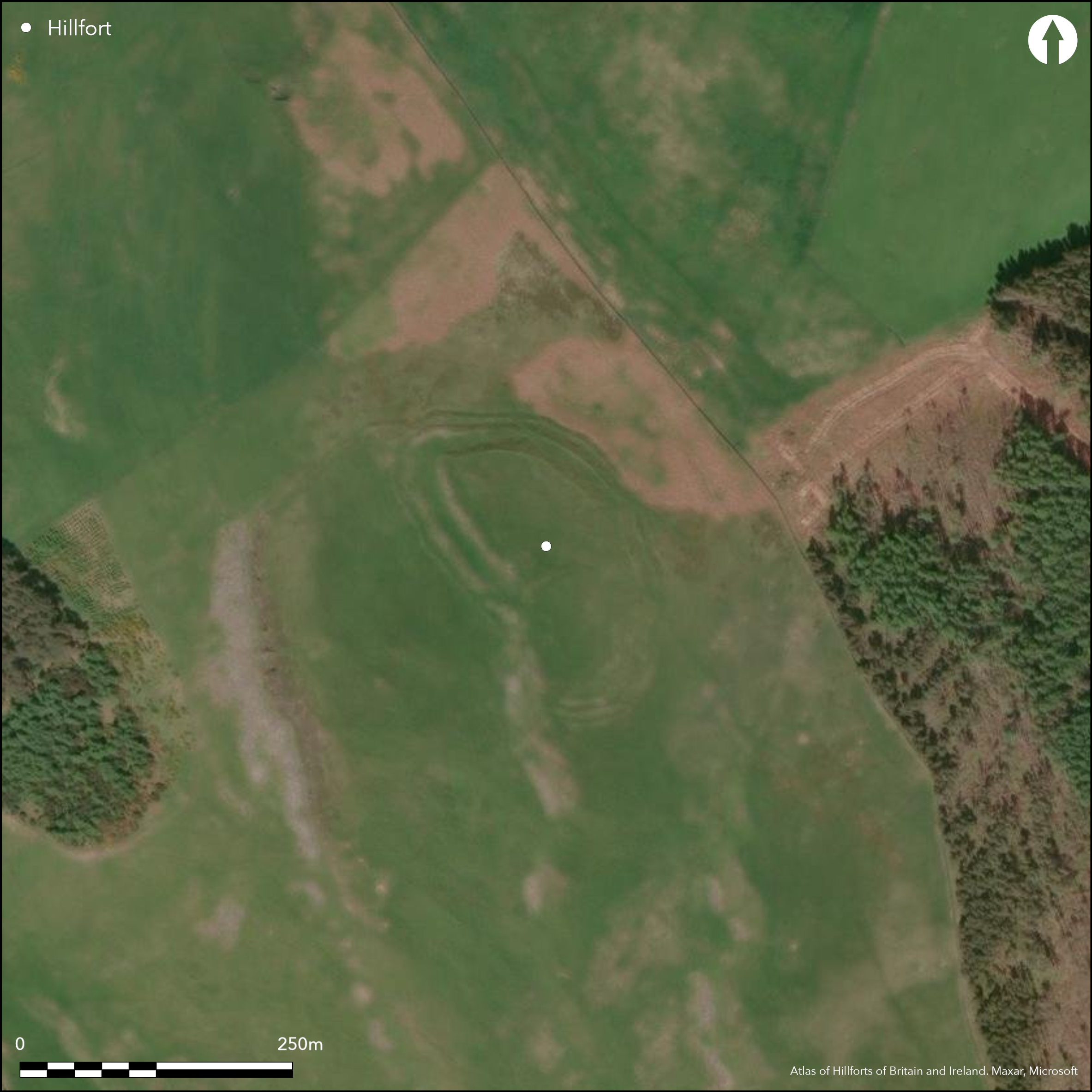
The fort known as The Castles occupies the summit of a long spur dropping down NW from Crock Law and presents a complex array of defences which have been heavily robbed and distorted by later activity. The sequence of fortification is not fully understood, the defences essentially breaking down into two discrete components, namely a univallate summit enclosure and a multivallate outer enclosure taking in a larger area on the S. The summit enclosure is roughly oval and measures about 75m from NW to SE by 50m transversely (0.31ha) within a rampart about 3m in thickness. The height of the rampart has been enhanced by external scarping, while on the SW flank it adopts the crest of the outcrops to similar effect. By comparison the SE flank appears relatively weak, but this sector has been heavily disturbed by stone robbing and the construction of what may be a later settlement enclosure. The multivallate defences encircle the inner work lower down the slope, extending S down the crest of the spur and leading Roger Mercer in 1985 to speculate that, while the sequence is unknown, a primary fort had already been expanded on this side. Be that as it may, these outer defences comprise two ramparts and intermediate ditches, the outer with intermittent traces of a counterscarp bank, forming a belt up to 15m deep. Including the area of the summit enclosure, in this period of fortification the defences enclosed a D-shaped area measuring 160m along the chord from NW to SE by 80m transversely (1ha) and was served by entrances on the E, SE, WSW and NW, this last and that on the E also giving access to entrances into the summit enclosure. The entrance on the WSW is notable for the way the ramparts return and unite around the terminals of the ditches to to either side of the gap. Within the interior of the summit enclosure, and mainly disposed on its NE side, Mercer noted at least fourteen house platforms, while on the S side he recorded a ring-groove house. The S end of the outer fort is probably overlain by a settlement enclosure, on the S side of which there are a series of enclosed yards. In addition to the defences, a ditch and bank broken by a broad entrance causeway extend down the slope from the NW apex of the fort to the lip of Castle Craigs, while at its E end it crosses the counterscarp bank and the outer ditch to rest on the middle rampart. This has been described by RCAHMS investigators in 1949 as a device to restrict access to the NW entrance of the fort, and by Mercer as an annexe enclosure, but these interpretations have failed to recognise that a bank also dismounts from the middle rampart at the SE entrance, indicating that at some point, probably in the post medieval period, the perimeter of the fort was incorporated into a land boundary.
Citizen Science: ✗
Reliability of Data: Confirmed
Reliability of Interpretation: Confirmed
X: -252954 Y: 7452874 (EPSG: 3857)
Longitude: -2.27232504566295 Latitude: 55.466186980932875 (EPSG:4326)
Country: Scotland
Current County or Unitary Authority: Scottish Borders
Historic County: Roxburghshire
Current Parish/Community/Council/Townland: Morebattle
None
| Extant | ✓ |
| Cropmark | ✗ |
| Likely Destroyed | ✗ |
None
| Woodland | ✗ |
| Commercial Forestry Plantation | ✗ |
| Parkland | ✗ |
| Pasture (Grazing) | ✓ |
| Arable | ✗ |
| Scrub/Bracken | ✗ |
| Bare Outcrop | ✗ |
| Heather/Moorland | ✓ |
| Heath | ✗ |
| Built-up | ✗ |
| Coastal Grassland | ✗ |
| Other | ✗ |
None
| Contour Fort | ✓ |
| Partial Contour Fort | ✗ |
| Promontory Fort | ✗ |
| Hillslope Fort | ✗ |
| Level Terrain Fort | ✗ |
| Marsh Fort | ✗ |
| Multiple Enclosure Fort | ✓ |
| Hilltop | ✓ |
| Coastal Promontory | ✗ |
| Inland Promontory | ✗ |
| Valley Bottom | ✗ |
| Knoll/Hillock/Outcrop | ✗ |
| Ridge | ✗ |
| Cliff/Plateau-edge/Scarp | ✗ |
| Hillslope | ✗ |
| Lowland | ✗ |
| Spur | ✗ |
Dominant Topographic Feature: None
| North | ✗ |
| Northeast | ✗ |
| East | ✗ |
| Southeast | ✗ |
| South | ✗ |
| Southwest | ✗ |
| West | ✗ |
| Northwest | ✗ |
| Level | ✓ |
Altitude: 349.0m
N/A
In the absence of excavation, there are neither stratified artefacts nor radiocarbon dates to provide a chronology for the defences.
Reliability: D - None
| Pre 1200BC | ✗ |
| 1200BC - 800BC | ✗ |
| 800BC - 400BC | ✗ |
| 400BC - AD50 | ✗ |
| AD50 - AD400 | ✗ |
| AD400 - AD 800 | ✗ |
| Post AD800 | ✗ |
| Unknown | ✓ |
| Pre Hillfort: | Stone axe (Ferguson 1897, 151) |
| Post Hillfort: | None |
Photographed from the air by Dennis Harding in 1982 and 1983, by CUCAP in 1945, and by RCAHMS Aerial Survey Programme in 1994, 2000 and 2010
| 1st Identified Map Depiction (1859): | Annotated Camp on the 1st edition OS 6-inch map (Roxburghshire 1863, sheet 23) |
| Other (1884): | Noted (Geikie 1884, 140) |
| Earthwork Survey (1897): | Plan and description by Francis Lynn (1898, 189, pl vi) |
| Earthwork Survey (1948): | Plan and description (RCAHMS 1956, 333-5, no.651, fig 439; RCAHMS RXD 154/1 -4) |
| Other (1958): | Scheduled |
| Other (1960): | Visited by the OS |
| Other (1968): | Surveyed at 1:2500 by the OS |
| Other (1976): | Visited by the OS |
| Earthwork Survey (1985): | Plan and description by Roger Mercer (RCAHMS MS2598, DC15909, DC15920, DC15922, DC15924-30, DC48746, DC48750, DC48755; overall plan DC48794 & DP100529) |
At least fourteen house platforms, a ring-groove, and a series of later yards.
None
| None | ✓ |
| Spring | ✗ |
| Stream | ✗ |
| Pool | ✗ |
| Flush | ✗ |
| Well | ✗ |
| Other | ✗ |
Ring-groove. Later yards
| No Known Features | ✗ |
| Round Stone Structures | ✗ |
| Rectangular Stone Structures | ✗ |
| Curvilinear Platforms | ✓ |
| Other Roundhouse Evidence | ✓ |
| Pits | ✗ |
| Quarry Hollows | ✗ |
| Other | ✓ |
None
| No Known Excavation | ✓ |
| Pits | ✗ |
| Postholes | ✗ |
| Roundhouses | ✗ |
| Rectangular Structures | ✗ |
| Roads/Tracks | ✗ |
| Quarry Hollows | ✗ |
| Other | ✗ |
| Nothing Found | ✗ |
None
| No Known Geophysics | ✓ |
| Pits | ✗ |
| Roundhouses | ✗ |
| Rectangular Structures | ✗ |
| Roads/Tracks | ✗ |
| Quarry Hollows | ✗ |
| Other | ✗ |
| Nothing Found | ✗ |
None
| No Known Finds | ✓ |
| Pottery | ✗ |
| Metal | ✗ |
| Metalworking | ✗ |
| Human Bones | ✗ |
| Animal Bones | ✗ |
| Lithics | ✗ |
| Environmental | ✗ |
| Other | ✗ |
Later yards
| APs Not Checked | ✗ |
| None | ✗ |
| Roundhouses | ✓ |
| Rectangular Structures | ✗ |
| Pits | ✗ |
| Postholes | ✗ |
| Roads/Tracks | ✗ |
| Other | ✓ |
See main summary
| 5: | A gap on the N is probably of relatively recent date |
| 2: | None |
Guard Chambers: ✗
Chevaux de Frise: ✗
| 1. Oblique (East): | The entrance way approaches obliquely to expose the visitor's left side and gives access to the entrance into the inner enclosure on the summit |
| 1. Simple Gap (East): | None |
| 2. Simple Gap (South east): | None |
| 3. Passage-way/Corridor (South west): | The ramparts return and unite to either side of the gap |
| 4. Simple Gap (North west): | Gives access to the entrance into the inner enclosure on the summit |
Two discrete enclosures, the inner on the summit bounded by a single rampart, and the outer by two ramparts and ditches, the outer with a counterscarp bank
| Area 1: | 0.31ha. |
| Area 2: | 1.0ha. |
| Total: | 1.0ha. |
Total Footprint Area: Noneha.
None
| ✗ | None |
| ✓ | Conflates two periods of construction |
| NE Quadrant: | 3 |
| SE Quadrant: | 2 |
| SW Quadrant: | 2 |
| NW Quadrant: | 3 |
| Total: | 3 |
| Partial Univallate | ✗ |
| Univallate | ✗ |
| Partial Bivallate | ✓ |
| Bivallate | ✗ |
| Partial Multivallate | ✓ |
| Multivallate | ✗ |
| Unknown | ✗ |
| Partial Univallate | ✗ |
| Univallate | ✓ |
| Partial Bivallate | ✗ |
| Bivallate | ✓ |
| Partial Multivallate | ✗ |
| Multivallate | ✗ |
None
| None | ✗ |
| Earthen Bank | ✓ |
| Stone Wall | ✓ |
| Rubble | ✗ |
| Wall-walk | ✗ |
| Evidence of Timber | ✗ |
| Vitrification | ✗ |
| Other Burning | ✗ |
| Palisade | ✗ |
| Counter Scarp Bank | ✓ |
| Berm | ✗ |
| Unfinished | ✗ |
| Other | ✗ |
None
| None | ✗ |
| Earthen Bank | ✗ |
| Stone Wall | ✗ |
| Murus Duplex | ✗ |
| Timber-framed | ✗ |
| Timber-laced | ✗ |
| Vitrification | ✗ |
| Other Burning | ✗ |
| Palisade | ✗ |
| Counter Scarp Bank | ✗ |
| Berm | ✗ |
| Unfinished | ✗ |
| No Known Excavation | ✓ |
| Other | ✗ |
| ✗ | None |
| ✓ | None |
Number of Ditches: 2
| ✗ | None |
Ferguson, J (The President) (1898) 'Report of the Meetings for 1897; Kelso for Head of Bowmont Water'. Hist Berwickshire Natur Club 16 (1896-8),
Lynn, F (1898) 'The heads of Bowmont Water'. Hist Berwickshire Natur Club 16 (1896-8), 185-200
RCAHMS (1956) The Royal Commission on the Ancient and Historical Monuments of Scotland. An inventory of the ancient and historical monuments of Roxburghshire: with the fourteenth report of the Commission, 2v. HMSO: Edinburgh
Atlas of Hillforts:
Wikidata:
This work is licensed under CC BY-SA 4.0

 and should be cited as:
Lock, Gary and Ralston, Ian. 2024. Atlas of Hillforts of Britain and Ireland. Available at: https://hillforts.arch.ox.ac.uk
Document Version 1.1