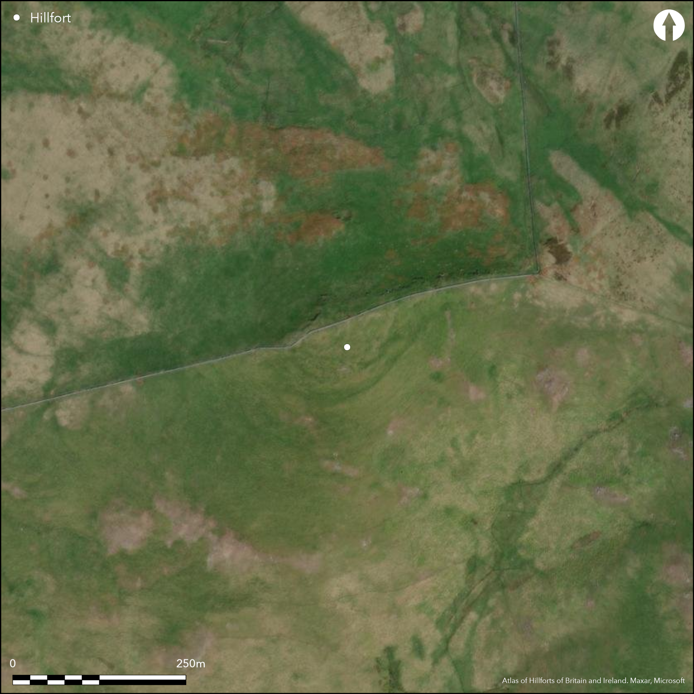
Satellite Imagery
Satellite Imagery
HER: Scottish Borders 59255 (None)
NMR: NT 82 NE 78 (59255)
SM: None
NGR: NT 8522 2617
X: 385220 Y: 626170 (OSGB36)
The remains of a a fort are situated on the summit of the W spur of White Law, immediately W of Whitelaw Nick, which marks the position of the border line between England and Scotland. First identified in 1947 by RCAHMS investigators from vertical aerial photographs, they were able to trace the two ramparts only around the S side of the rocky spine of the spur, but nevertheless projected the rampart symmetrically around the foot of the rocks on the N, assigning internal measurements of a little over 105m from ENE to WSW by 75m transversely (0.6ha). While has been no follow-up fieldwork to contradict this assessment, satellite imagery suggests that they overestimated its size, both in length and breadth, and that the true measurements are closer to 90m in length by 60m in breadth (0.44ha), though the course of the two ramparts on the N flank remains uncertain. Elsewhere they are both reduced to scarps extending round the contour about 8m apart and broken by an entrance on the E facing onto the easiest line of approach from Whitelaw Nick; the gaps through the two ramparts are not directly opposed to each other but staggered so as to expose the visitor's right side. While the RCAHMS investigators identified several irregular platforms on the slope between the dyke that traverses the spur along the axis of the fort and the ramparts on the S as possible house-platforms, the satellite imagery reveals traces of at least five timber round-houses defined by shallow grooves or ditches.
Citizen Science: ✗
Reliability of Data: Confirmed
Reliability of Interpretation: Confirmed
X: -248876 Y: 7465233 (EPSG: 3857)
Longitude: -2.235689652606994 Latitude: 55.52907255117476 (EPSG:4326)
Country: Scotland
Current County or Unitary Authority: Scottish Borders
Historic County: Roxburghshire
Current Parish/Community/Council/Townland: Yetholm
None
| Extant | ✓ |
| Cropmark | ✗ |
| Likely Destroyed | ✗ |
None
| Woodland | ✗ |
| Commercial Forestry Plantation | ✗ |
| Parkland | ✗ |
| Pasture (Grazing) | ✓ |
| Arable | ✗ |
| Scrub/Bracken | ✗ |
| Bare Outcrop | ✗ |
| Heather/Moorland | ✓ |
| Heath | ✗ |
| Built-up | ✗ |
| Coastal Grassland | ✗ |
| Other | ✗ |
None
| Contour Fort | ✓ |
| Partial Contour Fort | ✗ |
| Promontory Fort | ✗ |
| Hillslope Fort | ✗ |
| Level Terrain Fort | ✗ |
| Marsh Fort | ✗ |
| Multiple Enclosure Fort | ✗ |
| Hilltop | ✓ |
| Coastal Promontory | ✗ |
| Inland Promontory | ✗ |
| Valley Bottom | ✗ |
| Knoll/Hillock/Outcrop | ✗ |
| Ridge | ✗ |
| Cliff/Plateau-edge/Scarp | ✗ |
| Hillslope | ✗ |
| Lowland | ✗ |
| Spur | ✗ |
Dominant Topographic Feature: None
| North | ✗ |
| Northeast | ✗ |
| East | ✗ |
| Southeast | ✗ |
| South | ✗ |
| Southwest | ✗ |
| West | ✗ |
| Northwest | ✗ |
| Level | ✓ |
Altitude: 410.0m
N/A
In the absence of excavation, there are neither stratified artefacts nor radiocarbon dates to provide a chronology for the defences.
Reliability: D - None
| Pre 1200BC | ✗ |
| 1200BC - 800BC | ✗ |
| 800BC - 400BC | ✗ |
| 400BC - AD50 | ✗ |
| AD50 - AD400 | ✗ |
| AD400 - AD 800 | ✗ |
| Post AD800 | ✗ |
| Unknown | ✓ |
| Pre Hillfort: | None |
| Post Hillfort: | Overlain by a stone dyke |
None
| 1st Identified Written Reference (1947): | Description after discovery on vertical aerial photographs (RCAHMS 1956, 456, no.1043) |
| 1st Identified Map Depiction (1978): | Surveyed at 1:10,000 by the OS |
Rough platforms identified by RCAHMS investigators in 1947 are clearly revealed by satellite images as timber round houses with associated grooves and ditches.
None
| None | ✓ |
| Spring | ✗ |
| Stream | ✗ |
| Pool | ✗ |
| Flush | ✗ |
| Well | ✗ |
| Other | ✗ |
Ring-groove or ring-ditch houses
| No Known Features | ✗ |
| Round Stone Structures | ✗ |
| Rectangular Stone Structures | ✗ |
| Curvilinear Platforms | ✓ |
| Other Roundhouse Evidence | ✓ |
| Pits | ✗ |
| Quarry Hollows | ✗ |
| Other | ✗ |
None
| No Known Excavation | ✓ |
| Pits | ✗ |
| Postholes | ✗ |
| Roundhouses | ✗ |
| Rectangular Structures | ✗ |
| Roads/Tracks | ✗ |
| Quarry Hollows | ✗ |
| Other | ✗ |
| Nothing Found | ✗ |
None
| No Known Geophysics | ✓ |
| Pits | ✗ |
| Roundhouses | ✗ |
| Rectangular Structures | ✗ |
| Roads/Tracks | ✗ |
| Quarry Hollows | ✗ |
| Other | ✗ |
| Nothing Found | ✗ |
None
| No Known Finds | ✓ |
| Pottery | ✗ |
| Metal | ✗ |
| Metalworking | ✗ |
| Human Bones | ✗ |
| Animal Bones | ✗ |
| Lithics | ✗ |
| Environmental | ✗ |
| Other | ✗ |
None
| APs Not Checked | ✗ |
| None | ✗ |
| Roundhouses | ✓ |
| Rectangular Structures | ✗ |
| Pits | ✗ |
| Postholes | ✗ |
| Roads/Tracks | ✗ |
| Other | ✗ |
See main summary
| 1: | None |
| 2: | None |
Guard Chambers: ✗
Chevaux de Frise: ✗
| 1. Oblique (East): | Staggered gaps. Oblique approach exposing right side. |
Two ramparts are traceable around one side
| Area 1: | 0.44ha. |
| Total: | 0.44ha. |
Total Footprint Area: Noneha.
None
| ✗ | None |
| ✗ | None |
| NE Quadrant: | 0 |
| SE Quadrant: | 2 |
| SW Quadrant: | 2 |
| NW Quadrant: | 0 |
| Total: | 2 |
| Partial Univallate | ✗ |
| Univallate | ✗ |
| Partial Bivallate | ✓ |
| Bivallate | ✗ |
| Partial Multivallate | ✗ |
| Multivallate | ✗ |
| Unknown | ✗ |
| Partial Univallate | ✗ |
| Univallate | ✗ |
| Partial Bivallate | ✗ |
| Bivallate | ✗ |
| Partial Multivallate | ✗ |
| Multivallate | ✗ |
Grass-grown scarps
| None | ✗ |
| Earthen Bank | ✓ |
| Stone Wall | ✗ |
| Rubble | ✗ |
| Wall-walk | ✗ |
| Evidence of Timber | ✗ |
| Vitrification | ✗ |
| Other Burning | ✗ |
| Palisade | ✗ |
| Counter Scarp Bank | ✗ |
| Berm | ✗ |
| Unfinished | ✗ |
| Other | ✗ |
None
| None | ✗ |
| Earthen Bank | ✗ |
| Stone Wall | ✗ |
| Murus Duplex | ✗ |
| Timber-framed | ✗ |
| Timber-laced | ✗ |
| Vitrification | ✗ |
| Other Burning | ✗ |
| Palisade | ✗ |
| Counter Scarp Bank | ✗ |
| Berm | ✗ |
| Unfinished | ✗ |
| No Known Excavation | ✓ |
| Other | ✗ |
| ✗ | None |
| ✗ | None |
Number of Ditches: None
| ✗ | None |
RCAHMS (1956) The Royal Commission on the Ancient and Historical Monuments of Scotland. An inventory of the ancient and historical monuments of Roxburghshire: with the fourteenth report of the Commission, 2v. HMSO: Edinburgh
Atlas of Hillforts:
Wikidata:
This work is licensed under CC BY-SA 4.0

 and should be cited as:
Lock, Gary and Ralston, Ian. 2024. Atlas of Hillforts of Britain and Ireland. Available at: https://hillforts.arch.ox.ac.uk
Document Version 1.1