Satellite Imagery
Satellite Imagery
HER: Scottish Borders 59403 (None)
NMR: NT 82 SW 8 (59403)
SM: 1698
NGR: NT 8476 2135
X: 384768 Y: 621350 (OSGB36)
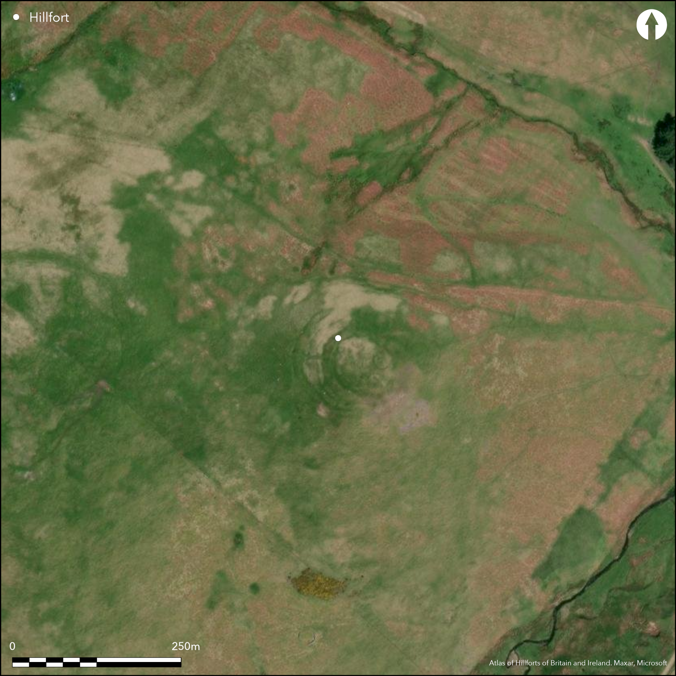
This fort is situated on Kip Knowe, a rocky hillock rising out of the steep E flank of Hairny Law. It is almost circular on plan, measuring internally about 55m from NW to SE by 50m transversely (0.21ha), but the defences do not encircle the whole hillock, forming a belt from between 25m and 30m deep across the easiest lines of approach around the NW half of the circuit, but petering out as the slopes get progressively steeper on the S and NE slopes, and disappearing entirely on the steepest slopes on the SE. The innermost of the ramparts, which is flanked by an internal quarry, stands little more than 0.8m high internally, but falls away externally some 2.3m into the bottom of a ragged external ditch with traces of a counterscarp bank. The medial rampart forms a bank 5m thick by 1m high and is again accompanied intermittently by a ragged external ditch, as is the outermost rampart; it is unclear whether the three ramparts are all contemporary. The RCAHMS investigators in 1947 postulated two entrances, one on the NE with a clearly defined worn passage dropping down the slope, and the other where the ramparts peter out on the the S, but a more recent survey by Roger Mercer was unconvinced by the second and speculated that another gap in the innermost rampart on the N was possibly an earlier entrance blocked by the addition of the later ramparts; the latter is equally unconvincing, though the intercutting timber round-house stances in the interior raise the possibility that occupation and alteration of the ramparts may have taken place after the defences fell derelict. In all the stances of at least eleven round-houses can be seen within the interior, mainly comprising shallow platforms encircled by shallow grooves and banks. These evidently represent several periods of construction, and one on the NW is not only set into the internal quarry behind the innermost rampart, but also probably cuts the rampart itself.
Citizen Science: ✗
Reliability of Data: Confirmed
Reliability of Interpretation: Confirmed
X: -249643 Y: 7456716 (EPSG: 3857)
Longitude: -2.242583575625601 Latitude: 55.485748418242416 (EPSG:4326)
Country: Scotland
Current County or Unitary Authority: Scottish Borders
Historic County: Roxburghshire
Current Parish/Community/Council/Townland: Morebattle
None
| Extant | ✓ |
| Cropmark | ✗ |
| Likely Destroyed | ✗ |
None
| Woodland | ✗ |
| Commercial Forestry Plantation | ✗ |
| Parkland | ✓ |
| Pasture (Grazing) | ✗ |
| Arable | ✗ |
| Scrub/Bracken | ✗ |
| Bare Outcrop | ✗ |
| Heather/Moorland | ✓ |
| Heath | ✗ |
| Built-up | ✗ |
| Coastal Grassland | ✗ |
| Other | ✗ |
None
| Contour Fort | ✓ |
| Partial Contour Fort | ✗ |
| Promontory Fort | ✗ |
| Hillslope Fort | ✗ |
| Level Terrain Fort | ✗ |
| Marsh Fort | ✗ |
| Multiple Enclosure Fort | ✗ |
| Hilltop | ✓ |
| Coastal Promontory | ✗ |
| Inland Promontory | ✗ |
| Valley Bottom | ✗ |
| Knoll/Hillock/Outcrop | ✗ |
| Ridge | ✗ |
| Cliff/Plateau-edge/Scarp | ✗ |
| Hillslope | ✗ |
| Lowland | ✗ |
| Spur | ✗ |
Dominant Topographic Feature: None
| North | ✗ |
| Northeast | ✗ |
| East | ✗ |
| Southeast | ✗ |
| South | ✗ |
| Southwest | ✗ |
| West | ✗ |
| Northwest | ✗ |
| Level | ✓ |
Altitude: 356.0m
N/A
In the absence of excavation, there are neither stratified artefacts nor radiocarbon dates to provide a chronology for the defences.
Reliability: D - None
| Pre 1200BC | ✗ |
| 1200BC - 800BC | ✗ |
| 800BC - 400BC | ✗ |
| 400BC - AD50 | ✗ |
| AD50 - AD400 | ✗ |
| AD400 - AD 800 | ✗ |
| Post AD800 | ✗ |
| Unknown | ✓ |
| Pre Hillfort: | None |
| Post Hillfort: | Defences overridden by a later field-bank |
Aerial photographs taken by Dennis Harding in 1982 and 1983, and RCAHMS Aerial Survey Programme in 1992
| 1st Identified Map Depiction (1859): | Annotated Camp on the 1st edition OS 25-inch map (Rocburgh 1863, sheet, 23.1) |
| Other (1884): | Noted (Geikie 1884, 142) |
| Other (1897): | Description provided to Francis Lynn by a friend (1898, 191-2) |
| Earthwork Survey (1947): | Plan and description (RCAHMS 1956, 331, no.649, fig 437; RCAHMS RXD 152/1-2) |
| Other (1960): | Visited by the OS |
| Other (1960): | Scheduled |
| Other (1976): | Resurveyed at 1:10,000 by the OS |
| Earthwork Survey (1987): | Plan and description by Roger Mercer (RCAHMS MS2598; DC16039, DC16111, DC16327, DC16448, DC16048, DC16038; overall plan DC48827 & DP100562) |
At least eleven timber round-house stances, mainly comprising shallow scoops or platforms encircled by groves and banks.
None
| None | ✓ |
| Spring | ✗ |
| Stream | ✗ |
| Pool | ✗ |
| Flush | ✗ |
| Well | ✗ |
| Other | ✗ |
Platforms within ring-grooves
| No Known Features | ✗ |
| Round Stone Structures | ✗ |
| Rectangular Stone Structures | ✗ |
| Curvilinear Platforms | ✗ |
| Other Roundhouse Evidence | ✓ |
| Pits | ✗ |
| Quarry Hollows | ✗ |
| Other | ✗ |
None
| No Known Excavation | ✓ |
| Pits | ✗ |
| Postholes | ✗ |
| Roundhouses | ✗ |
| Rectangular Structures | ✗ |
| Roads/Tracks | ✗ |
| Quarry Hollows | ✗ |
| Other | ✗ |
| Nothing Found | ✗ |
None
| No Known Geophysics | ✓ |
| Pits | ✗ |
| Roundhouses | ✗ |
| Rectangular Structures | ✗ |
| Roads/Tracks | ✗ |
| Quarry Hollows | ✗ |
| Other | ✗ |
| Nothing Found | ✗ |
None
| No Known Finds | ✓ |
| Pottery | ✗ |
| Metal | ✗ |
| Metalworking | ✗ |
| Human Bones | ✗ |
| Animal Bones | ✗ |
| Lithics | ✗ |
| Environmental | ✗ |
| Other | ✗ |
None
| APs Not Checked | ✗ |
| None | ✗ |
| Roundhouses | ✓ |
| Rectangular Structures | ✗ |
| Pits | ✗ |
| Postholes | ✗ |
| Roads/Tracks | ✗ |
| Other | ✗ |
See main summary
| 2: | None |
| 2: | None |
Guard Chambers: ✗
Chevaux de Frise: ✗
| 1. Simple Gap (North east): | None |
Three main ramparts blocking access on one side and accompanied by ragged external quarry ditches.
| Area 1: | 0.21ha. |
| Total: | 0.21ha. |
Total Footprint Area: 0.6ha.
None
| ✗ | None |
| ✗ | None |
| NE Quadrant: | 1 |
| SE Quadrant: | 0 |
| SW Quadrant: | 3 |
| NW Quadrant: | 3 |
| Total: | 3 |
| Partial Univallate | ✓ |
| Univallate | ✗ |
| Partial Bivallate | ✗ |
| Bivallate | ✗ |
| Partial Multivallate | ✓ |
| Multivallate | ✗ |
| Unknown | ✗ |
| Partial Univallate | ✗ |
| Univallate | ✗ |
| Partial Bivallate | ✗ |
| Bivallate | ✗ |
| Partial Multivallate | ✗ |
| Multivallate | ✗ |
None
| None | ✗ |
| Earthen Bank | ✓ |
| Stone Wall | ✗ |
| Rubble | ✗ |
| Wall-walk | ✗ |
| Evidence of Timber | ✗ |
| Vitrification | ✗ |
| Other Burning | ✗ |
| Palisade | ✗ |
| Counter Scarp Bank | ✓ |
| Berm | ✗ |
| Unfinished | ✗ |
| Other | ✗ |
None
| None | ✗ |
| Earthen Bank | ✗ |
| Stone Wall | ✗ |
| Murus Duplex | ✗ |
| Timber-framed | ✗ |
| Timber-laced | ✗ |
| Vitrification | ✗ |
| Other Burning | ✗ |
| Palisade | ✗ |
| Counter Scarp Bank | ✗ |
| Berm | ✗ |
| Unfinished | ✗ |
| No Known Excavation | ✓ |
| Other | ✗ |
| ✗ | None |
| ✓ | Intermittent and very ragged quarries |
Number of Ditches: 3
| ✗ | None |
Geikie, J (1884) «List of hill forts, intrenched camps, etc. in Roxburghshire on the Scotch side of the Cheviots. Hist Berwickshire Natur Club 10 (1882-4) 139-44
Lynn, F (1898) 'The heads of Bowmont Water'. Hist Berwickshire Natur Club 16 (1896-8), 185-200
RCAHMS (1956) The Royal Commission on the Ancient and Historical Monuments of Scotland. An inventory of the ancient and historical monuments of Roxburghshire: with the fourteenth report of the Commission, 2v. HMSO: Edinburgh
Atlas of Hillforts:
Wikidata:
This work is licensed under CC BY-SA 4.0

 and should be cited as:
Lock, Gary and Ralston, Ian. 2024. Atlas of Hillforts of Britain and Ireland. Available at: https://hillforts.arch.ox.ac.uk
Document Version 1.1