Satellite Imagery
Satellite Imagery
HER: Scottish Borders 54335 (None)
NMR: NT 42 SW 4 (54335)
SM: 2227
NGR: NT 4489 2188
X: 344890 Y: 621880 (OSGB36)
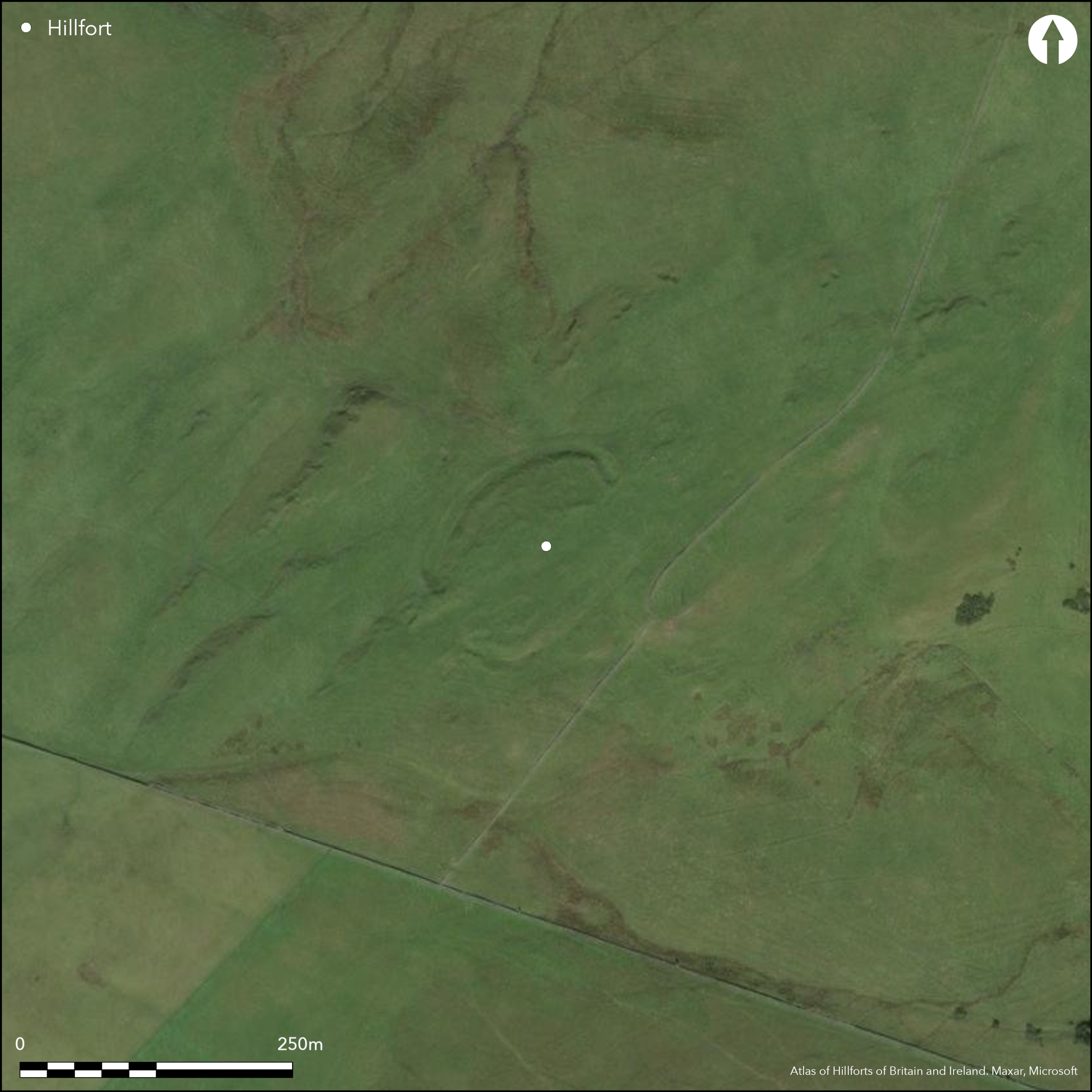
This fort is situated on the W end of the broad summit of Broadlee hill, where the ground starts rising SW towards a higher summit. Roughly oval on plan, it measures internally about 90m from NE to SW by 60m transversely (0.46ha). Its defences present rather different characteristics to either side of its axis, the NW half apparently defended by a massive ditch between 9m and 13.5m in breadth by 1.6m deep dug along the foot of a low ridge of outcrop and provided with a low rampart surviving along its counterscarp. On the NE the counterscarp rampart bank returns around the terminal of the ditch to unite with the inner rampart, which is otherwise missing, while on the SW the ditch terminates against a band of harder rock flanking what is probably a second entrance. The SE half of the defences, however, comprise two ditches with a medial rampart, and again there is very little trace of an internal rampart. The rough appearance of the SE half, coupled with the wide gaps at the entrances and the way the ditch of the NW half terminates against the band of outcrops flanking the SW entrance led RCAHMS investigators in 1950 to propose that the defences of the fort were unfinished, but they may have underestimated the extent of later robbing and disturbance. Not only are there traces of surface quarrying across the interior, but the secondary oval court they recorded on the N is probably part of a more extensive settlement of rectangular structures and yards, both within the interior and overlying the counterscarp of the outer ditch on the SE. Furthermore, despite the massive scale of the ditch on the NW, the material won from its cutting is largely missing. More likely than being unfinished, the defences are perhaps simply severely denuded, and the wide gaps at the entrances are the result of the removal of the ramparts that originally returned around the terminals of the ditches to flank the entrance passages.
Citizen Science: ✗
Reliability of Data: Confirmed
Reliability of Interpretation: Confirmed
X: -319896 Y: 7457087 (EPSG: 3857)
Longitude: -2.873678235683502 Latitude: 55.487634408118176 (EPSG:4326)
Country: Scotland
Current County or Unitary Authority: Scottish Borders
Historic County: Selkirkshire
Current Parish/Community/Council/Townland: Ashkirk
None
| Extant | ✓ |
| Cropmark | ✗ |
| Likely Destroyed | ✗ |
None
| Woodland | ✗ |
| Commercial Forestry Plantation | ✗ |
| Parkland | ✗ |
| Pasture (Grazing) | ✓ |
| Arable | ✗ |
| Scrub/Bracken | ✗ |
| Bare Outcrop | ✗ |
| Heather/Moorland | ✓ |
| Heath | ✗ |
| Built-up | ✗ |
| Coastal Grassland | ✗ |
| Other | ✗ |
None
| Contour Fort | ✓ |
| Partial Contour Fort | ✗ |
| Promontory Fort | ✗ |
| Hillslope Fort | ✗ |
| Level Terrain Fort | ✗ |
| Marsh Fort | ✗ |
| Multiple Enclosure Fort | ✗ |
| Hilltop | ✓ |
| Coastal Promontory | ✗ |
| Inland Promontory | ✗ |
| Valley Bottom | ✗ |
| Knoll/Hillock/Outcrop | ✗ |
| Ridge | ✗ |
| Cliff/Plateau-edge/Scarp | ✗ |
| Hillslope | ✗ |
| Lowland | ✗ |
| Spur | ✗ |
Dominant Topographic Feature: None
| North | ✗ |
| Northeast | ✗ |
| East | ✗ |
| Southeast | ✗ |
| South | ✗ |
| Southwest | ✗ |
| West | ✗ |
| Northwest | ✗ |
| Level | ✓ |
Altitude: 260.0m
N/A
In the absence of excavation, there are neither stratified artefacts nor radiocarbon dates to provide a chronology for the defences.
Reliability: D - None
| Pre 1200BC | ✗ |
| 1200BC - 800BC | ✗ |
| 800BC - 400BC | ✗ |
| 400BC - AD50 | ✗ |
| AD50 - AD400 | ✗ |
| AD400 - AD 800 | ✗ |
| Post AD800 | ✗ |
| Unknown | ✓ |
| Pre Hillfort: | None |
| Post Hillfort: | Overlain by later yards and structures and probably heavily quarried |
Photographed by RCAHMS Aerial Survey Programme in 1989 and 2010
| 1st Identified Map Depiction (1858): | Annotated Camp on the 1st edition OS 25-inch map (Roxburgh 1863, sheet 19.1) |
| Earthwork Survey (1950): | Plan and description (RCAHMS 1957, 97-8, no.128, fig 119; RCAHMS SED 6/1-2) |
| Other (1962): | Scheduled |
| Other (1962): | Resurveyed at 1:10,560 by the OS |
| Other (1965): | Resurveyed at 1:2500 by the OS |
Traces of surface quarrying and at least one later enclosure and a rectangular building; other enclosures and buildings outside
None
| None | ✓ |
| Spring | ✗ |
| Stream | ✗ |
| Pool | ✗ |
| Flush | ✗ |
| Well | ✗ |
| Other | ✗ |
None
| No Known Features | ✗ |
| Round Stone Structures | ✗ |
| Rectangular Stone Structures | ✓ |
| Curvilinear Platforms | ✗ |
| Other Roundhouse Evidence | ✗ |
| Pits | ✗ |
| Quarry Hollows | ✗ |
| Other | ✓ |
None
| No Known Excavation | ✓ |
| Pits | ✗ |
| Postholes | ✗ |
| Roundhouses | ✗ |
| Rectangular Structures | ✗ |
| Roads/Tracks | ✗ |
| Quarry Hollows | ✗ |
| Other | ✗ |
| Nothing Found | ✗ |
None
| No Known Geophysics | ✓ |
| Pits | ✗ |
| Roundhouses | ✗ |
| Rectangular Structures | ✗ |
| Roads/Tracks | ✗ |
| Quarry Hollows | ✗ |
| Other | ✗ |
| Nothing Found | ✗ |
None
| No Known Finds | ✓ |
| Pottery | ✗ |
| Metal | ✗ |
| Metalworking | ✗ |
| Human Bones | ✗ |
| Animal Bones | ✗ |
| Lithics | ✗ |
| Environmental | ✗ |
| Other | ✗ |
And enclosures
| APs Not Checked | ✗ |
| None | ✗ |
| Roundhouses | ✗ |
| Rectangular Structures | ✓ |
| Pits | ✗ |
| Postholes | ✗ |
| Roads/Tracks | ✗ |
| Other | ✓ |
See main summary
| 2: | None |
| 2: | None |
Guard Chambers: ✗
Chevaux de Frise: ✗
| 1. Passage-way/Corridor (North east): | Ramparts return and unite around the terminals of the ditch |
| 2. Simple Gap (South west): | None |
Probably twin ramparts with a medial ditch round one side and double ramparts with external ditches round the other
| Area 1: | 0.46ha. |
| Total: | 0.46ha. |
Total Footprint Area: 1.0ha.
None
| ✗ | None |
| ✓ | None |
| NE Quadrant: | 2 |
| SE Quadrant: | 1 |
| SW Quadrant: | 1 |
| NW Quadrant: | 1 |
| Total: | 2 |
| Partial Univallate | ✓ |
| Univallate | ✗ |
| Partial Bivallate | ✓ |
| Bivallate | ✗ |
| Partial Multivallate | ✗ |
| Multivallate | ✗ |
| Unknown | ✗ |
| Partial Univallate | ✗ |
| Univallate | ✗ |
| Partial Bivallate | ✗ |
| Bivallate | ✗ |
| Partial Multivallate | ✗ |
| Multivallate | ✗ |
Claimed as unfinished but this may be a misunderstanding of subsequent denudation
| None | ✗ |
| Earthen Bank | ✓ |
| Stone Wall | ✗ |
| Rubble | ✗ |
| Wall-walk | ✗ |
| Evidence of Timber | ✗ |
| Vitrification | ✗ |
| Other Burning | ✗ |
| Palisade | ✗ |
| Counter Scarp Bank | ✗ |
| Berm | ✗ |
| Unfinished | ✓ |
| Other | ✗ |
None
| None | ✗ |
| Earthen Bank | ✗ |
| Stone Wall | ✗ |
| Murus Duplex | ✗ |
| Timber-framed | ✗ |
| Timber-laced | ✗ |
| Vitrification | ✗ |
| Other Burning | ✗ |
| Palisade | ✗ |
| Counter Scarp Bank | ✗ |
| Berm | ✗ |
| Unfinished | ✗ |
| No Known Excavation | ✓ |
| Other | ✗ |
| ✗ | None |
| ✓ | One round one half, two round the other |
Number of Ditches: 2
| ✗ | None |
RCAHMS (1957) The Royal Commission on the Ancient and Historical Monuments of Scotland. An inventory of the ancient and historical monuments of Selkirkshire with the fifteenth report of the Commission. HMSO: Edinburgh
Atlas of Hillforts:
Wikidata:
This work is licensed under CC BY-SA 4.0

 and should be cited as:
Lock, Gary and Ralston, Ian. 2024. Atlas of Hillforts of Britain and Ireland. Available at: https://hillforts.arch.ox.ac.uk
Document Version 1.1