Satellite Imagery
Satellite Imagery
HER: Scottish Borders 49792 (None)
NMR: NT 12 NW 8 (49792)
SM: 3025
NGR: NT 1102 2975
X: 311020 Y: 629750 (OSGB36)
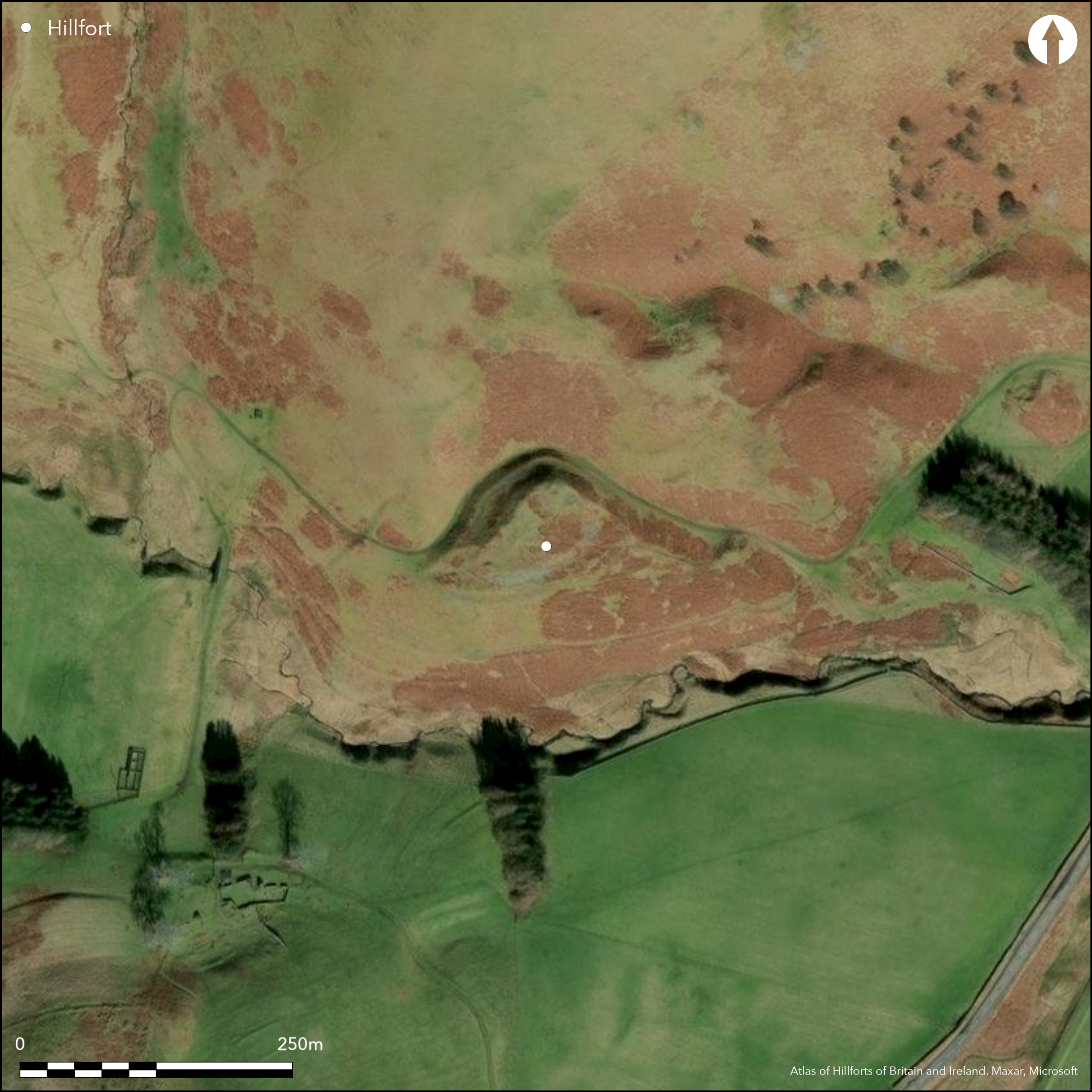
This fort occupies a steep-sided hillock that has been carved out of the southern foot of Worm Hill by a glacial meltwater channel. The hillock slopes steeply from N to S, and the inner rampart, which has been carried across the face of this slope and around the rim of the meltwater channel on the N, has been reduced largely to a scree of rubble, much of it bare of any vegetation. This and a ditch some 10m broad by 2.7m deep, which has been dug out of the bottom of the channel, are the only defences along the NW and NE flanks, but elsewhere on the S two additional ramparts have been drawn across the slope, hooking back onto the lip of the channel on both the E and W; the upper of these forms another scree of rubble, while the lower is a scarp that extends the inner lip of the ditch around this flank. There are entrances on the ESE and WSW respectively, the former apparently adapted as part of a later settlement overlying the ramparts. While this entrance runs straight up the slope, the gaps in the ramparts on the ESE are staggered to create an oblique approach which exposes the visitor's right side, and the terminals of the medial rampart appear to turn slightly inwards to either side. The interior, which measures about 58m from ENE to WSW by 34m transversely (0.14ha), contains at least nine house platforms, while another eight lie between the inner and medial ramparts along the S flank; it seems likely that many of these platforms, if not the majority, have been inserted after the ramparts had fallen into disrepair. Of much later date are two rectangular structures at the E end of the interior, the larger of which has a substantial wall and is almost certainly the ruin of a small tower or bastle house occupying the very summit of the knoll.
Citizen Science: ✗
Reliability of Data: Confirmed
Reliability of Interpretation: Confirmed
X: -379829 Y: 7470006 (EPSG: 3857)
Longitude: -3.4120624384220597 Latitude: 55.553333126228594 (EPSG:4326)
Country: Scotland
Current County or Unitary Authority: Scottish Borders
Historic County: Peeblesshire
Current Parish/Community/Council/Townland: Broughton, Glenholm And Kilbucho
None
| Extant | ✓ |
| Cropmark | ✗ |
| Likely Destroyed | ✗ |
None
| Woodland | ✗ |
| Commercial Forestry Plantation | ✗ |
| Parkland | ✗ |
| Pasture (Grazing) | ✓ |
| Arable | ✗ |
| Scrub/Bracken | ✗ |
| Bare Outcrop | ✗ |
| Heather/Moorland | ✓ |
| Heath | ✗ |
| Built-up | ✗ |
| Coastal Grassland | ✗ |
| Other | ✗ |
None
| Contour Fort | ✓ |
| Partial Contour Fort | ✗ |
| Promontory Fort | ✗ |
| Hillslope Fort | ✗ |
| Level Terrain Fort | ✗ |
| Marsh Fort | ✗ |
| Multiple Enclosure Fort | ✗ |
| Hilltop | ✗ |
| Coastal Promontory | ✗ |
| Inland Promontory | ✗ |
| Valley Bottom | ✗ |
| Knoll/Hillock/Outcrop | ✓ |
| Ridge | ✗ |
| Cliff/Plateau-edge/Scarp | ✗ |
| Hillslope | ✗ |
| Lowland | ✗ |
| Spur | ✗ |
Dominant Topographic Feature: None
| North | ✗ |
| Northeast | ✗ |
| East | ✗ |
| Southeast | ✗ |
| South | ✗ |
| Southwest | ✗ |
| West | ✗ |
| Northwest | ✗ |
| Level | ✓ |
Altitude: 279.0m
N/A
In the absence of excavation, there are neither stratified artefacts nor radiocarbon dates to provide a chronology for the defences.
Reliability: D - None
| Pre 1200BC | ✗ |
| 1200BC - 800BC | ✗ |
| 800BC - 400BC | ✗ |
| 400BC - AD50 | ✗ |
| AD50 - AD400 | ✗ |
| AD400 - AD 800 | ✗ |
| Post AD800 | ✗ |
| Unknown | ✓ |
| Pre Hillfort: | None |
| Post Hillfort: | Overlain by a late Iron Age settlement, but also the site of what is probably a small tower or bastle-house |
Photographed by RCAHMS Aerial Survey Programme in 1981, 1986, 1993, 2000 and 2010
| Earthwork Survey (1956): | Plan and description (RCAHMS 1967, 155-6, no.335, fig 148; RCAHMS PBD 156/1-2) |
| 1st Identified Map Depiction (1963): | Revised at 1:2500 by the OS |
| Other (1971): | Scheduled |
| Other (1971): | Visited by the OS |
Possibly as many as seventeen house platforms, the majority of which probably overlie the defences, and two rectangular structures, the more substantial of which, set on the summit of the hillock, is almost certainly the remains of a small tower or bastle house.
None
| None | ✓ |
| Spring | ✗ |
| Stream | ✗ |
| Pool | ✗ |
| Flush | ✗ |
| Well | ✗ |
| Other | ✗ |
None
| No Known Features | ✗ |
| Round Stone Structures | ✗ |
| Rectangular Stone Structures | ✓ |
| Curvilinear Platforms | ✓ |
| Other Roundhouse Evidence | ✗ |
| Pits | ✗ |
| Quarry Hollows | ✗ |
| Other | ✗ |
None
| No Known Excavation | ✓ |
| Pits | ✗ |
| Postholes | ✗ |
| Roundhouses | ✗ |
| Rectangular Structures | ✗ |
| Roads/Tracks | ✗ |
| Quarry Hollows | ✗ |
| Other | ✗ |
| Nothing Found | ✗ |
None
| No Known Geophysics | ✓ |
| Pits | ✗ |
| Roundhouses | ✗ |
| Rectangular Structures | ✗ |
| Roads/Tracks | ✗ |
| Quarry Hollows | ✗ |
| Other | ✗ |
| Nothing Found | ✗ |
None
| No Known Finds | ✓ |
| Pottery | ✗ |
| Metal | ✗ |
| Metalworking | ✗ |
| Human Bones | ✗ |
| Animal Bones | ✗ |
| Lithics | ✗ |
| Environmental | ✗ |
| Other | ✗ |
None
| APs Not Checked | ✗ |
| None | ✗ |
| Roundhouses | ✓ |
| Rectangular Structures | ✓ |
| Pits | ✗ |
| Postholes | ✗ |
| Roads/Tracks | ✗ |
| Other | ✗ |
See main summary
| 2: | None |
| 2: | None |
Guard Chambers: ✗
Chevaux de Frise: ✗
| 1. Oblique (East): | Staggered gaps. Oblique approach exposing right side |
| 2. Simple Gap (West): | None |
The inner rampart forms a complete circuit, with two additional ramparts across the S flank; a natural gully has been modified to form a substantial ditch around one side
| Area 1: | 0.14ha. |
| Total: | 0.14ha. |
Total Footprint Area: 0.74ha.
None
| ✗ | None |
| ✓ | None |
| NE Quadrant: | 1 |
| SE Quadrant: | 3 |
| SW Quadrant: | 3 |
| NW Quadrant: | 1 |
| Total: | 3 |
| Partial Univallate | ✓ |
| Univallate | ✗ |
| Partial Bivallate | ✗ |
| Bivallate | ✗ |
| Partial Multivallate | ✓ |
| Multivallate | ✗ |
| Unknown | ✗ |
| Partial Univallate | ✗ |
| Univallate | ✗ |
| Partial Bivallate | ✗ |
| Bivallate | ✗ |
| Partial Multivallate | ✗ |
| Multivallate | ✗ |
None
| None | ✗ |
| Earthen Bank | ✓ |
| Stone Wall | ✓ |
| Rubble | ✗ |
| Wall-walk | ✗ |
| Evidence of Timber | ✗ |
| Vitrification | ✗ |
| Other Burning | ✗ |
| Palisade | ✗ |
| Counter Scarp Bank | ✗ |
| Berm | ✗ |
| Unfinished | ✗ |
| Other | ✗ |
None
| None | ✗ |
| Earthen Bank | ✗ |
| Stone Wall | ✗ |
| Murus Duplex | ✗ |
| Timber-framed | ✗ |
| Timber-laced | ✗ |
| Vitrification | ✗ |
| Other Burning | ✗ |
| Palisade | ✗ |
| Counter Scarp Bank | ✗ |
| Berm | ✗ |
| Unfinished | ✗ |
| No Known Excavation | ✓ |
| Other | ✗ |
| ✗ | None |
| ✓ | Essentially around one flank |
Number of Ditches: 1
| ✗ | None |
RCAHMS (1967) The Royal Commission on the Ancient and Historical Monuments of Scotland. Peeblesshire: an inventory of the ancient monuments, 2v. HMSO: Edinburgh
Atlas of Hillforts:
Wikidata:
This work is licensed under CC BY-SA 4.0

 and should be cited as:
Lock, Gary and Ralston, Ian. 2024. Atlas of Hillforts of Britain and Ireland. Available at: https://hillforts.arch.ox.ac.uk
Document Version 1.1