Satellite Imagery
Satellite Imagery
HER: Scottish Borders 53170 (None)
NMR: NT 33 NW 5 (53170)
SM: 1491
NGR: NT 3357 3726
X: 333570 Y: 637260 (OSGB36)
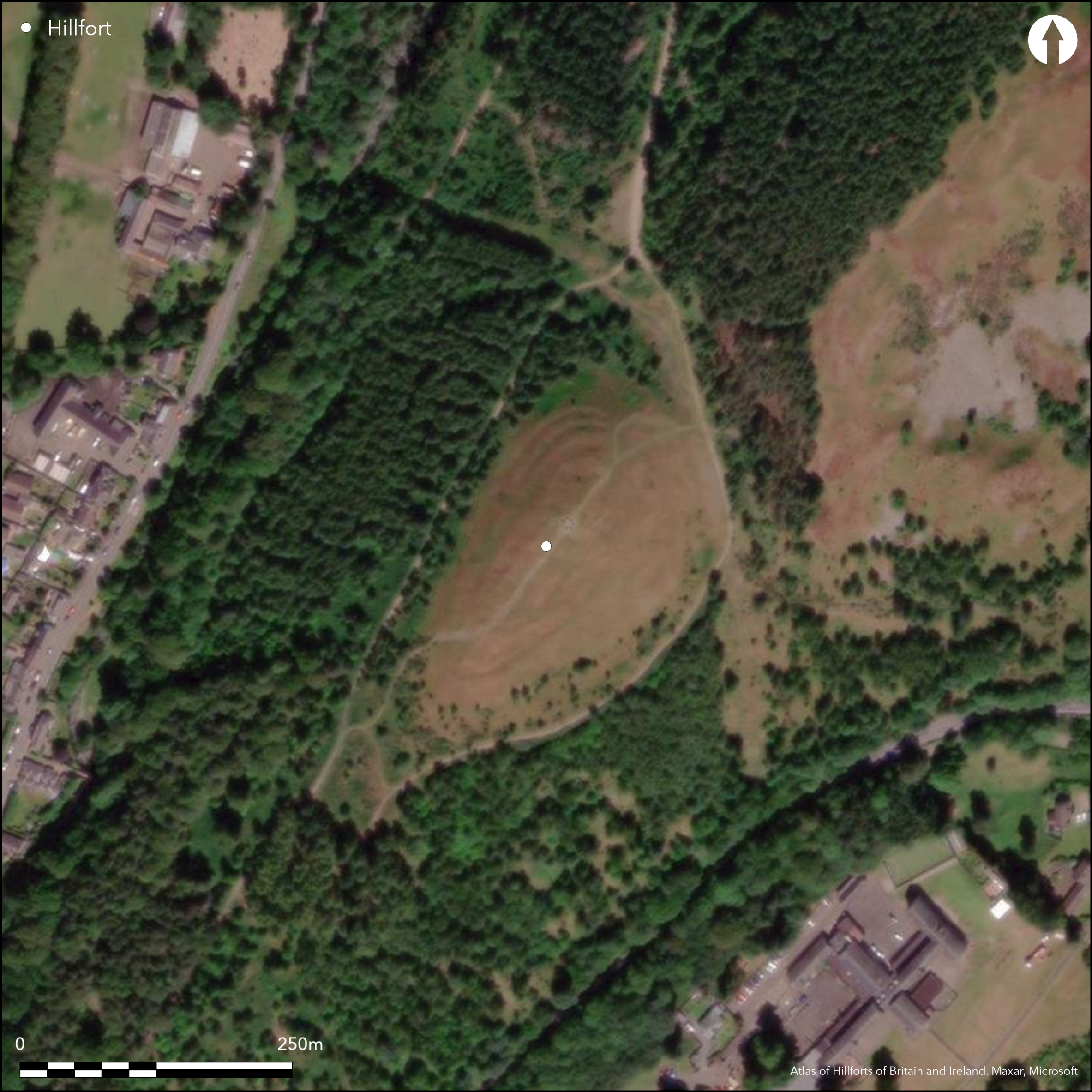
This fort is situated overlooking Innerleithen, on the lower SW spur of Pirn Craig. Here a saddle separates it from the main bulk of the hill on the NE, and the ground falls away dramatically from its summit along the NW and SE flanks. The defences of the fort comprise an inner and outer enclosure, the former defended by a single rampart and the outer by up to three, in each case now reduced to a stony scarp. RCAHMS investigators in 1960 were of the opinion that the inner was the earlier, but the relationship on the E, where the perimeter shares a common line with the inner rampart of the outer enclosure is ambiguous and the true sequence can only be established by excavation. Oval on plan, the inner enclosure measures about 105m from NE to SW by 45m transversely (0.36ha) and has entrances on the NE and SW. The outer enclosure is significantly larger, measuring internally about 145m from NE to SW by 60m transversely (0.68ha). Three ramparts can be seen on the N side of the entrance from the saddle on the NE, but elsewhere there are only two, and, like the inner enclosure, these are also pierced by an entrance on the SW. The stances of at least twenty timber round houses can be seen within the interior, fifteen of them within the inner enclosure and five in the space between the it and the outer defences on the SW; the majority are platforms, but in five a small central platform is enclosed by a shallow groove or ditch which forms a ledge where the stance has been cut back into the slope. Two of the houses within the inner enclosure appear to overlie its rampart, probably contributing the view of the RCAHMS investigators that this was the earlier element of the defences. In addition to the defences, a bank reduced to a low scarp has been drawn round the eastern flank of the spur lower down the slope, but its relationship to the fort is not known.
Citizen Science: ✗
Reliability of Data: Confirmed
Reliability of Interpretation: Confirmed
X: -340247 Y: 7484005 (EPSG: 3857)
Longitude: -3.0564899810030433 Latitude: 55.624399258228266 (EPSG:4326)
Country: Scotland
Current County or Unitary Authority: Scottish Borders
Historic County: Peeblesshire
Current Parish/Community/Council/Townland: Innerleithen
None
| Extant | ✓ |
| Cropmark | ✗ |
| Likely Destroyed | ✗ |
Planted with trees in the early 19th century, it now lies in clearing ground with coniferous and deciduous woodland round about.
| Woodland | ✗ |
| Commercial Forestry Plantation | ✗ |
| Parkland | ✗ |
| Pasture (Grazing) | ✗ |
| Arable | ✗ |
| Scrub/Bracken | ✗ |
| Bare Outcrop | ✗ |
| Heather/Moorland | ✓ |
| Heath | ✗ |
| Built-up | ✗ |
| Coastal Grassland | ✗ |
| Other | ✗ |
None
| Contour Fort | ✓ |
| Partial Contour Fort | ✗ |
| Promontory Fort | ✗ |
| Hillslope Fort | ✗ |
| Level Terrain Fort | ✗ |
| Marsh Fort | ✗ |
| Multiple Enclosure Fort | ✗ |
| Hilltop | ✓ |
| Coastal Promontory | ✗ |
| Inland Promontory | ✗ |
| Valley Bottom | ✗ |
| Knoll/Hillock/Outcrop | ✗ |
| Ridge | ✗ |
| Cliff/Plateau-edge/Scarp | ✗ |
| Hillslope | ✗ |
| Lowland | ✗ |
| Spur | ✓ |
Dominant Topographic Feature: None
| North | ✗ |
| Northeast | ✗ |
| East | ✗ |
| Southeast | ✗ |
| South | ✗ |
| Southwest | ✗ |
| West | ✗ |
| Northwest | ✗ |
| Level | ✓ |
Altitude: 230.0m
N/A
In the absence of excavation, there are neither stratified artefacts nor radiocarbon dates to provide a chronology for the defences.
Reliability: D - None
| Pre 1200BC | ✗ |
| 1200BC - 800BC | ✗ |
| 800BC - 400BC | ✗ |
| 400BC - AD50 | ✗ |
| AD50 - AD400 | ✗ |
| AD400 - AD 800 | ✗ |
| Post AD800 | ✗ |
| Unknown | ✓ |
| Pre Hillfort: | None |
| Post Hillfort: | Planted with trees in the early 19th century |
Photographed by RCAHMS Aerial Survey Programme in 1983, 1984 and 2009
| 1st Identified Map Depiction (1856): | Annotated Fort on the 1st edition OS 25-inch map (Peebles 1859, sheet 14.14) |
| Other (1863): | Description by William Chambers (1864, 29, 37) |
| Earthwork Survey (1886): | Sketch-plan and description by David Christison (1887, 26-7, fig 10) |
| Other (1958): | Scheduled |
| Earthwork Survey (1960): | Plan and description (RCAHMS 1967, 137-8, no.311, fig 126; RCAHMS PBD 134/1-3) |
| Other (1961): | Visited by the OS |
| Other (1974): | Revised at 1:2500 by the OS |
At least twenty round-houses (twenty-four identified by the OS), the majority platforms, but including five where an encircling groove or ditch has created a ledge on the backscarp. at least two overlie the inner rampart, while one is drawn on the RCAHMS plan of 1960 as if it is earlier, and they almost certainly represent several periods of construction and may include an unenclosed phase of settlement.
None
| None | ✓ |
| Spring | ✗ |
| Stream | ✗ |
| Pool | ✗ |
| Flush | ✗ |
| Well | ✗ |
| Other | ✗ |
Ring-grooves encircling platforms
| No Known Features | ✗ |
| Round Stone Structures | ✗ |
| Rectangular Stone Structures | ✗ |
| Curvilinear Platforms | ✓ |
| Other Roundhouse Evidence | ✓ |
| Pits | ✗ |
| Quarry Hollows | ✗ |
| Other | ✗ |
None
| No Known Excavation | ✓ |
| Pits | ✗ |
| Postholes | ✗ |
| Roundhouses | ✗ |
| Rectangular Structures | ✗ |
| Roads/Tracks | ✗ |
| Quarry Hollows | ✗ |
| Other | ✗ |
| Nothing Found | ✗ |
None
| No Known Geophysics | ✓ |
| Pits | ✗ |
| Roundhouses | ✗ |
| Rectangular Structures | ✗ |
| Roads/Tracks | ✗ |
| Quarry Hollows | ✗ |
| Other | ✗ |
| Nothing Found | ✗ |
None
| No Known Finds | ✓ |
| Pottery | ✗ |
| Metal | ✗ |
| Metalworking | ✗ |
| Human Bones | ✗ |
| Animal Bones | ✗ |
| Lithics | ✗ |
| Environmental | ✗ |
| Other | ✗ |
None
| APs Not Checked | ✗ |
| None | ✗ |
| Roundhouses | ✓ |
| Rectangular Structures | ✗ |
| Pits | ✗ |
| Postholes | ✗ |
| Roads/Tracks | ✗ |
| Other | ✗ |
See main summary
| 2: | None |
| 2: | None |
Guard Chambers: ✗
Chevaux de Frise: ✗
| 1. Simple Gap (North east): | Piercing both the inner and outer enclosures |
| 2. Simple Gap (South west): | Piercing both the inner and outer enclosures |
An inner enclosure with a single rampart and an outer enclosure with up to three
| Area 1: | 0.36ha. |
| Area 2: | 0.68ha. |
| Total: | 0.68ha. |
Total Footprint Area: 1.3ha.
None
| ✓ | Clearly a stratigraphic relationship between the inner and outer enclosures, but the sequence of construction is unclear |
| ✓ | None |
| NE Quadrant: | 4 |
| SE Quadrant: | 3 |
| SW Quadrant: | 3 |
| NW Quadrant: | 2 |
| Total: | 4 |
| Partial Univallate | ✗ |
| Univallate | ✗ |
| Partial Bivallate | ✓ |
| Bivallate | ✗ |
| Partial Multivallate | ✓ |
| Multivallate | ✗ |
| Unknown | ✗ |
| Partial Univallate | ✗ |
| Univallate | ✓ |
| Partial Bivallate | ✗ |
| Bivallate | ✗ |
| Partial Multivallate | ✗ |
| Multivallate | ✗ |
None
| None | ✗ |
| Earthen Bank | ✗ |
| Stone Wall | ✗ |
| Rubble | ✓ |
| Wall-walk | ✗ |
| Evidence of Timber | ✗ |
| Vitrification | ✗ |
| Other Burning | ✗ |
| Palisade | ✗ |
| Counter Scarp Bank | ✗ |
| Berm | ✗ |
| Unfinished | ✗ |
| Other | ✗ |
None
| None | ✗ |
| Earthen Bank | ✗ |
| Stone Wall | ✗ |
| Murus Duplex | ✗ |
| Timber-framed | ✗ |
| Timber-laced | ✗ |
| Vitrification | ✗ |
| Other Burning | ✗ |
| Palisade | ✗ |
| Counter Scarp Bank | ✗ |
| Berm | ✗ |
| Unfinished | ✗ |
| No Known Excavation | ✓ |
| Other | ✗ |
| ✗ | None |
| ✗ | None |
Number of Ditches: None
| ✗ | None |
Chambers, W (1864) A History of Peeblesshire. William and Robert Chambers: Edinburgh and London
Christison, D (1887) 'The prehistoric forts of Peeblesshire'. Proc Soc Antiq Scot 21 (1886-7), 13-82
RCAHMS (1967) The Royal Commission on the Ancient and Historical Monuments of Scotland. Peeblesshire: an inventory of the ancient monuments, 2v. HMSO: Edinburgh
Atlas of Hillforts:
Wikidata:
This work is licensed under CC BY-SA 4.0

 and should be cited as:
Lock, Gary and Ralston, Ian. 2024. Atlas of Hillforts of Britain and Ireland. Available at: https://hillforts.arch.ox.ac.uk
Document Version 1.1