Satellite Imagery
Satellite Imagery
HER: East Lothian Council MEL766 (None)
NMR: NT 56 SE 1 (56165)
SM: 751
NGR: NT 5703 6354
X: 357032 Y: 663540 (OSGB36)
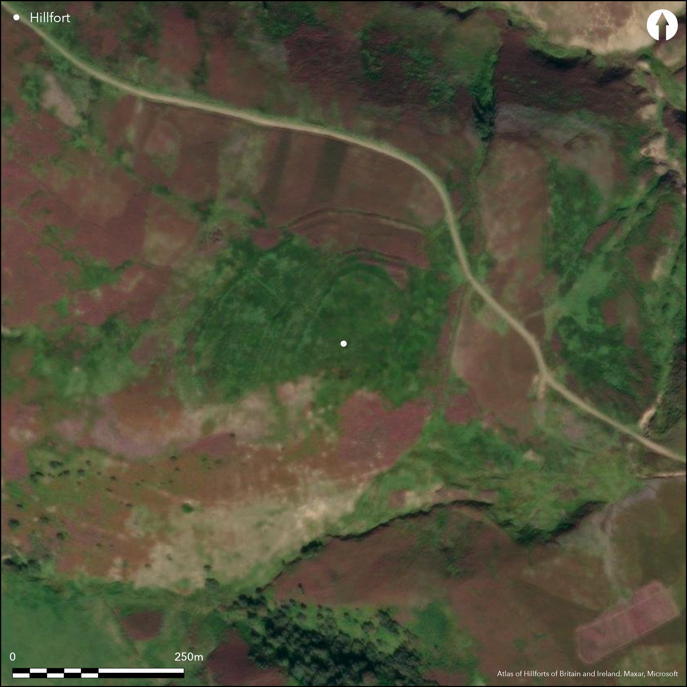
A complex fort occupies the summit of one of the NW spurs of Bleak Law above Hopes House, displaying multiple lines of ramparts and palisades, though their precise sequence cannot be established without excavation. At their simplest, the ramparts can be broken down into an inner and outer enclosure, both of which supersede an earlier timber-built perimeter comprising no fewer than three concentric palisade trenches. These can be traced across the interior of the outer enclosure on the NW, roughly following the contours of the hill and must have enclosed an area measuring about 165m from NE to SW by 100m transversely (1.2ha). It has an entrance midway along the NW flank where the outer and medial trenches turn inwards to merge either side of the gap. On the SW, this line of defence simply springs from the edge of the escarpment, while on the N it disappears beneath the outermost rampart of the inner enclosure, but midway between these points it is cut by a deeply worn entrance-way that extends up the slope from a gap in the outer enclosure on the NW. Other traces of palisade trenches can be seen within the inner enclosure, including a close-set pair of trenches set on the crest of what is probably a relatively early rampart cutting across the NE side of the interior, and a roughly oval single palisade trench enclosing the very summit of the hill; the latter measures some 37m from NW to SE by 34m transversely and is so well-preserved that it probably relates to one of the latest periods of occupation of the fort. The rampart defences of the inner enclosure, however, which vary from three on the NE to four on the NW and none along the lip of the escarpment on the SE, are not strictly concentric and on these grounds probably represent three or four phases of construction, the rampart with the pair of palisades on its crest perhaps enclosing an area measuring 70m from NE to SW by 60m transversely (0.38ha), and the one that succeeds it an area measuring an additional 30m in length (0.5ha). One entrance lies at the edge of the escarpment on the NE, while a second pierces all four ramparts on the NW. Curiously this entrance is not directly aligned with the hollowed trackway that mounts the slope through the entrance on this side of the outer enclosure, possibly indicating that the latter was conceived entirely separately from the inner enclosure rather than as an annexe to it. As an annexe, it would add about 1ha to the inner enclosure, while as a free-standing enclosure would have taken in about 2ha, though it does not make a particularly coherent scheme of enclosure in its present form; apparently comprising two lines of ramparts on the NW, the outer of which is very rough and irregular, on the N the inner peters out eastwards on the slope, and these features led Richard Feachem to consider it unfinished (1964, 124). Another relatively unusual feature of the fort is a linear earthwork with double banks and a medial ditch, which cuts across the saddle linking the spur to the higher ground on the E; a branch of the earthwork seems to mount the slope towards the NE entrance to the fort, though again its relationship to any of the defences is unknown.
Citizen Science: ✗
Reliability of Data: Confirmed
Reliability of Interpretation: Confirmed
X: -299236 Y: 7531222 (EPSG: 3857)
Longitude: -2.688083940805092 Latitude: 55.863157039090744 (EPSG:4326)
Country: Scotland
Current County or Unitary Authority: East Lothian
Historic County: East Lothian
Current Parish/Community/Council/Townland: Garvald And Bara
None
| Extant | ✓ |
| Cropmark | ✗ |
| Likely Destroyed | ✗ |
None
| Woodland | ✗ |
| Commercial Forestry Plantation | ✗ |
| Parkland | ✗ |
| Pasture (Grazing) | ✓ |
| Arable | ✗ |
| Scrub/Bracken | ✗ |
| Bare Outcrop | ✗ |
| Heather/Moorland | ✓ |
| Heath | ✗ |
| Built-up | ✗ |
| Coastal Grassland | ✗ |
| Other | ✗ |
None
| Contour Fort | ✓ |
| Partial Contour Fort | ✗ |
| Promontory Fort | ✗ |
| Hillslope Fort | ✗ |
| Level Terrain Fort | ✗ |
| Marsh Fort | ✗ |
| Multiple Enclosure Fort | ✓ |
| Hilltop | ✓ |
| Coastal Promontory | ✗ |
| Inland Promontory | ✗ |
| Valley Bottom | ✗ |
| Knoll/Hillock/Outcrop | ✗ |
| Ridge | ✗ |
| Cliff/Plateau-edge/Scarp | ✗ |
| Hillslope | ✗ |
| Lowland | ✗ |
| Spur | ✗ |
Dominant Topographic Feature: None
| North | ✗ |
| Northeast | ✗ |
| East | ✗ |
| Southeast | ✗ |
| South | ✗ |
| Southwest | ✗ |
| West | ✗ |
| Northwest | ✗ |
| Level | ✓ |
Altitude: 409.0m
N/A
In the absence of excavation, there are neither stratified artefacts nor radiocarbon dates to provide a chronology for the defences.
Reliability: D - None
| Pre 1200BC | ✗ |
| 1200BC - 800BC | ✗ |
| 800BC - 400BC | ✗ |
| 400BC - AD50 | ✗ |
| AD50 - AD400 | ✗ |
| AD400 - AD 800 | ✗ |
| Post AD800 | ✗ |
| Unknown | ✓ |
| Pre Hillfort: | None |
| Post Hillfort: | None |
Photographed by CUCAP in 1953 and 1955, John Dewar in 1971 (held by RCAHMS) and by RCAHMS Aerial Survey Programme in 1983, 1988, 2007, 2008 and 2010
| 1st Identified Map Depiction (1773): | Concentric ring on a hill symbol on Andrew and Mostyn Armstrong's Map of the three Lothians (1773) and named Picts Hill |
| Other (1853): | Annotated Fort on the 1st edition OS 6-inch map (Haddingtonshire 1855, sheet 19) |
| Other (1892): | Depicted on the OS 25-inch map (Haddingtonshire 1894, sheets 15.16 & 16.13) |
| Earthwork Survey (1921): | Plan and description (RCAHMS 1924, 151-3, no.257, fig. 188; RCAHMS ELD 26/1-7); probably also visited in 1913 |
| Other (1936): | Scheduled |
| Other (1954): | Description during RCAHMS Survey of Marginal Lands (Feachem 1963, 124) |
| Other (1979): | Surveyed at 1:10,000 by the OS |
The interior is under deep heather and while one or two scooped platforms are visible, there are probably several others
None
| None | ✓ |
| Spring | ✗ |
| Stream | ✗ |
| Pool | ✗ |
| Flush | ✗ |
| Well | ✗ |
| Other | ✗ |
Several scooped platforms are visible under heather within the interior and there is a palisaded enclosure within the innermost enclosure
| No Known Features | ✗ |
| Round Stone Structures | ✗ |
| Rectangular Stone Structures | ✗ |
| Curvilinear Platforms | ✓ |
| Other Roundhouse Evidence | ✗ |
| Pits | ✗ |
| Quarry Hollows | ✗ |
| Other | ✓ |
None
| No Known Excavation | ✓ |
| Pits | ✗ |
| Postholes | ✗ |
| Roundhouses | ✗ |
| Rectangular Structures | ✗ |
| Roads/Tracks | ✗ |
| Quarry Hollows | ✗ |
| Other | ✗ |
| Nothing Found | ✗ |
None
| No Known Geophysics | ✓ |
| Pits | ✗ |
| Roundhouses | ✗ |
| Rectangular Structures | ✗ |
| Roads/Tracks | ✗ |
| Quarry Hollows | ✗ |
| Other | ✗ |
| Nothing Found | ✗ |
None
| No Known Finds | ✓ |
| Pottery | ✗ |
| Metal | ✗ |
| Metalworking | ✗ |
| Human Bones | ✗ |
| Animal Bones | ✗ |
| Lithics | ✗ |
| Environmental | ✗ |
| Other | ✗ |
The smallest palisaded enclosure is visible within the interior
| APs Not Checked | ✗ |
| None | ✗ |
| Roundhouses | ✗ |
| Rectangular Structures | ✗ |
| Pits | ✗ |
| Postholes | ✗ |
| Roads/Tracks | ✗ |
| Other | ✓ |
See main summary
| 5: | Through all lines |
| 2: | Evidently multiperiod, but with two entrances through the inner belt of defences (1-2). An entrance with inturns belongs to what is probably an independent outer enclosure; and an entrance through an earlier triple palisade |
Guard Chambers: ✗
Chevaux de Frise: ✗
| 1. Simple Gap (North east): | Penetrating the inner belt of defences |
| 1. Oblique (North east): | Oblique approach to the innermost rampart exposing the visitor's right side |
| 1. Simple Gap (North east): | Through the outer earthworks at the edge of the escarpment |
| 1. Hollow Way (North east): | Mounts the slope between banks |
| 2. Simple Gap (North west): | Penetrating the inner belt of defences |
| 3. In-turned (North west): | Deeply worn hollow flanked by low banks extending back within the outermost earthworks |
| 3. Hollow Way (North west): | None |
| 4. Simple Gap (North west): | Earlier entrance through the triple palisades between the two sets of earthwork defences |
Multiple lines of ramparts and palisades creating a succession of enclosures backing onto the escarpment on the SE
| Area 1: | 0.38ha. |
| Area 2: | 0.5ha. |
| Area 3: | 1.2ha. |
| Area 4: | 2ha. |
| Total: | 2.0ha. |
Total Footprint Area: 2.5ha.
None
| ✓ | Evident sequence between palisade trenches and the earthwork defences |
| ✗ | None |
| NE Quadrant: | 5 |
| SE Quadrant: | 0 |
| SW Quadrant: | 6 |
| NW Quadrant: | 5 |
| Total: | 6 |
| Partial Univallate | ✗ |
| Univallate | ✗ |
| Partial Bivallate | ✗ |
| Bivallate | ✗ |
| Partial Multivallate | ✓ |
| Multivallate | ✗ |
| Unknown | ✗ |
| Partial Univallate | ✗ |
| Univallate | ✗ |
| Partial Bivallate | ✓ |
| Bivallate | ✗ |
| Partial Multivallate | ✗ |
| Multivallate | ✓ |
At least three phases of palisades. The outer ramparts were considered unfinished by Richard Feachem.
| None | ✗ |
| Earthen Bank | ✓ |
| Stone Wall | ✗ |
| Rubble | ✗ |
| Wall-walk | ✗ |
| Evidence of Timber | ✗ |
| Vitrification | ✗ |
| Other Burning | ✗ |
| Palisade | ✓ |
| Counter Scarp Bank | ✗ |
| Berm | ✗ |
| Unfinished | ✓ |
| Other | ✗ |
None
| None | ✗ |
| Earthen Bank | ✗ |
| Stone Wall | ✗ |
| Murus Duplex | ✗ |
| Timber-framed | ✗ |
| Timber-laced | ✗ |
| Vitrification | ✗ |
| Other Burning | ✗ |
| Palisade | ✗ |
| Counter Scarp Bank | ✗ |
| Berm | ✗ |
| Unfinished | ✗ |
| No Known Excavation | ✓ |
| Other | ✗ |
| ✗ | None |
| ✓ | The outermost rampart of the inner enclosure is certainly flanked by ditches, while the ramparts of the outer enclosure also have ditches. The presence of ditches and internal quarries accompanying the other ramparts has not been noted |
Number of Ditches: 3
| ✓ | The outer enclosure may be described as an annexe of about 1ha within two irregualr lines of ramparts, but the inturned entrance is not aligned on the inner entrance and it is perhaps more likely that this has been a free-standing enclosure |
Feachem, R W (1963) A guide to prehistoric Scotland. Batsford: London
RCAHMS (1924) The Royal Commission on the Ancient and Historical Monuments and Constructions of Scotland. Eighth report with Inventory of Monuments and Constructions in the County of East Lothian. HMSO: Edinburgh
Atlas of Hillforts:
Wikidata:
This work is licensed under CC BY-SA 4.0

 and should be cited as:
Lock, Gary and Ralston, Ian. 2024. Atlas of Hillforts of Britain and Ireland. Available at: https://hillforts.arch.ox.ac.uk
Document Version 1.1