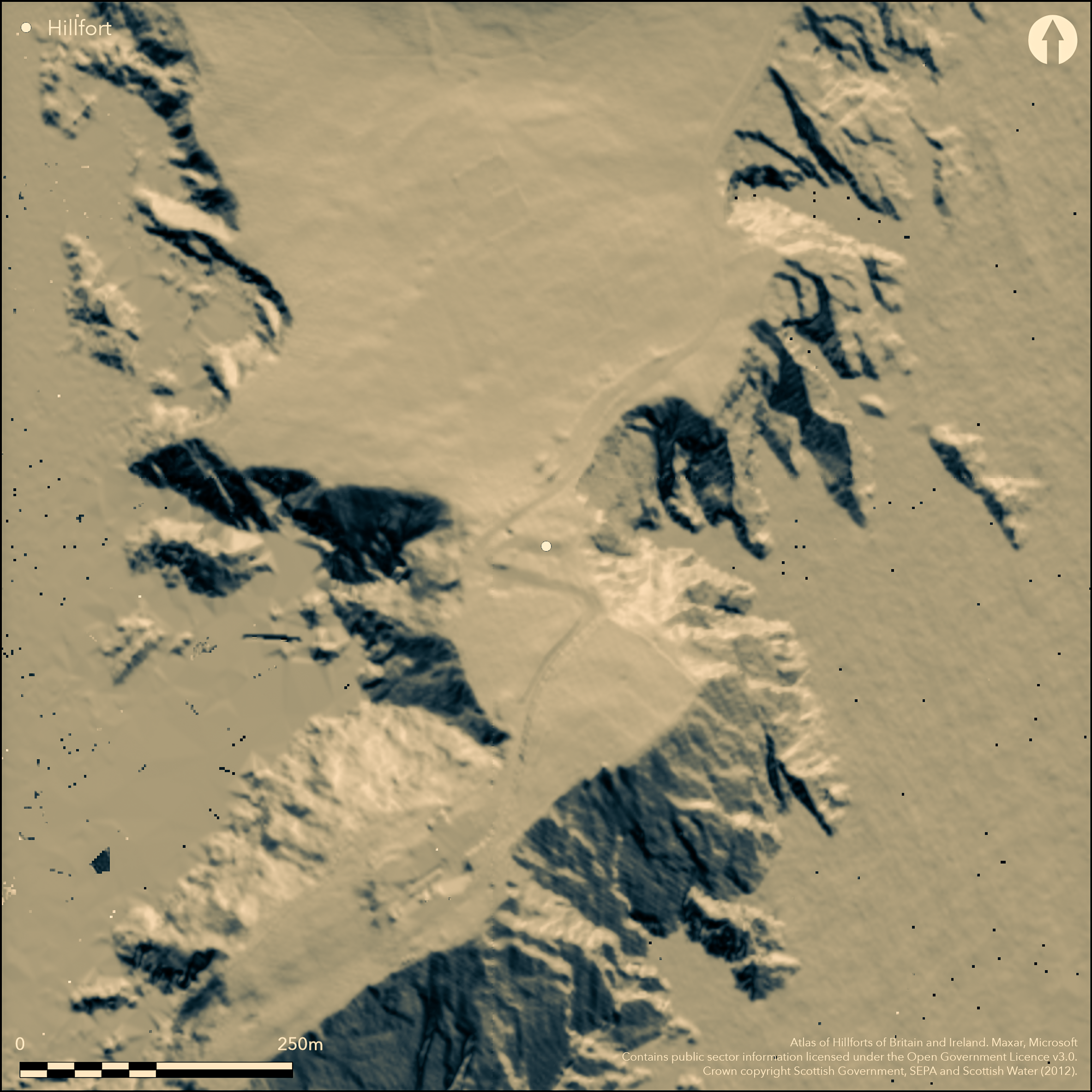
LiDAR 1m DTM Hillshade
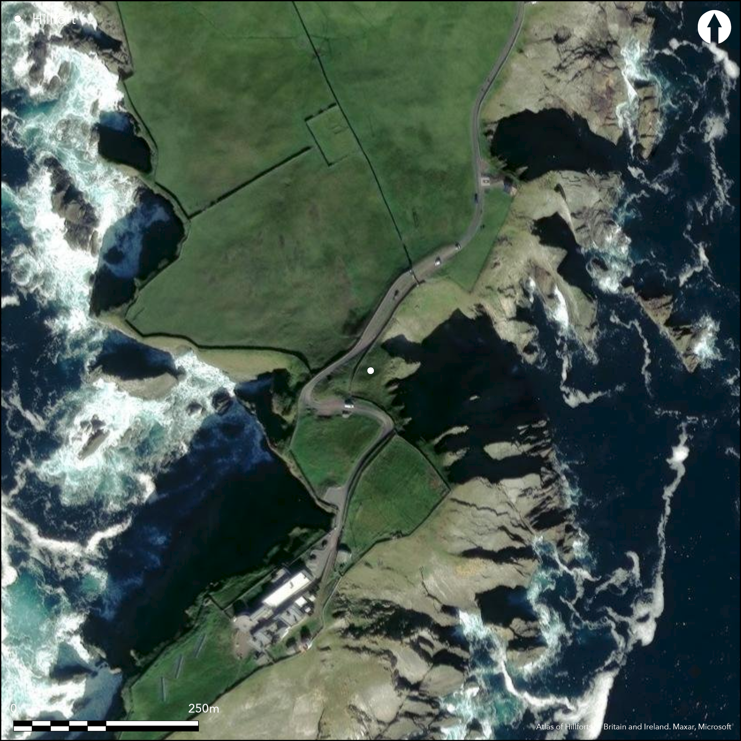
Satellite Imagery
LiDAR 1m DTM Hillshade
Satellite Imagery
Scroll left/right to view further images.
HER: Shetland Amenity Trust 551 & 3738 (None)
NMR: HU 40 NW 1 (896)
SM: None
NGR: HU 4077 0803
X: 440770 Y: 1108030 (OSGB36)
There is a long-standing tradition that Sumburgh Head is the site of a fortification of some description, though the assertion by Sir Henry Dryden that it was a broch (1874, 211) is otherwise unsupported by any evidence. Nevertheless, George Low, visiting in 1774, claimed that access across the neck of the promontory was barred by 'a ditch and strong wall' (1879, 185), and in 1968 the OS identified two possible ramparts and ditches spanning the 50m wide neck where the road to the lighthouse zigzags up towards the summit; the ramparts, which are plainly visible on satellite imagery taken in 2004, have been reduced to scarps between 0.5m and 0.8m in height. This implies a large fort some 300m in length enclosing about 1.9ha along its crest, though the area of broken outcrops and bare rock descending to the sea covers a considerably larger area. Inevitably these possible defences are set at the point where any later agricultural boundary enclosing the headland is likely to have been placed and the true character of these remains can only be established by excavation. No trace of any entrance is visible at the neck, and nothing of the 'foundation of a large house' that Low observed at what he considered to be the entrance, nor of the numerous small buildings that lay 'along the wall and at some distance' (1789, 185), features that Raymond Lamb has suggested might have been comparable to the structures found in several promontory enclosures that are likely to have served as early medieval monastic sites (1973, 78).
Citizen Science: ✗
Reliability of Data: Unconfirmed
Reliability of Interpretation: Confirmed
X: -141818 Y: 8367653 (EPSG: 3857)
Longitude: -1.2739748788769079 Latitude: 59.85557199320831 (EPSG:4326)
Country: Scotland
Current County or Unitary Authority: Shetland Islands
Historic County: Shetland
Current Parish/Community/Council/Townland: Dunrossness
None
| Extant | ✓ |
| Cropmark | ✗ |
| Likely Destroyed | ✓ |
None
| Woodland | ✗ |
| Commercial Forestry Plantation | ✗ |
| Parkland | ✗ |
| Pasture (Grazing) | ✓ |
| Arable | ✗ |
| Scrub/Bracken | ✗ |
| Bare Outcrop | ✗ |
| Heather/Moorland | ✓ |
| Heath | ✗ |
| Built-up | ✗ |
| Coastal Grassland | ✗ |
| Other | ✗ |
None
| Contour Fort | ✗ |
| Partial Contour Fort | ✗ |
| Promontory Fort | ✓ |
| Hillslope Fort | ✗ |
| Level Terrain Fort | ✗ |
| Marsh Fort | ✗ |
| Multiple Enclosure Fort | ✗ |
| Hilltop | ✗ |
| Coastal Promontory | ✓ |
| Inland Promontory | ✗ |
| Valley Bottom | ✗ |
| Knoll/Hillock/Outcrop | ✗ |
| Ridge | ✗ |
| Cliff/Plateau-edge/Scarp | ✗ |
| Hillslope | ✗ |
| Lowland | ✗ |
| Spur | ✗ |
Dominant Topographic Feature: None
| North | ✗ |
| Northeast | ✗ |
| East | ✗ |
| Southeast | ✗ |
| South | ✗ |
| Southwest | ✗ |
| West | ✗ |
| Northwest | ✗ |
| Level | ✓ |
Altitude: 80.0m
N/A
In the absence of excavation, there are neither stratified artefacts nor radiocarbon dates to provide a chronology for the defences.
Reliability: D - None
| Pre 1200BC | ✗ |
| 1200BC - 800BC | ✗ |
| 800BC - 400BC | ✗ |
| 400BC - AD50 | ✗ |
| AD50 - AD400 | ✗ |
| AD400 - AD 800 | ✗ |
| Post AD800 | ✗ |
| Unknown | ✓ |
| Pre Hillfort: | None |
| Post Hillfort: | Now occupied by the lighthouse and its services |
Sumburgh Head has been photographed by RCAHMS Aerial Survey Programme, though there is little evidence of any fortifications on the photographs
| 1st Identified Map Depiction (1654): | Annotated 'The ancient fort of Swenbrugh' on Orcadum et Shetlandiae Insularum accuratissima descriptio, in Blaeu's Atlas |
| 1st Identified Written Reference (1774): | Description by G Low (1879, 185) |
| Other (1930): | Description (RCAHMS 1946, iii, 45, no.1189) |
| Other (1968): | Possible ramparts surveyed at 1:2500 by the OS |
| Other (1970): | A visit by Raymond Lamb is confirmed by a single photograph held by RCAHMS, though he does not offer his own observation of the defences recorded by the OS (Lamb 1980, 81-2) |
Occupied by the lighthouse and its facilities and services. According to Low a series of small buildings were visible adjacent to the defences
None
| None | ✓ |
| Spring | ✗ |
| Stream | ✗ |
| Pool | ✗ |
| Flush | ✗ |
| Well | ✗ |
| Other | ✗ |
None
| No Known Features | ✓ |
| Round Stone Structures | ✗ |
| Rectangular Stone Structures | ✗ |
| Curvilinear Platforms | ✗ |
| Other Roundhouse Evidence | ✗ |
| Pits | ✗ |
| Quarry Hollows | ✗ |
| Other | ✗ |
None
| No Known Excavation | ✓ |
| Pits | ✗ |
| Postholes | ✗ |
| Roundhouses | ✗ |
| Rectangular Structures | ✗ |
| Roads/Tracks | ✗ |
| Quarry Hollows | ✗ |
| Other | ✗ |
| Nothing Found | ✗ |
None
| No Known Geophysics | ✓ |
| Pits | ✗ |
| Roundhouses | ✗ |
| Rectangular Structures | ✗ |
| Roads/Tracks | ✗ |
| Quarry Hollows | ✗ |
| Other | ✗ |
| Nothing Found | ✗ |
None
| No Known Finds | ✓ |
| Pottery | ✗ |
| Metal | ✗ |
| Metalworking | ✗ |
| Human Bones | ✗ |
| Animal Bones | ✗ |
| Lithics | ✗ |
| Environmental | ✗ |
| Other | ✗ |
NO APPARENT FEATURES
| APs Not Checked | ✗ |
| None | ✓ |
| Roundhouses | ✗ |
| Rectangular Structures | ✗ |
| Pits | ✗ |
| Postholes | ✗ |
| Roads/Tracks | ✗ |
| Other | ✗ |
Must approach across the neck from the N
| 0: | None |
| 2: | Must approach across the neck from the N |
Guard Chambers: ✗
Chevaux de Frise: ✗
Possibly two ramparts and ditches cutting off the headland
| Area 1: | 1.9ha. |
| Total: | 1.9ha. |
Total Footprint Area: Noneha.
None
| ✗ | None |
| ✗ | Requires confirmation by fieldwork |
| NE Quadrant: | 2 |
| SE Quadrant: | 0 |
| SW Quadrant: | 0 |
| NW Quadrant: | 0 |
| Total: | 2 |
| Partial Univallate | ✗ |
| Univallate | ✗ |
| Partial Bivallate | ✓ |
| Bivallate | ✗ |
| Partial Multivallate | ✗ |
| Multivallate | ✗ |
| Unknown | ✗ |
| Partial Univallate | ✗ |
| Univallate | ✗ |
| Partial Bivallate | ✗ |
| Bivallate | ✗ |
| Partial Multivallate | ✗ |
| Multivallate | ✗ |
Possible traces of ramparts
| None | ✗ |
| Earthen Bank | ✓ |
| Stone Wall | ✗ |
| Rubble | ✗ |
| Wall-walk | ✗ |
| Evidence of Timber | ✗ |
| Vitrification | ✗ |
| Other Burning | ✗ |
| Palisade | ✗ |
| Counter Scarp Bank | ✗ |
| Berm | ✗ |
| Unfinished | ✗ |
| Other | ✗ |
None
| None | ✗ |
| Earthen Bank | ✗ |
| Stone Wall | ✗ |
| Murus Duplex | ✗ |
| Timber-framed | ✗ |
| Timber-laced | ✗ |
| Vitrification | ✗ |
| Other Burning | ✗ |
| Palisade | ✗ |
| Counter Scarp Bank | ✗ |
| Berm | ✗ |
| Unfinished | ✗ |
| No Known Excavation | ✓ |
| Other | ✗ |
| ✗ | None |
| ✓ | Possibly two ditches, but requires confirmation by fieldwork |
Number of Ditches: 2
| ✗ | None |
Dryden, H (1873) 'Notice of the brochs or "Pictish towers" of Mousa, Clickhimin, &c, in Shetland, illustrative of part of the series of plans and sections deposited in the library of the Society'. Archaeol Scot 5.1 (1874), 199-212
Lamb, R G (1973) 'Coastal settlements of the north'. Scot Archaeol Forum 5 (1973), 76-98
Lamb, R G (1980) Iron Age promontory forts in the Northern Isles. Brit Archaeol Rep, British Ser 79. BAR: Oxford
Low, G (1879) A Tour through the Islands of Orkney and Schetland in 1774. Kirkwall
RCAHMS (1946) The Royal Commission on the Ancient and Historical Monuments of Scotland. Twelfth report with an inventory of the ancient monuments of Orkney and Shetland, 3v. HMSO: Edinburgh
Atlas of Hillforts:
Wikidata:
This work is licensed under CC BY-SA 4.0

 and should be cited as:
Lock, Gary and Ralston, Ian. 2024. Atlas of Hillforts of Britain and Ireland. Available at: https://hillforts.arch.ox.ac.uk
Document Version 1.1