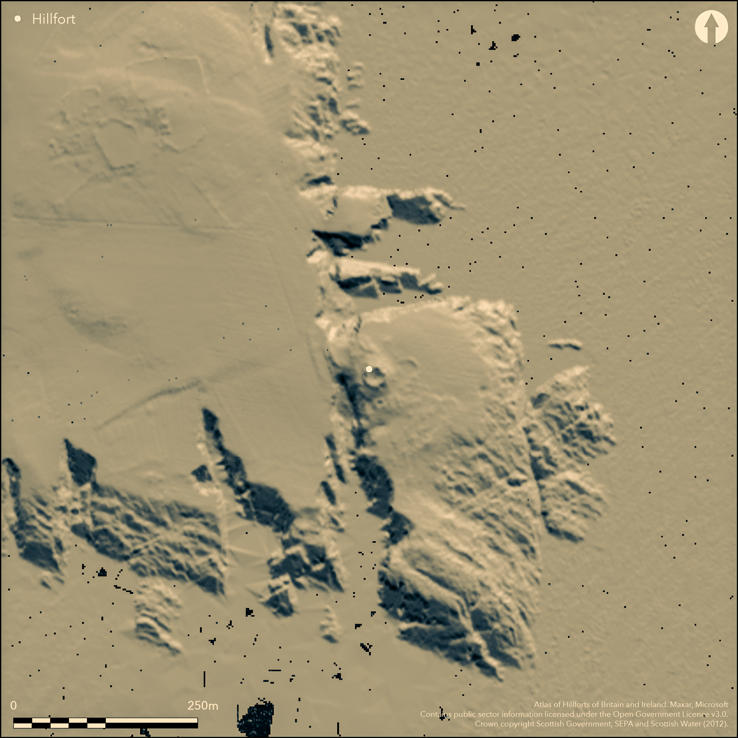
LiDAR 1m DTM Hillshade
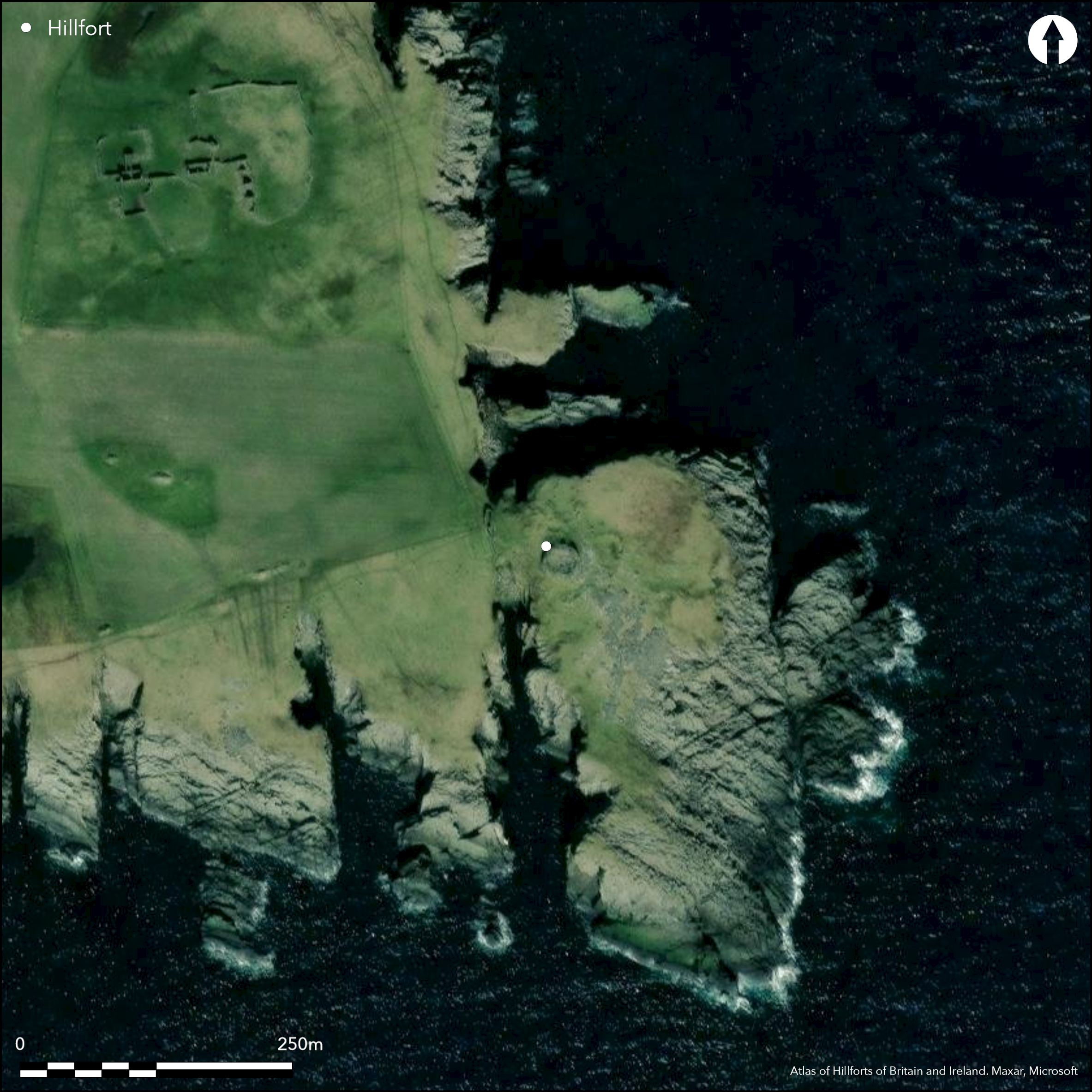
Satellite Imagery
LiDAR 1m DTM Hillshade
Satellite Imagery
Scroll left/right to view further images.
HER: Shetland Amenity Trust 726 (None)
NMR: HU 42 SW 1 (948)
SM: 2054
NGR: HU 4468 2319
X: 444680 Y: 1123190 (OSGB36)
The W headland at the mouth of the S end of the Sound of Mousa is best known for its broch, standing opposite the rather better preserved tower on the island of Mousa, but the headland itself is defended by two walls cutting across the neck that connects it at the NW corner to the mainland. The outer of these, now no more than 0.5m high, is surmounted by a modern arrangement of drystone walls designed to control the access of stock onto the promontory and also forming a narrow pen, and is positioned where the precipitous geos to N and S are no more than 28m apart. Behind it a second wall reduced largely to a grass-grown bank cuts across the neck, and the coastal erosion survey carried out in 1998, suggests there may be yet another parallel bank behind this (see SCAPE Burraland: 6571). The area cut off on the headland is extensive, measuring 250m from in overall length from NNW to SSE by up to 110m in breadth (2ha), but over half of this is now bare storm-washed rock dipping down southwards to the sea. Nevertheless, an area of at least 0.9ha has formerly been grass-grown, though the storm beach is actively advancing into this area from the SSE and the occupiable area may well have been in excess of 1ha. The broch, with its galleried walls still over 2.5m in height and an entrance on the W, stands on the W side of this area, adjacent to the top of the southern geo separating the headland from the mainland. Around it, however, are extensive remains of a surrounding settlement, with evidence of numerous circular, oval and sub-rectangular stone structures detectable in the general spread of rubble beneath the turf. While these structures probably relate to contemporary or subsequent occupation around the broch, there is no particular reason to assume that either the broch or its surrounding settlement are associated with the defences across the neck.
Citizen Science: ✗
Reliability of Data: Confirmed
Reliability of Interpretation: Confirmed
X: -133686 Y: 8397797 (EPSG: 3857)
Longitude: -1.2009205256630464 Latitude: 59.991281623099894 (EPSG:4326)
Country: Scotland
Current County or Unitary Authority: Shetland Islands
Historic County: Shetland
Current Parish/Community/Council/Townland: Dunrossness
Active erosion of the cliff-edge on the W and at the top of the outcrops on the S
| Extant | ✓ |
| Cropmark | ✗ |
| Likely Destroyed | ✗ |
None
| Woodland | ✗ |
| Commercial Forestry Plantation | ✗ |
| Parkland | ✗ |
| Pasture (Grazing) | ✓ |
| Arable | ✗ |
| Scrub/Bracken | ✗ |
| Bare Outcrop | ✗ |
| Heather/Moorland | ✗ |
| Heath | ✗ |
| Built-up | ✗ |
| Coastal Grassland | ✓ |
| Other | ✗ |
None
| Contour Fort | ✗ |
| Partial Contour Fort | ✗ |
| Promontory Fort | ✓ |
| Hillslope Fort | ✗ |
| Level Terrain Fort | ✗ |
| Marsh Fort | ✗ |
| Multiple Enclosure Fort | ✗ |
| Hilltop | ✗ |
| Coastal Promontory | ✓ |
| Inland Promontory | ✗ |
| Valley Bottom | ✗ |
| Knoll/Hillock/Outcrop | ✗ |
| Ridge | ✗ |
| Cliff/Plateau-edge/Scarp | ✗ |
| Hillslope | ✗ |
| Lowland | ✗ |
| Spur | ✗ |
Dominant Topographic Feature: None
| North | ✗ |
| Northeast | ✗ |
| East | ✗ |
| Southeast | ✗ |
| South | ✗ |
| Southwest | ✗ |
| West | ✗ |
| Northwest | ✗ |
| Level | ✓ |
Altitude: 20.0m
N/A
In the absence of excavation, there are neither stratified artefacts nor radiocarbon dates to provide a chronology for the defences.
Reliability: D - None
| Pre 1200BC | ✗ |
| 1200BC - 800BC | ✗ |
| 800BC - 400BC | ✗ |
| 400BC - AD50 | ✗ |
| AD50 - AD400 | ✗ |
| AD400 - AD 800 | ✗ |
| Post AD800 | ✗ |
| Unknown | ✓ |
| Pre Hillfort: | None |
| Post Hillfort: | Possibly the broch and the traces of structures around it occupy part of the interior of an earlier fort |
RCAHMS hold an extensive series of ground and aerial photographs
| 1st Identified Written Reference (1774): | Visit by George Low noted by Samuel Hibbert (1822, 255-6) |
| Other (1822): | Description by Samuel Hibbert (1822, 255-6) |
| Other (1852): | Plan of the broch by Sir Henry Dryden (RCAHMS SHD 2/3-6, DC 51980; & DP168130, DP168370-2) |
| 1st Identified Map Depiction (1878): | Annotated Brough of Burraland on 1st edition OS 6-inch map (Shetland 1882, sheet 62) |
| Other (1930): | Plan and description of the broch (RCAHMS 1946, iii, 24, no.1143; RCAHMS SHD 2/1) |
| Other (1934): | Scheduled |
| Other (1968): | Surveyed at 1/2500 by the OS |
| Other (1970): | Description by Raymond Lamb of the promontory defences (1980, 82; photographs held by RCAHMS) |
| Other (1987): | Description of the broch by Euan MacKie (2002, 81-2; photographs held by RCAHMS) |
| Other (1998): | Description (Shetland Coastal Survey: South Mainland, Lunnasting, Whalsay, 1998; Wilson 2003, 43) |
| Other (2012): | Re-Scheduled |
| Other (2014): | Visit (SCAPE: Burraland (6571) |
Partly occupied by a broch with extensive traces of surrounding structures ranging in shape from circular to sub-rectangular
None
| None | ✓ |
| Spring | ✗ |
| Stream | ✗ |
| Pool | ✗ |
| Flush | ✗ |
| Well | ✗ |
| Other | ✗ |
In addition to the broch, the structures around it range from circular to sub-rectangular
| No Known Features | ✗ |
| Round Stone Structures | ✓ |
| Rectangular Stone Structures | ✓ |
| Curvilinear Platforms | ✗ |
| Other Roundhouse Evidence | ✗ |
| Pits | ✗ |
| Quarry Hollows | ✗ |
| Other | ✓ |
None
| No Known Excavation | ✓ |
| Pits | ✗ |
| Postholes | ✗ |
| Roundhouses | ✗ |
| Rectangular Structures | ✗ |
| Roads/Tracks | ✗ |
| Quarry Hollows | ✗ |
| Other | ✗ |
| Nothing Found | ✗ |
None
| No Known Geophysics | ✓ |
| Pits | ✗ |
| Roundhouses | ✗ |
| Rectangular Structures | ✗ |
| Roads/Tracks | ✗ |
| Quarry Hollows | ✗ |
| Other | ✗ |
| Nothing Found | ✗ |
None
| No Known Finds | ✓ |
| Pottery | ✗ |
| Metal | ✗ |
| Metalworking | ✗ |
| Human Bones | ✗ |
| Animal Bones | ✗ |
| Lithics | ✗ |
| Environmental | ✗ |
| Other | ✗ |
Broch and at least one circular structure visible amid the rubble
| APs Not Checked | ✗ |
| None | ✗ |
| Roundhouses | ✓ |
| Rectangular Structures | ✗ |
| Pits | ✗ |
| Postholes | ✗ |
| Roads/Tracks | ✗ |
| Other | ✓ |
Presumably across the neck on the W side
| 0: | None |
| 2: | Presumably across the neck on the W side |
Guard Chambers: ✗
Chevaux de Frise: ✗
Two walls apparently cut off access at the neck to a minimum 0f 0.9ha on a much larger promontory where what is now bare rock extends down to the on the S and E over an area of another 1.1ha
| Area 1: | 0.9ha. |
| Total: | 0.9ha. |
Total Footprint Area: 2.0ha.
None
| ✗ | None |
| ✗ | None |
| NE Quadrant: | 0 |
| SE Quadrant: | 0 |
| SW Quadrant: | 0 |
| NW Quadrant: | 2 |
| Total: | 2 |
| Partial Univallate | ✗ |
| Univallate | ✗ |
| Partial Bivallate | ✓ |
| Bivallate | ✗ |
| Partial Multivallate | ✗ |
| Multivallate | ✗ |
| Unknown | ✗ |
| Partial Univallate | ✗ |
| Univallate | ✗ |
| Partial Bivallate | ✗ |
| Bivallate | ✗ |
| Partial Multivallate | ✗ |
| Multivallate | ✗ |
None
| None | ✗ |
| Earthen Bank | ✗ |
| Stone Wall | ✓ |
| Rubble | ✗ |
| Wall-walk | ✗ |
| Evidence of Timber | ✗ |
| Vitrification | ✗ |
| Other Burning | ✗ |
| Palisade | ✗ |
| Counter Scarp Bank | ✗ |
| Berm | ✗ |
| Unfinished | ✗ |
| Other | ✗ |
None
| None | ✗ |
| Earthen Bank | ✗ |
| Stone Wall | ✗ |
| Murus Duplex | ✗ |
| Timber-framed | ✗ |
| Timber-laced | ✗ |
| Vitrification | ✗ |
| Other Burning | ✗ |
| Palisade | ✗ |
| Counter Scarp Bank | ✗ |
| Berm | ✗ |
| Unfinished | ✗ |
| No Known Excavation | ✓ |
| Other | ✗ |
| ✗ | None |
| ✗ | Natural cleft |
Number of Ditches: None
| ✗ | None |
Hibbert, S (1822) A Description of the Shetland Islands. Constable and Co: Edinburgh
Lamb, R G (1980) Iron Age promontory forts in the Northern Isles. Brit Archaeol Rep, British Ser 79. BAR: Oxford
MacKie, E W (2002) The roundhouses, brochs and wheelhouses of Atlantic Scotland c. 700BC - AD500: architecture and material culture Part 1 - The Orkney and Shetland Isles. BAR British Series 342: Oxford
RCAHMS (1946) The Royal Commission on the Ancient and Historical Monuments of Scotland. Twelfth report with an inventory of the ancient monuments of Orkney and Shetland, 3v. HMSO: Edinburgh
SCAPE https://scharp.co.uk/
Wilson, G (2003) 'Assessment survey: Shetland'. In Dawson, T (ed) Coastal archaeology and erosion in Scotland. Edinburgh
Atlas of Hillforts:
Wikidata:
This work is licensed under CC BY-SA 4.0

 and should be cited as:
Lock, Gary and Ralston, Ian. 2024. Atlas of Hillforts of Britain and Ireland. Available at: https://hillforts.arch.ox.ac.uk
Document Version 1.1