Satellite Imagery
Satellite Imagery
HER: Shetland Amenity Trust 2110 (None)
NMR: HU 69 SE 2 (1422)
SM: 3869
NGR: HU 6703 9300
X: 467030 Y: 1193005 (OSGB36)
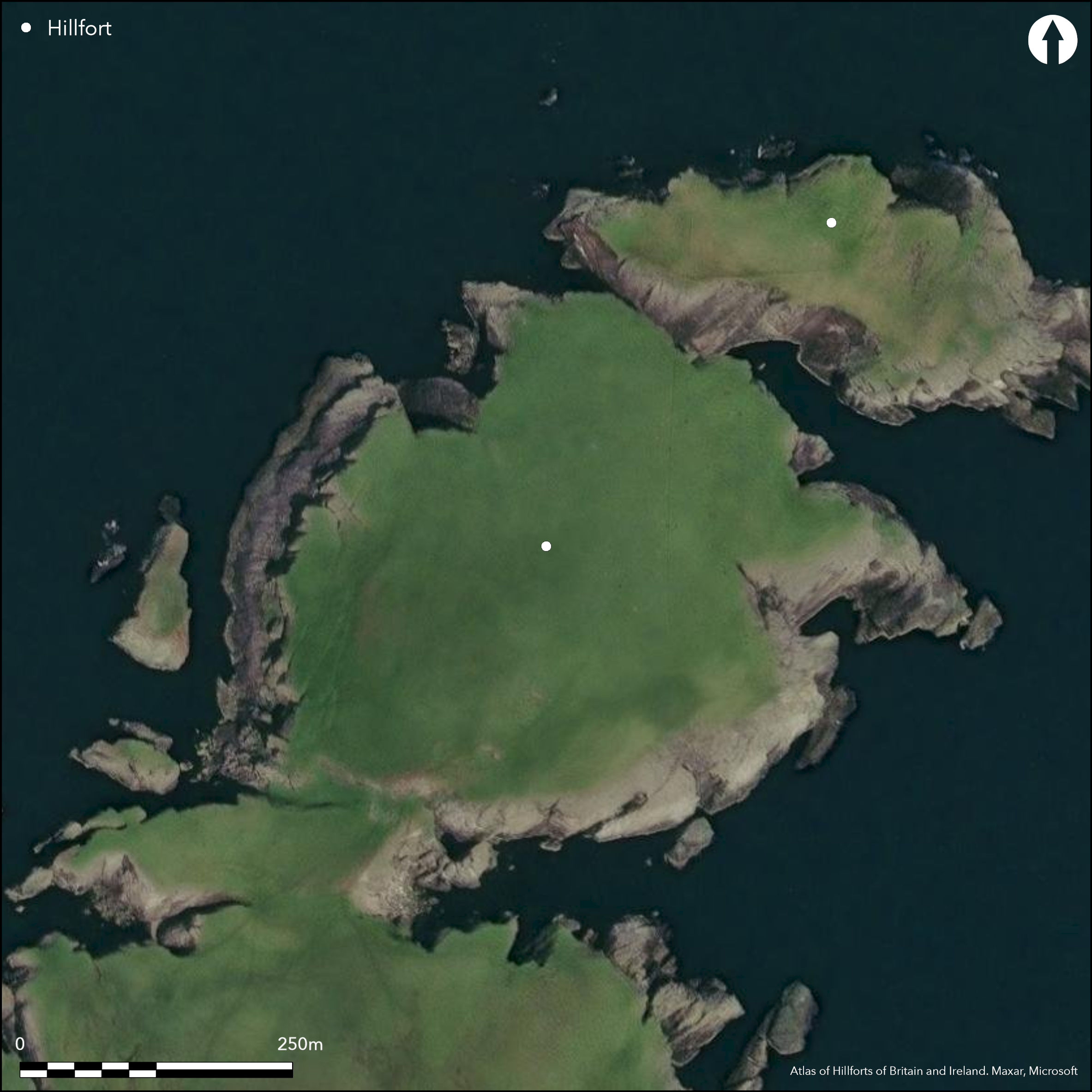
Strandburgh Ness, which forms the NE tip of the island of Fetlar is divided between a precipitous island known as the Outer Brough (Atlas No. ) and a larger promontory known as the Inner Brough. When they became separated is unknown, though the appearance of the name 'Stak of Standebrugh' on the Blaeus' rendering of the Shetlands suggests that it had taken place before 1654. Nevertheless, not only has the Outer traces of a wall extending along its landward side (see Atlas No.4195), but access to the Inner has also been barred at a relatively narrow neck some 45m wide between the Wester and Easter Burgi Geos. Described by Raymond Lamb as a Çmassive earth rampart' some 9m in thickness by 2.4m in height (Lamb 1970), and apparently accompanied by an internal quarry ditch (Lamb 1973, 87, fig 3), this feature was not recognised by either the RCAHMS investigators who visited the headland in 1930 (RCAHMS 1946, iii, 62-3, no.1240), or an OS surveyor in the year before Lamb's visit, though its line is implicit in the boundary of the Schedule drawn up in 1976. A more recent visit by Val Turner noted the presence of three ramparts drawn across the neck, with traces of intermediate ditches, and the outer ones standing 2.5m to 3m high. Some 40m NE of the ramparts at the neck, a more modern dyke with an attached sheepfold cuts across the neck, and above this the ground rises into a low crag, the line of which Lamb suggested had been adapted as an inner defence (1970). Girt with cliffs, the area enclosed behind this crag measures about 300m in length from NE to SW by 210m in breadth, extending to about 3.8ha, while an additional 0.57ha lies between the crag and the bank across the neck. At the head of the cliffs on the W side of the promontory a cluster of at least ten sub-rectangular buildings is visible, including several with multiple conjoined compartments (Lamb 1973, 87, fig 3), and he also noted less well-defined platforms on the summit of the headland. As initially recorded, Lamb interpreted the Inner Brough as a promontory fort and/or a monastic site, but in later syntheses he placed it firmly in the latter category, attributing it to the Norse period (1973, 1976).
Citizen Science: ✗
Reliability of Data: Confirmed
Reliability of Interpretation: Unconfirmed
X: -86519 Y: 8537944 (EPSG: 3857)
Longitude: -0.7772168510963867 Latitude: 60.61496366197121 (EPSG:4326)
Country: Scotland
Current County or Unitary Authority: Shetland Islands
Historic County: Shetland
Current Parish/Community/Council/Townland: Fetlar
None
| Extant | ✓ |
| Cropmark | ✗ |
| Likely Destroyed | ✗ |
None
| Woodland | ✗ |
| Commercial Forestry Plantation | ✗ |
| Parkland | ✗ |
| Pasture (Grazing) | ✓ |
| Arable | ✗ |
| Scrub/Bracken | ✗ |
| Bare Outcrop | ✗ |
| Heather/Moorland | ✓ |
| Heath | ✗ |
| Built-up | ✗ |
| Coastal Grassland | ✗ |
| Other | ✗ |
None
| Contour Fort | ✗ |
| Partial Contour Fort | ✗ |
| Promontory Fort | ✓ |
| Hillslope Fort | ✗ |
| Level Terrain Fort | ✗ |
| Marsh Fort | ✗ |
| Multiple Enclosure Fort | ✗ |
| Hilltop | ✗ |
| Coastal Promontory | ✓ |
| Inland Promontory | ✗ |
| Valley Bottom | ✗ |
| Knoll/Hillock/Outcrop | ✗ |
| Ridge | ✗ |
| Cliff/Plateau-edge/Scarp | ✗ |
| Hillslope | ✗ |
| Lowland | ✗ |
| Spur | ✗ |
Dominant Topographic Feature: None
| North | ✗ |
| Northeast | ✗ |
| East | ✗ |
| Southeast | ✗ |
| South | ✗ |
| Southwest | ✗ |
| West | ✗ |
| Northwest | ✗ |
| Level | ✓ |
Altitude: 40.0m
N/A
In the absence of excavation, there are neither stratified artefacts nor radiocarbon dates to provide a chronology for the bank cutting across the neck
Reliability: D - None
| Pre 1200BC | ✗ |
| 1200BC - 800BC | ✗ |
| 800BC - 400BC | ✗ |
| 400BC - AD50 | ✗ |
| AD50 - AD400 | ✗ |
| AD400 - AD 800 | ✗ |
| Post AD800 | ✗ |
| Unknown | ✓ |
| Pre Hillfort: | None |
| Post Hillfort: | None |
| Morphology/Earthwork/Typology: | The form of the buildings has led to an interpretation that this is a monastic site of Norse date (Lamb 1973; 1976) |
Photographed by RCAHMS Aerial Survey Programme in 2014. A visit by Val Turner of the Shetland Amenity Trust is undated.
| 1st Identified Written Reference (1930): | Description (RCAHMS 1946, iii, 62-3, no.1240 |
| Other (1969): | Visited by the OS, who found only the small quarry-pits |
| Earthwork Survey (1970): | Plan of the buildings and photographs by Raymond Lamb (1973, 87, fig 3; RCAHMS DC1928-9) |
| Other (1976): | Scheduled |
| Other (2000): | Survey by Kevin Brady per GUARD for The Viking and Early Settlement Archaeological Research Project (RCAHMS MS 725/257; unseen and inaccessible at date of compilation) |
At least ten sub-rectangular buildings, but these include several with multiple and conjoined compartments comparable to others found in what have been interpreted as monastic sites of Norse date. In addition RCAHMS investigators, who failed to find the buildings in the long grass in 1930, noted steatite workings on the headland by (1946, 62, no.1231), describing cut circles and hollows in outcrops. These were not found by the OS, though they identified traces of small quarry pits centred at HU 6693 9300 and HU 6701 9293 (RCAHMS Canmore 1423).
None
| None | ✓ |
| Spring | ✗ |
| Stream | ✗ |
| Pool | ✗ |
| Flush | ✗ |
| Well | ✗ |
| Other | ✗ |
Buildings and quarry pits
| No Known Features | ✗ |
| Round Stone Structures | ✗ |
| Rectangular Stone Structures | ✓ |
| Curvilinear Platforms | ✗ |
| Other Roundhouse Evidence | ✗ |
| Pits | ✗ |
| Quarry Hollows | ✗ |
| Other | ✓ |
None
| No Known Excavation | ✓ |
| Pits | ✗ |
| Postholes | ✗ |
| Roundhouses | ✗ |
| Rectangular Structures | ✗ |
| Roads/Tracks | ✗ |
| Quarry Hollows | ✗ |
| Other | ✗ |
| Nothing Found | ✗ |
None
| No Known Geophysics | ✓ |
| Pits | ✗ |
| Roundhouses | ✗ |
| Rectangular Structures | ✗ |
| Roads/Tracks | ✗ |
| Quarry Hollows | ✗ |
| Other | ✗ |
| Nothing Found | ✗ |
None
| No Known Finds | ✓ |
| Pottery | ✗ |
| Metal | ✗ |
| Metalworking | ✗ |
| Human Bones | ✗ |
| Animal Bones | ✗ |
| Lithics | ✗ |
| Environmental | ✗ |
| Other | ✗ |
Quarry pits
| APs Not Checked | ✗ |
| None | ✗ |
| Roundhouses | ✗ |
| Rectangular Structures | ✓ |
| Pits | ✗ |
| Postholes | ✗ |
| Roads/Tracks | ✗ |
| Other | ✓ |
None noted but must have crossed the isthmus on the SW
| 0: | None |
| 2: | None noted but must have crossed the isthmus on the SW |
Guard Chambers: ✗
Chevaux de Frise: ✗
Single bank with an internal ditch across the neck of a promontory, but possibly with an inner line on a low crag above the seaward side of the isthmus
| Area 1: | 4.4ha. |
| Total: | 4.4ha. |
Total Footprint Area: Noneha.
None
| ✗ | None |
| ✗ | This only references the bank across the neck |
| NE Quadrant: | 0 |
| SE Quadrant: | 0 |
| SW Quadrant: | 1 |
| NW Quadrant: | 0 |
| Total: | 1 |
| Partial Univallate | ✓ |
| Univallate | ✗ |
| Partial Bivallate | ✗ |
| Bivallate | ✗ |
| Partial Multivallate | ✗ |
| Multivallate | ✗ |
| Unknown | ✗ |
| Partial Univallate | ✗ |
| Univallate | ✗ |
| Partial Bivallate | ✗ |
| Bivallate | ✗ |
| Partial Multivallate | ✗ |
| Multivallate | ✗ |
None
| None | ✗ |
| Earthen Bank | ✓ |
| Stone Wall | ✗ |
| Rubble | ✗ |
| Wall-walk | ✗ |
| Evidence of Timber | ✗ |
| Vitrification | ✗ |
| Other Burning | ✗ |
| Palisade | ✗ |
| Counter Scarp Bank | ✗ |
| Berm | ✗ |
| Unfinished | ✗ |
| Other | ✗ |
None
| None | ✗ |
| Earthen Bank | ✗ |
| Stone Wall | ✗ |
| Murus Duplex | ✗ |
| Timber-framed | ✗ |
| Timber-laced | ✗ |
| Vitrification | ✗ |
| Other Burning | ✗ |
| Palisade | ✗ |
| Counter Scarp Bank | ✗ |
| Berm | ✗ |
| Unfinished | ✗ |
| No Known Excavation | ✓ |
| Other | ✗ |
| ✗ | None |
| ✓ | Raymond Lamb's sketch and the satellite imagery and distant oblique aerial photographs suggest an internal quarry ditch |
Number of Ditches: 1
| ✗ | None |
Blaeu, W J & J (1654) Orcadum et Shetlandiae Insularum accuratissima descriptio. Amsterdam
Lamb, R G (1970) «Shetland, Fetlar; Inner Brough of Strandburgh, ? promontory fort and/ or religious settlement». Disc Exc Scot (1970), 34
Lamb, R G (1973) 'Coastal settlements of the north'. Scot Archaeol Forum 5 (1973), 76-98
Lamb, R G (1976) 'The Burri Stacks of Culswick, Shetland, and other paired stack-settlements'. Proc Soc Antiq Scot 107 (1975-6), 144-54
RCAHMS (1946) The Royal Commission on the Ancient and Historical Monuments of Scotland. Twelfth report with an inventory of the ancient monuments of Orkney and Shetland, 3v. HMSO: Edinburgh
Atlas of Hillforts:
Wikidata:
This work is licensed under CC BY-SA 4.0

 and should be cited as:
Lock, Gary and Ralston, Ian. 2024. Atlas of Hillforts of Britain and Ireland. Available at: https://hillforts.arch.ox.ac.uk
Document Version 1.1