Satellite Imagery
Satellite Imagery
HER: Shetland Amenity Trust 2108 (None)
NMR: HP 40 SE 2 (5)
SM: None
NGR: HP 4774 0444
X: 447742 Y: 1204449 (OSGB36)
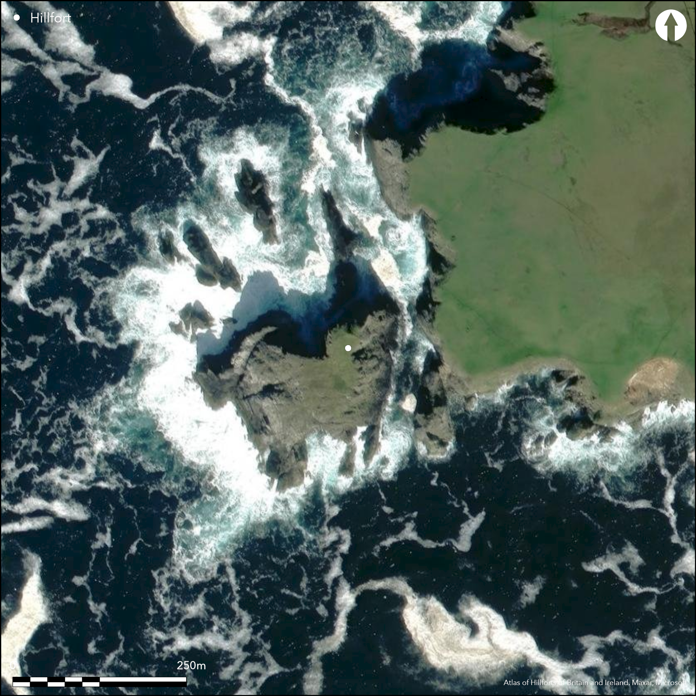
An isolated sea stack on the NW coast of Yell, which is now separated from the mainland by a chasm 55m wide and 40m deep, had traces of a substantial bank along its landward lip when first observed by Raymond Lamb in 1971 (1976, 153). No trace of this bank is visible on the available satellite imagery, which shows that the upper part of the sloping seaward side is made up of grass an rock across an irregular area measuring 55m from NE to SW by up to 40m transversely (0.18ha). Beyond this the rocks dip down to the sea over a distance of another 50m. On the landward side of the chasm two old dykes are visible and Lamb suggested that these related to the use of the headland before it became so heavily eroded and possibly when the stack was still connected to the mainland. Certainly the only way of accessing the stack in its present form would be to land by boat on the rocks on its seaward side. While Lamb speculated that this was an early monastic site, its character is quite unknown.
Citizen Science: ✗
Reliability of Data: Unconfirmed
Reliability of Interpretation: Unconfirmed
X: -125430 Y: 8561916 (EPSG: 3857)
Longitude: -1.126753654783875 Latitude: 60.72045543719479 (EPSG:4326)
Country: Scotland
Current County or Unitary Authority: Shetland Islands
Historic County: Shetland
Current Parish/Community/Council/Townland: Yell
None
| Extant | ✓ |
| Cropmark | ✗ |
| Likely Destroyed | ✗ |
None
| Woodland | ✗ |
| Commercial Forestry Plantation | ✗ |
| Parkland | ✗ |
| Pasture (Grazing) | ✗ |
| Arable | ✗ |
| Scrub/Bracken | ✗ |
| Bare Outcrop | ✗ |
| Heather/Moorland | ✓ |
| Heath | ✗ |
| Built-up | ✗ |
| Coastal Grassland | ✗ |
| Other | ✗ |
Now an isolated sea stack
| Contour Fort | ✗ |
| Partial Contour Fort | ✗ |
| Promontory Fort | ✓ |
| Hillslope Fort | ✗ |
| Level Terrain Fort | ✗ |
| Marsh Fort | ✗ |
| Multiple Enclosure Fort | ✗ |
| Hilltop | ✗ |
| Coastal Promontory | ✓ |
| Inland Promontory | ✗ |
| Valley Bottom | ✗ |
| Knoll/Hillock/Outcrop | ✗ |
| Ridge | ✗ |
| Cliff/Plateau-edge/Scarp | ✗ |
| Hillslope | ✗ |
| Lowland | ✗ |
| Spur | ✗ |
Dominant Topographic Feature: None
| North | ✗ |
| Northeast | ✗ |
| East | ✗ |
| Southeast | ✗ |
| South | ✗ |
| Southwest | ✗ |
| West | ✗ |
| Northwest | ✗ |
| Level | ✓ |
Altitude: 40.0m
N/A
In the absence of a site visit, the true character of the remains is unknown excavation, and with neither stratified artefacts nor radiocarbon dates to provide a chronology, its date remains unknown
Reliability: D - None
| Pre 1200BC | ✗ |
| 1200BC - 800BC | ✗ |
| 800BC - 400BC | ✗ |
| 400BC - AD50 | ✗ |
| AD50 - AD400 | ✗ |
| AD400 - AD 800 | ✗ |
| Post AD800 | ✗ |
| Unknown | ✓ |
| Pre Hillfort: | None |
| Post Hillfort: | None |
None
| 1st Identified Written Reference (1971): | Noted by Raymond Lamb (1976, 153; photographs from the neighbouring cliffs held by RCAHMS) |
| Other (2000): | Included in the Yell chapel-sites survey 1999-2000 conducted for GUARD by Kevin Brady (RCAHMS MS 1069/1 & 33) |
The impression of one possible rectangular building on the satellite imagery is perhaps more likely to be a reflection of the pattern of outcropping rock protruding through the grass
None
| None | ✓ |
| Spring | ✗ |
| Stream | ✗ |
| Pool | ✗ |
| Flush | ✗ |
| Well | ✗ |
| Other | ✗ |
None
| No Known Features | ✓ |
| Round Stone Structures | ✗ |
| Rectangular Stone Structures | ✗ |
| Curvilinear Platforms | ✗ |
| Other Roundhouse Evidence | ✗ |
| Pits | ✗ |
| Quarry Hollows | ✗ |
| Other | ✗ |
None
| No Known Excavation | ✓ |
| Pits | ✗ |
| Postholes | ✗ |
| Roundhouses | ✗ |
| Rectangular Structures | ✗ |
| Roads/Tracks | ✗ |
| Quarry Hollows | ✗ |
| Other | ✗ |
| Nothing Found | ✗ |
None
| No Known Geophysics | ✓ |
| Pits | ✗ |
| Roundhouses | ✗ |
| Rectangular Structures | ✗ |
| Roads/Tracks | ✗ |
| Quarry Hollows | ✗ |
| Other | ✗ |
| Nothing Found | ✗ |
None
| No Known Finds | ✓ |
| Pottery | ✗ |
| Metal | ✗ |
| Metalworking | ✗ |
| Human Bones | ✗ |
| Animal Bones | ✗ |
| Lithics | ✗ |
| Environmental | ✗ |
| Other | ✗ |
Impression of a single building, but its side walls may be no more than outcropping rock
| APs Not Checked | ✗ |
| None | ✗ |
| Roundhouses | ✗ |
| Rectangular Structures | ✗ |
| Pits | ✗ |
| Postholes | ✗ |
| Roads/Tracks | ✗ |
| Other | ✓ |
None known
| 0: | None |
| 2: | None known |
Guard Chambers: ✗
Chevaux de Frise: ✗
Single bank on the landward side
| Area 1: | 0.18ha. |
| Total: | 0.18ha. |
Total Footprint Area: 0.5ha.
None
| ✗ | None |
| ✗ | None |
| NE Quadrant: | 1 |
| SE Quadrant: | 0 |
| SW Quadrant: | 0 |
| NW Quadrant: | 0 |
| Total: | 1 |
| Partial Univallate | ✓ |
| Univallate | ✗ |
| Partial Bivallate | ✗ |
| Bivallate | ✗ |
| Partial Multivallate | ✗ |
| Multivallate | ✗ |
| Unknown | ✗ |
| Partial Univallate | ✗ |
| Univallate | ✗ |
| Partial Bivallate | ✗ |
| Bivallate | ✗ |
| Partial Multivallate | ✗ |
| Multivallate | ✗ |
None
| None | ✗ |
| Earthen Bank | ✓ |
| Stone Wall | ✗ |
| Rubble | ✗ |
| Wall-walk | ✗ |
| Evidence of Timber | ✗ |
| Vitrification | ✗ |
| Other Burning | ✗ |
| Palisade | ✗ |
| Counter Scarp Bank | ✗ |
| Berm | ✗ |
| Unfinished | ✗ |
| Other | ✗ |
None
| None | ✗ |
| Earthen Bank | ✗ |
| Stone Wall | ✗ |
| Murus Duplex | ✗ |
| Timber-framed | ✗ |
| Timber-laced | ✗ |
| Vitrification | ✗ |
| Other Burning | ✗ |
| Palisade | ✗ |
| Counter Scarp Bank | ✗ |
| Berm | ✗ |
| Unfinished | ✗ |
| No Known Excavation | ✓ |
| Other | ✗ |
| ✗ | None |
| ✗ | None |
Number of Ditches: None
| ✗ | None |
Lamb, R G (1976) 'The Burri Stacks of Culswick, Shetland, and other paired stack-settlements'. Proc Soc Antiq Scot 107 (1975-6), 144-54
Atlas of Hillforts:
Wikidata:
This work is licensed under CC BY-SA 4.0

 and should be cited as:
Lock, Gary and Ralston, Ian. 2024. Atlas of Hillforts of Britain and Ireland. Available at: https://hillforts.arch.ox.ac.uk
Document Version 1.1