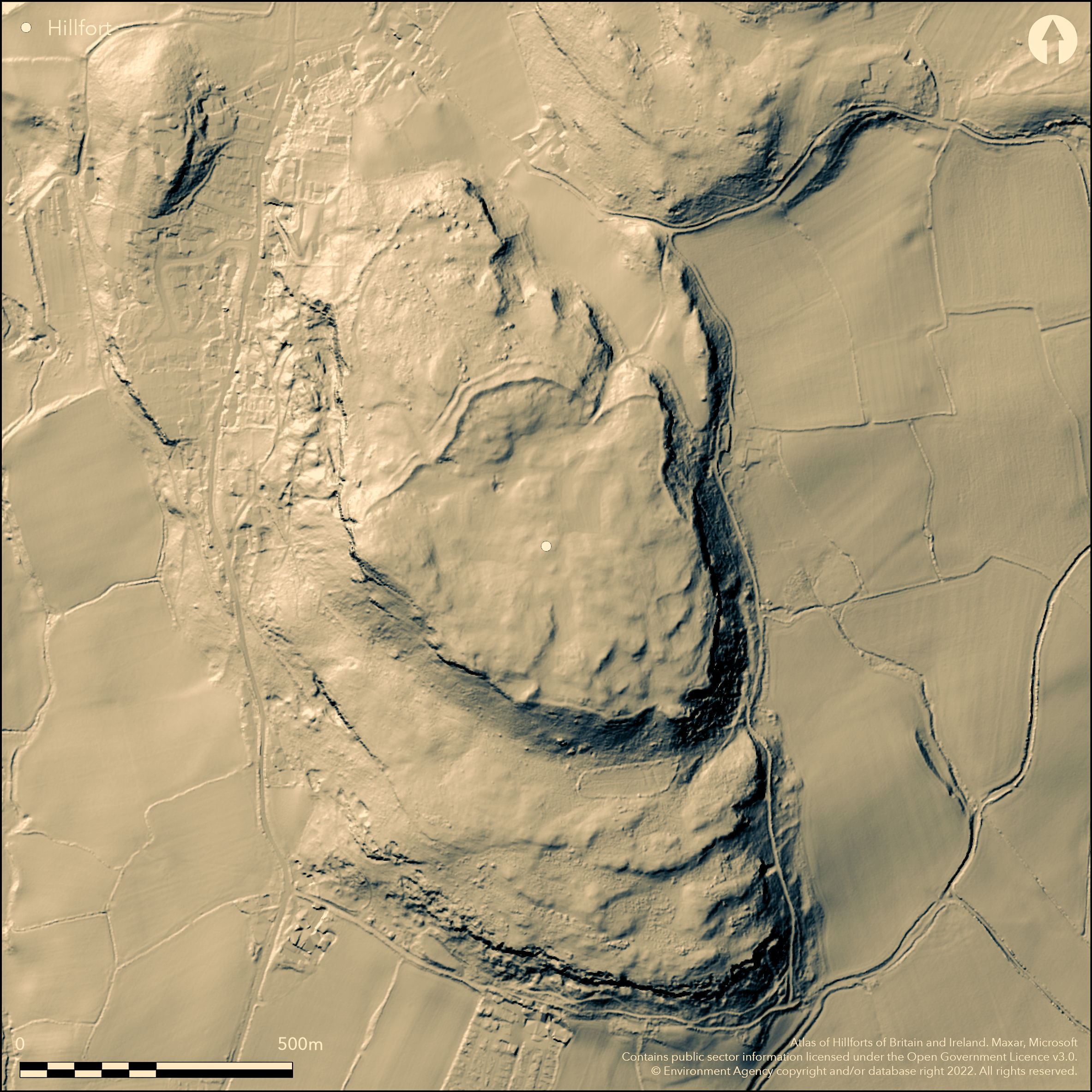
LiDAR 1m DTM Hillshade
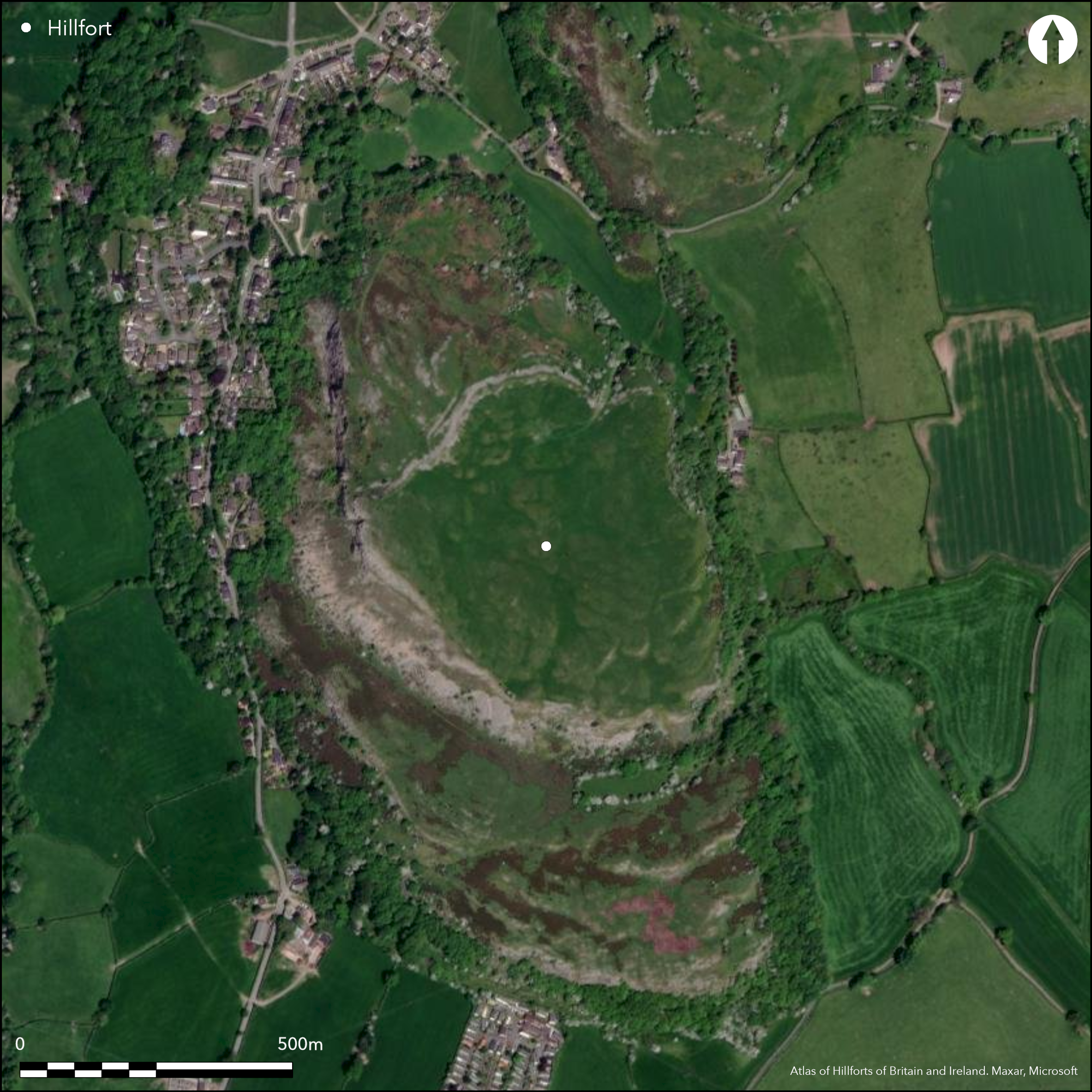
Satellite Imagery
LiDAR 1m DTM Hillshade
Satellite Imagery
Scroll left/right to view further images.
HER: Clwyd Powys 100491 (None)
NMR: SH 97 NW 12 (303515)
SM: DE008
NGR: SH91547637
X: 291540 Y: 376370 (OSGB36)
Fine, large, stone-built partial contour hillfort located commanding the Afon Dulas above coastal plain on North Wales coast and sea to N. Surrounding slopes moderate to strong on N and W, very steep/precipitous on E and S. Sub-oval shaped c. 400m SE-NW to by 100m-360m with main enclosure of c. 10ha and substantial annexe of 5.3ha on N and NW. Main enclosure defined by two stone-revetted ramparts c. 12m apart, with outside ditches but no intervening ditch. Annexe has single wall. Selected cuttings, particularly of NE gate, by Willoughby Gardner 1905. Three entrances, to NE, S and NW, to main enclosure, one to annexe to NW. NE and NW entrances inturned and good and sited at head of natural gullies and lengthened to form passageways with inner guard chambers. Vestiges of stone walling on NE entrance, but damaged. S entrance at top of very steep slope and possibly stepped in use. Postern gate to spring below on E. Annexe has simple entrance on NW. Possible hut sites visible from the air. Roman and medieval chance finds.Tumbled stone ramparts, but generally in good condition. Rough upland pasture, scrub and bare rock. On 1st Ed. OS map (1875). Undated.
Citizen Science: ✗
Reliability of Data: Confirmed
Reliability of Interpretation: Confirmed
X: -403861 Y: 7033689 (EPSG: 3857)
Longitude: -3.627942305718869 Latitude: 53.273176848854845 (EPSG:4326)
Country: Wales
Current County or Unitary Authority: Conwy
Historic County: Denbighshire
Current Parish/Community/Council/Townland: Llanddulas and Rhyd-y-foel
Tumbled stone ramparts, but generally in good condition. NE entrance damaged in1980's.
| Extant | ✓ |
| Cropmark | ✗ |
| Likely Destroyed | ✗ |
Rough upland pasture, scrub and bare rock.
| Woodland | ✗ |
| Commercial Forestry Plantation | ✗ |
| Parkland | ✗ |
| Pasture (Grazing) | ✓ |
| Arable | ✗ |
| Scrub/Bracken | ✓ |
| Bare Outcrop | ✗ |
| Heather/Moorland | ✗ |
| Heath | ✗ |
| Built-up | ✗ |
| Coastal Grassland | ✗ |
| Other | ✗ |
Fine, large, stone-built partial contour hillfort located in commanding the Afon Dulas above coastal plain and sea to N.Surrounding slopes moderate to strong on N and W, very steep/precipitous on E and S.
| Contour Fort | ✗ |
| Partial Contour Fort | ✓ |
| Promontory Fort | ✗ |
| Hillslope Fort | ✗ |
| Level Terrain Fort | ✗ |
| Marsh Fort | ✗ |
| Multiple Enclosure Fort | ✗ |
| Hilltop | ✓ |
| Coastal Promontory | ✗ |
| Inland Promontory | ✗ |
| Valley Bottom | ✗ |
| Knoll/Hillock/Outcrop | ✗ |
| Ridge | ✗ |
| Cliff/Plateau-edge/Scarp | ✗ |
| Hillslope | ✗ |
| Lowland | ✗ |
| Spur | ✗ |
Dominant Topographic Feature: Hill top
| North | ✗ |
| Northeast | ✗ |
| East | ✗ |
| Southeast | ✗ |
| South | ✓ |
| Southwest | ✗ |
| West | ✗ |
| Northwest | ✓ |
| Level | ✗ |
Altitude: 170.0m
N/A
Undated. Chance find of Roman end-buckle c. AD 370-400. Early and late Roman material found in excavations. Chance find of early medieval (8th century) pseudo-pennanular brooch. Roman coin hoards of 3rd and 4th century AD found near fort.
Reliability: D - None
| Pre 1200BC | ✗ |
| 1200BC - 800BC | ✗ |
| 800BC - 400BC | ✗ |
| 400BC - AD50 | ✗ |
| AD50 - AD400 | ✗ |
| AD400 - AD 800 | ✗ |
| Post AD800 | ✗ |
| Unknown | ✓ |
| Pre Hillfort: | None |
| Post Hillfort: | Roman and medieval chance finds. |
| Artefactual: | Early and late Roman material found in excavations. |
On 1st Ed. OS map (1875). Selected cuttings, particularly of NE gate, with gate plans and structural details, by Willoughby Gardner 1905.
| 1st Identified Map Depiction (1875): | OS map. |
| Excavation (1905): | Willoughby Gardner. |
Selected cuttings show plan and structural details, particularly of NE gate, with guard chambers and recessed postholes.Possible hut sites visible from the air. Sherd of Roman pottery from 1905 excavation. Chance find of Roman end-buckle of c. AD 370-400. Chance find of early medieval (eighth century) pseudo-pennanular brooch. Roman votive objects found at Llys Awel below fort.
Spring below fort on E.
| None | ✓ |
| Spring | ✗ |
| Stream | ✗ |
| Pool | ✗ |
| Flush | ✗ |
| Well | ✗ |
| Other | ✗ |
Possible hut platforms visible.
| No Known Features | ✗ |
| Round Stone Structures | ✗ |
| Rectangular Stone Structures | ✗ |
| Curvilinear Platforms | ✓ |
| Other Roundhouse Evidence | ✗ |
| Pits | ✗ |
| Quarry Hollows | ✗ |
| Other | ✗ |
Selected cuttings show plan and structural details, particularly of NE gate, with guard chambers and recessed postholes.
| No Known Excavation | ✗ |
| Pits | ✗ |
| Postholes | ✓ |
| Roundhouses | ✗ |
| Rectangular Structures | ✗ |
| Roads/Tracks | ✗ |
| Quarry Hollows | ✗ |
| Other | ✓ |
| Nothing Found | ✗ |
None
| No Known Geophysics | ✓ |
| Pits | ✗ |
| Roundhouses | ✗ |
| Rectangular Structures | ✗ |
| Roads/Tracks | ✗ |
| Quarry Hollows | ✗ |
| Other | ✗ |
| Nothing Found | ✗ |
Sherd of Roman pottery from 1905 excavation. Chance find of Roman end-buckle of c. AD 370-400. Roman votive objects found at Llys Awel below fort. Chance find of early medieval (8th century) pseudo-pennanular brooch.
| No Known Finds | ✗ |
| Pottery | ✓ |
| Metal | ✓ |
| Metalworking | ✗ |
| Human Bones | ✗ |
| Animal Bones | ✗ |
| Lithics | ✗ |
| Environmental | ✗ |
| Other | ✗ |
Possible hut sites visible from the air.
| APs Not Checked | ✗ |
| None | ✗ |
| Roundhouses | ✓ |
| Rectangular Structures | ✗ |
| Pits | ✗ |
| Postholes | ✗ |
| Roads/Tracks | ✗ |
| Other | ✗ |
Three entrances, to NE, S and NW, to main enclosure, one to annexe to NW. N and NW entrances inturned and good and sited at head of natural gullies and lengthened to form passageways with inner guard chambers. Vestiges of stone walling on NE entrance, but damaged. S entrance at top of very steep slope and possibly stepped in use. Postern gate to spring below on E where votive objects found. Selected cuttings show plan and structural details of NE gate.
| 5: | None |
| 2: | Three entrances to main enclosure, one to annexe. Postern gate to E. |
Guard Chambers: ✓
Chevaux de Frise: ✗
| 1. In-turned (North east): | Sited at head of natural gully/hollow way. |
| 1. Hollow Way (North east): | Long hollow way/gully. |
| 1. Recesses/Guard Chambers (North east): | None |
| 2. Simple Gap (South): | Sited at top of very steep slope and possibly stepped. |
| 2. Simple Gap (South): | Sited at top of very steep slope and possibly stepped. |
| 3. In-turned (North west): | Sited at head of natural gully/hollow way. |
| 3. Hollow Way (North west): | Natural gully/hollow way. |
| 4. Simple Gap (North west): | Annexe entrance. |
| 5. Simple Gap (East): | Postern gate. |
Main enclosure defined by two stone-revetted ramparts c. 12m apart, with outside ditch but no intervening ditch.
| Area 1: | 15.3ha. |
| Total: | 15.3ha. |
Total Footprint Area: Noneha.
None
| ✗ | None |
| ✓ | Annexe rampart not included in quadrants on N. |
| NE Quadrant: | 2 |
| SE Quadrant: | 2 |
| SW Quadrant: | 2 |
| NW Quadrant: | 2 |
| Total: | 2 |
| Partial Univallate | ✗ |
| Univallate | ✗ |
| Partial Bivallate | ✗ |
| Bivallate | ✓ |
| Partial Multivallate | ✗ |
| Multivallate | ✗ |
| Unknown | ✗ |
| Partial Univallate | ✗ |
| Univallate | ✗ |
| Partial Bivallate | ✗ |
| Bivallate | ✗ |
| Partial Multivallate | ✗ |
| Multivallate | ✗ |
Tumbled stone walls.
| None | ✗ |
| Earthen Bank | ✗ |
| Stone Wall | ✓ |
| Rubble | ✗ |
| Wall-walk | ✗ |
| Evidence of Timber | ✗ |
| Vitrification | ✗ |
| Other Burning | ✗ |
| Palisade | ✗ |
| Counter Scarp Bank | ✗ |
| Berm | ✗ |
| Unfinished | ✗ |
| Other | ✗ |
Selected cuttings show plan and structural details, particularly of NE gate.
| None | ✗ |
| Earthen Bank | ✗ |
| Stone Wall | ✓ |
| Murus Duplex | ✗ |
| Timber-framed | ✗ |
| Timber-laced | ✗ |
| Vitrification | ✗ |
| Other Burning | ✗ |
| Palisade | ✗ |
| Counter Scarp Bank | ✗ |
| Berm | ✗ |
| Unfinished | ✗ |
| No Known Excavation | ✗ |
| Other | ✓ |
| ✗ | None |
| ✓ | Outside ditch. |
Number of Ditches: 1
| ✓ | Substantial annexe adds c. 200m to site and 5.3ha on N and NW with single wall and simple annexe on NW. |
Brown, I. 2009. Beacons in the landscape. The hillforts of England and Wales, Oxford: Windgather Press/Oxbow Books.
Burnham, H. 1995. A guide to ancient and historic Wales - Clwyd and Powys, London: HMSO, 193.
Gale, F. 1991. The Iron Age, in eds Manley, J., Grenter, S. and Gale, F., The archaeology of Clwyd, Mold: Clwyd Archaeology Service, Clwyd County Council.
Gardner, W. 1910. Pen y corddyn, near Abergele, Arch Camb, 10, 79-156.
Sanderson, I. 1992. Exciting find helps throw light on 'Dark Ages', Clwyd Archaeology News, Winter 1992/3, 2.
Atlas of Hillforts:
Wikidata:
This work is licensed under CC BY-SA 4.0

 and should be cited as:
Lock, Gary and Ralston, Ian. 2024. Atlas of Hillforts of Britain and Ireland. Available at: https://hillforts.arch.ox.ac.uk
Document Version 1.1