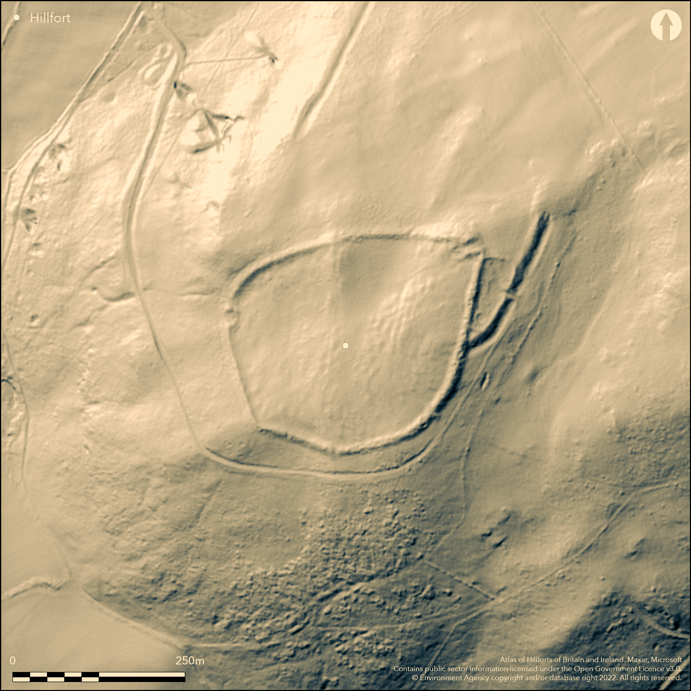
LiDAR 1m DTM Hillshade
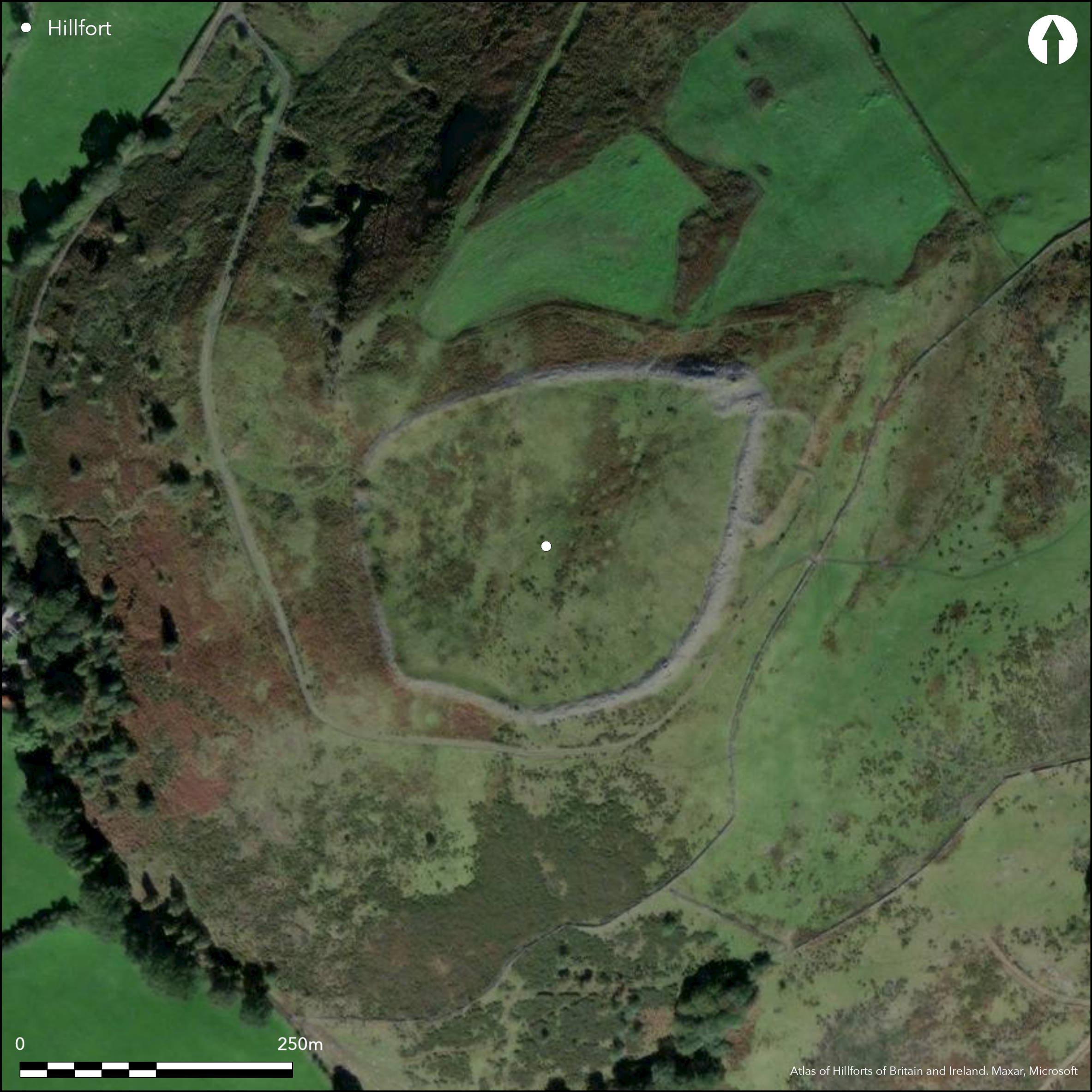
Satellite Imagery
LiDAR 1m DTM Hillshade
Satellite Imagery
Scroll left/right to view further images.
HER: Clwyd Powys 100810 (None)
NMR: SJ 04 SE (95431)
SM: None
NGR: SJ0876544395
X: 308765 Y: 344395 (OSGB36)
Complex, part contour/hillslope hillfort set on W-facing sloping ground below the summit of a long ridge extending W into the lowlands of the Dee Valley N of Corwen. Overlooking the River Dee and its confluence with the Afon Morwynion and routes N, E and W. Steep slopes to N, S and W, moderate upslope to E. Measures c. 192m N-S by 215m overall, with internal area c. 3.45ha. Detailed topographical and geophysical surveys by Engineering Archaeological Services and Oxford University. Probably three phases recognised. First possibly comprised small enclosure of bank and ditch with slightly inturned E entrance, extending to 0.55ha at highest E end of site. Sometimes called an 'annexe', as appears attached to outer main rampart. Its has been suggested by Brooks and Laws (2006) that this earlier enclosure was overlain by the massive, stepped, stone-walled E rampart of the main enclosure in a second phase to the site and which extended downslope to c. half of present enclosure. Exceptional NE long inturned entrance with guard chamber. A third phase had this extended downslope as an earthen/rubble rampart to complete the present circuit of 2.9ha on the W with simple W entrance. At least three definite roundhouses visible in small enclosure to E and topographical survey suggested at least eight possible hut platforms in the main enclosure. However, subsequent geophysical survey of substantial proportion of the main enclosure, and several of these potential hut platforms, resulted in no evidence of structures. The interior appears empty, but there could be structures immediately inside the main enclosure E rampart. Hillfort constituent part of the Heather and Hillforts Landscape Partnership Scheme, funded by the Heritage Lottery fund of Denbighshire County Council 2006-2011, included the topographical and geophysical surveys, interpretation and visitor management works. Rough upland pasture. Gorse and bracken managed. Well managed council ownership and in general good condition. On 1st Ed. OS map (1875). Undated.
Citizen Science: ✗
Reliability of Data: Confirmed
Reliability of Interpretation: Confirmed
X: -374102 Y: 6980978 (EPSG: 3857)
Longitude: -3.360614006892356 Latitude: 52.98907654278501 (EPSG:4326)
Country: Wales
Current County or Unitary Authority: Denbighshire
Historic County: Merioneth
Current Parish/Community/Council/Townland: Corwen
Fallen ramparts in general good order with exposed stonework, but modern damage and built cairn at NE entrance at summit. In well-managed Denbighshire County Council ownership. Upland track leads to fort. Modern access track around part of site.
| Extant | ✓ |
| Cropmark | ✗ |
| Likely Destroyed | ✗ |
Rough upland pasture. Gorse and bracken managed. Bare rock outcrops.
| Woodland | ✗ |
| Commercial Forestry Plantation | ✗ |
| Parkland | ✗ |
| Pasture (Grazing) | ✓ |
| Arable | ✗ |
| Scrub/Bracken | ✓ |
| Bare Outcrop | ✗ |
| Heather/Moorland | ✗ |
| Heath | ✗ |
| Built-up | ✗ |
| Coastal Grassland | ✗ |
| Other | ✗ |
Fine partial contour hillfort, set on W-facing sloping ground below the summit of a long ridge extending W into the lowlands of the Dee Valley N of Corwen. In strategic location overlooking the River Dee and its confluence with the Afon Morwynion and routes N, E and W. Steep slopes to N, S and W, moderate upslope to E.
| Contour Fort | ✗ |
| Partial Contour Fort | ✓ |
| Promontory Fort | ✗ |
| Hillslope Fort | ✓ |
| Level Terrain Fort | ✗ |
| Marsh Fort | ✗ |
| Multiple Enclosure Fort | ✗ |
| Hilltop | ✗ |
| Coastal Promontory | ✗ |
| Inland Promontory | ✗ |
| Valley Bottom | ✗ |
| Knoll/Hillock/Outcrop | ✗ |
| Ridge | ✓ |
| Cliff/Plateau-edge/Scarp | ✗ |
| Hillslope | ✓ |
| Lowland | ✗ |
| Spur | ✗ |
Dominant Topographic Feature: Hillslope
| North | ✗ |
| Northeast | ✗ |
| East | ✗ |
| Southeast | ✗ |
| South | ✗ |
| Southwest | ✗ |
| West | ✓ |
| Northwest | ✗ |
| Level | ✗ |
Altitude: 294.0m
N/A
None
Reliability: D - None
| Pre 1200BC | ✗ |
| 1200BC - 800BC | ✗ |
| 800BC - 400BC | ✗ |
| 400BC - AD50 | ✗ |
| AD50 - AD400 | ✗ |
| AD400 - AD 800 | ✗ |
| Post AD800 | ✗ |
| Unknown | ✓ |
| Pre Hillfort: | None |
| Post Hillfort: | None |
First mentioned c.1600 where construction attributed to a hero or giant Drewyn Gawr. In Aubrey's Monumenta Britannica (1665-1693). On 1st Ed. OS map (1875). Investigated by Pritchard and Willoughby Gardner in the later nineteenth and earlier twentieth century, when sections of ramparts cleared. There were no datable finds. It is generally believed that Owain Glyndwr made use of Caer Drewyn as an occasional retreat (Pennant). Hillfort constituent part of the Heather and Hillforts Landscape Partnership Scheme, funded by the Heritage Lottery fund of Denbighshire County Council 2006-2011. Geophysical survey Oxford University 2008. Topographical and geophysical surveys Engineering Archaeological Services 2006 and with Oxford University 2011.
| 1st Identified Written Reference (1600): | Referred to in 1921 RCAHM inventory of Denbighshire. |
| 1st Identified Map Depiction (1875): | OS map. |
| Other (1977): | Visit by Hillfort Study Group |
| Geophysical Survey (2006): | Engineering Archaeological Services. |
| Earthwork Survey (2006): | Engineering Archaeological Services. |
| Geophysical Survey (2008): | I. Brown and W. Wintle, Oxford University. |
| Geophysical Survey (2011): | Engineering Archaeological Services with Oxford University. |
| Other (2012): | Visited by Hillfort Study Group |
| Other (None): | Aubrey's Monumenta Britannica. |
| Other (None): | Heather and Hillforts Landscape Partnership Scheme. |
| Other (None): | Pritchard and Willoughby Gardner. |
Some eight platforms identified as possibly hut sites, but uncertain and could be quarry scrapes. Possible structures immediately inside E rampart. At least three roundhouses in 'annexe'. Geophysical surveys suggest interior of main enclosure devoid of structures.
Spring immediately below fort.
| None | ✓ |
| Spring | ✗ |
| Stream | ✗ |
| Pool | ✗ |
| Flush | ✗ |
| Well | ✗ |
| Other | ✗ |
Some eight platforms identified as possibly hut sites, but uncertain and could be quarry scrapes. Possible structures immediately inside E rampart. At least three roundhouses in 'annexe'. Possible quarry hollows.
| No Known Features | ✗ |
| Round Stone Structures | ✗ |
| Rectangular Stone Structures | ✗ |
| Curvilinear Platforms | ✓ |
| Other Roundhouse Evidence | ✓ |
| Pits | ✗ |
| Quarry Hollows | ✓ |
| Other | ✗ |
None
| No Known Excavation | ✓ |
| Pits | ✗ |
| Postholes | ✗ |
| Roundhouses | ✗ |
| Rectangular Structures | ✗ |
| Roads/Tracks | ✗ |
| Quarry Hollows | ✗ |
| Other | ✗ |
| Nothing Found | ✗ |
Geophysical surveys suggest interior devoid of structures.Roundhouse evidence in 'annexe'.
| No Known Geophysics | ✗ |
| Pits | ✗ |
| Roundhouses | ✓ |
| Rectangular Structures | ✗ |
| Roads/Tracks | ✗ |
| Quarry Hollows | ✗ |
| Other | ✗ |
| Nothing Found | ✗ |
None
| No Known Finds | ✓ |
| Pottery | ✗ |
| Metal | ✗ |
| Metalworking | ✗ |
| Human Bones | ✗ |
| Animal Bones | ✗ |
| Lithics | ✗ |
| Environmental | ✗ |
| Other | ✗ |
None
| APs Not Checked | ✓ |
| None | ✗ |
| Roundhouses | ✗ |
| Rectangular Structures | ✗ |
| Pits | ✗ |
| Postholes | ✗ |
| Roads/Tracks | ✗ |
| Other | ✗ |
Two original entrances with at least one modern gap. Fine inturned passageway entrance with guard chamber(s) on NE. Simple gap entrance on SW possible more elaborate than appears.
| 3: | At least one modern gap. |
| 2: | None |
Guard Chambers: ✓
Chevaux de Frise: ✗
| 1. In-turned (North east): | Long passageway |
| 1. Passage-way/Corridor (North east): | Long passageway. |
| 1. Recesses/Guard Chambers (North east): | None |
| 2. Simple Gap (South west): | Possibly more than simple gap. |
| 2. Simple Gap (South west): | Possibly more than simple gap. |
Possible phased construction with earlier banked and ditched enclosure (the 'annexe'), now attached to E main rampart. Second phase of massive, stepped stone-wall site downhill, with third phase of earth and stone bank further downslope to W. No ditch to main enclosure, but 'annexe' shows, probably rock-cut, ditch.
| Area 1: | 0.55ha. |
| Area 2: | 2.9ha. |
| Area 3: | 3.45ha. |
| Total: | 3.45ha. |
Total Footprint Area: Noneha.
None
| ✓ | Possibly three main phases of construction. |
| ✓ | Quadrants do not include 'annexe'. |
| NE Quadrant: | 1 |
| SE Quadrant: | 1 |
| SW Quadrant: | 1 |
| NW Quadrant: | 1 |
| Total: | 1 |
| Partial Univallate | ✗ |
| Univallate | ✓ |
| Partial Bivallate | ✗ |
| Bivallate | ✗ |
| Partial Multivallate | ✗ |
| Multivallate | ✗ |
| Unknown | ✗ |
| Partial Univallate | ✗ |
| Univallate | ✗ |
| Partial Bivallate | ✗ |
| Bivallate | ✗ |
| Partial Multivallate | ✗ |
| Multivallate | ✗ |
Evidence of wall-walk. Stone faces visible.
| None | ✗ |
| Earthen Bank | ✓ |
| Stone Wall | ✓ |
| Rubble | ✗ |
| Wall-walk | ✓ |
| Evidence of Timber | ✗ |
| Vitrification | ✗ |
| Other Burning | ✗ |
| Palisade | ✗ |
| Counter Scarp Bank | ✗ |
| Berm | ✗ |
| Unfinished | ✗ |
| Other | ✗ |
None
| None | ✗ |
| Earthen Bank | ✗ |
| Stone Wall | ✗ |
| Murus Duplex | ✗ |
| Timber-framed | ✗ |
| Timber-laced | ✗ |
| Vitrification | ✗ |
| Other Burning | ✗ |
| Palisade | ✗ |
| Counter Scarp Bank | ✗ |
| Berm | ✗ |
| Unfinished | ✗ |
| No Known Excavation | ✓ |
| Other | ✗ |
| ✗ | None |
| ✓ | No ditch to main enclosure, but 'annexe' shows, probably rock-cut, ditch. |
Number of Ditches: 1
| ✓ | Possible 'annexe' on NE side, but possibly earlier banked and ditched enclosure. |
Brooks, I.P. and Laws, K. 2006. Topographical and geophysical surveys of Caer Drewyn Hillfort, EAS Client Report.
Brooks, I.P. 2011. Survey report: Fron Newydd and Caer Drewyn, EAS Survey Report 2011/2012.
Brown, I. and Wintle, W. 2008. Geophysical survey of Caer Drewyn Hillfort, Denbighshire, October 2008 - Interim results, Institute of Archaeology unpublished report, Oxford.
Brown, I. 2009. Beacons in the landscape. The hillforts of England and Wales, Oxford: Windgather Press/Oxbow Books.
Driver,T. 2011. The Hillforts, In ed Mrowiec, H., Heather and Hillforts of the Clwydian Range and Llantysilio Mountains, Ruthin: Heather and Hillforts Partnership Board, Denbighshire County Council.
Gardner, W. 1922. The ancient hill fort known as Caer Drewyn, Merionethshire, Arch Camb, 77, 108-125.
Royal Commission on the Ancient and Historical Monuments and Constructions in Wales and Monmouthshire 1921. An inventory of the ancient monuments in Wales and Monmouthshire, IV, County of Merioneth, London: HMSO.
Atlas of Hillforts:
Wikidata:
This work is licensed under CC BY-SA 4.0

 and should be cited as:
Lock, Gary and Ralston, Ian. 2024. Atlas of Hillforts of Britain and Ireland. Available at: https://hillforts.arch.ox.ac.uk
Document Version 1.1