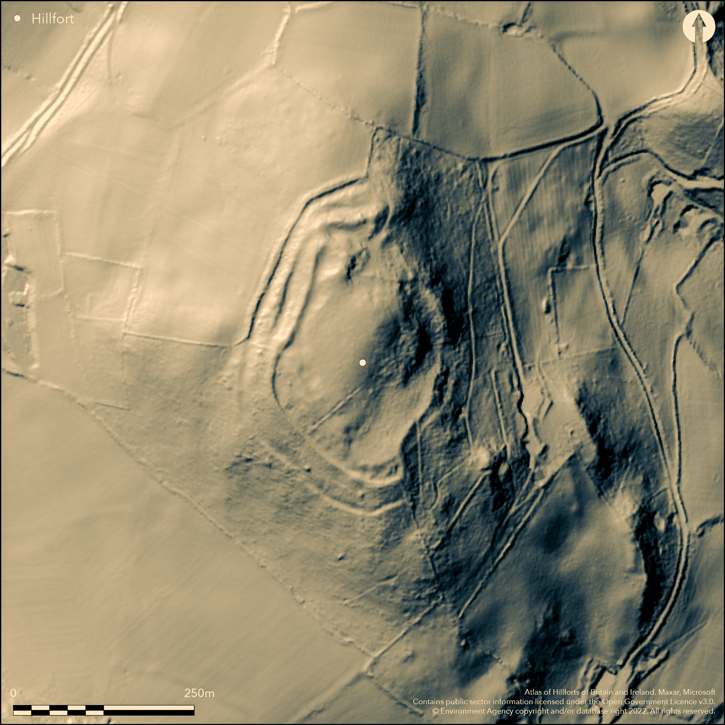
LiDAR 1m DTM Hillshade
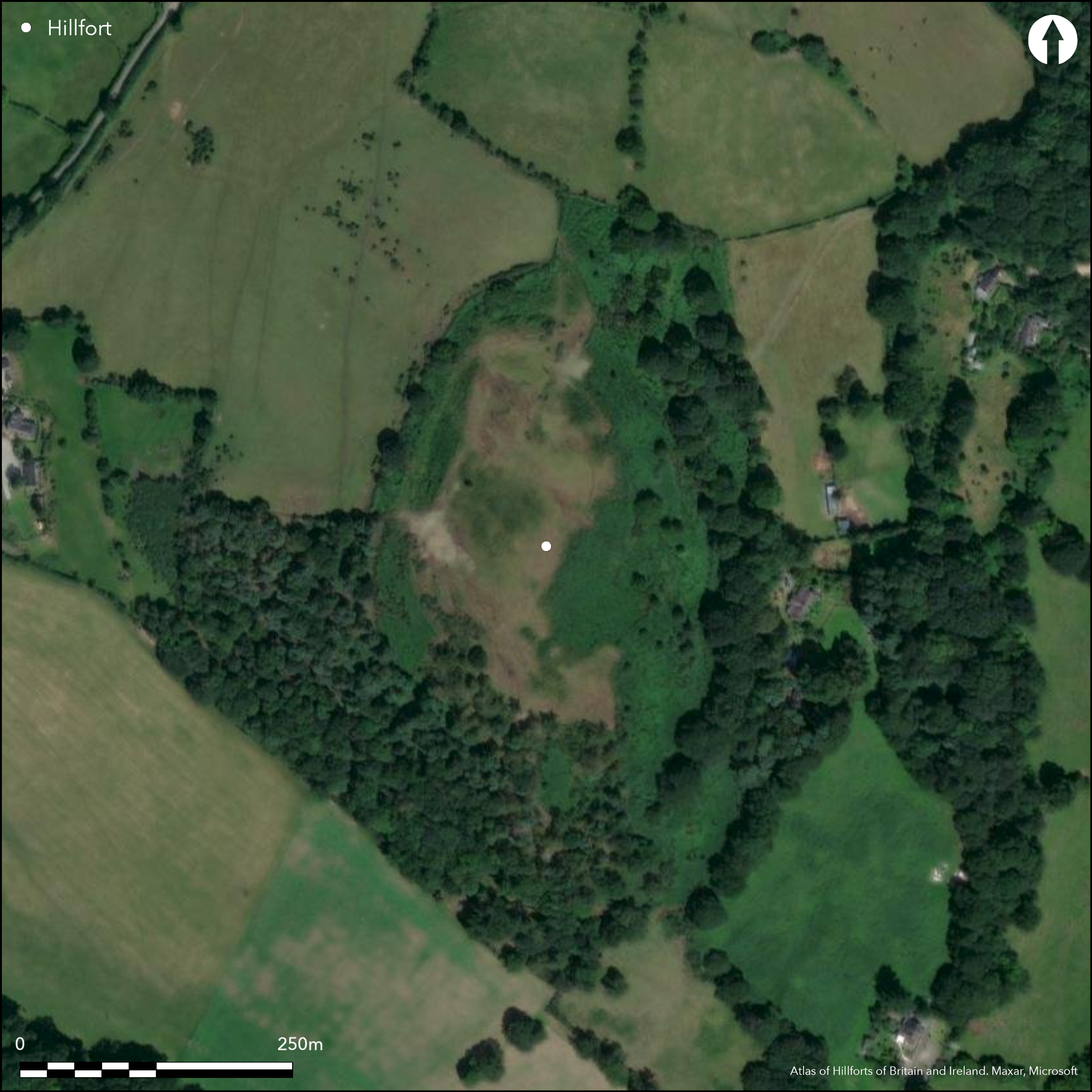
Satellite Imagery
LiDAR 1m DTM Hillshade
Satellite Imagery
Scroll left/right to view further images.
HER: Clwyd Powys 57565 (None)
NMR: SJ 07 SE 6 (306682)
SM: FL073
NGR: SJ09527080
X: 309520 Y: 370800 (OSGB36)
Partial contour hillfort located on a prominent hill in an outstanding strategic position at the confluence of the Afon Chwiler valley with the Vale of Clwyd, a major routeway through the Clwydian Range. Lowest in altitude of the Clwydian Range hillforts, but its positioning and ramparts make full use of the topography. Precipitous slopes to the S and E, very steep to the W, but less so to the N. Measures c. 241m N-S by 60m-125m, with internal area c. 1.8ha. Two ramparts and ditches with counterscarp bank go from the inturned N entrance around the W side. Quarry hollows inside the W ramparts. The configuration around the E and S sides is not clear due to an excessive amount of ice-plucking of the slopes and post-medieval quarrying. The W terminal of the N entrance is enlargened and T-shaped. Small-scale excavations in 1908 (Stapleton 1909) showed the inner ditch to be rock-cut and V-shaped and 2.5m deep and suggested an entrance to the W. Excavations by the University of Oxford (started in 2011 and ongoing - Lock and Pouncett 2012; 2014) included LiDAR analysis and extensive geophysics. Excavation showed the middle rampart to be stone-built and possibly multi-phased, c5m wide. A roundhouse shown by geophysics and located on an artificial terrace inside the N entrance was also excavated although the evidence for its construction was minimal. There is a possibility that the site is of two phases, the first a smaller univallate enclosure with later multi-vallation and monumental N entrance (excavations from 2016 onwards are exploring this). Possibly Roman intaglio and stone spindle whorl as surface finds, two further spindle whorls from excavation. A section of the W middle rampart was re-used by post-medieval landscaping. On 1st Edition OS map (1885-1900). Dated to the Iron Age based on rampart morphology and a single C14 date (367-183 cal BC) from bone within the bank associated with the roundhouse platform.
Citizen Science: ✗
Reliability of Data: Confirmed
Reliability of Interpretation: Confirmed
X: -373679 Y: 7025004 (EPSG: 3857)
Longitude: -3.356819067686387 Latitude: 53.226497928263925 (EPSG:4326)
Country: Wales
Current County or Unitary Authority: Denbighshire
Historic County: Flintshire
Current Parish/Community/Council/Townland: Bodfari
Well-preserved condition.
| Extant | ✓ |
| Cropmark | ✗ |
| Likely Destroyed | ✗ |
Upland pasture, scrub and bare rock. SSSI.
| Woodland | ✗ |
| Commercial Forestry Plantation | ✗ |
| Parkland | ✗ |
| Pasture (Grazing) | ✓ |
| Arable | ✗ |
| Scrub/Bracken | ✓ |
| Bare Outcrop | ✗ |
| Heather/Moorland | ✗ |
| Heath | ✗ |
| Built-up | ✗ |
| Coastal Grassland | ✗ |
| Other | ✗ |
Fine partial contour hillfort located on a prominent hill in an outstanding strategic position controlling access to the Afon Chwiler valley from the Vale of Clwyd, a major routeway through the Clwydian Range, and the confluence of the Afon Clwyd and Afon Chwiler. Lowest in altitude of the Clwydian Range hillforts, but its positioning and ramparts make full use of the topography. Precipitous slopes to the S and E, very steep to the W, but less so to the N,
| Contour Fort | ✗ |
| Partial Contour Fort | ✓ |
| Promontory Fort | ✗ |
| Hillslope Fort | ✗ |
| Level Terrain Fort | ✗ |
| Marsh Fort | ✗ |
| Multiple Enclosure Fort | ✗ |
| Hilltop | ✓ |
| Coastal Promontory | ✗ |
| Inland Promontory | ✗ |
| Valley Bottom | ✗ |
| Knoll/Hillock/Outcrop | ✗ |
| Ridge | ✗ |
| Cliff/Plateau-edge/Scarp | ✗ |
| Hillslope | ✗ |
| Lowland | ✗ |
| Spur | ✗ |
Dominant Topographic Feature: Hill top
| North | ✗ |
| Northeast | ✗ |
| East | ✗ |
| Southeast | ✗ |
| South | ✗ |
| Southwest | ✗ |
| West | ✓ |
| Northwest | ✗ |
| Level | ✗ |
Altitude: 206.0m
N/A
Dated to the Iron Age based on rampart morphology and a single C14 date (367-183 cal BC) from bone within the bank associated with the roundhouse platform. Post-medieval quarrying and landscaping.
Reliability: B - Medium
| Pre 1200BC | ✗ |
| 1200BC - 800BC | ✗ |
| 800BC - 400BC | ✗ |
| 400BC - AD50 | ✓ |
| AD50 - AD400 | ✗ |
| AD400 - AD 800 | ✗ |
| Post AD800 | ✗ |
| Unknown | ✗ |
| Pre Hillfort: | None |
| Post Hillfort: | None |
| Morphology/Earthwork/Typology: | None |
On 1st Edition OS map (1885-1900). Excavation 1908 (Stapleton). Geophysics, LiDAR and earthwork survey 2011, excavation 2012 and ongoing (Lock and Pouncett).
| Excavation (1908): | None |
| LiDAR Survey (2011): | None |
| Geophysical Survey (2011): | None |
| Earthwork Survey (2011): | None |
| Other (2012): | Visited by Hillfort Study Group |
| 1st Identified Map Depiction (None): | None |
| Excavation (None): | None |
Artificial terrace inside N entrance, roundhouse shown by geophysics and excavation, possible pits in the interior. Quarry hollows inside W ramparts. Possibly Roman intaglio and stone spindle whorl as surface finds, two further spindle whorls from excavation.
None
| None | ✓ |
| Spring | ✗ |
| Stream | ✗ |
| Pool | ✗ |
| Flush | ✗ |
| Well | ✗ |
| Other | ✗ |
None
| No Known Features | ✗ |
| Round Stone Structures | ✗ |
| Rectangular Stone Structures | ✗ |
| Curvilinear Platforms | ✗ |
| Other Roundhouse Evidence | ✓ |
| Pits | ✗ |
| Quarry Hollows | ✓ |
| Other | ✗ |
None
| No Known Excavation | ✗ |
| Pits | ✓ |
| Postholes | ✗ |
| Roundhouses | ✓ |
| Rectangular Structures | ✗ |
| Roads/Tracks | ✗ |
| Quarry Hollows | ✓ |
| Other | ✗ |
| Nothing Found | ✗ |
None
| No Known Geophysics | ✗ |
| Pits | ✓ |
| Roundhouses | ✓ |
| Rectangular Structures | ✗ |
| Roads/Tracks | ✗ |
| Quarry Hollows | ✓ |
| Other | ✗ |
| Nothing Found | ✗ |
None
| No Known Finds | ✗ |
| Pottery | ✗ |
| Metal | ✗ |
| Metalworking | ✗ |
| Human Bones | ✗ |
| Animal Bones | ✗ |
| Lithics | ✗ |
| Environmental | ✗ |
| Other | ✓ |
None
| APs Not Checked | ✗ |
| None | ✓ |
| Roundhouses | ✗ |
| Rectangular Structures | ✗ |
| Pits | ✗ |
| Postholes | ✗ |
| Roads/Tracks | ✗ |
| Other | ✗ |
On N, awkward to enter making full use of natural drops. Gap through inner rampart similar to that at Moel Arthur with T-shaped enlargenment of rampart at the inturn only allowing access via a narrow path. Possible W entrance.
| 2: | None |
| 2: | Possibly two entrances. |
Guard Chambers: ✗
Chevaux de Frise: ✗
| 1. In-turned (North): | None |
| 2. Simple Gap (West): | None |
Two ramparts and ditches with counterscarp bank go from the inturned N entrance around the W side. The configuration around the E and S sides is not clear due to an excessive amount of ice-plucking of the slopes and post-medieval quarrying. Excavation showed the middle rampart to be stone-built and possibly multi-phased, c5m wide, ditch rock-cut, V-shaped and 2.5m deep.
| Area 1: | 1.8ha. |
| Total: | 1.8ha. |
Total Footprint Area: Noneha.
None
| ✓ | Possible two phases. |
| ✗ | None |
| NE Quadrant: | 1 |
| SE Quadrant: | 1 |
| SW Quadrant: | 2 |
| NW Quadrant: | 2 |
| Total: | 2 |
| Partial Univallate | ✓ |
| Univallate | ✗ |
| Partial Bivallate | ✓ |
| Bivallate | ✗ |
| Partial Multivallate | ✗ |
| Multivallate | ✗ |
| Unknown | ✗ |
| Partial Univallate | ✗ |
| Univallate | ✓ |
| Partial Bivallate | ✗ |
| Bivallate | ✗ |
| Partial Multivallate | ✗ |
| Multivallate | ✗ |
None
| None | ✗ |
| Earthen Bank | ✓ |
| Stone Wall | ✗ |
| Rubble | ✗ |
| Wall-walk | ✗ |
| Evidence of Timber | ✗ |
| Vitrification | ✗ |
| Other Burning | ✗ |
| Palisade | ✗ |
| Counter Scarp Bank | ✓ |
| Berm | ✗ |
| Unfinished | ✗ |
| Other | ✗ |
None
| None | ✗ |
| Earthen Bank | ✗ |
| Stone Wall | ✓ |
| Murus Duplex | ✗ |
| Timber-framed | ✗ |
| Timber-laced | ✗ |
| Vitrification | ✗ |
| Other Burning | ✗ |
| Palisade | ✗ |
| Counter Scarp Bank | ✗ |
| Berm | ✗ |
| Unfinished | ✗ |
| No Known Excavation | ✗ |
| Other | ✗ |
| ✗ | None |
| ✓ | None |
Number of Ditches: 2
| ✗ | None |
Davies, Canon Ellis 1949. The prehistoric and Roman remains of Flintshire, Cardiff: William Lewis.
Lock, G. and Pouncett, J. 2012. MOEL-Y-GAER HILLFORT, Bodfari, Denbighshire, SJ 0950 7080. Archaeoleg yng Nghymru, Archaeol Wales, 51, 142-45.
Lock, G. and Pouncett, J. 2014. Excavation in 2012 and 2013 at Moel y Gaer, Bodfari, Denbighshire, SJ 095 708. Archaeoleg yng Nghymru, Archaeol Wales, 53, 83-97.
Stapleton, P. 1909. Exploration of Moel-y-Gaer, Bodfari Arch Camb, 6th Series, IX, 232-38.
Atlas of Hillforts:
Wikidata:
This work is licensed under CC BY-SA 4.0

 and should be cited as:
Lock, Gary and Ralston, Ian. 2024. Atlas of Hillforts of Britain and Ireland. Available at: https://hillforts.arch.ox.ac.uk
Document Version 1.1