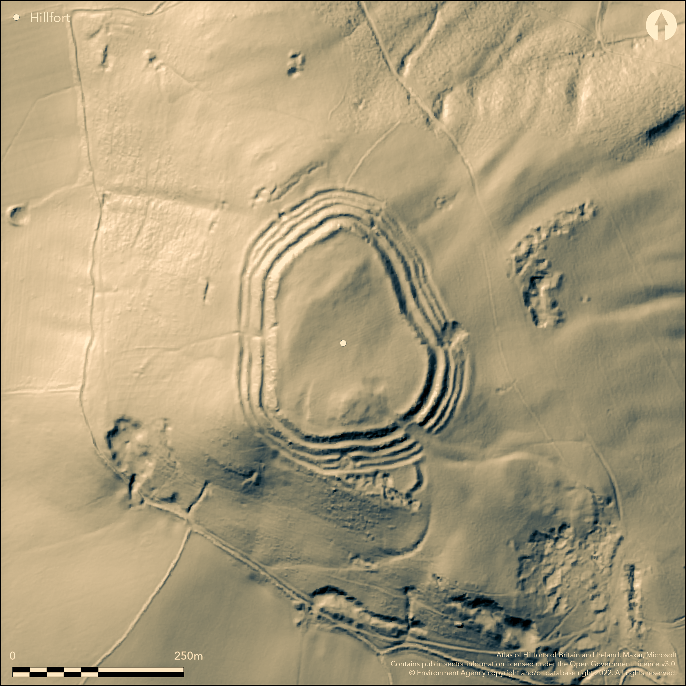
LiDAR 1m DTM Hillshade
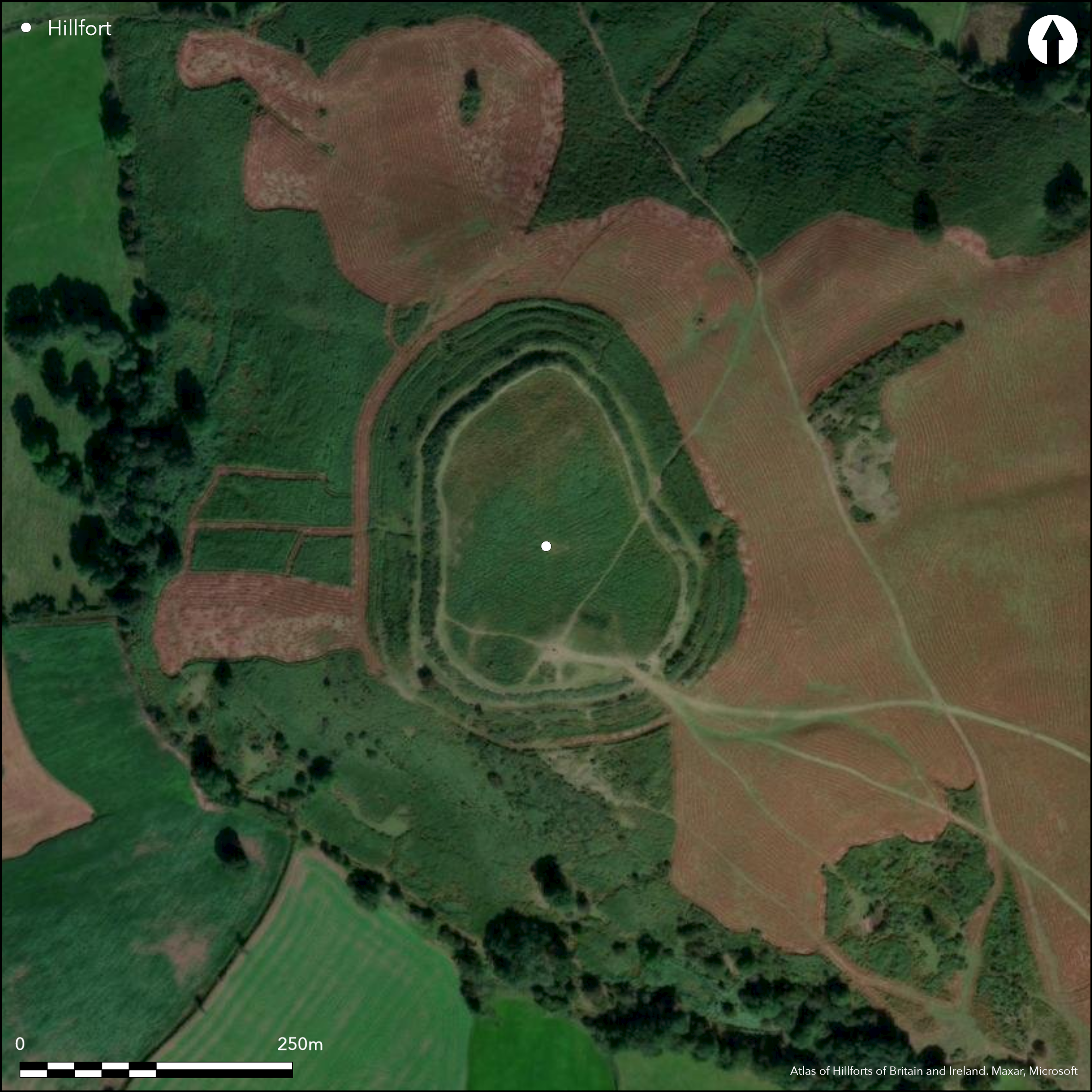
Satellite Imagery
LiDAR 1m DTM Hillshade
Satellite Imagery
Scroll left/right to view further images.
HER: Clwyd Powys 466 (None)
NMR: SO 03 SW (92058)
SM: BR063(POW)
NGR: SO02933037
X: 302930 Y: 230370 (OSGB36)
High, contour hillfort located on an isolated and prominent hill above Brecon and the confluences of the River Usk and the Afon Honddu, the Afon Tarell and Afon Cynrig to S and the Afon Ysgir and Honddu to N. In commanding position the undulating interior rises E-W, with a peak towards the W side. Surrounding slopes falling away steeply in all directions. One of the finest hillforts in Breconshire despite denuded ramparts, quarry damage to outer circuit and past ploughed interior. According to RCAHMW (Coflein 2015) 'Pen-y-crug stands as one of the great achievements in planning and construction of Iron Age Wales'. Site measures internally 182m N-S, by 134m, with interior area 1.86ha. Four ramparts and ditches plus counterscarp follow the contours for most of site with three ramparts and counterscarp on W where slopes steeper. Outer faces of the highest banks 5.2m high in places. Banks of earth and stone, probably by 'downward construction'. Quarry ditch can be seen behind the innermost rampart, which is the most substantial. There is an annexe on the S side. Long inturned entrance on the SE, narrowing to interior. Possible hut site unclear, but bracken encroachment makes interpretation of any structures difficult. On 1st Ed. OS map (1888-89). Few investigations. Undated.
Citizen Science: ✗
Reliability of Data: Confirmed
Reliability of Interpretation: Confirmed
X: -380074 Y: 6793487 (EPSG: 3857)
Longitude: -3.4142623272129304 Latitude: 51.96326814287758 (EPSG:4326)
Country: Wales
Current County or Unitary Authority: Powys
Historic County: Brecknockshire
Current Parish/Community/Council/Townland: Yscir
One of the finest hillforts in Breconshire despite denuded ramparts and ploughed interior.Three quarries damaged outer circuit on N, E and S sides. Interior ploughed in past. De-facto public access and paths crossing site causing erosion.
| Extant | ✓ |
| Cropmark | ✗ |
| Likely Destroyed | ✗ |
Rough upland grazing, bracken and gorse.
| Woodland | ✗ |
| Commercial Forestry Plantation | ✗ |
| Parkland | ✗ |
| Pasture (Grazing) | ✓ |
| Arable | ✗ |
| Scrub/Bracken | ✓ |
| Bare Outcrop | ✗ |
| Heather/Moorland | ✗ |
| Heath | ✗ |
| Built-up | ✗ |
| Coastal Grassland | ✗ |
| Other | ✗ |
High, contour hillfort located on an isolated and prominent hill above Brecon and the confluences of the River Usk and the Afon Honddu, the Afon Tarell and Afon Cynrig to S and the Afon Ysgir and Honddu to N. In commanding position the undulating interior rises E-W, with a peak towards the W side. Surrounding slopes falling away steeply in all directions.
| Contour Fort | ✓ |
| Partial Contour Fort | ✗ |
| Promontory Fort | ✗ |
| Hillslope Fort | ✗ |
| Level Terrain Fort | ✗ |
| Marsh Fort | ✗ |
| Multiple Enclosure Fort | ✗ |
| Hilltop | ✓ |
| Coastal Promontory | ✗ |
| Inland Promontory | ✗ |
| Valley Bottom | ✗ |
| Knoll/Hillock/Outcrop | ✗ |
| Ridge | ✗ |
| Cliff/Plateau-edge/Scarp | ✗ |
| Hillslope | ✗ |
| Lowland | ✗ |
| Spur | ✗ |
Dominant Topographic Feature: Hill top
| North | ✗ |
| Northeast | ✗ |
| East | ✗ |
| Southeast | ✗ |
| South | ✗ |
| Southwest | ✗ |
| West | ✗ |
| Northwest | ✗ |
| Level | ✓ |
Altitude: 331.0m
N/A
None.
Reliability: D - None
| Pre 1200BC | ✗ |
| 1200BC - 800BC | ✗ |
| 800BC - 400BC | ✗ |
| 400BC - AD50 | ✗ |
| AD50 - AD400 | ✗ |
| AD400 - AD 800 | ✗ |
| Post AD800 | ✗ |
| Unknown | ✓ |
| Pre Hillfort: | None |
| Post Hillfort: | None |
On 1st Ed. OS map (1888-89). RCAHMW investigation 1983. CPAT defended enclosures survey 2006-2007.
| Other (1982): | Visit by Hillfort Study Group |
| Other (1983): | RCAHMW investigation. |
| 1st Identified Map Depiction (None): | OS map. |
| Other (None): | CPAT defended enclosures survey. |
Possible hut site unclear, but bracken encroachment makes interpretation of any structures difficult. Quarry ditch can be seen behind the innermost rampart, which is the most substantial.
Stream 0.4km outside fort.
| None | ✓ |
| Spring | ✗ |
| Stream | ✗ |
| Pool | ✗ |
| Flush | ✗ |
| Well | ✗ |
| Other | ✗ |
Possible hut site unclear, but bracken encroachment makes interpretation of any structures difficult. Quarry ditch can be seen behind the innermost rampart, which is the most substantial.
| No Known Features | ✗ |
| Round Stone Structures | ✗ |
| Rectangular Stone Structures | ✗ |
| Curvilinear Platforms | ✓ |
| Other Roundhouse Evidence | ✗ |
| Pits | ✗ |
| Quarry Hollows | ✓ |
| Other | ✗ |
None
| No Known Excavation | ✓ |
| Pits | ✗ |
| Postholes | ✗ |
| Roundhouses | ✗ |
| Rectangular Structures | ✗ |
| Roads/Tracks | ✗ |
| Quarry Hollows | ✗ |
| Other | ✗ |
| Nothing Found | ✗ |
None
| No Known Geophysics | ✓ |
| Pits | ✗ |
| Roundhouses | ✗ |
| Rectangular Structures | ✗ |
| Roads/Tracks | ✗ |
| Quarry Hollows | ✗ |
| Other | ✗ |
| Nothing Found | ✗ |
None
| No Known Finds | ✓ |
| Pottery | ✗ |
| Metal | ✗ |
| Metalworking | ✗ |
| Human Bones | ✗ |
| Animal Bones | ✗ |
| Lithics | ✗ |
| Environmental | ✗ |
| Other | ✗ |
None
| APs Not Checked | ✓ |
| None | ✗ |
| Roundhouses | ✗ |
| Rectangular Structures | ✗ |
| Pits | ✗ |
| Postholes | ✗ |
| Roads/Tracks | ✗ |
| Other | ✗ |
Long inturned entrance on the SE narrowing to interior.
| 2: | Break in ramparts on W. |
| 2: | None |
Guard Chambers: ✗
Chevaux de Frise: ✗
| 1. In-turned (South east): | Long inturned passage entrance. |
| 1. Passage-way/Corridor (South east): | Long inturned passage entrance. |
Four ramparts and ditches plus counterscarp follow the contours for most of site with three ramparts and counterscarp on W where slopes steeper. Outer faces of the highest banks 5.2m high in places. Banks of earth and stone, probably by 'downward construction'.
| Area 1: | 1.86ha. |
| Total: | 1.86ha. |
Total Footprint Area: Noneha.
None
| ✗ | None |
| ✓ | None |
| NE Quadrant: | 4 |
| SE Quadrant: | 4 |
| SW Quadrant: | 3 |
| NW Quadrant: | 3 |
| Total: | 4 |
| Partial Univallate | ✗ |
| Univallate | ✗ |
| Partial Bivallate | ✗ |
| Bivallate | ✗ |
| Partial Multivallate | ✗ |
| Multivallate | ✓ |
| Unknown | ✗ |
| Partial Univallate | ✗ |
| Univallate | ✗ |
| Partial Bivallate | ✗ |
| Bivallate | ✗ |
| Partial Multivallate | ✗ |
| Multivallate | ✗ |
Earth and stone banks. Counterscarp for most of site.
| None | ✗ |
| Earthen Bank | ✓ |
| Stone Wall | ✗ |
| Rubble | ✓ |
| Wall-walk | ✗ |
| Evidence of Timber | ✗ |
| Vitrification | ✗ |
| Other Burning | ✗ |
| Palisade | ✗ |
| Counter Scarp Bank | ✓ |
| Berm | ✗ |
| Unfinished | ✗ |
| Other | ✗ |
None
| None | ✗ |
| Earthen Bank | ✗ |
| Stone Wall | ✗ |
| Murus Duplex | ✗ |
| Timber-framed | ✗ |
| Timber-laced | ✗ |
| Vitrification | ✗ |
| Other Burning | ✗ |
| Palisade | ✗ |
| Counter Scarp Bank | ✗ |
| Berm | ✗ |
| Unfinished | ✗ |
| No Known Excavation | ✓ |
| Other | ✗ |
| ✗ | None |
| ✓ | None |
Number of Ditches: 4
| ✓ | Annexe on S side. |
Burham, H. 1995. A guide to Ancient and Historic Wales - Clwyd and Powys, London: HMSO, 70.
Hogg A.H.A. 1965. Early Iron Age Wales, in Foster, I. LL. and Daniel, S. Prehistoric and Early Wales, London;
Savory, H.N. 1952. List of Hill-forts and other earthworks in Wales, III, Brecknockshire, Bull Board Celtic Stud, 14, 71.
Silvester, B. 2007. The Clwyd-Powys Archaeological Trust. Defended enclosures in Brecknock, CPAT Report No 859, Welshpool: CPAT.
RCAHMW 1986. An inventory of the ancient monuments in Brecknock (Brycheiniog). The Prehistoric and Roman monuments, Vol 1, Part 2, Hill-forts and Roman remains, HF 36, London: HMSO.
Atlas of Hillforts:
Wikidata:
This work is licensed under CC BY-SA 4.0

 and should be cited as:
Lock, Gary and Ralston, Ian. 2024. Atlas of Hillforts of Britain and Ireland. Available at: https://hillforts.arch.ox.ac.uk
Document Version 1.1