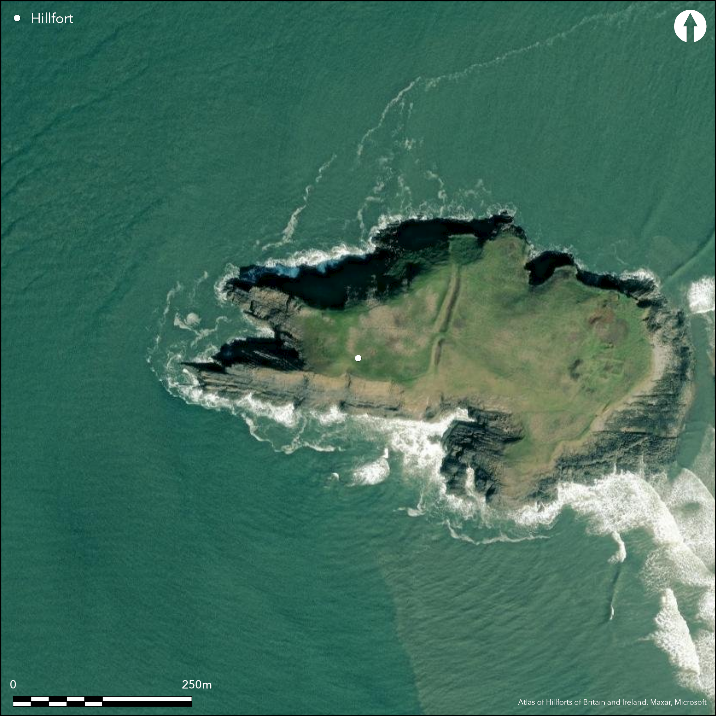
Satellite Imagery
Satellite Imagery
HER: Glamorgan Gwent 00022w (None)
NMR: SS 39 SE (301302)
SM: GM088
NGR: SS39889258
X: 239880 Y: 192580 (OSGB36)
Coastal promontory of irregular shape located on W Gower headland dominating N end of Rhosilli Bay, now cut off at high tide. Rampart and ditch cut across the island at near highest point, enclosing c. third of area, to give enclosure of c. 112m E-W by 60m-200m with internal site area of c. 1.2ha. Rocky surrounding slopes to N, S, E, and W very steep to precipitous. The high rampart, c. 3m-6m high, possible stone face, higher to N side and some 3m above interior, rock-cut ditch c. 2m deep and counterscarp run N-S for c. 100m cuts across higher W part of Burry Holmes island, with ditch using a natural faultline. Simple entrance with causeway across ditch in middle of the bank. Ditch cut across during excavations by D.B. Hague of the ecclesiastical site in 1965, with Romano-British pottery found. Later in 2000-2001 roundhouse, 5.6m in diameter, dated by sherd of 2nd century Samian pottery excavated at W end of island Walker 2001). Early Christian hermitage and a 12th century church at E end of site, whose excavation showed traces of underlying occupation showing as extensive layer of discoloured soil of calcined stone. Cairn on site and evidence of Mesolithic activity. Rugged coastal grassland and bare rock. Coastal erosion. Public access at low tide. On 1st Ed. OS map (1879).
Citizen Science: ✗
Reliability of Data: Confirmed
Reliability of Interpretation: Confirmed
X: -480215 Y: 6729766 (EPSG: 3857)
Longitude: -4.313845954360208 Latitude: 51.60917933711628 (EPSG:4326)
Country: Wales
Current County or Unitary Authority: Swansea
Historic County: Glamorgan
Current Parish/Community/Council/Townland: Llangennith, Llanmadoc and Cheriton
Coastal erosion.
| Extant | ✓ |
| Cropmark | ✗ |
| Likely Destroyed | ✗ |
Rugged coastal grassland and bare rock. Early Christian hermitage and a 12th century church on site.
| Woodland | ✗ |
| Commercial Forestry Plantation | ✗ |
| Parkland | ✗ |
| Pasture (Grazing) | ✗ |
| Arable | ✗ |
| Scrub/Bracken | ✗ |
| Bare Outcrop | ✗ |
| Heather/Moorland | ✗ |
| Heath | ✗ |
| Built-up | ✓ |
| Coastal Grassland | ✓ |
| Other | ✓ |
Coastal promontory on W Gower headland dominating N end of Rhosilli Bay, now cut off at high tide. Rocky surrounding slopes to N, S, E, and W very steep to precipitous.
| Contour Fort | ✗ |
| Partial Contour Fort | ✗ |
| Promontory Fort | ✓ |
| Hillslope Fort | ✗ |
| Level Terrain Fort | ✗ |
| Marsh Fort | ✗ |
| Multiple Enclosure Fort | ✗ |
| Hilltop | ✗ |
| Coastal Promontory | ✓ |
| Inland Promontory | ✗ |
| Valley Bottom | ✗ |
| Knoll/Hillock/Outcrop | ✗ |
| Ridge | ✗ |
| Cliff/Plateau-edge/Scarp | ✗ |
| Hillslope | ✗ |
| Lowland | ✗ |
| Spur | ✗ |
Dominant Topographic Feature: Coastal headland
| North | ✗ |
| Northeast | ✗ |
| East | ✗ |
| Southeast | ✗ |
| South | ✗ |
| Southwest | ✗ |
| West | ✗ |
| Northwest | ✗ |
| Level | ✓ |
Altitude: 30.0m
N/A
Romano-British pottery and Samian sherd of 2nd century AD.
Reliability: C - Low
| Pre 1200BC | ✗ |
| 1200BC - 800BC | ✗ |
| 800BC - 400BC | ✗ |
| 400BC - AD50 | ✗ |
| AD50 - AD400 | ✓ |
| AD400 - AD 800 | ✗ |
| Post AD800 | ✗ |
| Unknown | ✗ |
| Pre Hillfort: | None |
| Post Hillfort: | None |
| Artefactual: | Romano-British pottery and Samian sherd of 2nd century AD. |
On 1st Ed. OS map (1879). Partial excavation of cairn by Lethbridge and David 1924. Ditch excavated by D.B. Hague as part of excavations of the ecclesiastical site in 1965. RCAHMW investigation 1965. Excavation by E.A. Walker 2000-2001. GGAT Prehistoric defended enclosures in Glamorgan survey 2005.
| 1st Identified Map Depiction (1879): | OS map. |
| Excavation (1924): | Lethbridge and David. |
| Excavation (1965): | D.B. Hague |
| Other (1965): | RCAHMW investigation. |
| Other (2005): | GGAT Prehistoric defended enclosures in Glamorgan survey. |
| Excavation (None): | E.A. Walker |
Roundhouse, 5.6m in diameter. Romano-British pottery and Samian sherd.
None
| None | ✓ |
| Spring | ✗ |
| Stream | ✗ |
| Pool | ✗ |
| Flush | ✗ |
| Well | ✗ |
| Other | ✗ |
None
| No Known Features | ✓ |
| Round Stone Structures | ✗ |
| Rectangular Stone Structures | ✗ |
| Curvilinear Platforms | ✗ |
| Other Roundhouse Evidence | ✗ |
| Pits | ✗ |
| Quarry Hollows | ✗ |
| Other | ✗ |
Roundhouse, 5.6m in diameter.
| No Known Excavation | ✗ |
| Pits | ✗ |
| Postholes | ✗ |
| Roundhouses | ✓ |
| Rectangular Structures | ✗ |
| Roads/Tracks | ✗ |
| Quarry Hollows | ✗ |
| Other | ✗ |
| Nothing Found | ✗ |
None
| No Known Geophysics | ✓ |
| Pits | ✗ |
| Roundhouses | ✗ |
| Rectangular Structures | ✗ |
| Roads/Tracks | ✗ |
| Quarry Hollows | ✗ |
| Other | ✗ |
| Nothing Found | ✗ |
Romano-British pottery and Samian sherd.
| No Known Finds | ✗ |
| Pottery | ✓ |
| Metal | ✗ |
| Metalworking | ✗ |
| Human Bones | ✗ |
| Animal Bones | ✗ |
| Lithics | ✗ |
| Environmental | ✗ |
| Other | ✗ |
None
| APs Not Checked | ✓ |
| None | ✗ |
| Roundhouses | ✗ |
| Rectangular Structures | ✗ |
| Pits | ✗ |
| Postholes | ✗ |
| Roads/Tracks | ✗ |
| Other | ✗ |
Simple entrance through middle of rampart on E, with causeway across ditch.
| 1: | None |
| 2: | None |
Guard Chambers: ✗
Chevaux de Frise: ✗
| 1. Simple Gap (East): | Simple gap with causeway. |
The high rampart, c. 3m-6m high, higher to N side and some 3m above interior, possible stone face rock-cut ditch c. 2m deep and counterscarp run N-S for c. 100m cuts across higher W part of Burry Holmes island, with ditch using a natural faultline.
| Area 1: | 1.2ha. |
| Total: | 1.2ha. |
Total Footprint Area: Noneha.
None
| ✗ | None |
| ✗ | None |
| NE Quadrant: | 1 |
| SE Quadrant: | 1 |
| SW Quadrant: | 0 |
| NW Quadrant: | 0 |
| Total: | 1 |
| Partial Univallate | ✓ |
| Univallate | ✗ |
| Partial Bivallate | ✗ |
| Bivallate | ✗ |
| Partial Multivallate | ✗ |
| Multivallate | ✗ |
| Unknown | ✗ |
| Partial Univallate | ✗ |
| Univallate | ✗ |
| Partial Bivallate | ✗ |
| Bivallate | ✗ |
| Partial Multivallate | ✗ |
| Multivallate | ✗ |
Probable stone wall.
| None | ✗ |
| Earthen Bank | ✗ |
| Stone Wall | ✓ |
| Rubble | ✗ |
| Wall-walk | ✗ |
| Evidence of Timber | ✗ |
| Vitrification | ✗ |
| Other Burning | ✗ |
| Palisade | ✗ |
| Counter Scarp Bank | ✓ |
| Berm | ✗ |
| Unfinished | ✗ |
| Other | ✗ |
None
| None | ✓ |
| Earthen Bank | ✗ |
| Stone Wall | ✗ |
| Murus Duplex | ✗ |
| Timber-framed | ✗ |
| Timber-laced | ✗ |
| Vitrification | ✗ |
| Other Burning | ✗ |
| Palisade | ✗ |
| Counter Scarp Bank | ✗ |
| Berm | ✗ |
| Unfinished | ✗ |
| No Known Excavation | ✗ |
| Other | ✗ |
| ✗ | None |
| ✓ | Rock-cut ditch following faultline. |
Number of Ditches: 1
| ✗ | None |
Gerrard, C., Wiggins, H., and Evans, E. 2006. Prehistoric defended enclosures in Glamorgan with recommendations for fieldwork: Year 3 Report, GGAT Report No. 2006/089, Project No. GGAT78, Swansea: GGAT.
Hague, D.B. 1966. Burry Holmes excavation 1965-6, Gower, 17, 34-41.
Hughes, W. 1999. Prehistoric sites of the Gower and West Glamorgan, 103, Little Logaston: Logaston Press, 103.
RCAHMW 1976. An inventory of the ancient monuments in Glamorgan, Vol I: Pre-Norman, Part II The Iron Age and the Roman occupation, No. 612, Cardiff: HMSO.
Savory, H.N. 1949. List of hillforts and other earthworks in Wales, Bull Board Celtic Stud, 13, 157.
Walker, E.A. 2001. Burry Holmes, Gower, Swamsea (SS4001 9247), Morgannwg, 45, 81.
Whittle, E 1992: A guide to ancient and historic Wales - Glamorgan and Gwent, London: HMSO, 49-50.
Atlas of Hillforts:
Wikidata:
This work is licensed under CC BY-SA 4.0

 and should be cited as:
Lock, Gary and Ralston, Ian. 2024. Atlas of Hillforts of Britain and Ireland. Available at: https://hillforts.arch.ox.ac.uk
Document Version 1.1