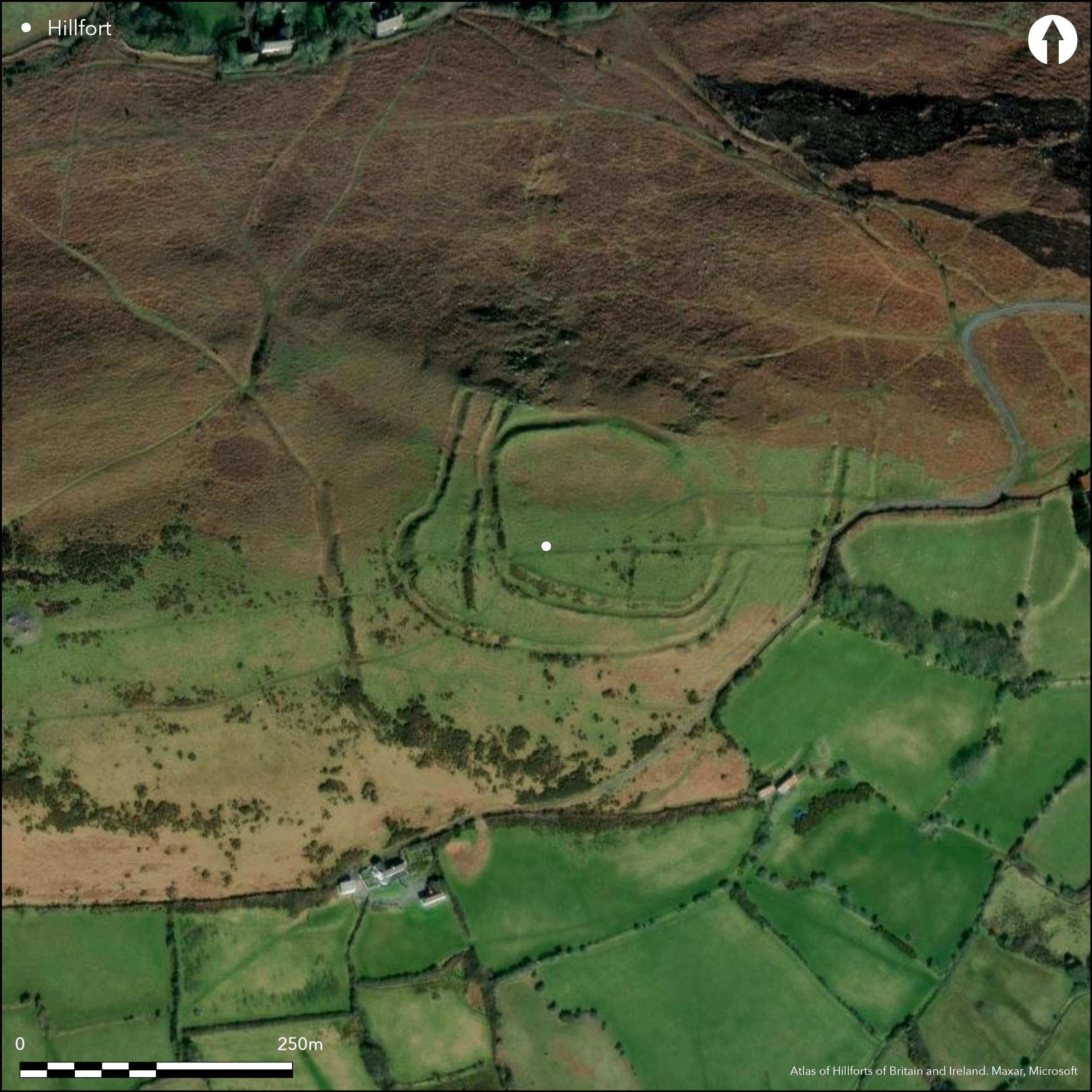
Satellite Imagery
Satellite Imagery
HER: Glamorgan Gwent 00029w (None)
NMR: SS 49 SW 30 (301327)
SM: GM061
NGR: SS44309275
X: 244300 Y: 192750 (OSGB36)
Prominent and complex irregular concentric hillslope enclosure overlooking the coast on the easternmost edge of Llanmadoc Hill and noted for its widely spaced ramparts. N, E surrounding slopes steep, S, W moderate to strong. Its form suggests a series of periods of construction and small excavation by A.G. Davies in 1957 in NW corner of fort confirmed two periods of rampart construction here ,with the inner face of rampart having stone revetment. Main enclosure, measuring 92m by 120m with 0.9ha-1ha total internal area, bounded by massive bank with external ditch, apart from on N, and counterscarp on S. Series of discontinuous outer banks and ditch on S, E and W add to complexity. Sub-rectangular enclosure within the main enclosure, of 48m by 26m and area c. 0.12ha, is set against the rampart on the SE, just inside the entrance. This may be an earlier enclosure or possible animal pound. There is also a possible circular structure adjoining. Simple gap, but wide (12m), entrance on E side reached through low banks through a series of outer banks or outworks and the main outer rampart - the so-called 'Processional Way'. Rough upland pasture. Fair condition. On 1st Ed. OS map (1879). Undated.
Citizen Science: ✗
Reliability of Data: Confirmed
Reliability of Interpretation: Confirmed
X: -473124 Y: 6730262 (EPSG: 3857)
Longitude: -4.250142160447147 Latitude: 51.61194700723148 (EPSG:4326)
Country: Wales
Current County or Unitary Authority: Swansea
Historic County: Glamorgan
Current Parish/Community/Council/Townland: Llangennith, Llanmadoc and Cheriton
Fair condition.
| Extant | ✓ |
| Cropmark | ✗ |
| Likely Destroyed | ✗ |
Rough upland pasture.
| Woodland | ✗ |
| Commercial Forestry Plantation | ✗ |
| Parkland | ✗ |
| Pasture (Grazing) | ✓ |
| Arable | ✗ |
| Scrub/Bracken | ✗ |
| Bare Outcrop | ✗ |
| Heather/Moorland | ✗ |
| Heath | ✗ |
| Built-up | ✗ |
| Coastal Grassland | ✗ |
| Other | ✗ |
Prominent and complex irregular concentric hillslope enclosure overlooking the coast on the easternmost edge of Llanmadoc Hill and noted for its widely spaced ramparts. N, E surrounding slopes steep, S, W moderate to strong.
| Contour Fort | ✗ |
| Partial Contour Fort | ✗ |
| Promontory Fort | ✗ |
| Hillslope Fort | ✓ |
| Level Terrain Fort | ✗ |
| Marsh Fort | ✗ |
| Multiple Enclosure Fort | ✗ |
| Hilltop | ✗ |
| Coastal Promontory | ✗ |
| Inland Promontory | ✗ |
| Valley Bottom | ✗ |
| Knoll/Hillock/Outcrop | ✗ |
| Ridge | ✗ |
| Cliff/Plateau-edge/Scarp | ✗ |
| Hillslope | ✓ |
| Lowland | ✗ |
| Spur | ✗ |
Dominant Topographic Feature: Hillslope
| North | ✗ |
| Northeast | ✓ |
| East | ✗ |
| Southeast | ✗ |
| South | ✗ |
| Southwest | ✗ |
| West | ✗ |
| Northwest | ✗ |
| Level | ✗ |
Altitude: 159.0m
N/A
None
Reliability: D - None
| Pre 1200BC | ✗ |
| 1200BC - 800BC | ✗ |
| 800BC - 400BC | ✗ |
| 400BC - AD50 | ✗ |
| AD50 - AD400 | ✗ |
| AD400 - AD 800 | ✗ |
| Post AD800 | ✗ |
| Unknown | ✓ |
| Pre Hillfort: | None |
| Post Hillfort: | None |
On 1st Ed. OS map (1879). Small excavation by A.G. Davies in 1957 - no details. RCAHMW investigation 1962. National Trust survey 1987. GGAT Prehistoric defended enclosures in Glamorgan survey 2005.
| 1st Identified Map Depiction (1879): | OS map |
| Excavation (1957): | A.G. Davies - no details. |
| Other (1962): | RCAHMW investigation. |
| Other (1986): | Visited by Hillfort Study Group |
| Other (2005): | GGAT Prehistoric defended enclosures in Glamorgan survey. |
| Other (None): | National Trust surveys. |
Sub-rectangular enclosure within the main enclosure of 48m by 26m is set against the rampart on the SE, just inside the entrance. This may be an earlier enclosure or possible animal pound. There is also a possible circular structure adjoining.
None
| None | ✓ |
| Spring | ✗ |
| Stream | ✗ |
| Pool | ✗ |
| Flush | ✗ |
| Well | ✗ |
| Other | ✗ |
Sub-rectangular enclosure within the main enclosure of 48m by 26m is set against the rampart on the SE, just inside the entrance. This may be an earlier enclosure or possible animal pound. There is also a possible circular structure adjoining.
| No Known Features | ✗ |
| Round Stone Structures | ✗ |
| Rectangular Stone Structures | ✗ |
| Curvilinear Platforms | ✓ |
| Other Roundhouse Evidence | ✗ |
| Pits | ✗ |
| Quarry Hollows | ✗ |
| Other | ✓ |
None
| No Known Excavation | ✓ |
| Pits | ✗ |
| Postholes | ✗ |
| Roundhouses | ✗ |
| Rectangular Structures | ✗ |
| Roads/Tracks | ✗ |
| Quarry Hollows | ✗ |
| Other | ✗ |
| Nothing Found | ✗ |
None
| No Known Geophysics | ✓ |
| Pits | ✗ |
| Roundhouses | ✗ |
| Rectangular Structures | ✗ |
| Roads/Tracks | ✗ |
| Quarry Hollows | ✗ |
| Other | ✗ |
| Nothing Found | ✗ |
None
| No Known Finds | ✓ |
| Pottery | ✗ |
| Metal | ✗ |
| Metalworking | ✗ |
| Human Bones | ✗ |
| Animal Bones | ✗ |
| Lithics | ✗ |
| Environmental | ✗ |
| Other | ✗ |
None
| APs Not Checked | ✓ |
| None | ✗ |
| Roundhouses | ✗ |
| Rectangular Structures | ✗ |
| Pits | ✗ |
| Postholes | ✗ |
| Roads/Tracks | ✗ |
| Other | ✗ |
Simple gap, but wide (12m), entrance on E side reached through low banks through a series of outer banks or outworks and the main outer rampart - the so-called 'Processional Way'.
| 1: | None |
| 2: | None |
Guard Chambers: ✗
Chevaux de Frise: ✗
| 1. Outworks (East): | Reached through low banks through a series of outer banks or outworks and the main outer rampart - the so-called 'Processional Way'. |
| 1. Simple Gap (East): | 12m wide gap. |
Main enclosure, measuring 92m by 120m with 0.9-1ha total internal area, bounded by massive bank with external ditch, apart from on N, and counterscarp on S. Series of discontinuous outer banks and ditch on S, E and W add to complexity. Sub-rectangular enclosure within the main enclosure, of 48m by 26m and area c. 0.12ha, is set against the rampart on the SE, just inside the entrance.
| Area 1: | 0.12ha. |
| Area 2: | 0.9ha. |
| Total: | 0.9ha. |
Total Footprint Area: Noneha.
None
| ✓ | Its form suggests a series of periods of construction and small excavation by A.G. Davies in 1957 in NW corner of fort confirmed two periods of rampart construction here. |
| ✓ | Outer banks included in quadrant analysis. |
| NE Quadrant: | 4 |
| SE Quadrant: | 3 |
| SW Quadrant: | 4 |
| NW Quadrant: | 2 |
| Total: | 4 |
| Partial Univallate | ✗ |
| Univallate | ✗ |
| Partial Bivallate | ✓ |
| Bivallate | ✗ |
| Partial Multivallate | ✓ |
| Multivallate | ✗ |
| Unknown | ✗ |
| Partial Univallate | ✗ |
| Univallate | ✓ |
| Partial Bivallate | ✗ |
| Bivallate | ✗ |
| Partial Multivallate | ✗ |
| Multivallate | ✗ |
Counterscarp on S.
| None | ✗ |
| Earthen Bank | ✓ |
| Stone Wall | ✗ |
| Rubble | ✗ |
| Wall-walk | ✗ |
| Evidence of Timber | ✗ |
| Vitrification | ✗ |
| Other Burning | ✗ |
| Palisade | ✗ |
| Counter Scarp Bank | ✓ |
| Berm | ✗ |
| Unfinished | ✗ |
| Other | ✗ |
Excavation in NW corner of fort confirmed two periods of rampart construction here, with the inner face of rampart having stone revetment.
| None | ✗ |
| Earthen Bank | ✗ |
| Stone Wall | ✓ |
| Murus Duplex | ✗ |
| Timber-framed | ✗ |
| Timber-laced | ✗ |
| Vitrification | ✗ |
| Other Burning | ✗ |
| Palisade | ✗ |
| Counter Scarp Bank | ✗ |
| Berm | ✗ |
| Unfinished | ✗ |
| No Known Excavation | ✗ |
| Other | ✗ |
| ✗ | None |
| ✓ | None |
Number of Ditches: 3
| ✗ | None |
Dillon E. and Latham J. 1987. The North Gower Properties, The National Trust Archaeological Survey, London:National Trust.
Fox, A. 1952. Hill-Slope Forts and Related Earthworks in South-West England and South Wales, Arch J, 109 (1952), 1-22.
Gerrard, C., Wiggins, H., and Evans, E. 2006. Prehistoric defended enclosures in Glamorgan with recommendations for fieldwork: Year 3 Report, GGAT Report No 2006/089, Project No GGAT78, Swansea: GGAT.
Poucher, P. 2003. The National Trust Archaeological Survey, North Gower Properties: Whiteford Burrows, Llanrhidian Marsh, The Bulwark, Ryer's Down & Welsh Moor. London: National Trust.
RCAHMW 1976. An inventory of the ancient monuments in Glamorgan, 1.2, Pre-Norman, Parts I-III, No. 689, Cardiff: HMSO.
Savory, H.N. 1949. List of hill-forts and other earthworks in Wales, Bull Board Celtic Stud, 13, 158;
Whittle, E. 1992. A guide to ancient and historic Wales - Glamorgan and Gwent, London: HMSO, 36.
Atlas of Hillforts:
Wikidata:
This work is licensed under CC BY-SA 4.0

 and should be cited as:
Lock, Gary and Ralston, Ian. 2024. Atlas of Hillforts of Britain and Ireland. Available at: https://hillforts.arch.ox.ac.uk
Document Version 1.1