LiDAR 1m DTM Hillshade
Satellite Imagery
LiDAR 1m DTM Hillshade
Satellite Imagery
Scroll left/right to view further images.
HER: Glamorgan Gwent 00451w (None)
NMR: SS 69 SE (None)
SM: GM315
NGR: SS67379472
X: 267370 Y: 194720 (OSGB36)
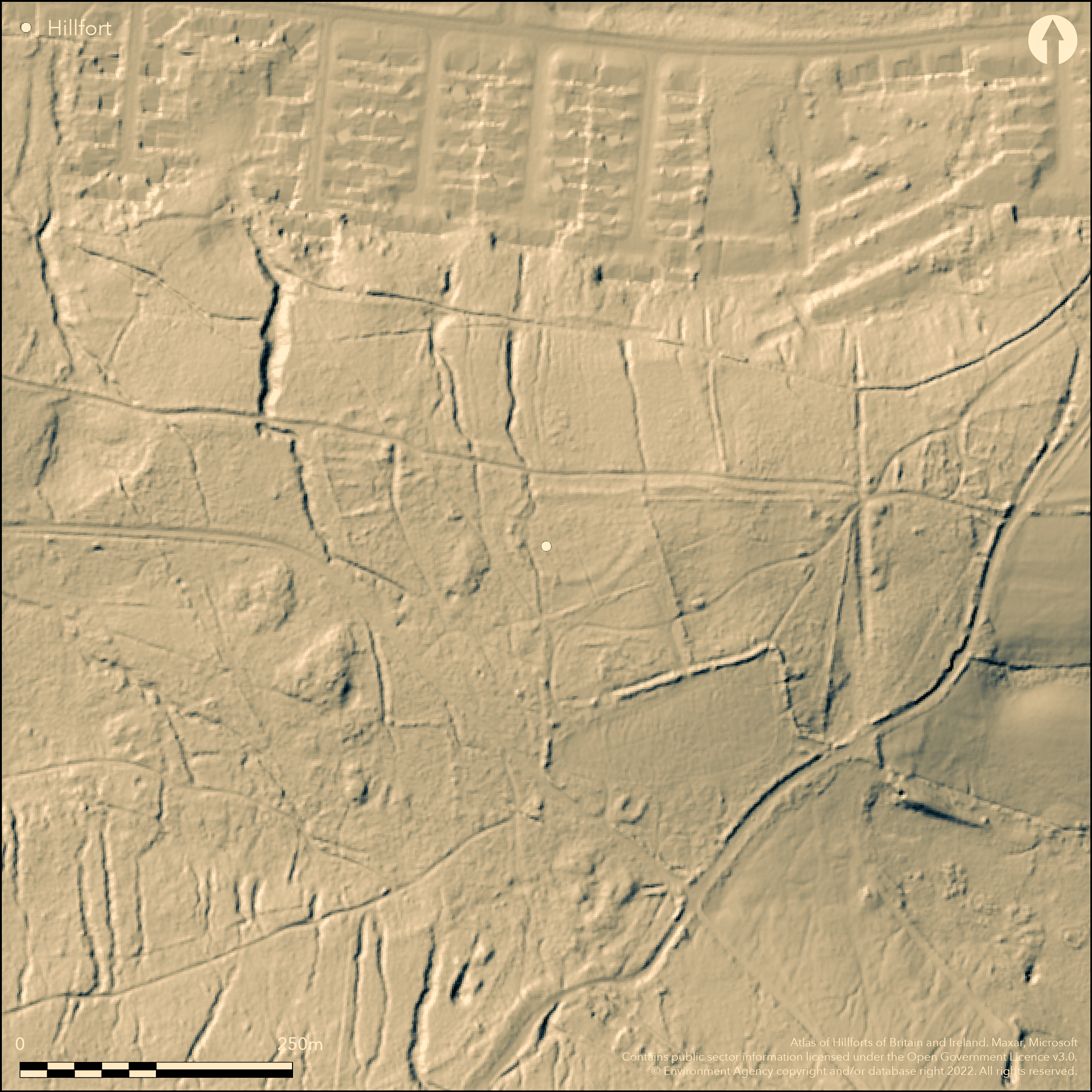
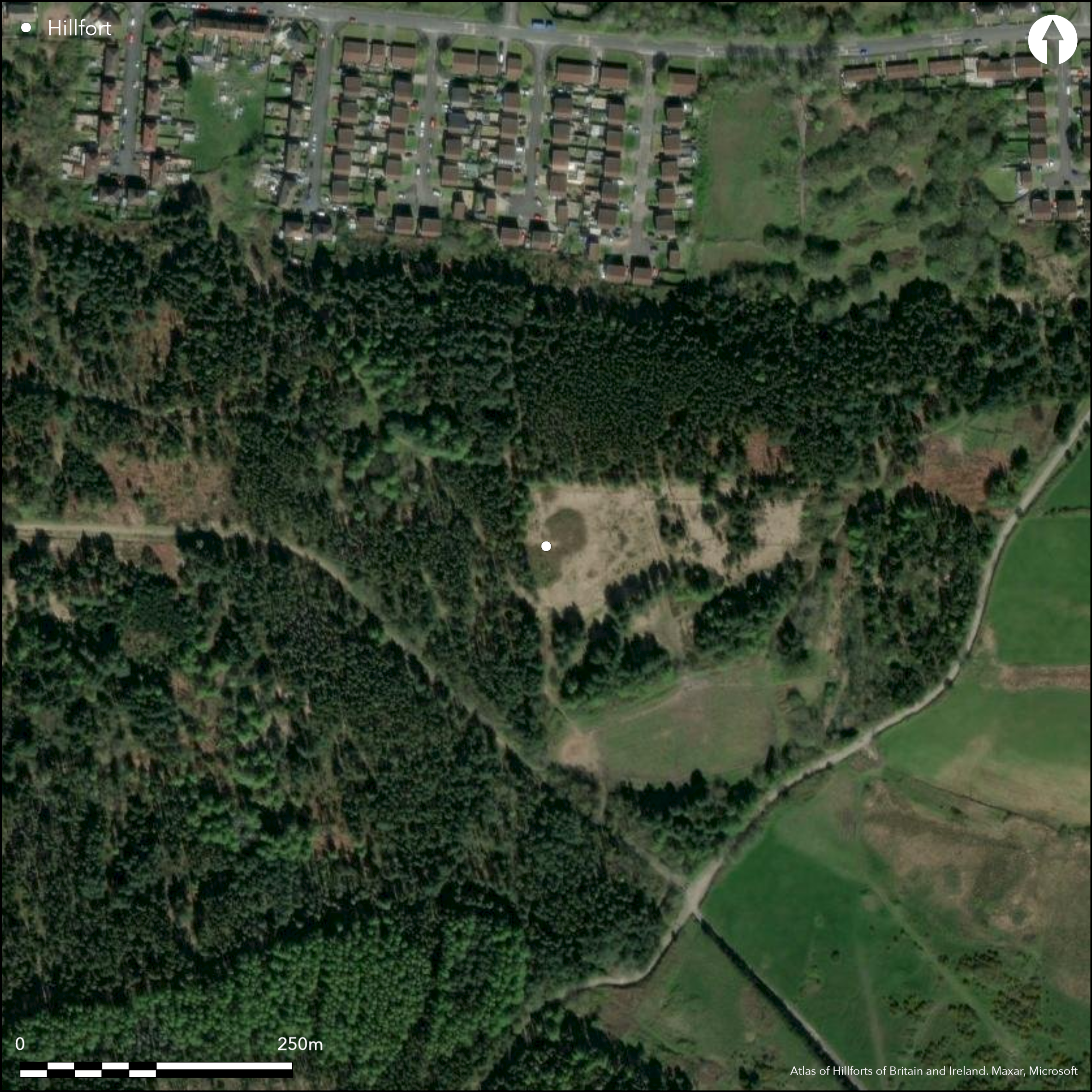
Small oval hillslope fort located on N side of Kilvey Hill, Swansea, near to Carn Nicolas hillfort (Atlas No 1653) (0.35km) and overlooking River Tawe. Moderate to strong surrounding slopes. Measures c. 63m E-W by 50m on almost level ground with general fall to N with internal area 0.25ha. At present defined by low bank and shallow ditch, best on W where bank only 0.5m high and only 7m overall. On N field bank confuses interpretation, and bank could have been obliterated here. On S bank very faint and spread and on E gone. However, excavation by B. Morris for Gower Society and Royal Institution of South Wales (1960s, no reference) suggests two banks with medial flat-bottomed ditch. No entrance defined. Sherd of mid second century AD Samian ware beneath inner bank.
Citizen Science: ✗
Reliability of Data: Confirmed
Reliability of Interpretation: Confirmed
X: -436140 Y: 6734497 (EPSG: 3857)
Longitude: -3.917913784836986 Latitude: 51.635562054867435 (EPSG:4326)
Country: Wales
Current County or Unitary Authority: Swansea
Historic County: Glamorgan
Current Parish/Community/Council/Townland: St Thomas
Damaged and much lost.
| Extant | ✓ |
| Cropmark | ✗ |
| Likely Destroyed | ✓ |
Rough grass and trees.
| Woodland | ✓ |
| Commercial Forestry Plantation | ✗ |
| Parkland | ✗ |
| Pasture (Grazing) | ✓ |
| Arable | ✗ |
| Scrub/Bracken | ✗ |
| Bare Outcrop | ✗ |
| Heather/Moorland | ✗ |
| Heath | ✗ |
| Built-up | ✗ |
| Coastal Grassland | ✗ |
| Other | ✗ |
Small oval hillslope fort located on N side of Kilvey Hill, Swansea, near to Carn Nicolas hilfort (0.35km) and overlooking River Tawe. Moderate to strong surrounding slopes.
| Contour Fort | ✗ |
| Partial Contour Fort | ✗ |
| Promontory Fort | ✗ |
| Hillslope Fort | ✓ |
| Level Terrain Fort | ✗ |
| Marsh Fort | ✗ |
| Multiple Enclosure Fort | ✗ |
| Hilltop | ✗ |
| Coastal Promontory | ✗ |
| Inland Promontory | ✗ |
| Valley Bottom | ✗ |
| Knoll/Hillock/Outcrop | ✗ |
| Ridge | ✗ |
| Cliff/Plateau-edge/Scarp | ✗ |
| Hillslope | ✓ |
| Lowland | ✗ |
| Spur | ✗ |
Dominant Topographic Feature: Hillslope
| North | ✓ |
| Northeast | ✗ |
| East | ✗ |
| Southeast | ✗ |
| South | ✗ |
| Southwest | ✗ |
| West | ✗ |
| Northwest | ✗ |
| Level | ✗ |
Altitude: 107.0m
N/A
Sherd of mid second century AD Samian ware beneath inner bank.
Reliability: C - Low
| Pre 1200BC | ✗ |
| 1200BC - 800BC | ✗ |
| 800BC - 400BC | ✗ |
| 400BC - AD50 | ✗ |
| AD50 - AD400 | ✓ |
| AD400 - AD 800 | ✗ |
| Post AD800 | ✗ |
| Unknown | ✗ |
| Pre Hillfort: | None |
| Post Hillfort: | None |
| Artefactual: | Sherd of Samian ware. |
RCAHMW investigation 1961. Excavation by B. Morris for Gower Society and Royal Institution of South Wales 1960's. GGAT Prehistoric defended enclosures in Glamorgan survey 2005.
| Other (1961): | RCAHMW investigation. |
| Other (2005): | GGAT Prehistoric defended enclosures in Glamorgan survey. |
| Excavation (None): | B. Morris for Gower Society and Royal Institution of South Wales - no details. |
Sherd of mid second century AD Samian ware beneath inner bank.
Stream 0.7km outside fort.
| None | ✓ |
| Spring | ✗ |
| Stream | ✗ |
| Pool | ✗ |
| Flush | ✗ |
| Well | ✗ |
| Other | ✗ |
None
| No Known Features | ✓ |
| Round Stone Structures | ✗ |
| Rectangular Stone Structures | ✗ |
| Curvilinear Platforms | ✗ |
| Other Roundhouse Evidence | ✗ |
| Pits | ✗ |
| Quarry Hollows | ✗ |
| Other | ✗ |
None
| No Known Excavation | ✗ |
| Pits | ✗ |
| Postholes | ✗ |
| Roundhouses | ✗ |
| Rectangular Structures | ✗ |
| Roads/Tracks | ✗ |
| Quarry Hollows | ✗ |
| Other | ✗ |
| Nothing Found | ✓ |
None
| No Known Geophysics | ✓ |
| Pits | ✗ |
| Roundhouses | ✗ |
| Rectangular Structures | ✗ |
| Roads/Tracks | ✗ |
| Quarry Hollows | ✗ |
| Other | ✗ |
| Nothing Found | ✗ |
Sherd of mid second century AD Samian ware beneath inner bank.
| No Known Finds | ✗ |
| Pottery | ✓ |
| Metal | ✗ |
| Metalworking | ✗ |
| Human Bones | ✗ |
| Animal Bones | ✗ |
| Lithics | ✗ |
| Environmental | ✗ |
| Other | ✗ |
None
| APs Not Checked | ✓ |
| None | ✗ |
| Roundhouses | ✗ |
| Rectangular Structures | ✗ |
| Pits | ✗ |
| Postholes | ✗ |
| Roads/Tracks | ✗ |
| Other | ✗ |
No entrance defined.
| 0: | None |
| 2: | None |
Guard Chambers: ✗
Chevaux de Frise: ✗
At present defined by low bank and shallow ditch, best on W where to bank only 0.5m high and only 7m overall. On N field bank confuses interpretation, and bank could have been obliterated here. On S bank very faint and spread and on E gone. However,excavation by B. Morris for Gower Society and Royal Institution of South Wales suggests two banks with medial flat-bottomed ditch.
| Area 1: | 0.25ha. |
| Total: | 0.25ha. |
Total Footprint Area: Noneha.
None
| ✗ | None |
| ✗ | Excavation suggests two banks with medial flat-bottomed ditch. |
| NE Quadrant: | 0 |
| SE Quadrant: | 0 |
| SW Quadrant: | 1 |
| NW Quadrant: | 0 |
| Total: | 1 |
| Partial Univallate | ✓ |
| Univallate | ✗ |
| Partial Bivallate | ✗ |
| Bivallate | ✗ |
| Partial Multivallate | ✗ |
| Multivallate | ✗ |
| Unknown | ✗ |
| Partial Univallate | ✗ |
| Univallate | ✗ |
| Partial Bivallate | ✗ |
| Bivallate | ✗ |
| Partial Multivallate | ✗ |
| Multivallate | ✗ |
None
| None | ✗ |
| Earthen Bank | ✓ |
| Stone Wall | ✗ |
| Rubble | ✗ |
| Wall-walk | ✗ |
| Evidence of Timber | ✗ |
| Vitrification | ✗ |
| Other Burning | ✗ |
| Palisade | ✗ |
| Counter Scarp Bank | ✗ |
| Berm | ✗ |
| Unfinished | ✗ |
| Other | ✗ |
None
| None | ✓ |
| Earthen Bank | ✗ |
| Stone Wall | ✗ |
| Murus Duplex | ✗ |
| Timber-framed | ✗ |
| Timber-laced | ✗ |
| Vitrification | ✗ |
| Other Burning | ✗ |
| Palisade | ✗ |
| Counter Scarp Bank | ✗ |
| Berm | ✗ |
| Unfinished | ✗ |
| No Known Excavation | ✗ |
| Other | ✗ |
| ✗ | None |
| ✓ | None |
Number of Ditches: 1
| ✗ | None |
Gerrard, C., Wiggins, H., and Evans, E. 2006. Prehistoric defended enclosures in Glamorgan with recommendations for fieldwork: Year 3 Report, GGAT Report No. 2006/089, Project No. GGAT78, Swansea: GGAT.
RCAHMW 1976. An inventory of the ancient monuments in Glamorgan, Vol I: Pre-Norman, Part II The Iron Age and the Roman occupation, No. 650, Cardiff: HMSO.
Atlas of Hillforts:
Wikidata:
This work is licensed under CC BY-SA 4.0![]()
![]()
![]() and should be cited as:
and should be cited as:
Lock, Gary and Ralston, Ian. 2024. Atlas of Hillforts of Britain and Ireland. Available at: https://hillforts.arch.ox.ac.uk
Document Version 1.1