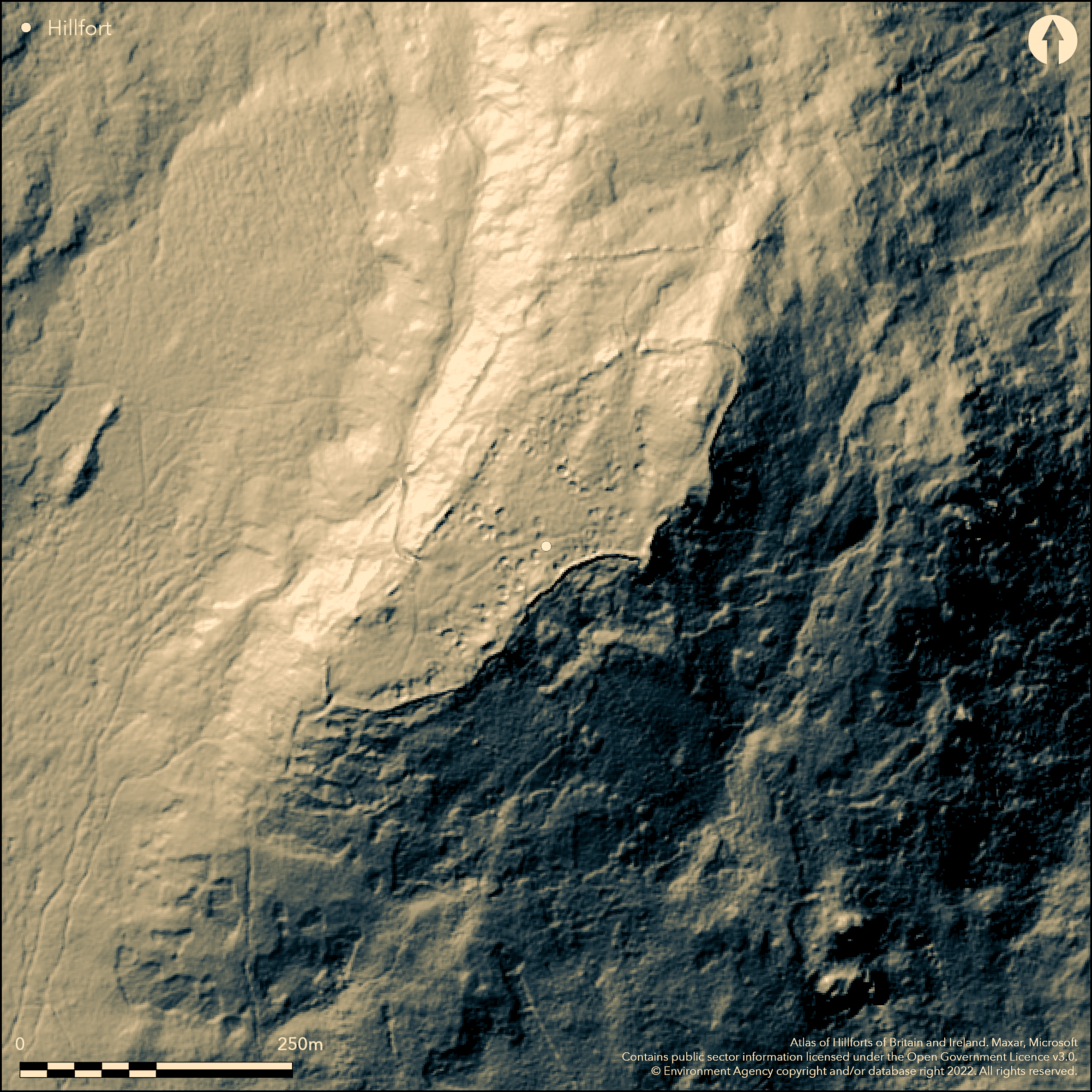
LiDAR 1m DTM Hillshade
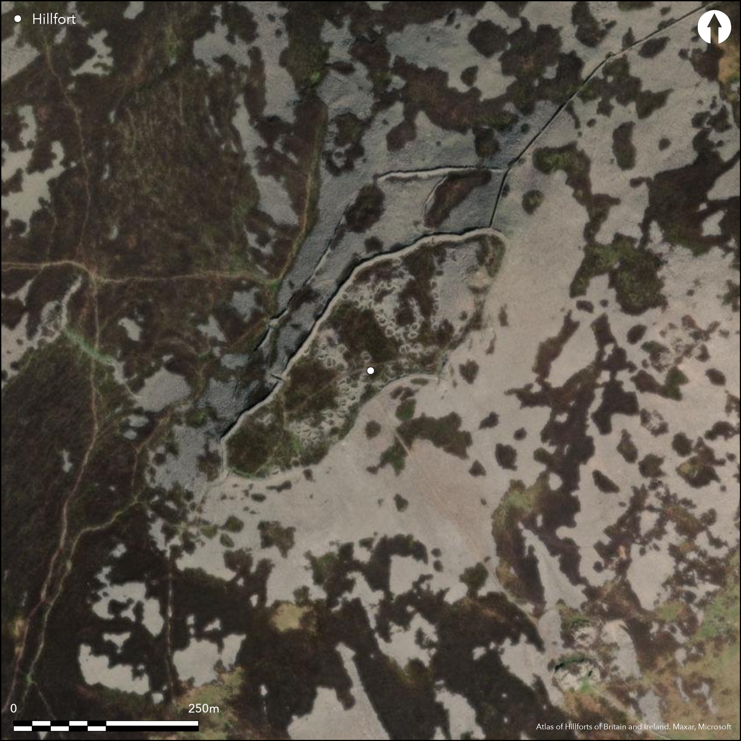
Satellite Imagery
LiDAR 1m DTM Hillshade
Satellite Imagery
Scroll left/right to view further images.
HER: Gwynedd 613 (None)
NMR: SH 34 SE 2 (95292)
SM: CN028
NGR: SH37354465
X: 237350 Y: 344650 (OSGB36)
High and outstanding, stone-built, contour hillfort located on E of three peaks of Yr Eifl on the Ll_n Peninsula. Surrounding scree-covered slopes moderate to strong to N along ridge, E, S and W very steep to precipitous. Measures 316.5m long by 113m wide with internal area 2ha. Impressive surrounding stone main rampart, using rock outcrops, intact, 2.3m-3m wide with surmounting walkway. No ditch. Best on N and W to 4.3m high on outer face and 2m on inner. Interior 150 huts built into scree with 1m+ walls in places (reconstructed in part), round, rectangular and D-shaped, jumbled together. Further groups of irregular enclosures outside main walls to N, where slopes gentler, and W,continuing around S end of site. Possible Bronze Age cairn at highest E end, c. 15m diameter, built of natural curved slabs laid to slope slightly downwards towards centre. Two main entrances with three postern gates. Main entrance on W, that on N threaded through additional walls. Posterns on N side, one with repaired lintel. Excavations 1903 when 32 huts investigated by Rev Baring-Gould and R. Burnard. In 1906 H. Hughes produced first accurate plan, excavating another 32 huts and SW entrance. W.J. Hemp, G.Bersu and C.A. Gresham carried out further excavations 1939 and selective excavation in 1956 by A.H.A. Hogg produced Roman pottery, suggesting occupation into 4th century AD from late Iron Age. Subject of major conservation project by Cyngor Dosbarth Dwyfor, Gwynedd County Council, Gwynedd Archaeological Trust and CADW in response to continued visitor pressure. Good condition and walls stabilised and consolidated together with many huts. Moorland and rough grass with much bare rock. On 1st Ed. OS map (1889).
Citizen Science: ✗
Reliability of Data: Confirmed
Reliability of Interpretation: Confirmed
X: -492458 Y: 6978272 (EPSG: 3857)
Longitude: -4.423822642294687 Latitude: 52.97444193794017 (EPSG:4326)
Country: Wales
Current County or Unitary Authority: Gwynedd
Historic County: Caernarfonshire
Current Parish/Community/Council/Townland: Llanaelhaearn
Good condition now after years of deterioration, with ramparts and huts conserved, stabilised and reconsolidated as part of major conservation project in response to visitor pressure.
| Extant | ✓ |
| Cropmark | ✗ |
| Likely Destroyed | ✗ |
Moorland and rough grass with much bare rock.
| Woodland | ✗ |
| Commercial Forestry Plantation | ✗ |
| Parkland | ✗ |
| Pasture (Grazing) | ✗ |
| Arable | ✗ |
| Scrub/Bracken | ✗ |
| Bare Outcrop | ✗ |
| Heather/Moorland | ✓ |
| Heath | ✗ |
| Built-up | ✗ |
| Coastal Grassland | ✗ |
| Other | ✗ |
High and outstanding, stone-built, contour hillfort located on E of three peaks of Yr Eifl on the Ll_n Peninsula. Surrounding scree-covered slopes moderate to strong to N along ridge, E, S and W very steep to precipitous.
| Contour Fort | ✓ |
| Partial Contour Fort | ✗ |
| Promontory Fort | ✗ |
| Hillslope Fort | ✗ |
| Level Terrain Fort | ✗ |
| Marsh Fort | ✗ |
| Multiple Enclosure Fort | ✗ |
| Hilltop | ✓ |
| Coastal Promontory | ✗ |
| Inland Promontory | ✗ |
| Valley Bottom | ✗ |
| Knoll/Hillock/Outcrop | ✗ |
| Ridge | ✗ |
| Cliff/Plateau-edge/Scarp | ✗ |
| Hillslope | ✗ |
| Lowland | ✗ |
| Spur | ✗ |
Dominant Topographic Feature: Hill top
| North | ✗ |
| Northeast | ✗ |
| East | ✗ |
| Southeast | ✗ |
| South | ✗ |
| Southwest | ✗ |
| West | ✗ |
| Northwest | ✗ |
| Level | ✓ |
Altitude: 485.0m
N/A
Late Iron Age to 4th century AD.
Reliability: C - Low
| Pre 1200BC | ✗ |
| 1200BC - 800BC | ✗ |
| 800BC - 400BC | ✗ |
| 400BC - AD50 | ✓ |
| AD50 - AD400 | ✓ |
| AD400 - AD 800 | ✗ |
| Post AD800 | ✗ |
| Unknown | ✗ |
| Pre Hillfort: | None |
| Post Hillfort: | None |
| Artefactual: | Iron Age brooch. |
| Artefactual: | Roman pottery. |
On 1st Ed. OS map (1889). Excavations in 1903 when 32 of the huts were investigated by Rev Baring-Gould and R. Burnard. In 1906 H. Hughes produced the first accurate plan of the site and excavated another 32 huts and the SW entrance. W.J. Hemp, G.Bersu and C.A. Gresham carried out further excavations in 1939 and selective excavation in 1956 by A.H.A. Hogg produced Roman pottery, suggesting occupation into the 4th century. Ordnance Survey bersvations 1975, 1976. Major conservation project by Cyngor Dosbarth Dwyfor, Gwynedd County Council, Gwynedd Archaeological Trust and CADW 1994-2002. GAT prehistoric defended enclosures survey 2005-2006.
| 1st Identified Map Depiction (1889): | OS map. |
| Excavation (1903): | Rev Baring-Gould and R. Burnard. |
| Excavation (1906): | H. H. Hughes. |
| Excavation (1939): | W.J. Hemp, G.Bersu and C.A. Gresham |
| Excavation (1956): | A.H.A. Hogg |
| Other (1967): | Visit by the Hillfort Study Group |
| Other (2005): | Visited by Hillfort Study Group |
| Other (None): | Ordnance Survey observations. |
| Other (None): | Conservation project by Cyngor Dosbarth Dwyfor, Gwynedd County Council, Gwynedd Archaeological Trust and CADW. |
| Other (None): | GAT prehistoric defended enclosures survey. |
Interior has 150 huts built into the scree with 1m+ walls in places (reconstructed in part), round, rectangular and D-shaped, jumbled together. Roman pottery. Iron Age brooch.
Stream 0.8km outside fort.
| None | ✓ |
| Spring | ✗ |
| Stream | ✗ |
| Pool | ✗ |
| Flush | ✗ |
| Well | ✗ |
| Other | ✗ |
Interior has 150 huts built into the scree with 1m+ walls in places (reconstructed in part), round, rectangular and D-shaped, jumbled together.
| No Known Features | ✗ |
| Round Stone Structures | ✓ |
| Rectangular Stone Structures | ✓ |
| Curvilinear Platforms | ✓ |
| Other Roundhouse Evidence | ✓ |
| Pits | ✗ |
| Quarry Hollows | ✗ |
| Other | ✓ |
Interior has 150 huts built into the scree with 1m+ walls in places (reconstructed in part), round, rectangular and D-shaped, jumbled together.
| No Known Excavation | ✗ |
| Pits | ✗ |
| Postholes | ✗ |
| Roundhouses | ✓ |
| Rectangular Structures | ✓ |
| Roads/Tracks | ✗ |
| Quarry Hollows | ✗ |
| Other | ✓ |
| Nothing Found | ✗ |
None
| No Known Geophysics | ✓ |
| Pits | ✗ |
| Roundhouses | ✗ |
| Rectangular Structures | ✗ |
| Roads/Tracks | ✗ |
| Quarry Hollows | ✗ |
| Other | ✗ |
| Nothing Found | ✗ |
Roman pottery. Iron Age brooch.
| No Known Finds | ✗ |
| Pottery | ✓ |
| Metal | ✓ |
| Metalworking | ✗ |
| Human Bones | ✗ |
| Animal Bones | ✗ |
| Lithics | ✗ |
| Environmental | ✗ |
| Other | ✗ |
None
| APs Not Checked | ✓ |
| None | ✗ |
| Roundhouses | ✗ |
| Rectangular Structures | ✗ |
| Pits | ✗ |
| Postholes | ✗ |
| Roads/Tracks | ✗ |
| Other | ✗ |
Two main entrances with three posterns. Main entrance on SW, that on NW threaded through additional walls. Posterns on E, W and N side, latter with corresponding gap through outer wall. SW gateway is approached by cleared track winding though the extramural enclosures. The NW entrance is approached by a well-marked cleared and terraced trackway which starts 150m outside the outer wall.
| 5: | None |
| 2: | None |
Guard Chambers: ✗
Chevaux de Frise: ✗
| 1. Simple Gap (North west): | Cleared and terraced trackway approach. |
| 2. Over-lapping (South west): | SW gateway is approached by cleared track winding though the extramural enclosures. |
| 2. Simple Gap (None): | SW gateway is approached by cleared track winding though the extramural enclosures. |
| 3. Postern Gate (North): | Repaired lintel over. |
| 4. Postern Gate (East): | None |
| 5. Postern Gate (West): | None |
Impressive surrounding stone main rampart, using rock outcrops, is intact throughout circuit, 2.3-3m wide with evidence of surmounting walkway. No ditch. Best preserved on N and W where up to 4.3m high on outer face and 2m on inner. Further groups of irregular enclosures to the N, where slopes gentler, and W, continuing around the S end of the site.
| Area 1: | 2.0ha. |
| Total: | 2.0ha. |
Total Footprint Area: Noneha.
None
| ✗ | None |
| ✓ | Main circuit complete. Smaller irregular extramural enclosures not defined by quadrant. |
| NE Quadrant: | 1 |
| SE Quadrant: | 1 |
| SW Quadrant: | 1 |
| NW Quadrant: | 1 |
| Total: | 1 |
| Partial Univallate | ✗ |
| Univallate | ✓ |
| Partial Bivallate | ✗ |
| Bivallate | ✗ |
| Partial Multivallate | ✗ |
| Multivallate | ✗ |
| Unknown | ✗ |
| Partial Univallate | ✗ |
| Univallate | ✗ |
| Partial Bivallate | ✗ |
| Bivallate | ✗ |
| Partial Multivallate | ✗ |
| Multivallate | ✗ |
Pronounced wall-walk on stone walls of main circuit.
| None | ✗ |
| Earthen Bank | ✗ |
| Stone Wall | ✓ |
| Rubble | ✗ |
| Wall-walk | ✓ |
| Evidence of Timber | ✗ |
| Vitrification | ✗ |
| Other Burning | ✗ |
| Palisade | ✗ |
| Counter Scarp Bank | ✗ |
| Berm | ✗ |
| Unfinished | ✗ |
| Other | ✗ |
None
| None | ✗ |
| Earthen Bank | ✗ |
| Stone Wall | ✓ |
| Murus Duplex | ✗ |
| Timber-framed | ✗ |
| Timber-laced | ✗ |
| Vitrification | ✗ |
| Other Burning | ✗ |
| Palisade | ✗ |
| Counter Scarp Bank | ✗ |
| Berm | ✗ |
| Unfinished | ✗ |
| No Known Excavation | ✗ |
| Other | ✗ |
| ✗ | None |
| ✗ | None |
Number of Ditches: 0
| ✗ | None |
Baring-Gould, S. and Burnard, R. 1904. An exploration of some of the cytiau in Tre'r Ceiri, Arch Camb, 6th Series, IV (1904), 1-16
Hogg, A.H.A. 1962. Garn Boduan and Tre'r Ceiri, excavations at two Caernarvonshire hill-forts, Arch J, 117, 1-3.
Hughes, H.H. 1907. Report of excavations carried out at Tre'r Ceiri in 1906, Arch Camb, 6th Series, VII (1907), 38-62.
Lynch, F. 1995. A guide to ancient and historic Wales - Gwynedd, London: HMSO, 75-6.
RCAHMW 1960. Caernarvonshire Vol II: Central, A survey and inventory by the Royal Commission on Ancient and Historical Monuments in Wales and Monmouthshire, No 1056, London: HMSO.
Smith, G.H. 2006. A survey of prehistoric defended enclosures in north-west Wales 2005-2006: Gwynedd Dwyfor and Meirionnydd. Report No 634. Part I: Survey Report. Bangor: Gwynedd Archaeological Trust.
Waddington, K. 2013. The Settlements of Northwest Wales: From the Late Bronze Age to the Early Medieval Period, Cardiff: University of Wales Press.
For more recent excavation and restoration see: Archaeology in Wales 31 (1991), 16; 32 (1992), 57; 33 (1993), 49-50; 34 (1994), 46-7; 38 (1998), 98. Also various conservation reports of conservation project of D. Hopewell/Gwynedd Archaeological Trust.
Atlas of Hillforts:
Wikidata:
This work is licensed under CC BY-SA 4.0

 and should be cited as:
Lock, Gary and Ralston, Ian. 2024. Atlas of Hillforts of Britain and Ireland. Available at: https://hillforts.arch.ox.ac.uk
Document Version 1.1