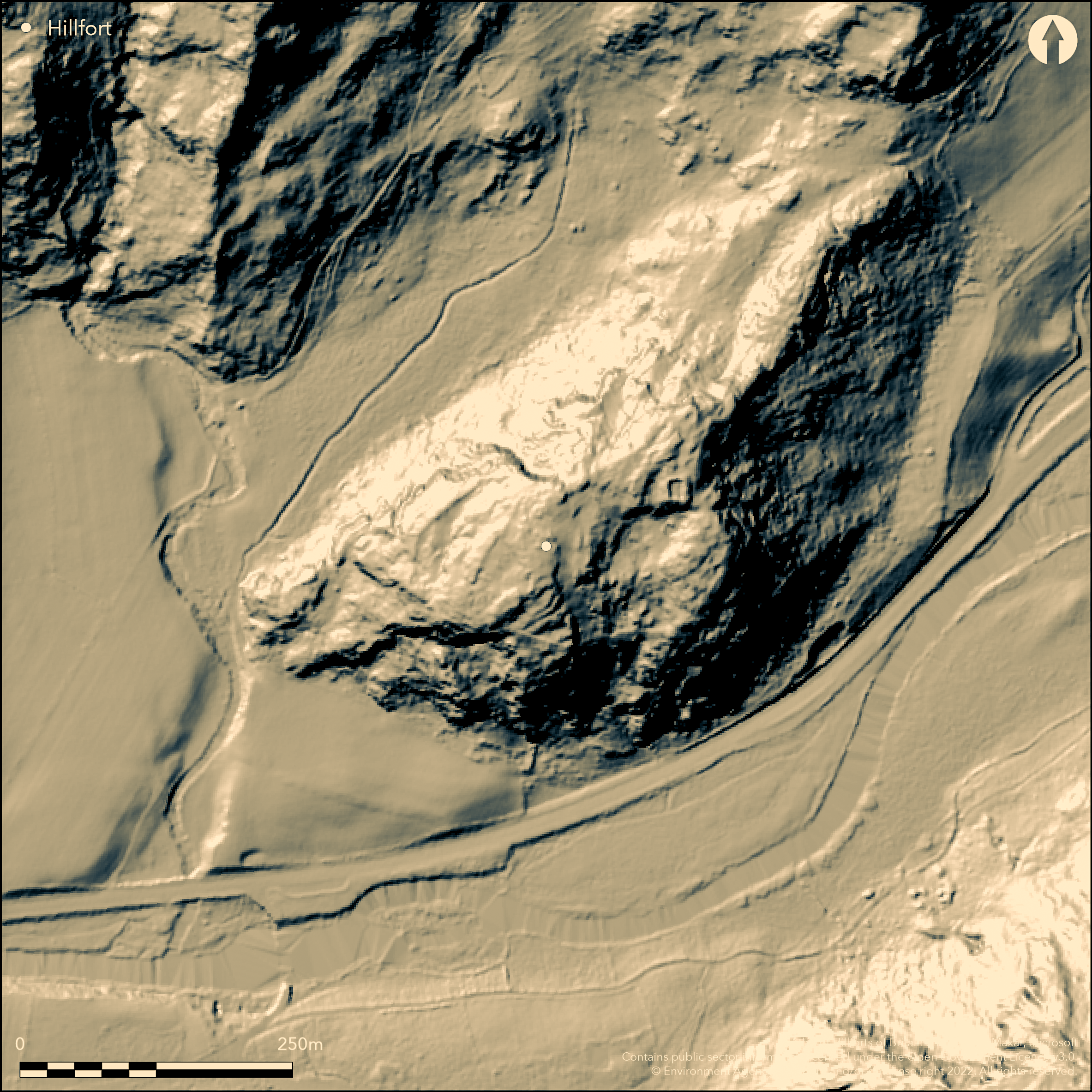
LiDAR 1m DTM Hillshade
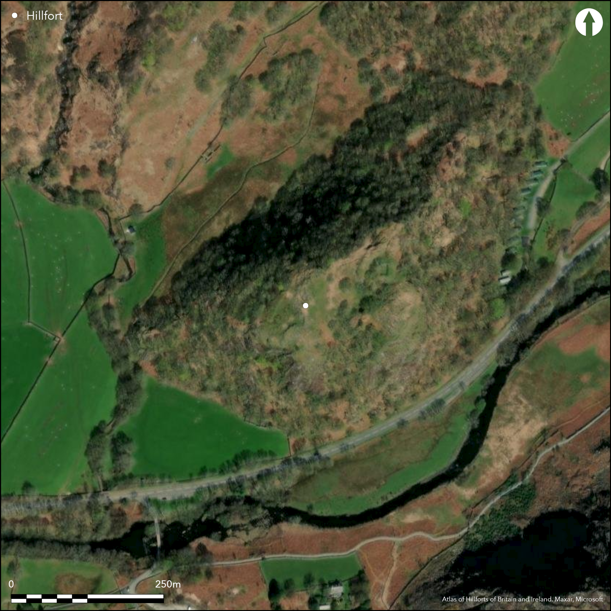
Satellite Imagery
LiDAR 1m DTM Hillshade
Satellite Imagery
Scroll left/right to view further images.
HER: Gwynedd 1462 (None)
NMR: SH 64 NW 2 (95284)
SM: CN018
NGR: SH60604920
X: 260600 Y: 349200 (OSGB36)
Complex contour hillfort located on summit of craggy volcanic outcrop in commanding position above Nant Gwynant and main route through mountains below Llyn Dinas. At confluence of stream and Afon Glaslyn upstream of Beddgelert. Steep surrounding slopes. Measures c. 200m E-W by 100m with internal area 1.2ha. Excavations 1910 (Breese 1930) and 1954-6 (Savory 1960), found Iron Age, Roman and early medieval (Dark Age) occupation, with some surviving stone-work possibly medieval. Main, inner enclosure entrance on W through ruinous wall beyond which two further lines of fallen walls with gateways, lowest close to foot of the rock. Route through the three gates torturous, involving blind alleys and zigzags. Razor-back ridge connecting the rock to mountain proper gives straightforward approach. All three ramparts ruinous, once c. 3m thick of rubble faced with laid stone. Where natural slopes sufficient walls absent or much reduced. Between middle and inner ramparts access hindered by natural crag c. 2m high, ending in precipice, only passed by narrow track. No ditches. Partially excavated by H.N.Savory to show main phases of occupation start with possible pre-Roman palisade, followed by early Romano-British phase with 1st century AD pottery. Later Romano-British phase has ceramics and glassware, including late 3rd or 4th century mortaria and colour coated wares. Glassware dated to late or post Roman. Imported amphora and sherd of pottery stamped with chi-rho symbol suggest early medieval use of the site and also period to which ramparts possibly date. Latest phase of activity is rectangular stone tower or keep, c. 13m by 11m, at top of hill and likely of reign of Llywelyn ap Iorwerth (d. AD 1240). There are questions over the site. C 14 AD date of 650+/- 100yrs unexpectedly late as the sample of wood from a posthole formerly thought Iron Age. Wooded slopes with interior trees, grass, scrub and bare rock throughout. Restoration work by National Trust. Legendary fortress of writings of 9th century writer Nennius of Vortigern, king who invited Saxons into kingdom to assist in its defence, and mythological Merlin. On 1st Ed. OS map (1885-1900).
Citizen Science: ✗
Reliability of Data: Confirmed
Reliability of Interpretation: Confirmed
X: -454160 Y: 6987044 (EPSG: 3857)
Longitude: -4.0797911656225665 Latitude: 53.0218701579298 (EPSG:4326)
Country: Wales
Current County or Unitary Authority: Gwynedd
Historic County: Caernarfonshire
Current Parish/Community/Council/Townland: Beddgelert
Work begun 2012 by National Trust to restore and reconsolidate eroded stonework of stone keep.
| Extant | ✓ |
| Cropmark | ✗ |
| Likely Destroyed | ✗ |
Wooded slopes with interior trees, grass, scrub. Bare rock throughout. Medieval remains.
| Woodland | ✓ |
| Commercial Forestry Plantation | ✗ |
| Parkland | ✗ |
| Pasture (Grazing) | ✗ |
| Arable | ✗ |
| Scrub/Bracken | ✓ |
| Bare Outcrop | ✗ |
| Heather/Moorland | ✗ |
| Heath | ✗ |
| Built-up | ✓ |
| Coastal Grassland | ✗ |
| Other | ✓ |
Contour hillfort located on summit of craggy volcanic outcrop in commanding position above Nant Gwynant and main route through mountains below Llyn Dinas. At confluence of stream and Afon Glaslyn upstream of Beddgelert. Steep surrounding slopes.
| Contour Fort | ✓ |
| Partial Contour Fort | ✗ |
| Promontory Fort | ✗ |
| Hillslope Fort | ✗ |
| Level Terrain Fort | ✗ |
| Marsh Fort | ✗ |
| Multiple Enclosure Fort | ✗ |
| Hilltop | ✗ |
| Coastal Promontory | ✗ |
| Inland Promontory | ✗ |
| Valley Bottom | ✗ |
| Knoll/Hillock/Outcrop | ✓ |
| Ridge | ✗ |
| Cliff/Plateau-edge/Scarp | ✗ |
| Hillslope | ✗ |
| Lowland | ✗ |
| Spur | ✗ |
Dominant Topographic Feature: Volcanic outcrop.
| North | ✗ |
| Northeast | ✗ |
| East | ✗ |
| Southeast | ✗ |
| South | ✗ |
| Southwest | ✗ |
| West | ✗ |
| Northwest | ✗ |
| Level | ✓ |
Altitude: 110.0m
N/A
Excavations, 1910 and 1954-6, found evidence for Iron Age, Roman and early medieval (Dark Age) occupation, and some surviving stone-work possibly medieval. Main phases of occupation start with possible pre- Roman palisade followed by early Romano-British phase with by 1st century AD pottery. Later Romano-British phase has ceramics and glassware, including late 3rd or 4th century mortaria and colour coated wares. Glassware dated to late or post Roman. Imported amphora and herd of pottery stamped with chi-rho symbol sugest early Medieval use of the site and also period to which ramparts possibly date. The latest phase of activity is rectangular stone tower, likely to belong the the reign of Llywelyn ap Iorwerth (d. AD 1240).
Reliability: B - Medium
| Pre 1200BC | ✗ |
| 1200BC - 800BC | ✗ |
| 800BC - 400BC | ✗ |
| 400BC - AD50 | ✓ |
| AD50 - AD400 | ✓ |
| AD400 - AD 800 | ✓ |
| Post AD800 | ✓ |
| Unknown | ✗ |
| Pre Hillfort: | None |
| Post Hillfort: | None |
| Artefactual: | Pottery |
| C14: | AD date of 650+/- 100yrs, unexpectedly late as the sample of wood from a post hole formerly thought Iron Age. |
On 1st Ed. OS map (1885-1900). Excavations 1910 C.E. Breese and 1954-6 H.N. Savory. Ordnance Survey observation 1976. Topographical and Geophysical Surveys I. Brooks, I. and K. Laws 2002. GAT prehistoric defended enclosures survey 2005-2006.
| Excavation (1910): | C.E. Breese. |
| Other (1976): | Ordnance Survey observation. |
| Geophysical Survey (2002): | I .Brooks and K. Laws. |
| Earthwork Survey (2002): | I. Brooks and K. Laws. |
| 1st Identified Map Depiction (None): | OS map. |
| Excavation (None): | H.N. Savory |
| Other (None): | GAT prehistoric defended enclosures survey. |
Later Romano-British ceramics and glassware, including late 3rd or 4th century mortaria and colour coated wares. Glassware dated to late or post Roman. Imported amphora and sherd of pottery stamped with chi-rho symbol suggest early Medieval use. Iron Age terret.
Afon Glaslyn/stream 0.2 km outside fort.
| None | ✓ |
| Spring | ✗ |
| Stream | ✗ |
| Pool | ✗ |
| Flush | ✗ |
| Well | ✗ |
| Other | ✗ |
None
| No Known Features | ✓ |
| Round Stone Structures | ✗ |
| Rectangular Stone Structures | ✗ |
| Curvilinear Platforms | ✗ |
| Other Roundhouse Evidence | ✗ |
| Pits | ✗ |
| Quarry Hollows | ✗ |
| Other | ✗ |
None
| No Known Excavation | ✗ |
| Pits | ✗ |
| Postholes | ✓ |
| Roundhouses | ✗ |
| Rectangular Structures | ✗ |
| Roads/Tracks | ✗ |
| Quarry Hollows | ✗ |
| Other | ✗ |
| Nothing Found | ✗ |
No details.
| No Known Geophysics | ✗ |
| Pits | ✗ |
| Roundhouses | ✗ |
| Rectangular Structures | ✗ |
| Roads/Tracks | ✗ |
| Quarry Hollows | ✗ |
| Other | ✓ |
| Nothing Found | ✗ |
Later Romano-British ceramics and glassware, including late 3rd or 4th century mortaria and colour coated wares. Glassware dated to late or post Roman. Imported amphora and sherd of pottery stamped with chi-rho symbol suggest early Medieval use. Iron Age terret.
| No Known Finds | ✗ |
| Pottery | ✓ |
| Metal | ✗ |
| Metalworking | ✗ |
| Human Bones | ✗ |
| Animal Bones | ✗ |
| Lithics | ✗ |
| Environmental | ✗ |
| Other | ✓ |
None
| APs Not Checked | ✓ |
| None | ✗ |
| Roundhouses | ✗ |
| Rectangular Structures | ✗ |
| Pits | ✗ |
| Postholes | ✗ |
| Roads/Tracks | ✗ |
| Other | ✗ |
Main, inner enclosure entrance on W through ruinous wall beyond which are two further lines of fallen walls with gateways, the lowest close to the foot of the rock. Route through the three gates torturous, involving blind alleys and zigzags. Razor-back ridge connecting the rock to mountain proper offers relatively straightforward approach.
| 3: | Estimated only. |
| 2: | None |
Guard Chambers: ✗
Chevaux de Frise: ✗
| 1. Simple Gap (West): | Through inner rampart. |
| 1. Simple Gap (West): | Route through the three gates torturous, involving blind alleys and zigzags. |
| 2. Simple Gap (West): | Through middle rampart. |
| 2. Simple Gap (West): | Route through the three gates torturous, involving blind alleys and zigzags. |
| 3. Simple Gap (West): | Through outer rampart. |
| 3. Simple Gap (West): | Route through the three gates torturous, involving blind alleys and zigzags. |
All three ramparts ruinous, once c. 3m thick of rubble faced with laid stone. Where natural slopes sufficient defence walls absent or much reduced. Between middle and inner ramparts access hindered by natural crag c. 2m high, ending in precipice, only passed by narrow track. No ditches. 1.2ha.
| Area 1: | 1.2ha. |
| Total: | 1.2ha. |
Total Footprint Area: Noneha.
None
| ✓ | Phased construction. |
| ✓ | None |
| NE Quadrant: | 1 |
| SE Quadrant: | 2 |
| SW Quadrant: | 3 |
| NW Quadrant: | 2 |
| Total: | 3 |
| Partial Univallate | ✓ |
| Univallate | ✗ |
| Partial Bivallate | ✓ |
| Bivallate | ✗ |
| Partial Multivallate | ✓ |
| Multivallate | ✗ |
| Unknown | ✗ |
| Partial Univallate | ✗ |
| Univallate | ✓ |
| Partial Bivallate | ✗ |
| Bivallate | ✗ |
| Partial Multivallate | ✗ |
| Multivallate | ✗ |
Stone-walled site.
| None | ✗ |
| Earthen Bank | ✗ |
| Stone Wall | ✓ |
| Rubble | ✗ |
| Wall-walk | ✗ |
| Evidence of Timber | ✗ |
| Vitrification | ✗ |
| Other Burning | ✗ |
| Palisade | ✗ |
| Counter Scarp Bank | ✗ |
| Berm | ✗ |
| Unfinished | ✗ |
| Other | ✗ |
Main phases of occupation start with possible pre-Roman palisade,
| None | ✗ |
| Earthen Bank | ✗ |
| Stone Wall | ✓ |
| Murus Duplex | ✗ |
| Timber-framed | ✗ |
| Timber-laced | ✗ |
| Vitrification | ✗ |
| Other Burning | ✗ |
| Palisade | ✓ |
| Counter Scarp Bank | ✗ |
| Berm | ✗ |
| Unfinished | ✗ |
| No Known Excavation | ✗ |
| Other | ✗ |
| ✗ | None |
| ✗ | None |
Number of Ditches: 0
| ✗ | None |
Breese, C. E. 1930. The Fort of Dinas Emrys, Arch Camb, LXXXV Pt 2, 342-354.
Brooks, I. and Laws, K. 2002. Topographical and Geophysical Surveys at Dinas Emrys, EAS REPORT 2002/38.
RCAHMW 1960. Caernarvonshire Vol II: Central, A survey and inventory by the Royal Commission on Ancient and Historical Monuments in Wales and Monmouthshire, No 742, London: HMSO.
Savory, H. N. 1960. Excavations at Dinas Emrys, Beddgelert 1954-1956, Arch Camb, CIX ,P13-77.
Smith, G.H. 2006. A survey of prehistoric defended enclosures in north-west Wales 2005-2006: Gwynedd Dwyfor and Meirionnydd. Report No 634. Part I: Survey Report. Bangor: Gwynedd Archaeological Trust.
Waddington, K. 2013. The Settlements of Northwest Wales: From the Late Bronze Age to the Early Medieval Period, Cardiff: University of Wales Press.
Atlas of Hillforts:
Wikidata:
This work is licensed under CC BY-SA 4.0

 and should be cited as:
Lock, Gary and Ralston, Ian. 2024. Atlas of Hillforts of Britain and Ireland. Available at: https://hillforts.arch.ox.ac.uk
Document Version 1.1