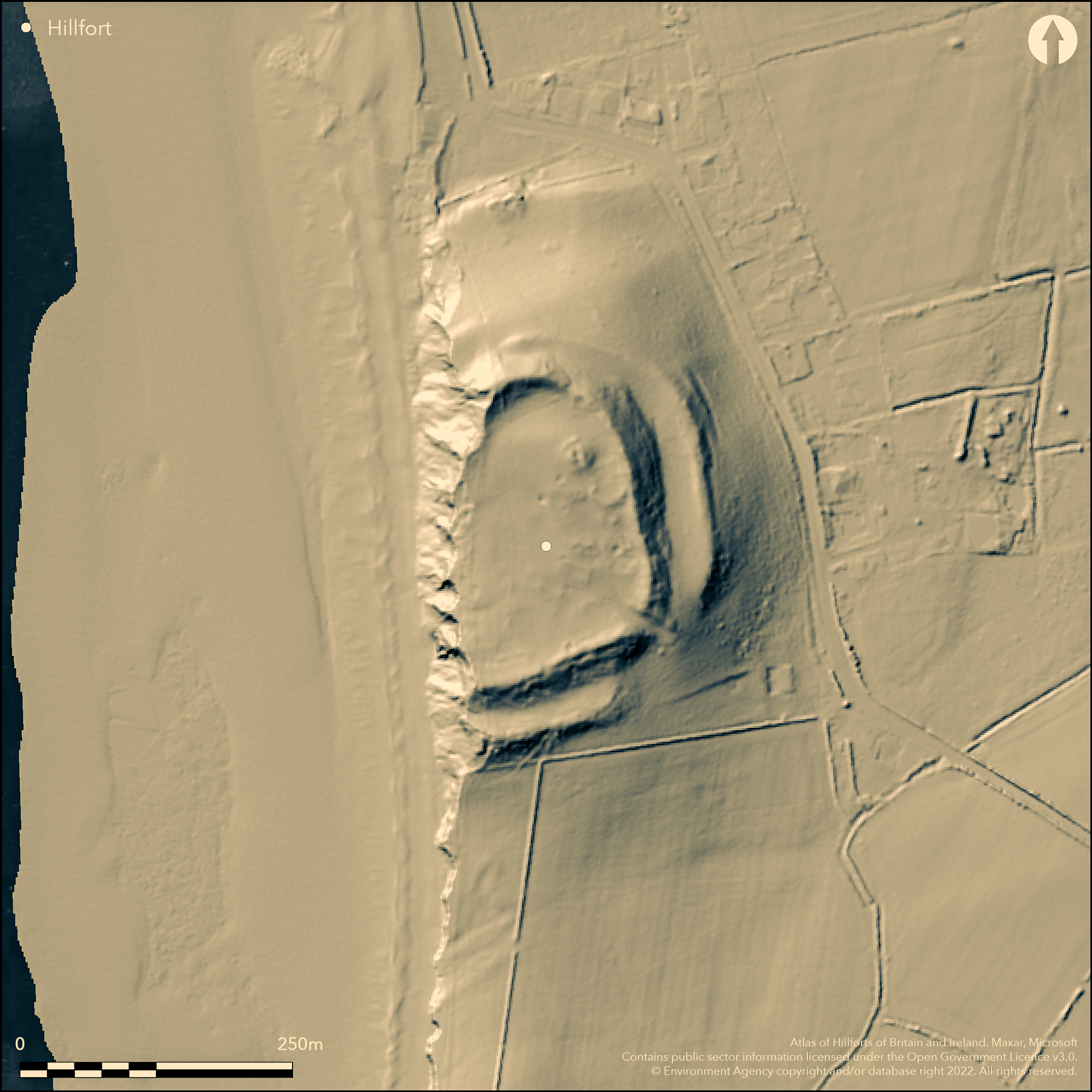
LiDAR 1m DTM Hillshade
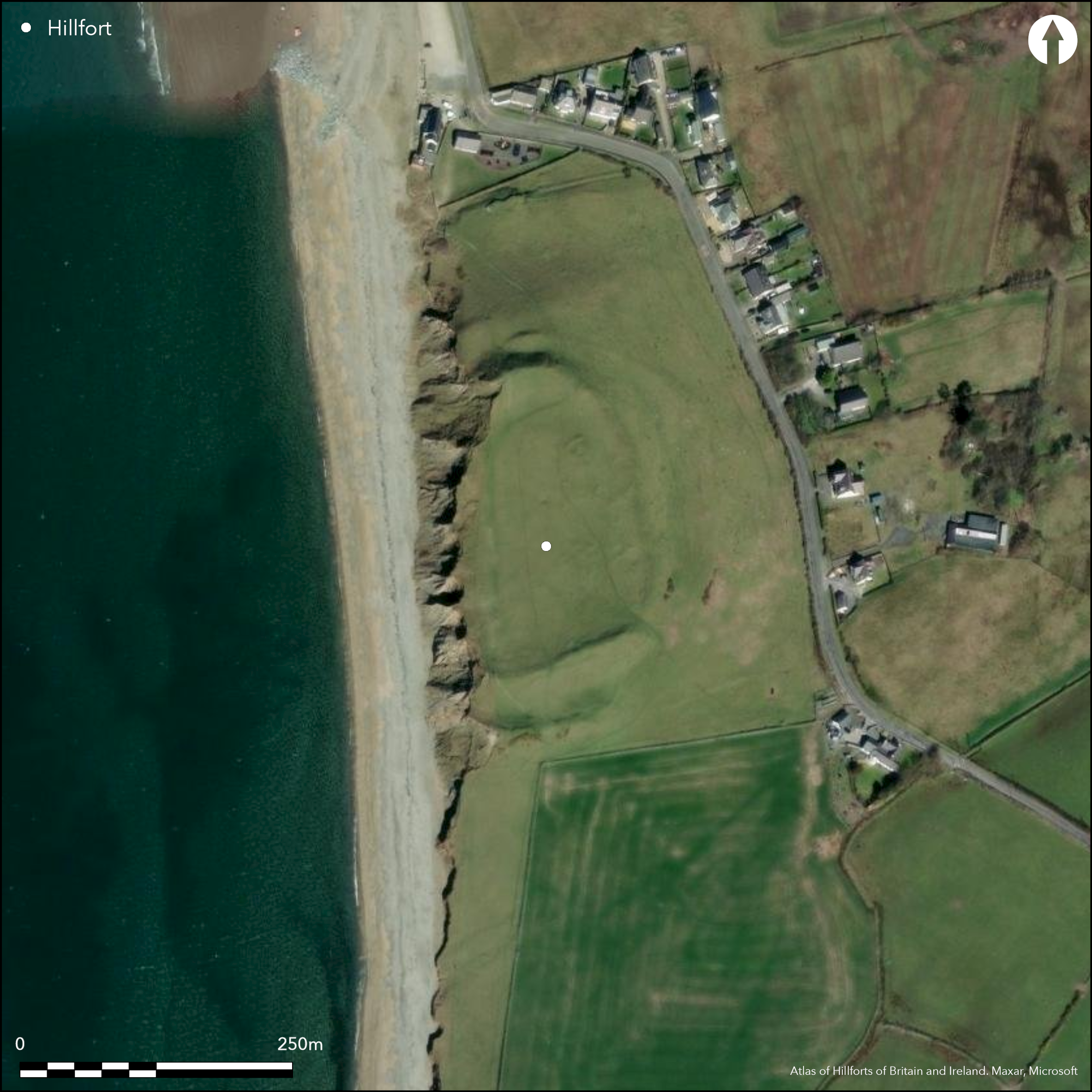
Satellite Imagery
LiDAR 1m DTM Hillshade
Satellite Imagery
Scroll left/right to view further images.
HER: Gwynedd 1570 (None)
NMR: SH 45 NW 1 (95309)
SM: CN048
NGR: SH43705635
X: 243700 Y: 356350 (OSGB36)
Contour hillfort sited on eroding fast glacial drumlin immediately above beach and sea at Llandwrog. One of the few coastal forts in north Wales. Surrounding slopes very steep to N, S and E, W precipitous to beach. Measures c. 150m N-S by 110m with internal area 1.6ha. Subject to considerable coastal erosion which has taken all of W ramparts, giving the site a promontory nature, but undoubtedly located someway inland in prehistory. Elsewhere two massive banks (up to 6 m) with deep intervening ditch are well shown. Inner bank was faced with stone boulders from the beach and ramparts constructed of drift. Inner rampart internal height 2m to 2.6m on S and E sides to over 3.6m on N. Outer rampart overall depth of 3.6 - 11.6m to the bottom of the intervening ditch. Fine wide and simple entrance on SE. Circular buildings and structures in E interior. Casual finds include Roman coins, intaglio and sherds. Possible Bronze Age barrow. Coastal grassland . Site gradually being lost to sea. On 1st Ed. OS map (1888-91). Minimal investigations, undated.
Citizen Science: ✗
Reliability of Data: Confirmed
Reliability of Interpretation: Confirmed
X: -482571 Y: 6998073 (EPSG: 3857)
Longitude: -4.335010106147203 Latitude: 53.08141943311123 (EPSG:4326)
Country: Wales
Current County or Unitary Authority: Gwynedd
Historic County: Caernarfonshire
Current Parish/Community/Council/Townland: Llandwrog
Subject to considerable coastal erosion which has taken all of the W ramparts. WWII Seagull Trench (built in the lower N-facing ramparts of the fort. Site gradually being lost to sea.
| Extant | ✓ |
| Cropmark | ✗ |
| Likely Destroyed | ✓ |
Good coastal grassland.
| Woodland | ✗ |
| Commercial Forestry Plantation | ✗ |
| Parkland | ✗ |
| Pasture (Grazing) | ✗ |
| Arable | ✗ |
| Scrub/Bracken | ✗ |
| Bare Outcrop | ✗ |
| Heather/Moorland | ✗ |
| Heath | ✗ |
| Built-up | ✗ |
| Coastal Grassland | ✓ |
| Other | ✗ |
Contour hillfort sited on fast eroding glacial drumlin immediately above beach and sea at Llandwrog. One of the few coastal forts in north Wales. Surrounding slopes very steep to N, S and E, W precipitous to beach.
| Contour Fort | ✓ |
| Partial Contour Fort | ✗ |
| Promontory Fort | ✗ |
| Hillslope Fort | ✗ |
| Level Terrain Fort | ✗ |
| Marsh Fort | ✗ |
| Multiple Enclosure Fort | ✗ |
| Hilltop | ✗ |
| Coastal Promontory | ✗ |
| Inland Promontory | ✗ |
| Valley Bottom | ✗ |
| Knoll/Hillock/Outcrop | ✓ |
| Ridge | ✗ |
| Cliff/Plateau-edge/Scarp | ✗ |
| Hillslope | ✗ |
| Lowland | ✗ |
| Spur | ✗ |
Dominant Topographic Feature: Glacial outcrop
| North | ✗ |
| Northeast | ✗ |
| East | ✗ |
| Southeast | ✗ |
| South | ✗ |
| Southwest | ✗ |
| West | ✗ |
| Northwest | ✗ |
| Level | ✓ |
Altitude: 31.0m
N/A
No dating evidence other than Roman.
Reliability: D - None
| Pre 1200BC | ✗ |
| 1200BC - 800BC | ✗ |
| 800BC - 400BC | ✗ |
| 400BC - AD50 | ✗ |
| AD50 - AD400 | ✗ |
| AD400 - AD 800 | ✗ |
| Post AD800 | ✗ |
| Unknown | ✓ |
| Pre Hillfort: | Possible Bronze Age barrow. |
| Post Hillfort: | Evidence of Roman 2nd and 3rd century AD occupation. Possible Roman pharos or lighthouse, similar to one to the north on Caer y Twr, Holyhead Mountain. WWII Seagull Trench (built in the lower N-facing ramparts of the fort. Casual finds, including Roman coins of A.D. 253 to 296, an intaglio and a sherd of black burnished ware of the second or third centuries, indicate occupation in Roman period. |
On 1st Ed. OS map (1888-91). Ordnance Survey observation 1968, 1972. GAT site investigation 1990. GAT Coastal Erosion Survey: Aberdaron Bay to the Great Orme 1999. GAT prehistoric defended enclosures survey 2004-2005, plus geophysics. GAT Watching Briefs. 2009, 2010. Photographic aerial survey T. Driver, RCAHMW 2013.
| Other (1990): | GAT investigation. |
| Other (1999): | GAT Coastal Erosion Survey: Aberdaron Bay to the Great Orme. |
| Geophysical Survey (2005): | None |
| Other (2005): | Visited by Hillfort Study Group |
| Other (2013): | Photographic aerial survey T. Driver, RCAHMW. |
| 1st Identified Map Depiction (None): | OS map. |
| Other (None): | Ordnance Survey observation. |
| Other (None): | GAT prehistoric defended enclosures survey. |
| Other (None): | GAT Watching Briefs. |
Within E part of the interior traces of circular or rectangular structures or enclosures, one being possible sepulchral mound or alternatively a Roman pharos or lighthouse, similar to one to the north on Caer y Twr, Holyhead Mountain.
Stream 0.1km outside fort.
| None | ✓ |
| Spring | ✗ |
| Stream | ✗ |
| Pool | ✗ |
| Flush | ✗ |
| Well | ✗ |
| Other | ✗ |
Within E part of the interior traces of circular or rectangular structures or enclosures, one being possible sepulchral mound or alternatively a Roman pharos or lighthouse, similar to one to the north on Caer y Twr, Holyhead Mountain. Two linear breaks of slope identified in the central part of the fort appearance of regular terracing. Low banks and potential platform against the S inner rampart (Driver 2013 - Coflein).
| No Known Features | ✗ |
| Round Stone Structures | ✗ |
| Rectangular Stone Structures | ✗ |
| Curvilinear Platforms | ✗ |
| Other Roundhouse Evidence | ✓ |
| Pits | ✗ |
| Quarry Hollows | ✗ |
| Other | ✗ |
None
| No Known Excavation | ✓ |
| Pits | ✗ |
| Postholes | ✗ |
| Roundhouses | ✗ |
| Rectangular Structures | ✗ |
| Roads/Tracks | ✗ |
| Quarry Hollows | ✗ |
| Other | ✗ |
| Nothing Found | ✗ |
None
| No Known Geophysics | ✗ |
| Pits | ✗ |
| Roundhouses | ✓ |
| Rectangular Structures | ✗ |
| Roads/Tracks | ✗ |
| Quarry Hollows | ✗ |
| Other | ✗ |
| Nothing Found | ✗ |
Casual finds, including Roman coins of A.D. 253 to 296, an intaglio and a sherd of black burnished ware of the second or third centuries AD.
| No Known Finds | ✗ |
| Pottery | ✓ |
| Metal | ✗ |
| Metalworking | ✗ |
| Human Bones | ✗ |
| Animal Bones | ✗ |
| Lithics | ✓ |
| Environmental | ✗ |
| Other | ✓ |
None
| APs Not Checked | ✓ |
| None | ✗ |
| Roundhouses | ✗ |
| Rectangular Structures | ✗ |
| Pits | ✗ |
| Postholes | ✗ |
| Roads/Tracks | ✗ |
| Other | ✗ |
Fine wide and simple entrance on SE.
| 1: | Much of site lost seaward to W. |
| 2: | Wide entrance gap. |
Guard Chambers: ✗
Chevaux de Frise: ✗
| 1. Simple Gap (South east): | None |
Subject to considerable coastal erosion which has taken all of W ramparts, giving the site a promontory nature, but undoubtedly located someway inland in prehistory. Elsewhere two massive banks (up to 6 m) with deep intervening ditch are well shown. Inner bank was faced with stone boulders from the beach and ramparts constructed of drift. Inner rampart internal height 2m to 2.6m on S and E sides to over 3.6m on N. Outer rampart overall depth of 3.6 - 11.6m to the bottom of the intervening ditch. 1.6ha.
| Area 1: | 1.6ha. |
| Total: | 1.6ha. |
Total Footprint Area: Noneha.
None
| ✗ | None |
| ✗ | W side eroded away. |
| NE Quadrant: | 2 |
| SE Quadrant: | 2 |
| SW Quadrant: | 0 |
| NW Quadrant: | 0 |
| Total: | 2 |
| Partial Univallate | ✗ |
| Univallate | ✗ |
| Partial Bivallate | ✓ |
| Bivallate | ✗ |
| Partial Multivallate | ✗ |
| Multivallate | ✗ |
| Unknown | ✗ |
| Partial Univallate | ✗ |
| Univallate | ✗ |
| Partial Bivallate | ✗ |
| Bivallate | ✗ |
| Partial Multivallate | ✗ |
| Multivallate | ✗ |
As result of the erosion, section through the ramparts at S end visible, revealing the boulder-facing to inner rampart.
| None | ✗ |
| Earthen Bank | ✓ |
| Stone Wall | ✓ |
| Rubble | ✗ |
| Wall-walk | ✗ |
| Evidence of Timber | ✗ |
| Vitrification | ✗ |
| Other Burning | ✗ |
| Palisade | ✗ |
| Counter Scarp Bank | ✗ |
| Berm | ✗ |
| Unfinished | ✗ |
| Other | ✗ |
None
| None | ✗ |
| Earthen Bank | ✗ |
| Stone Wall | ✗ |
| Murus Duplex | ✗ |
| Timber-framed | ✗ |
| Timber-laced | ✗ |
| Vitrification | ✗ |
| Other Burning | ✗ |
| Palisade | ✗ |
| Counter Scarp Bank | ✗ |
| Berm | ✗ |
| Unfinished | ✗ |
| No Known Excavation | ✓ |
| Other | ✗ |
| ✗ | None |
| ✓ | Intervening ditch. |
Number of Ditches: 1
| ✗ | None |
Brooks, I. Engineering Archaeological Services 2009. Dinas Dinlle Hillfort Footpath Watching Brief, EAS 2009/1.
Evans, R. and Jones, M. 2010. Dinas Dinlle Hillfort, Llandwrog, GAT Report No. 847, Bangor: Gwynedd Archaeological Trust.
Latham, J. 2010. Dinas Dinlle: erosion and conservation, The Archaeologist, IFA Magazine No. 75 Spring 2010.
RCAHMW 1960. Caernarvonshire Vol II: Central, A survey and inventory by the Royal Commission on Ancient and Historical Monuments in Wales and Monmouthshire, No 1211, London: HMSO.
Riley, H. and Smith, G. 1993. Coastal Erosion Survey: Aberdaron Bay to the Great Orme, GAT Report No.079, Bangor: Gwynedd Archaeological Trust.
Smith, G. H. 2005 , A Survey of Prehistoric Defended Enclosures in North West Wales 2004-2005: West Conwy, Gwynedd (Arfon) and Anglesey, Bangor: Gwynedd Archaeological Trust.
Waddington, K. 2013. The Settlements of Northwest Wales: From the Late Bronze Age to the Early Medieval Period, Cardiff: University of Wales Press.
Atlas of Hillforts:
Wikidata:
This work is licensed under CC BY-SA 4.0

 and should be cited as:
Lock, Gary and Ralston, Ian. 2024. Atlas of Hillforts of Britain and Ireland. Available at: https://hillforts.arch.ox.ac.uk
Document Version 1.1