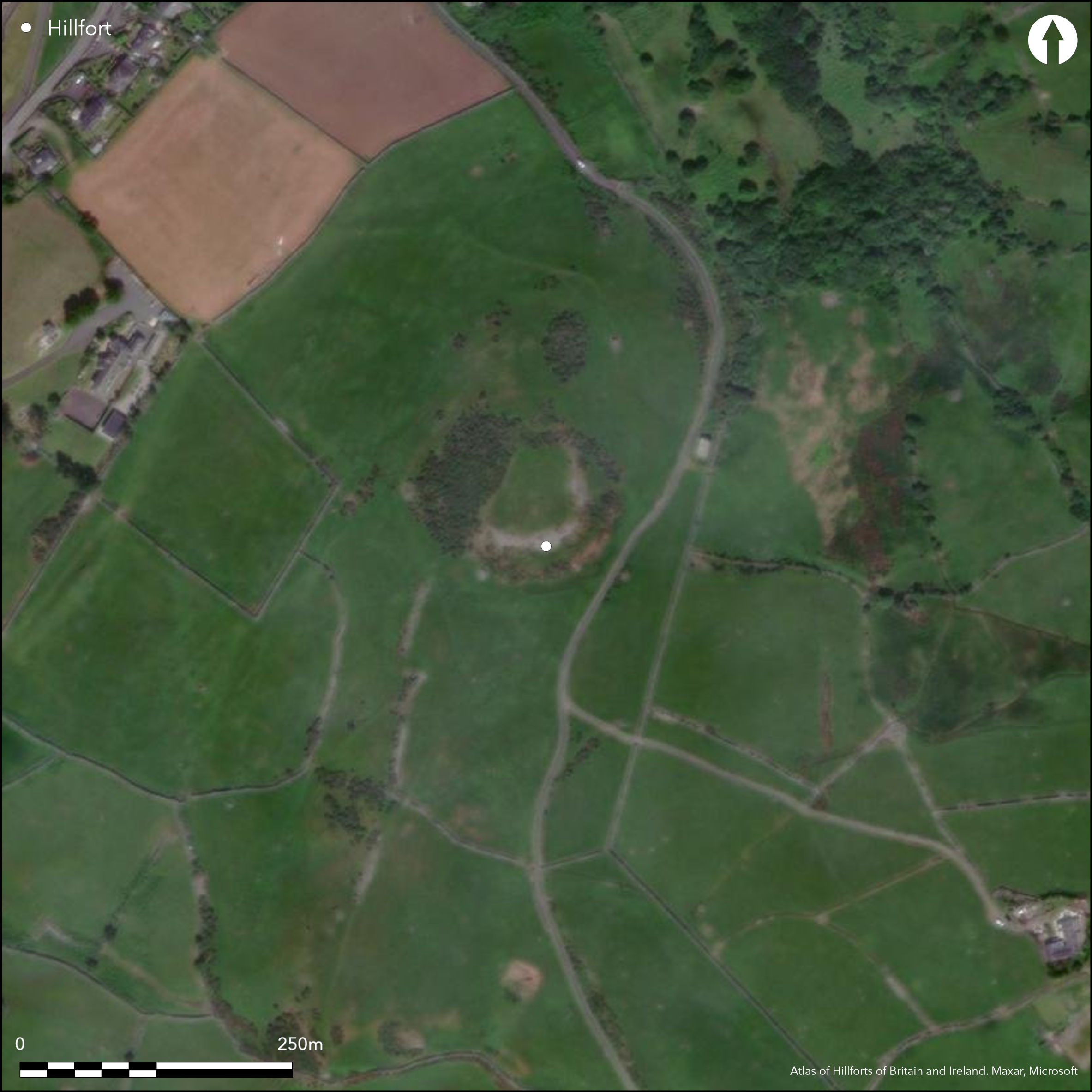
Satellite Imagery
Satellite Imagery
HER: Gwynedd 4919 (None)
NMR: SH 50 NE 3 (302716)
SM: ME053
NGR: SH59200900
X: 259200 Y: 309000 (OSGB36)
Small contour hillfort sited on a small rounded spur overlooking the mouth of the Afon Gwril, the narrow coastal flats and the sea. Surrounding slopes N and W very steep, S and E steep. Measures c. 60m N-S by 30m-44m with internal area 0.16ha. Stone and earth defences of possible single design. Main inner defence of a stone wall surrounding the flat top of the spur, some 3.6m to 4.5m wide at its base, has been heavily robbed for stone, with only remnants left on S and E sides. A small scarp is formed by the cutting back of the natural slope. Across the neck of the spur is an impressive bank between two ditches, rising to about 3.6m from the bottom of the outer ditch. Entrance through the stone wall about 2.4m wide on the SE side and curved between the bank to N, which is raised in height. Pasture interior. Wooded ramparts and slopes on W. Outer ramparts in scattered trees on E. On 1st Ed. OS map (1889). Minimal investigations, undated.
Citizen Science: ✗
Reliability of Data: Confirmed
Reliability of Interpretation: Confirmed
X: -454549 Y: 6920420 (EPSG: 3857)
Longitude: -4.083286117829291 Latitude: 52.66036289888358 (EPSG:4326)
Country: Wales
Current County or Unitary Authority: Gwynedd
Historic County: Merioneth
Current Parish/Community/Council/Townland: Llangelynin
Robbed, but still impressive in places.
| Extant | ✓ |
| Cropmark | ✗ |
| Likely Destroyed | ✗ |
Pasture interior. Wooded ramparts and slopes on W. Outer ramparts scattered trees on E.
| Woodland | ✓ |
| Commercial Forestry Plantation | ✗ |
| Parkland | ✗ |
| Pasture (Grazing) | ✓ |
| Arable | ✗ |
| Scrub/Bracken | ✗ |
| Bare Outcrop | ✗ |
| Heather/Moorland | ✗ |
| Heath | ✗ |
| Built-up | ✗ |
| Coastal Grassland | ✗ |
| Other | ✗ |
Small contour hillfort sited on a small rounded spur overlooking the mouth of the Afon Gwril, the narrow coastal flats and the sea. Surrounding slopes N and W very steep, S and E steep.
| Contour Fort | ✓ |
| Partial Contour Fort | ✗ |
| Promontory Fort | ✗ |
| Hillslope Fort | ✗ |
| Level Terrain Fort | ✗ |
| Marsh Fort | ✗ |
| Multiple Enclosure Fort | ✗ |
| Hilltop | ✗ |
| Coastal Promontory | ✗ |
| Inland Promontory | ✗ |
| Valley Bottom | ✗ |
| Knoll/Hillock/Outcrop | ✗ |
| Ridge | ✗ |
| Cliff/Plateau-edge/Scarp | ✗ |
| Hillslope | ✗ |
| Lowland | ✗ |
| Spur | ✓ |
Dominant Topographic Feature: Spur
| North | ✗ |
| Northeast | ✗ |
| East | ✗ |
| Southeast | ✗ |
| South | ✗ |
| Southwest | ✗ |
| West | ✗ |
| Northwest | ✗ |
| Level | ✓ |
Altitude: 130.0m
N/A
None
Reliability: D - None
| Pre 1200BC | ✗ |
| 1200BC - 800BC | ✗ |
| 800BC - 400BC | ✗ |
| 400BC - AD50 | ✗ |
| AD50 - AD400 | ✗ |
| AD400 - AD 800 | ✗ |
| Post AD800 | ✗ |
| Unknown | ✓ |
| Pre Hillfort: | None |
| Post Hillfort: | None |
On 1st Ed. OS map (1889). Ordnance Survey observation 1973. GAT investigations 1993, 1994, 1995, 2005 (Llwyngwril Waste Water Treatment Scheme, Wastewater Treatment Works assessments). GAT prehistoric defended enclosures survey 2005-2006.
| 1st Identified Map Depiction (1889): | OS map. |
| Other (1973): | Ordnance Survey observation. |
| Other (None): | GAT investigations. |
| Other (None): | GAT prehistoric defended enclosures survey. |
Possible rectangular structure.
Stream 0.25km outside fort.
| None | ✓ |
| Spring | ✗ |
| Stream | ✗ |
| Pool | ✗ |
| Flush | ✗ |
| Well | ✗ |
| Other | ✗ |
Possible rectangular structure.
| No Known Features | ✗ |
| Round Stone Structures | ✗ |
| Rectangular Stone Structures | ✓ |
| Curvilinear Platforms | ✗ |
| Other Roundhouse Evidence | ✗ |
| Pits | ✗ |
| Quarry Hollows | ✗ |
| Other | ✗ |
None
| No Known Excavation | ✓ |
| Pits | ✗ |
| Postholes | ✗ |
| Roundhouses | ✗ |
| Rectangular Structures | ✗ |
| Roads/Tracks | ✗ |
| Quarry Hollows | ✗ |
| Other | ✗ |
| Nothing Found | ✗ |
None
| No Known Geophysics | ✓ |
| Pits | ✗ |
| Roundhouses | ✗ |
| Rectangular Structures | ✗ |
| Roads/Tracks | ✗ |
| Quarry Hollows | ✗ |
| Other | ✗ |
| Nothing Found | ✗ |
None
| No Known Finds | ✓ |
| Pottery | ✗ |
| Metal | ✗ |
| Metalworking | ✗ |
| Human Bones | ✗ |
| Animal Bones | ✗ |
| Lithics | ✗ |
| Environmental | ✗ |
| Other | ✗ |
None
| APs Not Checked | ✓ |
| None | ✗ |
| Roundhouses | ✗ |
| Rectangular Structures | ✗ |
| Pits | ✗ |
| Postholes | ✗ |
| Roads/Tracks | ✗ |
| Other | ✗ |
Entrance through the stone wall about 2.4m wide on the SE side and curved between the bank to N, which is raised in height.
| None: | Robbed wall makes interpretation difficult. |
| 2: | None |
Guard Chambers: ✗
Chevaux de Frise: ✗
| 1. Over-lapping (South east): | Off-set entrance. |
Stone and earth defences of possible single design. Main inner defence of a stone wall surrounding the flat top of the spur, some 3.6m to 4.5m wide at its base, has been heavily robbed for stone, with only remnants left on S and E sides. A small scarp is formed by the cutting back of the natural slope. Across the neck of the spur is an impressive bank between two ditches, rising to about 3.6m from the bottom of the outer ditch. 0.16ha.
| Area 1: | 0.16ha. |
| Total: | 0.16ha. |
Total Footprint Area: Noneha.
None
| ✗ | None |
| ✓ | None |
| NE Quadrant: | 2 |
| SE Quadrant: | 1 |
| SW Quadrant: | 1 |
| NW Quadrant: | 2 |
| Total: | 2 |
| Partial Univallate | ✓ |
| Univallate | ✗ |
| Partial Bivallate | ✓ |
| Bivallate | ✗ |
| Partial Multivallate | ✗ |
| Multivallate | ✗ |
| Unknown | ✗ |
| Partial Univallate | ✗ |
| Univallate | ✗ |
| Partial Bivallate | ✗ |
| Bivallate | ✗ |
| Partial Multivallate | ✗ |
| Multivallate | ✗ |
Stone and earth defences of possible single design.
| None | ✗ |
| Earthen Bank | ✓ |
| Stone Wall | ✓ |
| Rubble | ✗ |
| Wall-walk | ✗ |
| Evidence of Timber | ✗ |
| Vitrification | ✗ |
| Other Burning | ✗ |
| Palisade | ✗ |
| Counter Scarp Bank | ✗ |
| Berm | ✗ |
| Unfinished | ✗ |
| Other | ✗ |
None
| None | ✗ |
| Earthen Bank | ✗ |
| Stone Wall | ✗ |
| Murus Duplex | ✗ |
| Timber-framed | ✗ |
| Timber-laced | ✗ |
| Vitrification | ✗ |
| Other Burning | ✗ |
| Palisade | ✗ |
| Counter Scarp Bank | ✗ |
| Berm | ✗ |
| Unfinished | ✗ |
| No Known Excavation | ✓ |
| Other | ✗ |
| ✗ | None |
| ✓ | None |
Number of Ditches: 2
| ✗ | None |
Bowen, E.G. and Gresham, C.A. 1967. History of Merioneth,1, Dolgellau, 153-55.
RCAHMW 1921. An inventory of the ancient monuments in Wales and Monmouthshire, VI, County of Merioneth, 128, 416, London: HMSO.
Smith, G.H. 2006. A survey of prehistoric defended enclosures in north-west Wales 2005-2006: Gwynedd Dwyfor and Meirionnydd. Report No 634. Part I: Survey Report. Bangor: Gwynedd Archaeological Trust.
Waddington, K. 2013. The Settlements of Northwest Wales: From the Late Bronze Age to the Early Medieval Period, Cardiff: University of Wales Press.
Atlas of Hillforts:
Wikidata:
This work is licensed under CC BY-SA 4.0

 and should be cited as:
Lock, Gary and Ralston, Ian. 2024. Atlas of Hillforts of Britain and Ireland. Available at: https://hillforts.arch.ox.ac.uk
Document Version 1.1