Satellite Imagery
Satellite Imagery
HER: Dyfed 549 (None)
NMR: SR 99 NW (94106)
SM: PE021(PEM)
NGR: SR 9028 9662
X: 190280 Y: 196620 (OSGB36)
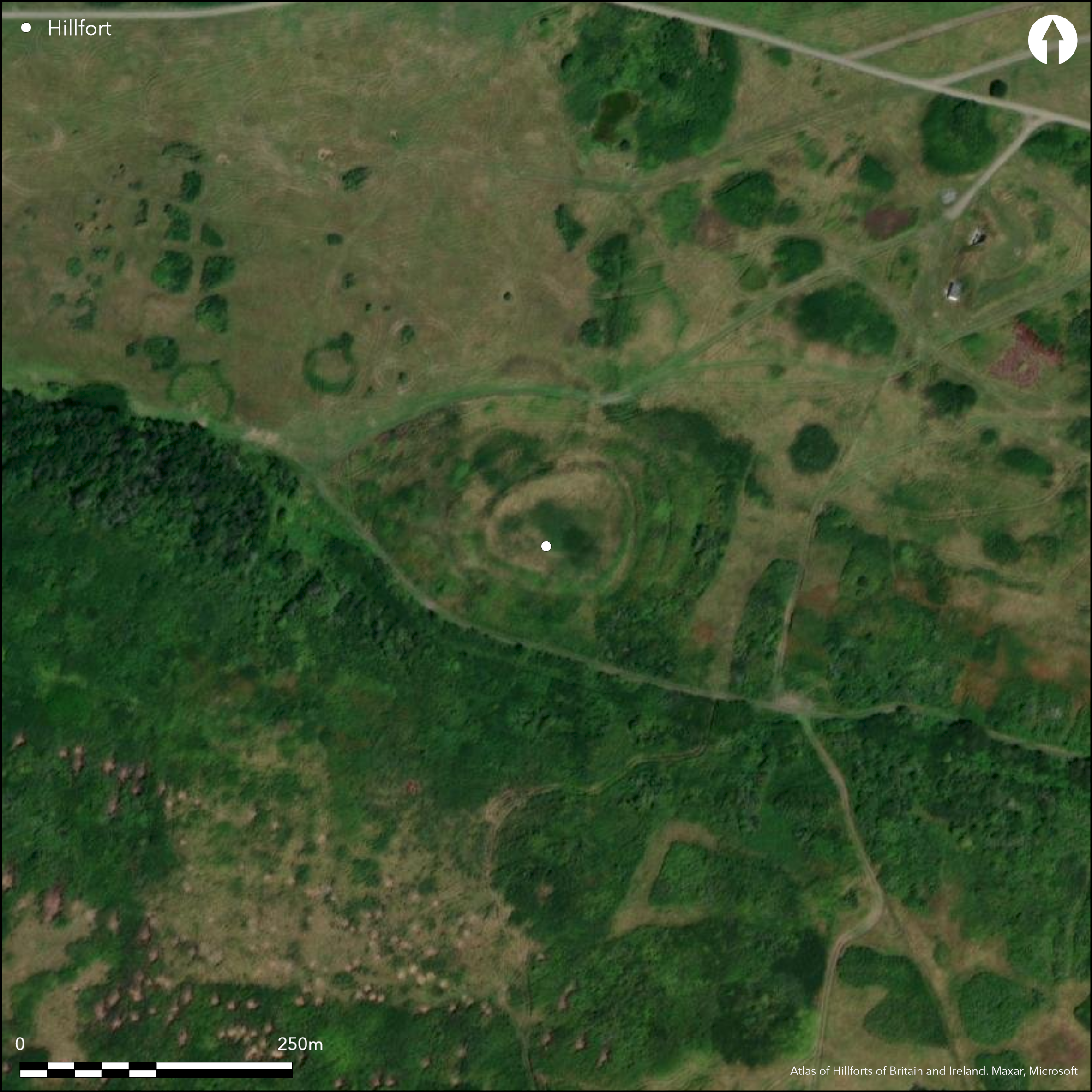
Fine, heavily enclosed, multivallate partial contour hillfort located on slight hillock on edge of moderate to strong SSW-facing slopes to Castle Lady Valley c. 10m below. Near Brownslade Burrows and the sea to W. Just to W of Warman's Hill fort (Atlas No 1811). Overlooked from N, but commanding and intimidating position guarding the access to the sea and landings W down the Castle Lady Valley. Moderate to strong surrounding slopes. Oval shaped measuring c. 74m E-W by 62m, with internal area 0.6ha. An inner bank and ditch encloses the fairly level interior for the complete circuit with entrance on N side. Three further outer banks and ditches to W, with entrance gap between them and passageway to inner gap on N. Three slighter outer banks and ditches lie on E side. To N and S sides scarped natural slopes. RCAHMW (Coflein) suggest 19th century reports of 'well made pottery' may suggest Romano-British, or post-Roman occupation. Interior pasture and banks were largely cleared of scrub by Defence Estates. Within MOD Firing Range Danger Area. On 1st Ed. OS map (1865). Minimal investigations, undated.
Citizen Science: ✗
Reliability of Data: Confirmed
Reliability of Interpretation: Confirmed
X: -560118 Y: 6733349 (EPSG: 3857)
Longitude: -5.031630061443343 Latitude: 51.62916297219658 (EPSG:4326)
Country: Wales
Current County or Unitary Authority: Pembrokeshire
Historic County: Pembrokeshire
Current Parish/Community/Council/Townland: Castlemartin
Good programme of scrub clearance by Defence Estates has cleared most of the ramparts. Within MOD Firing Range Danger Area with notices for access times.
| Extant | ✓ |
| Cropmark | ✗ |
| Likely Destroyed | ✗ |
None
| Woodland | ✗ |
| Commercial Forestry Plantation | ✗ |
| Parkland | ✗ |
| Pasture (Grazing) | ✓ |
| Arable | ✗ |
| Scrub/Bracken | ✓ |
| Bare Outcrop | ✗ |
| Heather/Moorland | ✗ |
| Heath | ✓ |
| Built-up | ✗ |
| Coastal Grassland | ✗ |
| Other | ✗ |
Located on the slopes of Castle Lady valley near Brownslade Burrows and the sea.
| Contour Fort | ✗ |
| Partial Contour Fort | ✓ |
| Promontory Fort | ✗ |
| Hillslope Fort | ✗ |
| Level Terrain Fort | ✗ |
| Marsh Fort | ✗ |
| Multiple Enclosure Fort | ✗ |
| Hilltop | ✗ |
| Coastal Promontory | ✗ |
| Inland Promontory | ✗ |
| Valley Bottom | ✗ |
| Knoll/Hillock/Outcrop | ✓ |
| Ridge | ✗ |
| Cliff/Plateau-edge/Scarp | ✗ |
| Hillslope | ✗ |
| Lowland | ✗ |
| Spur | ✗ |
Dominant Topographic Feature: Small hillock.
| North | ✗ |
| Northeast | ✗ |
| East | ✗ |
| Southeast | ✗ |
| South | ✗ |
| Southwest | ✓ |
| West | ✗ |
| Northwest | ✗ |
| Level | ✗ |
Altitude: 25.0m
N/A
Undated but RCAHMW suggest 19th century reports of 'well made pottery' may suggest Romano-British, or post-Roman occupation.
Reliability: D - None
| Pre 1200BC | ✗ |
| 1200BC - 800BC | ✗ |
| 800BC - 400BC | ✗ |
| 400BC - AD50 | ✗ |
| AD50 - AD400 | ✗ |
| AD400 - AD 800 | ✗ |
| Post AD800 | ✗ |
| Unknown | ✓ |
| Pre Hillfort: | None |
| Post Hillfort: | None |
On 1st Ed. OS map (1865). Field Observation OS 1965. Field Obseervation CADW 1999, 2002. Field Observation DAT 2004. Cambria Archaeology defended enclosures survey 2006-2007.
| 1st Identified Map Depiction (1865): | OS map. |
| Other (1965): | Field observation OS. |
| Other (2005): | Field observation DAT. |
| Other (None): | Field observation CADW. |
| Other (None): | Cambria Archaeology defended enclosures survey. |
RCAHMW suggest nineteenth century reports of 'well made pottery' may suggest Romano-British, or post-Roman occupation.
None
| None | ✓ |
| Spring | ✗ |
| Stream | ✗ |
| Pool | ✗ |
| Flush | ✗ |
| Well | ✗ |
| Other | ✗ |
None
| No Known Features | ✓ |
| Round Stone Structures | ✗ |
| Rectangular Stone Structures | ✗ |
| Curvilinear Platforms | ✗ |
| Other Roundhouse Evidence | ✗ |
| Pits | ✗ |
| Quarry Hollows | ✗ |
| Other | ✗ |
None
| No Known Excavation | ✓ |
| Pits | ✗ |
| Postholes | ✗ |
| Roundhouses | ✗ |
| Rectangular Structures | ✗ |
| Roads/Tracks | ✗ |
| Quarry Hollows | ✗ |
| Other | ✗ |
| Nothing Found | ✗ |
None
| No Known Geophysics | ✓ |
| Pits | ✗ |
| Roundhouses | ✗ |
| Rectangular Structures | ✗ |
| Roads/Tracks | ✗ |
| Quarry Hollows | ✗ |
| Other | ✗ |
| Nothing Found | ✗ |
Nineteenth century reports of 'well made pottery'.
| No Known Finds | ✗ |
| Pottery | ✓ |
| Metal | ✗ |
| Metalworking | ✗ |
| Human Bones | ✗ |
| Animal Bones | ✗ |
| Lithics | ✗ |
| Environmental | ✗ |
| Other | ✗ |
None
| APs Not Checked | ✓ |
| None | ✗ |
| Roundhouses | ✗ |
| Rectangular Structures | ✗ |
| Pits | ✗ |
| Postholes | ✗ |
| Roads/Tracks | ✗ |
| Other | ✗ |
W entrance through outer two banks with a passageway to gap through the inner bank to N.
| 1: | None |
| 2: | None |
Guard Chambers: ✗
Chevaux de Frise: ✗
| 1. Passage-way/Corridor (West): | None |
An inner bank and ditch encloses the fairly level interior for the complete circuit. Three further outer banks and ditches to W. Three slighter outer banks and ditches lie on E side. To N and S sides scarped natural slopes.
| Area 1: | 0.6ha. |
| Total: | 0.6ha. |
Total Footprint Area: Noneha.
None
| ✗ | None |
| ✓ | None |
| NE Quadrant: | 4 |
| SE Quadrant: | 4 |
| SW Quadrant: | 4 |
| NW Quadrant: | 4 |
| Total: | 4 |
| Partial Univallate | ✗ |
| Univallate | ✗ |
| Partial Bivallate | ✗ |
| Bivallate | ✗ |
| Partial Multivallate | ✗ |
| Multivallate | ✓ |
| Unknown | ✗ |
| Partial Univallate | ✗ |
| Univallate | ✗ |
| Partial Bivallate | ✗ |
| Bivallate | ✗ |
| Partial Multivallate | ✗ |
| Multivallate | ✗ |
None
| None | ✗ |
| Earthen Bank | ✓ |
| Stone Wall | ✗ |
| Rubble | ✗ |
| Wall-walk | ✗ |
| Evidence of Timber | ✗ |
| Vitrification | ✗ |
| Other Burning | ✗ |
| Palisade | ✗ |
| Counter Scarp Bank | ✗ |
| Berm | ✗ |
| Unfinished | ✗ |
| Other | ✗ |
None
| None | ✗ |
| Earthen Bank | ✗ |
| Stone Wall | ✗ |
| Murus Duplex | ✗ |
| Timber-framed | ✗ |
| Timber-laced | ✗ |
| Vitrification | ✗ |
| Other Burning | ✗ |
| Palisade | ✗ |
| Counter Scarp Bank | ✗ |
| Berm | ✗ |
| Unfinished | ✗ |
| No Known Excavation | ✓ |
| Other | ✗ |
| ✗ | None |
| ✓ | None |
Number of Ditches: 4
| ✗ | None |
Crossley, D.W. 1963. List of Hill-Forts and other earthworks in Pembrokeshire, Bull Board Celtic Stud, 20, 187.
Driver, T. 2007. Pembrokeshire Historic Landscapes from the Air, Figures 11, 39 and 322, Aberystwyth: RCAHMW.
Murphy, K., Ramsey, R., Poucher, P. and Page, M. 2007. A Survey of Defended Enclosures in Pembrokeshire, 2006-2007: Gazetteer of Ordnance Survey Grid Squares SR89, SR99, SS09 and SS19, Cambria Archaeology Report No. 2007/01, Project Record No. 54269, Llandeilo: Cambria Archaeology.
RCAMWM 1925. An inventory of the ancient monuments in Wales and Monmouthshire, VII, County of Pembroke, London: HMSO, No. 143.
Atlas of Hillforts:
Wikidata:
This work is licensed under CC BY-SA 4.0![]()
![]()
![]() and should be cited as:
and should be cited as:
Lock, Gary and Ralston, Ian. 2024. Atlas of Hillforts of Britain and Ireland. Available at: https://hillforts.arch.ox.ac.uk
Document Version 1.1