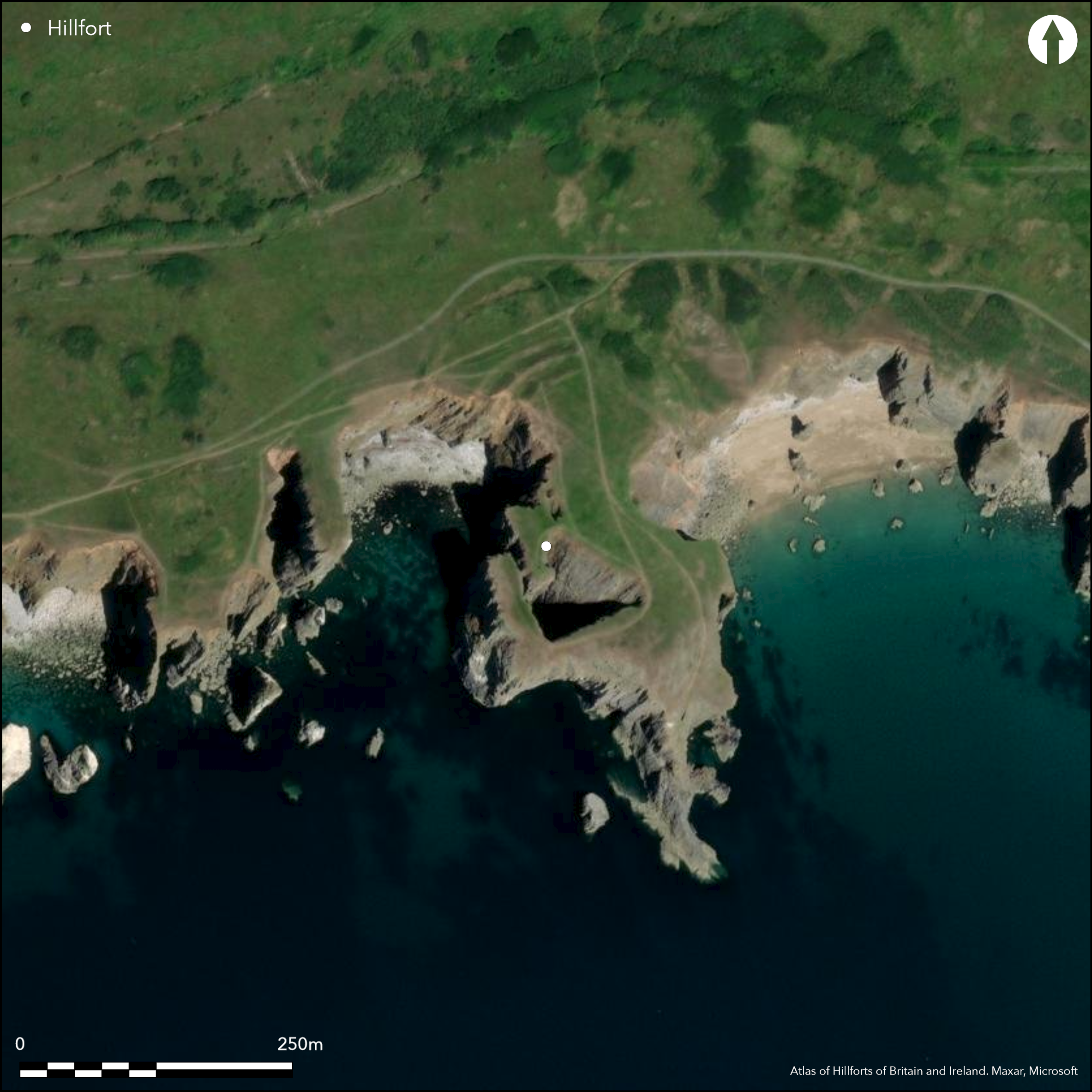
Satellite Imagery
Satellite Imagery
HER: Dyfed 602 (None)
NMR: SR 99 SW (94227)
SM: PE318(PEM)
NGR: SR 9297 9460
X: 192970 Y: 194600 (OSGB36)
Relatively large and impressive, if much eroded, coastal promontory fort sited on prominent SSE-facing limestone headland of Flimston Castles dominating S coast from The Wash to Flimston Bay, Moody Nose and Mewsford Point. S, E and W sides very steep to precipitous sea cliffs, N to landward moderate, with internal area c. 1.6ha. Good series of three curving banks and ditches, c. 120m in length, cut off the promontory on the N, but the main section is bivallate. Close-set double bank and ditch to 10m wide and 1.1m high and 10m wide and 1.1m deep respectively, sited to W of central entrance. Two scarps, to 3m high with outer ditch, 12m wide and 2.1m deep, to E of entrance, but disturbed by later quarrying. Third denuded bank, to c.1.4m high and 8m wide, with traces of outer ditch, sited c. 30m to N of the two inner ramparts, producing, in effect, an annexe, and/or indication of phased construction. This arrangement of banks is similar to Fishponds Camp, Bosherton (Atlas No 1884). Later boundary bank cuts through area. Interior contains series of geological faults, including an inset cove. Shallow scoops on sloping ground, especially on E, possible hut platforms. Later terraced road and quay on tip of promontory. Severe coastal erosion with collapsed sea caves in fort. Coastal grassland and bare rock. Within MOD Firing Range Danger Area. On 1st Ed. OS map (1865). Minimal investigations, undated.
Citizen Science: ✗
Reliability of Data: Confirmed
Reliability of Interpretation: Confirmed
X: -555665 Y: 6730276 (EPSG: 3857)
Longitude: -4.991626069615268 Latitude: 51.61202148602721 (EPSG:4326)
Country: Wales
Current County or Unitary Authority: Pembrokeshire
Historic County: Pembrokeshire
Current Parish/Community/Council/Townland: Castlemartin
Much coastal erosion. Collapsed caves resulted in vertical cliffs to sea within fort. MOD Firing Range Danger Area with notices for access times. Pembrokeshire Coastal Path just to N.
| Extant | ✓ |
| Cropmark | ✗ |
| Likely Destroyed | ✗ |
Coastal grassland and bare rock. MOD activity.
| Woodland | ✗ |
| Commercial Forestry Plantation | ✗ |
| Parkland | ✗ |
| Pasture (Grazing) | ✗ |
| Arable | ✗ |
| Scrub/Bracken | ✗ |
| Bare Outcrop | ✗ |
| Heather/Moorland | ✗ |
| Heath | ✗ |
| Built-up | ✗ |
| Coastal Grassland | ✓ |
| Other | ✓ |
Relatively large and impressive, if much eroded, coastal promontory fort sited on the prominent SSE-facing limestone headland of Flimston Castles dominating the S coast from The Wash to Flimston Bay, Moody Nose and Mewsford Point. The S, E and W sides are very steep to precipitous sea cliffs, N to landward moderate.
| Contour Fort | ✗ |
| Partial Contour Fort | ✗ |
| Promontory Fort | ✓ |
| Hillslope Fort | ✗ |
| Level Terrain Fort | ✗ |
| Marsh Fort | ✗ |
| Multiple Enclosure Fort | ✗ |
| Hilltop | ✗ |
| Coastal Promontory | ✓ |
| Inland Promontory | ✗ |
| Valley Bottom | ✗ |
| Knoll/Hillock/Outcrop | ✗ |
| Ridge | ✗ |
| Cliff/Plateau-edge/Scarp | ✗ |
| Hillslope | ✗ |
| Lowland | ✗ |
| Spur | ✗ |
Dominant Topographic Feature: Coastal headland
| North | ✗ |
| Northeast | ✗ |
| East | ✗ |
| Southeast | ✓ |
| South | ✗ |
| Southwest | ✗ |
| West | ✗ |
| Northwest | ✗ |
| Level | ✗ |
Altitude: 40.0m
N/A
No dating. Later terraced road and quay on tip of promontory.
Reliability: D - None
| Pre 1200BC | ✗ |
| 1200BC - 800BC | ✗ |
| 800BC - 400BC | ✗ |
| 400BC - AD50 | ✗ |
| AD50 - AD400 | ✗ |
| AD400 - AD 800 | ✗ |
| Post AD800 | ✗ |
| Unknown | ✓ |
| Pre Hillfort: | None |
| Post Hillfort: | Later terraced road and quay on tip of promontory. |
On 1st Ed. OS map (1865). Field Observation OS 1965. Field Observation DAT 1981, 1994, 2004. Field Observation CADW 1999, 2002. Cambria Archaeology defended enclosures survey 2006-2007. Detailed survey by RCAHMW 2009.
| 1st Identified Map Depiction (1865): | OS map. |
| Other (1965): | Field observation OS. |
| Other (2009): | RCAHMW survey. |
| Other (None): | Field observation DAT. |
| Other (None): | Field observation CADW. |
| Other (None): | Cambria Archaeology defended enclosures survey 2006-2007. |
Shallow scoops on sloping ground, especially on E, possible hut platforms.
Stream 0.2km outside fort.
| None | ✓ |
| Spring | ✗ |
| Stream | ✗ |
| Pool | ✗ |
| Flush | ✗ |
| Well | ✗ |
| Other | ✗ |
Shallow scoops on sloping ground, especially on E, possible hut platforms.
| No Known Features | ✗ |
| Round Stone Structures | ✗ |
| Rectangular Stone Structures | ✗ |
| Curvilinear Platforms | ✓ |
| Other Roundhouse Evidence | ✗ |
| Pits | ✗ |
| Quarry Hollows | ✗ |
| Other | ✗ |
None
| No Known Excavation | ✓ |
| Pits | ✗ |
| Postholes | ✗ |
| Roundhouses | ✗ |
| Rectangular Structures | ✗ |
| Roads/Tracks | ✗ |
| Quarry Hollows | ✗ |
| Other | ✗ |
| Nothing Found | ✗ |
None
| No Known Geophysics | ✓ |
| Pits | ✗ |
| Roundhouses | ✗ |
| Rectangular Structures | ✗ |
| Roads/Tracks | ✗ |
| Quarry Hollows | ✗ |
| Other | ✗ |
| Nothing Found | ✗ |
None
| No Known Finds | ✓ |
| Pottery | ✗ |
| Metal | ✗ |
| Metalworking | ✗ |
| Human Bones | ✗ |
| Animal Bones | ✗ |
| Lithics | ✗ |
| Environmental | ✗ |
| Other | ✗ |
None
| APs Not Checked | ✓ |
| None | ✗ |
| Roundhouses | ✗ |
| Rectangular Structures | ✗ |
| Pits | ✗ |
| Postholes | ✗ |
| Roads/Tracks | ✗ |
| Other | ✗ |
Central entrance to N, simple gap.
| 1: | None |
| 2: | None |
Guard Chambers: ✗
Chevaux de Frise: ✗
| 1. Simple Gap (North): | None |
Good series of three curving banks and ditches, c. 120m in length, cut off the promontory on the N, but the main defence is bivallate. Close-set double bank and ditch to 10m high and 1.1m high ands 10m wide and 1.1m deep respectively, sited to W of central entrance. Two scarps, to 3m high with outer ditch, 12m wide and 2.1m deep, to E of entrance, but disturbed by later quarrying. Third denuded bank, to c.1.4m high and 8m wide, with traces of outer ditch, sited c. 30m to N of the two inner ramparts.
| Area 1: | 1.6ha. |
| Total: | 1.6ha. |
Total Footprint Area: Noneha.
None
| ✓ | Third denuded bank, to c.1.4m high and 8m wide, with traces of outer ditch, sited c. 30m to N of the two inner ramparts, producing, in effect, an annexe, and/or indication of phased construction. |
| ✗ | Third denuded bank, to c. 1.4m high and 8m wide, with traces of outer ditch, sited c. 30m to N of the two inner ramparts, producing, in effect, an annexe, and/or indication of phased construction. Included in quadrants as annexe uncertain. |
| NE Quadrant: | 3 |
| SE Quadrant: | 0 |
| SW Quadrant: | 0 |
| NW Quadrant: | 3 |
| Total: | 3 |
| Partial Univallate | ✗ |
| Univallate | ✗ |
| Partial Bivallate | ✗ |
| Bivallate | ✗ |
| Partial Multivallate | ✓ |
| Multivallate | ✗ |
| Unknown | ✗ |
| Partial Univallate | ✗ |
| Univallate | ✗ |
| Partial Bivallate | ✗ |
| Bivallate | ✗ |
| Partial Multivallate | ✗ |
| Multivallate | ✗ |
Probable stone-walled site.
| None | ✗ |
| Earthen Bank | ✗ |
| Stone Wall | ✓ |
| Rubble | ✗ |
| Wall-walk | ✗ |
| Evidence of Timber | ✗ |
| Vitrification | ✗ |
| Other Burning | ✗ |
| Palisade | ✗ |
| Counter Scarp Bank | ✗ |
| Berm | ✗ |
| Unfinished | ✗ |
| Other | ✗ |
None
| None | ✗ |
| Earthen Bank | ✗ |
| Stone Wall | ✗ |
| Murus Duplex | ✗ |
| Timber-framed | ✗ |
| Timber-laced | ✗ |
| Vitrification | ✗ |
| Other Burning | ✗ |
| Palisade | ✗ |
| Counter Scarp Bank | ✗ |
| Berm | ✗ |
| Unfinished | ✗ |
| No Known Excavation | ✓ |
| Other | ✗ |
| ✗ | None |
| ✓ | None |
Number of Ditches: 3
| ✓ | Uncertain. Third denuded bank, to c. 1.4m high and 8m wide, with traces of outer ditch, sited c. 30m to N of the two inner ramparts, producing, in effect, an annexe, and/or indication of phased construction. |
Barker, L. and Driver, T., 2011. Close to the Edge: New Perspectives on the Architecture, Function and Regional Geographies of the Coastal Promontory Forts of the Castlemartin Peninsula, South Pembrokeshire, Wales. Proc Prehist Soc, 77, 65-87.
Crossley, D.W. 1963. List of Hill-Forts and other earthworks in Pembrokeshire, Bull Board Celtic Stud, 20, 178.
Murphy, K., Ramsey, R., Poucher, P. and Page, M. 2007. A Survey of Defended Enclosures in Pembrokeshire, 2006-2007: Gazetteer of Ordnance Survey Grid Squares SR89, SR99, SS09 and SS19, Cambria Archaeology Report No. 2007/01, Project Record No. 54269, Llandeilo: Cambria Archaeology.
Page, M., Barker, L., Driver, T. and Murphy, K. 2008. Remote sensing and the Iron Age coastal promontory forts of Pembrokeshire, Arch In Wales, 48, 27-38.
RCAMWM 1925. An inventory of the ancient monuments in Wales and Monmouthshire, VII, County of Pembroke, London: HMSO, No. 14.
Rees, S. 1992. A guide to ancient and historic Wales, London: HMSO, 80-20.
Atlas of Hillforts:
Wikidata:
This work is licensed under CC BY-SA 4.0

 and should be cited as:
Lock, Gary and Ralston, Ian. 2024. Atlas of Hillforts of Britain and Ireland. Available at: https://hillforts.arch.ox.ac.uk
Document Version 1.1