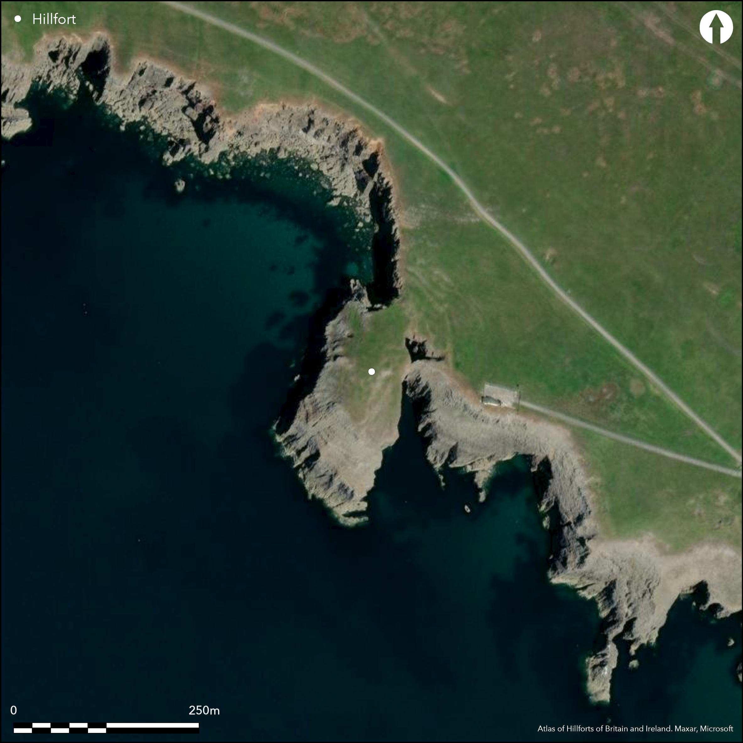
Satellite Imagery
Satellite Imagery
HER: Dyfed 609 (None)
NMR: SR 99 SE (305429)
SM: PE320(PEM)
NGR: SR 9543 9340
X: 195430 Y: 193400 (OSGB36)
Coastal promontory fort located on SSW-facing coastal headland at the base of Buckspool Down commands rocky bays and landings from Saddle Head in E to The Wash in W. Precipitous sea cliffs to E, S and W, moderate slope landward to NE. Internal area c. 0.55ha, but erosion makes assessment difficult. Curving series of three banks and ditches defend a triangular promontory, the neck of which has been severely cut into on both sides by the sea, the main bank, in effect, built on a bridge of rock joining the promontory to the mainland. Inner bank and ditch most disturbed by quarrying and partially levelled. Bank c. 30m long and c. 70m above interior. Central bank best, curving for c. 104m and between 15m and 20m from inner bank and 2m over the ditch. Simple gap entrance c. 30m from S end of the bank. Outer bank appears to define an annexe as runs from the entrance, through inner bank and then NNW, rising c. 1m above the ditch. The two outer banks are 9m and 23m from the inner bank. Some 20 terraces cut into slope possibly hut platforms and in S of the interior traces of two co-joined huts. Small Romano-British ceramic assemblage found in small excavation by Grimes (1931) but this may be later re-use. Severe coastal erosion and site only a fraction of original. Coastal grassland and bare rock. Within MOD Firing Range Danger Area. On 1st Ed. OS map (1865).
Citizen Science: ✗
Reliability of Data: Confirmed
Reliability of Interpretation: Confirmed
X: -551638 Y: 6728505 (EPSG: 3857)
Longitude: -4.955446232901131 Latitude: 51.60214555575463 (EPSG:4326)
Country: Wales
Current County or Unitary Authority: Pembrokeshire
Historic County: Pembrokeshire
Current Parish/Community/Council/Townland: Stackpole
Severe coastal erosion and quarrying disturbance. MOD Firing Range Danger Area with notices for access times. Pembrokeshire Coastal Path to NE. The neck of the headland has been severely cut into on both sides by the sea and eventually the site will become an eroding islet. Site only a fraction of original.
| Extant | ✓ |
| Cropmark | ✗ |
| Likely Destroyed | ✗ |
Coastal grassland and bare rock. Quarrying.
| Woodland | ✗ |
| Commercial Forestry Plantation | ✗ |
| Parkland | ✗ |
| Pasture (Grazing) | ✗ |
| Arable | ✗ |
| Scrub/Bracken | ✗ |
| Bare Outcrop | ✗ |
| Heather/Moorland | ✗ |
| Heath | ✗ |
| Built-up | ✗ |
| Coastal Grassland | ✓ |
| Other | ✓ |
Coastal promontory fort located on SSW-facing coastal headland at the base of Buckspool Down commands rocky bays and landings from Saddle Head in E to The Wash in W. Precipitous sea cliffs to E, S and W, moderate slope landward to NE.
| Contour Fort | ✗ |
| Partial Contour Fort | ✗ |
| Promontory Fort | ✓ |
| Hillslope Fort | ✗ |
| Level Terrain Fort | ✗ |
| Marsh Fort | ✗ |
| Multiple Enclosure Fort | ✗ |
| Hilltop | ✗ |
| Coastal Promontory | ✓ |
| Inland Promontory | ✗ |
| Valley Bottom | ✗ |
| Knoll/Hillock/Outcrop | ✗ |
| Ridge | ✗ |
| Cliff/Plateau-edge/Scarp | ✗ |
| Hillslope | ✗ |
| Lowland | ✗ |
| Spur | ✗ |
Dominant Topographic Feature: Coastal headland
| North | ✗ |
| Northeast | ✗ |
| East | ✗ |
| Southeast | ✗ |
| South | ✗ |
| Southwest | ✓ |
| West | ✗ |
| Northwest | ✗ |
| Level | ✗ |
Altitude: 35.0m
N/A
Unknown bur Grimes (1931) found small Romano-British ceramic assemblage which may be later re-use.
Reliability: D - None
| Pre 1200BC | ✗ |
| 1200BC - 800BC | ✗ |
| 800BC - 400BC | ✗ |
| 400BC - AD50 | ✗ |
| AD50 - AD400 | ✗ |
| AD400 - AD 800 | ✗ |
| Post AD800 | ✗ |
| Unknown | ✓ |
| Pre Hillfort: | None |
| Post Hillfort: | Possible later use of site? |
On 1st Ed. OS map (1865). Small excavation by W.F. Grimes in 1930?, published in 1931. Field Observation OS 1965. Field Observation DAT 1981, 1994, 2006. Field Observation CADW 1999. Cambria Archaeology defended enclosures survey 2006-2007.
| 1st Identified Map Depiction (1865): | OS map. |
| Other (1965): | Field observation OS. |
| Other (1999): | Field observation CADW. |
| Excavation (None): | W.F. Grimes |
| Other (None): | Field observation DAT. |
| Other (None): | Cambria Archaeology defended enclosures survey. |
Some 20 terraces cut into slope possibly hut platforms and in S of the interior traces of two co-joined huts. Small Romano-British ceramic assemblage found by Grimes (1931).
Spring 0.65km outside fort.
| None | ✓ |
| Spring | ✗ |
| Stream | ✗ |
| Pool | ✗ |
| Flush | ✗ |
| Well | ✗ |
| Other | ✗ |
Some 20 terraces cut into slope possibly hut platforms and in S of the interior traces of two co-joined huts.
| No Known Features | ✗ |
| Round Stone Structures | ✗ |
| Rectangular Stone Structures | ✗ |
| Curvilinear Platforms | ✓ |
| Other Roundhouse Evidence | ✗ |
| Pits | ✗ |
| Quarry Hollows | ✗ |
| Other | ✗ |
Evidence of occupation.
| No Known Excavation | ✗ |
| Pits | ✗ |
| Postholes | ✗ |
| Roundhouses | ✗ |
| Rectangular Structures | ✗ |
| Roads/Tracks | ✗ |
| Quarry Hollows | ✗ |
| Other | ✓ |
| Nothing Found | ✗ |
None
| No Known Geophysics | ✓ |
| Pits | ✗ |
| Roundhouses | ✗ |
| Rectangular Structures | ✗ |
| Roads/Tracks | ✗ |
| Quarry Hollows | ✗ |
| Other | ✗ |
| Nothing Found | ✗ |
Small Romano-British ceramic assemblage found by Grimes (1931).
| No Known Finds | ✗ |
| Pottery | ✓ |
| Metal | ✗ |
| Metalworking | ✗ |
| Human Bones | ✗ |
| Animal Bones | ✗ |
| Lithics | ✗ |
| Environmental | ✗ |
| Other | ✗ |
None
| APs Not Checked | ✓ |
| None | ✗ |
| Roundhouses | ✗ |
| Rectangular Structures | ✗ |
| Pits | ✗ |
| Postholes | ✗ |
| Roads/Tracks | ✗ |
| Other | ✗ |
Simple gap entrance c. 30m from S end of the bank.
| 1: | None |
| 2: | None |
Guard Chambers: ✗
Chevaux de Frise: ✗
| 1. Simple Gap (North east): | None |
Curving series of three banks and ditches defend a triangular promontory, the neck of which has been severely cut into on both sides by the sea, the main bank in effect built on a bridge of rock joining the promontory to the mainland. Inner bank and ditch most disturbed by quarrying and partially levelled. Bank c. 30m long and c. 70m above interior. Central bank best, curving for c. 104m and between 15m and 20m from inner bank and 2m over the ditch. Simple gap entrance c. 30m from S end of the bank.
| Area 1: | 0.55ha. |
| Total: | 0.55ha. |
Total Footprint Area: Noneha.
None
| ✗ | Internal area c. 0.55ha, but erosion makes assessment difficult. |
| ✗ | Outer bank appears to define an annexe as runs from the entrance, through inner bank and then NNW. Uncertain and included in quadrants. |
| NE Quadrant: | 3 |
| SE Quadrant: | 0 |
| SW Quadrant: | 0 |
| NW Quadrant: | 0 |
| Total: | 3 |
| Partial Univallate | ✗ |
| Univallate | ✗ |
| Partial Bivallate | ✗ |
| Bivallate | ✗ |
| Partial Multivallate | ✓ |
| Multivallate | ✗ |
| Unknown | ✗ |
| Partial Univallate | ✗ |
| Univallate | ✗ |
| Partial Bivallate | ✗ |
| Bivallate | ✗ |
| Partial Multivallate | ✗ |
| Multivallate | ✗ |
Probable stone-walled site.
| None | ✗ |
| Earthen Bank | ✗ |
| Stone Wall | ✓ |
| Rubble | ✗ |
| Wall-walk | ✗ |
| Evidence of Timber | ✗ |
| Vitrification | ✗ |
| Other Burning | ✗ |
| Palisade | ✗ |
| Counter Scarp Bank | ✗ |
| Berm | ✗ |
| Unfinished | ✗ |
| Other | ✗ |
None
| None | ✓ |
| Earthen Bank | ✗ |
| Stone Wall | ✗ |
| Murus Duplex | ✗ |
| Timber-framed | ✗ |
| Timber-laced | ✗ |
| Vitrification | ✗ |
| Other Burning | ✗ |
| Palisade | ✗ |
| Counter Scarp Bank | ✗ |
| Berm | ✗ |
| Unfinished | ✗ |
| No Known Excavation | ✗ |
| Other | ✗ |
| ✗ | None |
| ✓ | None |
Number of Ditches: 3
| ✓ | Outer bank appears to define an annexe as runs from the entrance, through inner bank and then NNW. |
Barker, L. and Driver, T., 2011. Close to the Edge: New Perspectives on the Architecture, Function and Regional Geographies of the Coastal Promontory Forts of the Castlemartin Peninsula, South Pembrokeshire, Wales. Proc Prehist Soc, 77, 65-87.
Crossley, D.W. 1963. List of Hill-Forts and other earthworks in Pembrokeshire, Bull Board Celtic Stud, 20, 179.
Grimes, W.F. 1931. Roman-British pottery from Crocksydam Camp, Warren , Pemb., Bull Board Celtic Stud, 5, 394-5.
Murphy, K., Ramsey, R., Poucher, P. and Page, M. 2007. A Survey of Defended Enclosures in Pembrokeshire, 2006-2007: Gazetteer of Ordnance Survey Grid Squares SR89, SR99, SS09 and SS19, Cambria Archaeology Report No. 2007/01, Project Record No. 54269, Llandeilo: Cambria Archaeology.
RCAMWM 1925. An inventory of the ancient monuments in Wales and Monmouthshire, VII, County of Pembroke, London: HMSO, No. 47.
Rees, S. 1992. A guide to ancient and historic Wales - Dyfed, London: HMSO, 81.
Atlas of Hillforts:
Wikidata:
This work is licensed under CC BY-SA 4.0

 and should be cited as:
Lock, Gary and Ralston, Ian. 2024. Atlas of Hillforts of Britain and Ireland. Available at: https://hillforts.arch.ox.ac.uk
Document Version 1.1