
LiDAR 1m DTM Hillshade
Satellite Imagery
LiDAR 1m DTM Hillshade
Satellite Imagery
Scroll left/right to view further images.
HER: Dyfed 920 (None)
NMR: SN 12 SW (304294)
SM: PE225(PEM)
NGR: SN 1100 2175
X: 211000 Y: 221750 (OSGB36)
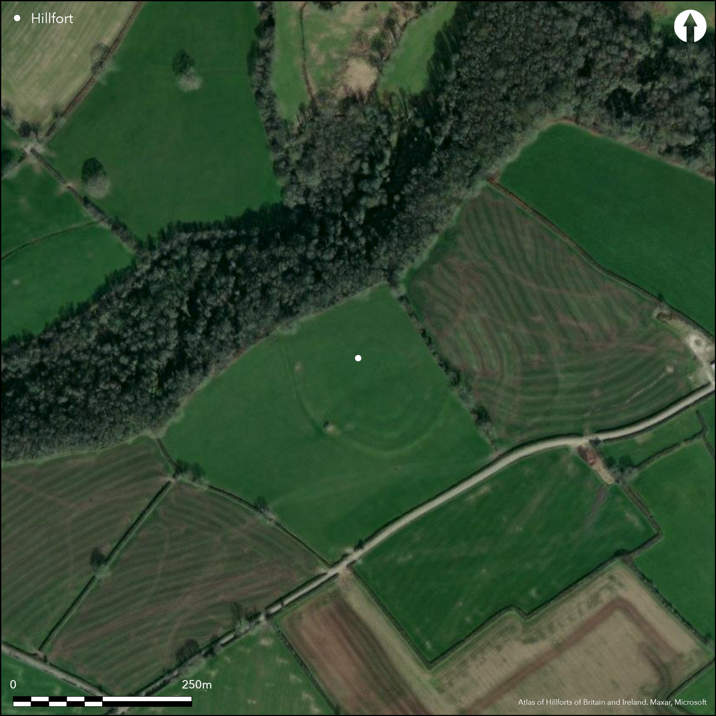
Multiple enclosure fort sited on a SW-facing ridge-top spur, above a sharp bend of the Eastern Cleddau. Steep surrounding slopes to N and W, moderate to E and S. Castell Gwyn II (Atlas No. 2101) nearby to WSW. Site overall c. 140m - 150m across, with interior bivallate enclosure c. 55m NNW-SSE by 30m internally, set within horseshoe-shaped outer enclosure. N straight side falls c. 50m below scarp edge to wooded valley below forming natural defence. Inner enclosure defined by two ploughed banks and ditches on its S side, with only one bank and ditch around entire circuit. Simple SW entrance. Rampart of outer horseshoe-shaped enclosure close to S side of inner enclosure, forming, in effect, a multivallate enclosuree for the entire site, but elsewhere it diverges. On W of this outer circuit bank best and to 2m high above ditch bottom, with good counterscarp. On E side defences overlain and affected by hedge-line. Also with simple SW entrance. Possibly phased construction but undated. Under improved pasture apart from hedge on E. On 1st Ed. OS map (1889).
Citizen Science: ✗
Reliability of Data: Confirmed
Reliability of Interpretation: Confirmed
X: -528356 Y: 6775248 (EPSG: 3857)
Longitude: -4.746299323998755 Latitude: 51.86219962274139 (EPSG:4326)
Country: Wales
Current County or Unitary Authority: Pembrokeshire
Historic County: Pembrokeshire
Current Parish/Community/Council/Townland: Llandissilio West
Fair condition. Affected by hedgeline on E side.
| Extant | ✓ |
| Cropmark | ✗ |
| Likely Destroyed | ✗ |
Under pasture. Wooded slopes to N.
| Woodland | ✗ |
| Commercial Forestry Plantation | ✗ |
| Parkland | ✗ |
| Pasture (Grazing) | ✓ |
| Arable | ✗ |
| Scrub/Bracken | ✗ |
| Bare Outcrop | ✗ |
| Heather/Moorland | ✗ |
| Heath | ✗ |
| Built-up | ✗ |
| Coastal Grassland | ✗ |
| Other | ✗ |
Multiple enclosure fort sited on a SW-facing ridge-top spur, above a sharp bend of the Eastern Cleddau. Steep surrounding slopes to N and W, moderate to E and S.
| Contour Fort | ✗ |
| Partial Contour Fort | ✗ |
| Promontory Fort | ✗ |
| Hillslope Fort | ✗ |
| Level Terrain Fort | ✗ |
| Marsh Fort | ✗ |
| Multiple Enclosure Fort | ✓ |
| Hilltop | ✗ |
| Coastal Promontory | ✗ |
| Inland Promontory | ✗ |
| Valley Bottom | ✗ |
| Knoll/Hillock/Outcrop | ✗ |
| Ridge | ✗ |
| Cliff/Plateau-edge/Scarp | ✓ |
| Hillslope | ✗ |
| Lowland | ✗ |
| Spur | ✗ |
Dominant Topographic Feature: Scarp edge
| North | ✗ |
| Northeast | ✗ |
| East | ✗ |
| Southeast | ✗ |
| South | ✗ |
| Southwest | ✓ |
| West | ✗ |
| Northwest | ✗ |
| Level | ✗ |
Altitude: 91.0m
N/A
None
Reliability: D - None
| Pre 1200BC | ✗ |
| 1200BC - 800BC | ✗ |
| 800BC - 400BC | ✗ |
| 400BC - AD50 | ✗ |
| AD50 - AD400 | ✗ |
| AD400 - AD 800 | ✗ |
| Post AD800 | ✗ |
| Unknown | ✓ |
| Pre Hillfort: | None |
| Post Hillfort: | None |
On 1st Ed. OS map (1889). Field Observation OS 1975. Field Observation DAT 1981, 1986. Field Observation CADW 1991, 2002. Cambria Archaeology defended enclosures survey 2006-2007.
| 1st Identified Map Depiction (1889): | OS map. |
| Other (1975): | Field observation OS. |
| Other (None): | Field observation DAT. |
| Other (None): | Field observation CADW. |
| Other (None): | Cambria Archaeology defended enclosures survey. |
None
Eastern Cleddau 0.1 km outside fort.
| None | ✓ |
| Spring | ✗ |
| Stream | ✗ |
| Pool | ✗ |
| Flush | ✗ |
| Well | ✗ |
| Other | ✗ |
None
| No Known Features | ✓ |
| Round Stone Structures | ✗ |
| Rectangular Stone Structures | ✗ |
| Curvilinear Platforms | ✗ |
| Other Roundhouse Evidence | ✗ |
| Pits | ✗ |
| Quarry Hollows | ✗ |
| Other | ✗ |
None
| No Known Excavation | ✓ |
| Pits | ✗ |
| Postholes | ✗ |
| Roundhouses | ✗ |
| Rectangular Structures | ✗ |
| Roads/Tracks | ✗ |
| Quarry Hollows | ✗ |
| Other | ✗ |
| Nothing Found | ✗ |
None
| No Known Geophysics | ✓ |
| Pits | ✗ |
| Roundhouses | ✗ |
| Rectangular Structures | ✗ |
| Roads/Tracks | ✗ |
| Quarry Hollows | ✗ |
| Other | ✗ |
| Nothing Found | ✗ |
None
| No Known Finds | ✓ |
| Pottery | ✗ |
| Metal | ✗ |
| Metalworking | ✗ |
| Human Bones | ✗ |
| Animal Bones | ✗ |
| Lithics | ✗ |
| Environmental | ✗ |
| Other | ✗ |
None
| APs Not Checked | ✓ |
| None | ✗ |
| Roundhouses | ✗ |
| Rectangular Structures | ✗ |
| Pits | ✗ |
| Postholes | ✗ |
| Roads/Tracks | ✗ |
| Other | ✗ |
Simple gap entrances on SW to both inner and outer enclosures.
| 2: | None |
| 2: | None |
Guard Chambers: ✗
Chevaux de Frise: ✗
| 1. Simple Gap (South west): | Inner enclosure entrance. |
| 2. Simple Gap (South west): | Outer enclosure entrance. |
Inner enclosure defined by two ploughed banks and ditches on its S side, with only one bank and ditch around entire circuit. Rampart of outer horseshoe-shaped enclosure close to S side of inner enclosure, forming, in effect, a multivallate defence for the entire site, but elsewhere it diverges. On W of this outer circuit bank best and to 2m high above ditch bottom, with good counterscarp.
| Area 1: | 0.94ha. |
| Total: | 0.94ha. |
Total Footprint Area: Noneha.
None
| ✓ | Morphology suggests phased construction, but no details. |
| ✓ | None |
| NE Quadrant: | 2 |
| SE Quadrant: | 3 |
| SW Quadrant: | 3 |
| NW Quadrant: | 2 |
| Total: | 3 |
| Partial Univallate | ✗ |
| Univallate | ✗ |
| Partial Bivallate | ✓ |
| Bivallate | ✗ |
| Partial Multivallate | ✓ |
| Multivallate | ✗ |
| Unknown | ✗ |
| Partial Univallate | ✗ |
| Univallate | ✗ |
| Partial Bivallate | ✗ |
| Bivallate | ✗ |
| Partial Multivallate | ✗ |
| Multivallate | ✗ |
Counterscarp to outer rampart.
| None | ✗ |
| Earthen Bank | ✓ |
| Stone Wall | ✗ |
| Rubble | ✗ |
| Wall-walk | ✗ |
| Evidence of Timber | ✗ |
| Vitrification | ✗ |
| Other Burning | ✗ |
| Palisade | ✗ |
| Counter Scarp Bank | ✓ |
| Berm | ✗ |
| Unfinished | ✗ |
| Other | ✗ |
None
| None | ✗ |
| Earthen Bank | ✗ |
| Stone Wall | ✗ |
| Murus Duplex | ✗ |
| Timber-framed | ✗ |
| Timber-laced | ✗ |
| Vitrification | ✗ |
| Other Burning | ✗ |
| Palisade | ✗ |
| Counter Scarp Bank | ✗ |
| Berm | ✗ |
| Unfinished | ✗ |
| No Known Excavation | ✓ |
| Other | ✗ |
| ✗ | None |
| ✓ | Two ditches to inner enclosure, one to outer. |
Number of Ditches: 3
| ✗ | None |
Crossley, D.W. 1963. List of Hill-Forts and other earthworks in Pembrokeshire, Bull Board Celtic Stud, 20, 190.
Murphy, K., Ramsey, R., Poucher, P. and Page, M. 2007. A Survey of Defended Enclosures in Pembrokeshire, 2006-2007: Gazetteer of Ordnance Survey Grid Squares SN10, SN11 and SN12. Cambria Archaeology Report No. 2007/01, Project Record No. 54269, Llandeilo: Cambria Archaeology.
RCAMWM 1925. An inventory of the ancient monuments in Wales and Monmouthshire, VII, County of Pembroke, London: HMSO, No. 446.
Atlas of Hillforts:
Wikidata:
This work is licensed under CC BY-SA 4.0![]()
![]()
![]() and should be cited as:
and should be cited as:
Lock, Gary and Ralston, Ian. 2024. Atlas of Hillforts of Britain and Ireland. Available at: https://hillforts.arch.ox.ac.uk
Document Version 1.1