LiDAR 1m DTM Hillshade

Satellite Imagery
LiDAR 1m DTM Hillshade
Satellite Imagery
Scroll left/right to view further images.
HER: Dyfed 983 (None)
NMR: SN 13 NW (304047)
SM: PE172(PEM)
NGR: SN 1188 3778
X: 211880 Y: 237780 (OSGB36)
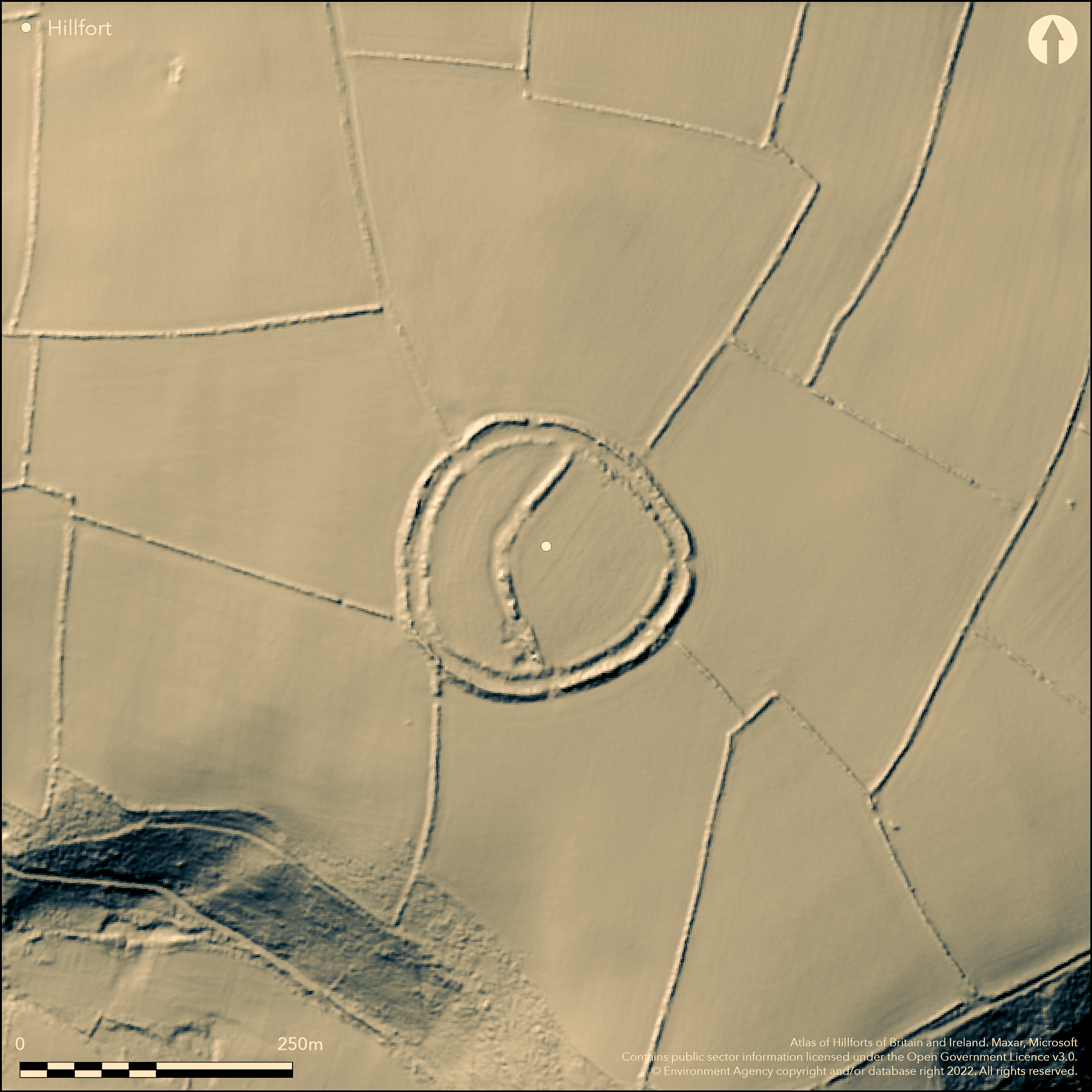
Larger sized for the area bivallate contour hillfort located on rounded summit of hill above the Afon Nyfer opposite its confluence with the Afon Brynberian. Moderate to strong surrounding slopes on N, E and W, steep on S. Survey, geophysical survey and excavation in 2012 by M. Parker-Pearson linked to possible Neolithic origins of the hillfort and possible earlier ritual or ceremonial henge enclosure reused in the Iron Age (no further details). Oval in shape measuring c. 130m SE-NW by 130m, with internal area 1.52ha. An inner bank rises to 2m above a wide shallow ditch, with the outer bank to over 3m exterior and dominating the inner bank in places. Outer ditch nearly ploughed out. Field bank runs along outer bank's crest. Interior divided into two fields by curving rampart NE-S to 2m high on W, with shallow ditch. Simple gap entrance on E, with modern gap on SE side and breach through outer bank on N. Remains of hut possibly in SW corner where there is a depression. Pasture interior, scrub on banks. On 1st Ed. OS map (1889). Undated.
Citizen Science: ✗
Reliability of Data: Confirmed
Reliability of Interpretation: Confirmed
X: -527911 Y: 6801293 (EPSG: 3857)
Longitude: -4.742303211576497 Latitude: 52.00645783486396 (EPSG:4326)
Country: Wales
Current County or Unitary Authority: Pembrokeshire
Historic County: Pembrokeshire
Current Parish/Community/Council/Townland: Eglwyswrw
Interior divided into two fields by curving rampart NE-S.
| Extant | ✓ |
| Cropmark | ✗ |
| Likely Destroyed | ✗ |
Pasture interior, scrub on banks.
| Woodland | ✗ |
| Commercial Forestry Plantation | ✗ |
| Parkland | ✗ |
| Pasture (Grazing) | ✓ |
| Arable | ✗ |
| Scrub/Bracken | ✓ |
| Bare Outcrop | ✗ |
| Heather/Moorland | ✗ |
| Heath | ✗ |
| Built-up | ✗ |
| Coastal Grassland | ✗ |
| Other | ✗ |
Larger sized for the area bivallate contour hillfort located on rounded summit of hill above the Afon Nyfer opposite its confluence with the Afon Brynberian. Moderate to strong surrounding slopes on N, E and W, steep on S.
| Contour Fort | ✓ |
| Partial Contour Fort | ✗ |
| Promontory Fort | ✗ |
| Hillslope Fort | ✗ |
| Level Terrain Fort | ✗ |
| Marsh Fort | ✗ |
| Multiple Enclosure Fort | ✗ |
| Hilltop | ✓ |
| Coastal Promontory | ✗ |
| Inland Promontory | ✗ |
| Valley Bottom | ✗ |
| Knoll/Hillock/Outcrop | ✗ |
| Ridge | ✗ |
| Cliff/Plateau-edge/Scarp | ✗ |
| Hillslope | ✗ |
| Lowland | ✗ |
| Spur | ✗ |
Dominant Topographic Feature: Hill top
| North | ✗ |
| Northeast | ✗ |
| East | ✗ |
| Southeast | ✗ |
| South | ✗ |
| Southwest | ✗ |
| West | ✗ |
| Northwest | ✗ |
| Level | ✓ |
Altitude: 140.0m
N/A
None
Reliability: D - None
| Pre 1200BC | ✗ |
| 1200BC - 800BC | ✗ |
| 800BC - 400BC | ✗ |
| 400BC - AD50 | ✗ |
| AD50 - AD400 | ✗ |
| AD400 - AD 800 | ✗ |
| Post AD800 | ✗ |
| Unknown | ✓ |
| Pre Hillfort: | Possible earlier ritual or ceremonial henge enclosure reused in the Iron Age. |
| Post Hillfort: | None |
On 1st Ed. OS map (1889). Full Survey G.H. Williams 1969. Field Observation OS 1974. Field Observation C.M. Stenger 1979. Field Observation DAT 1981. Partial geophysical survey in 1988. Field Observation CADW 1996. Cambria Archaeology defended enclosures survey 2006-2007. Survey, geophysical survey and excavation at the site in 2012 by Prof. Mike Parker-Pearson linked to possible Neolithic origins of the hillfort/henge and ongoing work at Craig Rhosyfelin quarry - no further details.
| 1st Identified Map Depiction (1889): | OS map. |
| Other (1969): | Full Survey G.H. Williams. |
| Other (1973): | Visited by Hillfort Study Group |
| Other (1974): | Field Observation OS. |
| Other (1979): | Field Observation C.M. Stenger. |
| Other (1981): | Field observation DAT. |
| Other (1996): | Field observation CADW. |
| Excavation (2012): | M Parker-Pearson geophysical survey and excavation. |
| Other (None): | Cambria Archaeology defended enclosures survey |
Remains of hut possibly in SW corner where there is a depression. Tanged iron spearhead was found in the field to S. No details of geophysics and excavation.
Afon Nyfer 0.35 km outside fort.
| None | ✓ |
| Spring | ✗ |
| Stream | ✗ |
| Pool | ✗ |
| Flush | ✗ |
| Well | ✗ |
| Other | ✗ |
Remains of hut possibly in SW corner where there is a depression.
| No Known Features | ✗ |
| Round Stone Structures | ✗ |
| Rectangular Stone Structures | ✗ |
| Curvilinear Platforms | ✗ |
| Other Roundhouse Evidence | ✗ |
| Pits | ✗ |
| Quarry Hollows | ✗ |
| Other | ✓ |
No details of excavation.
| No Known Excavation | ✗ |
| Pits | ✗ |
| Postholes | ✗ |
| Roundhouses | ✗ |
| Rectangular Structures | ✗ |
| Roads/Tracks | ✗ |
| Quarry Hollows | ✗ |
| Other | ✓ |
| Nothing Found | ✗ |
No details of surveys.
| No Known Geophysics | ✗ |
| Pits | ✗ |
| Roundhouses | ✗ |
| Rectangular Structures | ✗ |
| Roads/Tracks | ✗ |
| Quarry Hollows | ✗ |
| Other | ✓ |
| Nothing Found | ✗ |
Tanged iron spearhead was found in the field to S.
| No Known Finds | ✓ |
| Pottery | ✗ |
| Metal | ✗ |
| Metalworking | ✗ |
| Human Bones | ✗ |
| Animal Bones | ✗ |
| Lithics | ✗ |
| Environmental | ✗ |
| Other | ✗ |
None
| APs Not Checked | ✓ |
| None | ✗ |
| Roundhouses | ✗ |
| Rectangular Structures | ✗ |
| Pits | ✗ |
| Postholes | ✗ |
| Roads/Tracks | ✗ |
| Other | ✗ |
Simple gap entrance on E, with modern gap on SE side and breach through outer bank on N.
| 3: | Modern gap on SE side and breach through outer bank on N. |
| 2: | None |
Guard Chambers: ✗
Chevaux de Frise: ✗
| 1. Simple Gap (East): | None |
An inner bank rises to 2m above a wide shallow ditch, with the outer bank to over 3m exterior and dominating the inner bank in places. Outer ditch nearly ploughed out. Field bank runs along outer bank's crest. Interior divided into two fields by curving rampart NE-S to 2m high on W, with shallow ditch.
| Area 1: | 1.52ha. |
| Total: | 1.52ha. |
Total Footprint Area: Noneha.
None
| ✓ | Possibly two phased. |
| ✓ | None |
| NE Quadrant: | 2 |
| SE Quadrant: | 2 |
| SW Quadrant: | 2 |
| NW Quadrant: | 2 |
| Total: | 2 |
| Partial Univallate | ✗ |
| Univallate | ✗ |
| Partial Bivallate | ✗ |
| Bivallate | ✓ |
| Partial Multivallate | ✗ |
| Multivallate | ✗ |
| Unknown | ✗ |
| Partial Univallate | ✗ |
| Univallate | ✓ |
| Partial Bivallate | ✗ |
| Bivallate | ✗ |
| Partial Multivallate | ✗ |
| Multivallate | ✗ |
None
| None | ✗ |
| Earthen Bank | ✓ |
| Stone Wall | ✗ |
| Rubble | ✗ |
| Wall-walk | ✗ |
| Evidence of Timber | ✗ |
| Vitrification | ✗ |
| Other Burning | ✗ |
| Palisade | ✗ |
| Counter Scarp Bank | ✗ |
| Berm | ✗ |
| Unfinished | ✗ |
| Other | ✗ |
No details.
| None | ✗ |
| Earthen Bank | ✗ |
| Stone Wall | ✗ |
| Murus Duplex | ✗ |
| Timber-framed | ✗ |
| Timber-laced | ✗ |
| Vitrification | ✗ |
| Other Burning | ✗ |
| Palisade | ✗ |
| Counter Scarp Bank | ✗ |
| Berm | ✗ |
| Unfinished | ✗ |
| No Known Excavation | ✗ |
| Other | ✓ |
| ✗ | None |
| ✓ | Outer ditch nearly ploughed out. |
Number of Ditches: 2
| ✗ | None |
Crossley, D.W. 1963. List of Hill-Forts and other earthworks in Pembrokeshire, Bull Board Celtic Stud, 20, 189.
Murphy, K., Ramsey, R., Poucher, P. and Page, M. 2007. A Survey of Defended Enclosures in Pembrokeshire, 2006-2007: Gazetteer of Ordnance Survey Grid Squares SN03, SN13 and SN23. Cambria Archaeology Report No. 2007/01, Project Record No. 54269, Llandeilo: Cambria Archaeology.
RCAMWM 1925. An inventory of the ancient monuments in Wales and Monmouthshire, VII, County of Pembroke, London: HMSO, No. 684.
Atlas of Hillforts:
Wikidata:
This work is licensed under CC BY-SA 4.0![]()
![]()
![]() and should be cited as:
and should be cited as:
Lock, Gary and Ralston, Ian. 2024. Atlas of Hillforts of Britain and Ireland. Available at: https://hillforts.arch.ox.ac.uk
Document Version 1.1