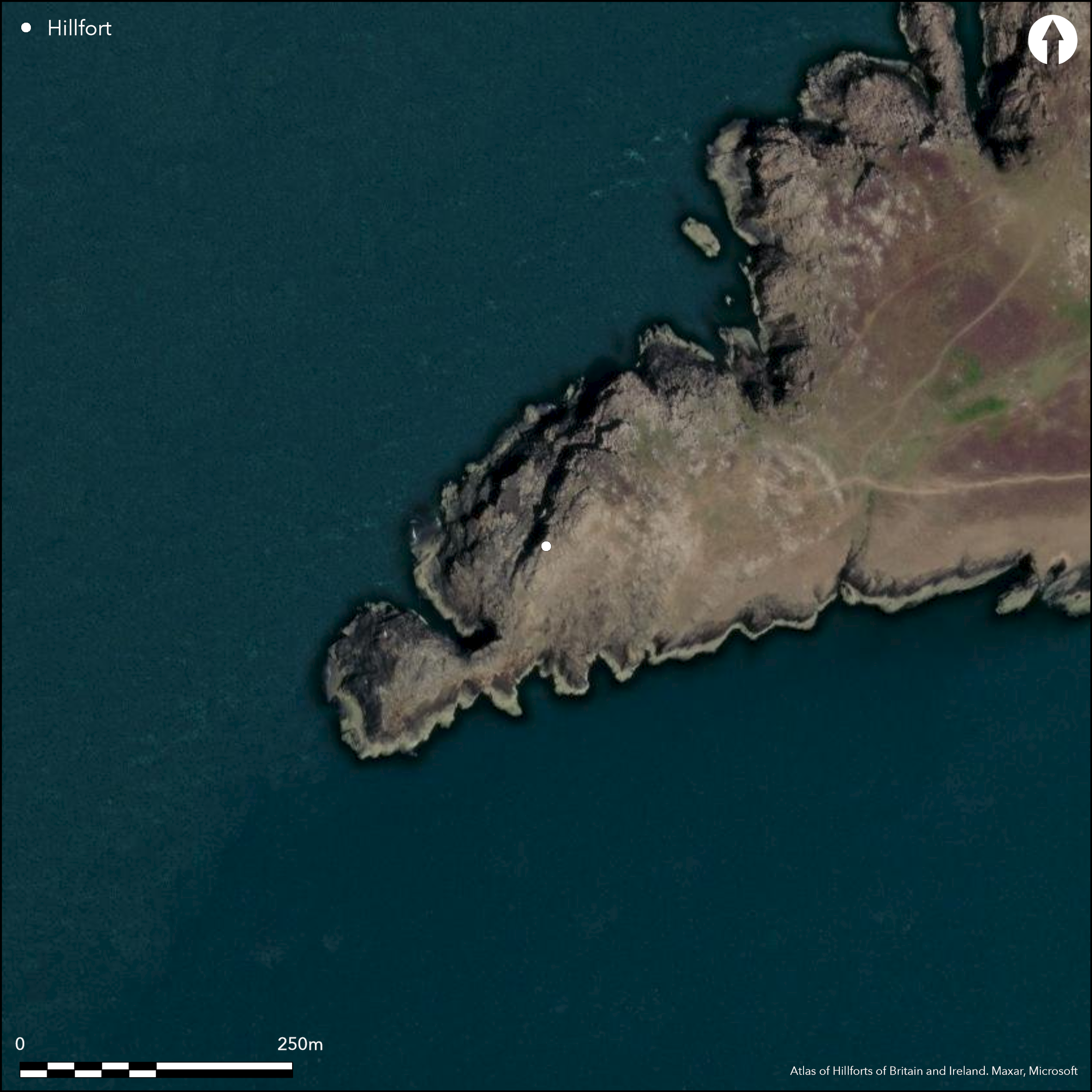
Satellite Imagery
Satellite Imagery
HER: Dyfed 2624 (None)
NMR: SM 72 NW (94974)
SM: PE071(PEM)
NGR: SM 7220 2790
X: 172200 Y: 227900 (OSGB36)
Fine, and very exposed, coastal promontory fort sited on sinuous SW-facing rocky promontory, 200m E-W by 130m, jutting into Irish Sea and dominating Whitesands Bay to S. Steep rocky slopes to N, S and W, gradual rising slope landward to NE. Possible phased construction. Promontory cut off on the NE by multiple stone-walled system, lying on W side of shallow saddle. Within interior to W is massive outcrop of bare rock. Massive inner spread-rubble former stone wall and outer ditch runs for c. 100m, with bare stone exposed on E, with maximum of 3m high from base of ditch and c.10m wide. Ditch c. 4m wide and 0.5m deep. Wall-faces of three to four courses of dry-stone masonry visible towards the N end of exterior. Two slighter walls with ditches lie outside this main defence. Inner is of earth stone bank, to 1m high and 4m wide with no ditch, and may be a counterscarp or some other component of the defences. Third bank lies 4m -5m from it and probably part of the defences as boulders curve inwards to form an entrance passageway. This is 2.1m wide with bare stone exposed and extends through the walls. Seven or eight fine stone hut foundations of roundhouses, cut as terraces, 8m to 9.8m diameter with 1m thick walls and simple gap entrances and central hearths, are visible on the SE side, where is only space (at c. 50m by 30m) available for occupation - remainder bare rock, washed by the sea on SW. Historic excavation in 1898 by Rev. Baring Gould investigated seven of the roundhouses and found spindle whorls, blue glass beads, stone, flints and pottery, all of late Iron Age/Romano-British date, now in Tenby Museum. A new survey by Cambria Archaeology with aerial reconnaissance by RCAHMW and Chris Musson identified another massive wall built inland of the fort cutting off c. 25 ha of W headland and following key contours, with also a central gateway. Suggested as an outer defence for Clawdd y Milwyr (Driver, T. 2007, 95-98). Field systems outside fort to E probably contemporaneous. Rocky coastal grassland. A classic and important site. On 1st Ed. OS map (1889).
Citizen Science: ✗
Reliability of Data: Confirmed
Reliability of Interpretation: Confirmed
X: -591433 Y: 6782590 (EPSG: 3857)
Longitude: -5.312928910161134 Latitude: 51.90291162573353 (EPSG:4326)
Country: Wales
Current County or Unitary Authority: Pembrokeshire
Historic County: Pembrokeshire
Current Parish/Community/Council/Townland: St Davids and the Cathedral Close St David's
Rubble walls dispersed and coastal erosion, but generally good. Pembrokeshire Coast Path just to NE.
| Extant | ✓ |
| Cropmark | ✗ |
| Likely Destroyed | ✗ |
Rocky coastal grassland.
| Woodland | ✗ |
| Commercial Forestry Plantation | ✗ |
| Parkland | ✗ |
| Pasture (Grazing) | ✗ |
| Arable | ✗ |
| Scrub/Bracken | ✗ |
| Bare Outcrop | ✗ |
| Heather/Moorland | ✗ |
| Heath | ✗ |
| Built-up | ✗ |
| Coastal Grassland | ✓ |
| Other | ✗ |
Fine coastal promontory fort sited on sinuous SW-facing rocky promontory jutting into Irish Sea and dominating Whitesands Bay to S. Steep rocky slopes to N, S and W, gentle slope landward to NE.
| Contour Fort | ✗ |
| Partial Contour Fort | ✗ |
| Promontory Fort | ✓ |
| Hillslope Fort | ✗ |
| Level Terrain Fort | ✗ |
| Marsh Fort | ✗ |
| Multiple Enclosure Fort | ✗ |
| Hilltop | ✗ |
| Coastal Promontory | ✓ |
| Inland Promontory | ✗ |
| Valley Bottom | ✗ |
| Knoll/Hillock/Outcrop | ✗ |
| Ridge | ✗ |
| Cliff/Plateau-edge/Scarp | ✗ |
| Hillslope | ✗ |
| Lowland | ✗ |
| Spur | ✗ |
Dominant Topographic Feature: Coastal Headland
| North | ✗ |
| Northeast | ✗ |
| East | ✗ |
| Southeast | ✗ |
| South | ✗ |
| Southwest | ✓ |
| West | ✗ |
| Northwest | ✗ |
| Level | ✗ |
Altitude: 35.0m
N/A
Excavation found spindle whorls, blue glass beads, stone, flints and pottery, all of late Iron Age Romano-British date, but site probably much earlier and could have late Bronze Age origins or even the Neolithic.
Reliability: B - Medium
| Pre 1200BC | ✗ |
| 1200BC - 800BC | ✗ |
| 800BC - 400BC | ✓ |
| 400BC - AD50 | ✓ |
| AD50 - AD400 | ✗ |
| AD400 - AD 800 | ✗ |
| Post AD800 | ✗ |
| Unknown | ✗ |
| Pre Hillfort: | None |
| Post Hillfort: | None |
| Artefactual: | Excavation found spindle whorls, blue glass beads, stone, flints and pottery, all of Romano-British date. |
George Owen description c. 1600. Sir Richard Colt Hoare description 1793. Richard Fenton description in tour of Pembrokeshire 1811. On 1st Ed. OS map (1889). Part excavation Rev. S. Baring-Gould et al 1898. Field Observation OS 1973. Field Obsveration AMB 1981. Field Obsrvation NT 1986. Field Observation DAT 1994, 1997, 2006. Field Observation CADW 1998. Cambria Archaeology defended enclosures survey 2006-2007. LiDAR and topographic survey (Page et al 2008).
| Other (1793): | Sir Richard Colt Hoare. |
| Other (1811): | Fenton description in tour of Pembrokeshire. |
| 1st Identified Map Depiction (1889): | OS map. |
| Excavation (1898): | Part excavation Rev. Baring-Gould et al. |
| Other (1973): | Field observation OS. |
| Other (1973): | Visited by Hillfort Study Group |
| Other (1981): | Field observation AMB. |
| Other (1986): | Field observation NT. |
| Other (1998): | Field observation CADW. |
| LiDAR Survey (2008): | None |
| Other (2011): | Visited by Hillfort Study Group |
| Other (None): | Field observation DAT. |
| Other (None): | Cambria Archaeology defended enclosures survey |
| 1st Identified Written Reference (None): | George Owen. |
Seven or eight fine stone hut foundations of roundhouses, cut as terraces, 8m to 9.8m diameter with 1m thick walls and simple gap entrances and central hearths, are visible on the SE side, where is only space (at c. 50m by 30m) available for occupation. Spindle whorls, glass beads, flints and pottery.
None
| None | ✓ |
| Spring | ✗ |
| Stream | ✗ |
| Pool | ✗ |
| Flush | ✗ |
| Well | ✗ |
| Other | ✗ |
Seven or eight fine stone hut foundations of roundhouses, cut as terraces or platforms, 8m to 9.8m diameter with 1m thick walls and simple gap entrances and central hearths, are visible on the SE side.
| No Known Features | ✗ |
| Round Stone Structures | ✓ |
| Rectangular Stone Structures | ✗ |
| Curvilinear Platforms | ✓ |
| Other Roundhouse Evidence | ✗ |
| Pits | ✗ |
| Quarry Hollows | ✗ |
| Other | ✓ |
Excavation in 1898 by Rev. Baring Gould investigated seven of the roundhouses.
| No Known Excavation | ✗ |
| Pits | ✗ |
| Postholes | ✗ |
| Roundhouses | ✓ |
| Rectangular Structures | ✗ |
| Roads/Tracks | ✗ |
| Quarry Hollows | ✗ |
| Other | ✗ |
| Nothing Found | ✗ |
None
| No Known Geophysics | ✓ |
| Pits | ✗ |
| Roundhouses | ✗ |
| Rectangular Structures | ✗ |
| Roads/Tracks | ✗ |
| Quarry Hollows | ✗ |
| Other | ✗ |
| Nothing Found | ✗ |
Spindle whorls, glass beads, flints and pottery.
| No Known Finds | ✗ |
| Pottery | ✓ |
| Metal | ✗ |
| Metalworking | ✗ |
| Human Bones | ✗ |
| Animal Bones | ✗ |
| Lithics | ✓ |
| Environmental | ✗ |
| Other | ✓ |
None
| APs Not Checked | ✓ |
| None | ✗ |
| Roundhouses | ✗ |
| Rectangular Structures | ✗ |
| Pits | ✗ |
| Postholes | ✗ |
| Roads/Tracks | ✗ |
| Other | ✗ |
Boulders curve inwards to form an entrance passageway on NE. This is 2.1m wide with bare stone exposed extending through the walls.
| 1: | None |
| 2: | None |
Guard Chambers: ✗
Chevaux de Frise: ✗
| 1. Passage-way/Corridor (North east): | Boulders curve inwards to form an entrance passageway on NE. This is 2.1m wide with bare stone exposed extending through the walls. |
| 1. In-turned (North east): | None |
Massive inner spread-rubble former stone wall and outer ditch runs for c. 100m, with bare stone exposed on E, with maximum of 3m high from base of ditch and c.10m wide. Ditch c. 4m wide and 0.5m deep. Wall-faces of three to four courses of dry-stone masonry visible towards the N end of exterior. Two slighter walls with ditches lie outside this main defence. Inner is of earth stone bank, to 1m high and 4m wide with no ditch, and may be a counterscarp or some other component of the defences. Third bank lies 4m -5m from it.
| Area 1: | 3.4ha. |
| Total: | 3.4ha. |
Total Footprint Area: Noneha.
None
| ✓ | Morphology indicates possible phased construction, but no details. |
| ✗ | Two slighter walls with ditches lie outside main defence. Inner is of earth stone bank, to 1m high and 4m wide with no ditch, and may be a counterscarp or some other component of the defences. |
| NE Quadrant: | 3 |
| SE Quadrant: | 0 |
| SW Quadrant: | 0 |
| NW Quadrant: | 0 |
| Total: | 3 |
| Partial Univallate | ✗ |
| Univallate | ✗ |
| Partial Bivallate | ✗ |
| Bivallate | ✗ |
| Partial Multivallate | ✓ |
| Multivallate | ✗ |
| Unknown | ✗ |
| Partial Univallate | ✗ |
| Univallate | ✗ |
| Partial Bivallate | ✗ |
| Bivallate | ✗ |
| Partial Multivallate | ✗ |
| Multivallate | ✗ |
Stone-walled site. Two slighter walls with ditches lie outside main defence. Inner is of earth stone bank, to 1m high and 4m wide with no ditch, and may be a counterscarp or some other component of the defences.
| None | ✗ |
| Earthen Bank | ✗ |
| Stone Wall | ✓ |
| Rubble | ✗ |
| Wall-walk | ✗ |
| Evidence of Timber | ✗ |
| Vitrification | ✗ |
| Other Burning | ✗ |
| Palisade | ✗ |
| Counter Scarp Bank | ✓ |
| Berm | ✗ |
| Unfinished | ✗ |
| Other | ✗ |
Stone-walled site.
| None | ✗ |
| Earthen Bank | ✗ |
| Stone Wall | ✓ |
| Murus Duplex | ✗ |
| Timber-framed | ✗ |
| Timber-laced | ✗ |
| Vitrification | ✗ |
| Other Burning | ✗ |
| Palisade | ✗ |
| Counter Scarp Bank | ✗ |
| Berm | ✗ |
| Unfinished | ✗ |
| No Known Excavation | ✗ |
| Other | ✗ |
| ✗ | None |
| ✓ | None |
Number of Ditches: 3
| ✗ | None |
Baring Gould, S., Burnard, R. and Enys, J.D. 1899. Exploration of the stone camp on St. David's Head, Arch Camb, 16, 105-31.
Crossley, D.W. 1963. List of Hill-Forts and other earthworks in Pembrokeshire, Bull Board Celtic Stud, 20, 174.
Driver, T. 2007. Pembrokeshire. Historic Landscapes from the Air, Aberystwyth: RCAHMW.
Fenton, R.A. 1994. A historical tour through Pembrokeshire, Haverfordwest: Reprinted by Cyngor Sir Dyfed County Council , Cultural Services Department.
Murphy, K. 2001. A prehistoric field system and related monuments on St David's Head and Carn Llidi, Pembrokeshire, Proc Prehist Soc, 67, 85-99.
Murphy, K., Ramsey, R., Poucher, P. and Page, M. 2007. A Survey of Defended Enclosures in Pembrokeshire, 2006-2007: Gazetteer of Ordnance Survey Grid Squares SM72 and SM82, Cambria Archaeology Report No. 2007/01, Project Record No. 54269, Llandeilo: Cambria Archaeology.
Page, M., Barker, L., Driver, T. and Murphy, K. 2008. Remote sensing and the Iron Age coastal promontory forts of Pembrokeshire, Arch in Wales, 48, 27-38.
RCAMWM 1925. An inventory of the ancient monuments in Wales and Monmouthshire, VII, County of Pembroke, London: HMSO, No. 943.
Rees, S. 1992. A guide to ancient and historic Wales - Dyfed, London: HMSO, 70-1.
Atlas of Hillforts:
Wikidata:
This work is licensed under CC BY-SA 4.0

 and should be cited as:
Lock, Gary and Ralston, Ian. 2024. Atlas of Hillforts of Britain and Ireland. Available at: https://hillforts.arch.ox.ac.uk
Document Version 1.1