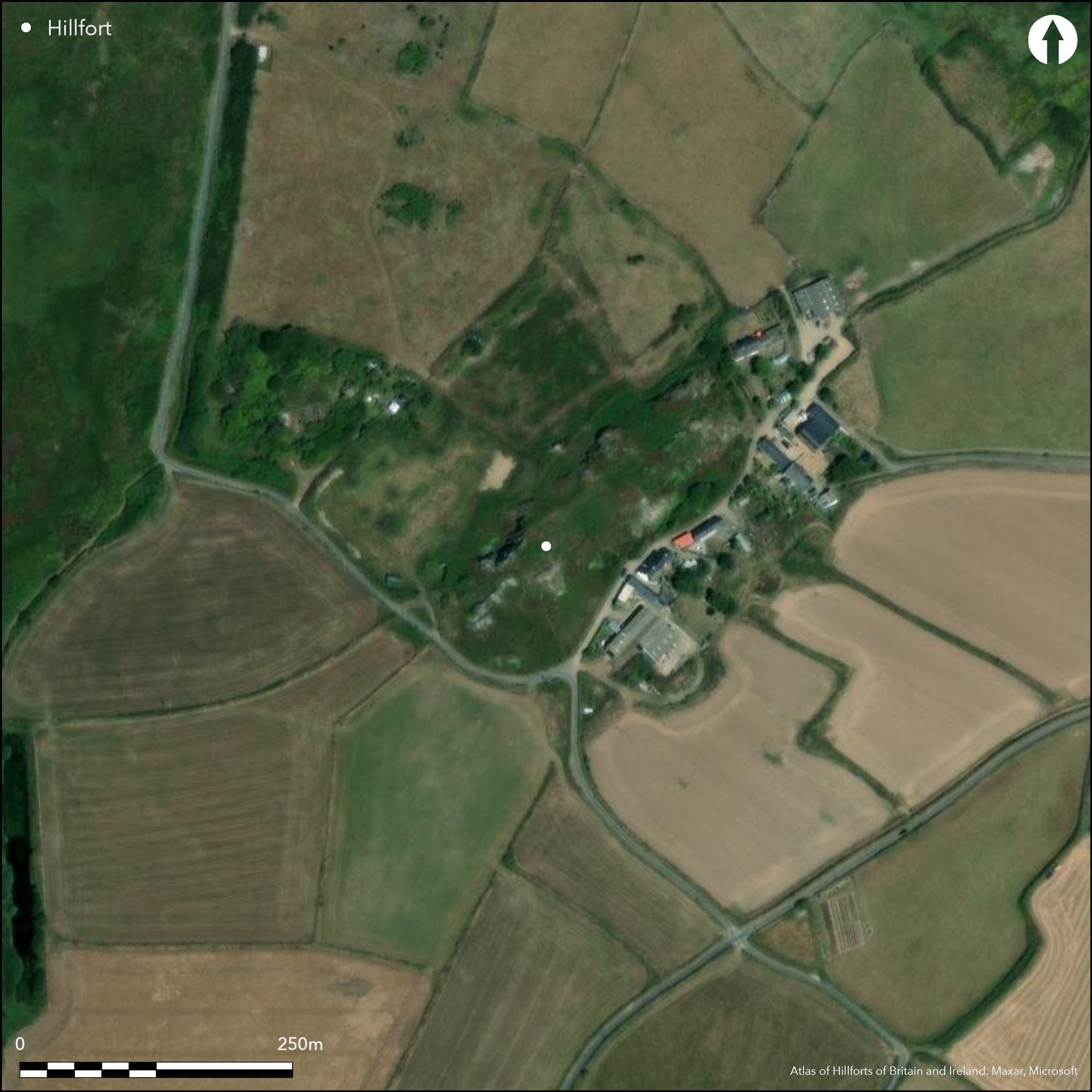
Satellite Imagery
Satellite Imagery
HER: Dyfed 2655 (None)
NMR: SM 72 NW (305389)
SM: PE109(PEM)
NGR: SM73732509
X: 173730 Y: 225090 (OSGB36)
Small, rocky, stone-walled, possible partial contour hillfort or settlement located on S part of an isolated NE-SW rocky knoll 10-20m above coastal plain near sea and to W of St. David's. Moderate to strong surrounding slopes. Rectangular enclosure only 85m NE-SW by 28m with internal area 0.22ha. Defined by rampart rising 0.6m and to 4.6m wide above interior and using natural outcrops in its circuit. Rampart composed of stone rubble and earth revetted with stone blocks, no ditch. Excavated by Rev. S. Baring-Gould in 1902 and Audrey Williams in 1943 confirming occupation in Neolithic and Iron Age. Evidence of round and rectangular huts of timber and daub found together with a midden. Hard, round-bottomed, Neolithic pottery, as found at burial chambers such as Carreg Coetan, and polished stone axes and scrapers. This evidence of a later earthen rampart, with inner and outer stone revetment, plus possible roofed guard chamber and double timber gates, has suggested Iron Age interest, but 6th century AD, or indeed Neolithic again, has also been put forward. But its status as a hillfort is open to doubt. Name 'Clegyr Boia' associates site as stronghold of 6th century AD Irish pirate named Boia. Rough grass, bracken, gorse and scrub and bare rock. Farm buildings just below fort on SE. Site in good condition but difficult to interpret. On 1st Ed. OS map (1889).
Citizen Science: ✗
Reliability of Data: Confirmed
Reliability of Interpretation: Confirmed
X: -588756 Y: 6778153 (EPSG: 3857)
Longitude: -5.288883465999254 Latitude: 51.87831197721781 (EPSG:4326)
Country: Wales
Current County or Unitary Authority: Pembrokeshire
Historic County: Pembrokeshire
Current Parish/Community/Council/Townland: St Davids and the Cathedral Close St David's
Site in good condition but difficult to interrpret.
| Extant | ✓ |
| Cropmark | ✗ |
| Likely Destroyed | ✗ |
Rough grass, bracken, gorse and scrub and bare rock.Farm buildings just below fort on SE.
| Woodland | ✗ |
| Commercial Forestry Plantation | ✗ |
| Parkland | ✗ |
| Pasture (Grazing) | ✗ |
| Arable | ✗ |
| Scrub/Bracken | ✓ |
| Bare Outcrop | ✗ |
| Heather/Moorland | ✗ |
| Heath | ✗ |
| Built-up | ✗ |
| Coastal Grassland | ✗ |
| Other | ✗ |
Small, rocky, stone-walled, partial contour hillfort or settlement located on S part of an isolated NE-SW rocky knoll amid coastal plain near sea and to W of St. David's. Moderate to strong surrounding slopes.
| Contour Fort | ✓ |
| Partial Contour Fort | ✗ |
| Promontory Fort | ✗ |
| Hillslope Fort | ✗ |
| Level Terrain Fort | ✗ |
| Marsh Fort | ✗ |
| Multiple Enclosure Fort | ✗ |
| Hilltop | ✗ |
| Coastal Promontory | ✗ |
| Inland Promontory | ✗ |
| Valley Bottom | ✗ |
| Knoll/Hillock/Outcrop | ✓ |
| Ridge | ✗ |
| Cliff/Plateau-edge/Scarp | ✗ |
| Hillslope | ✗ |
| Lowland | ✗ |
| Spur | ✗ |
Dominant Topographic Feature: Rocky knoll
| North | ✗ |
| Northeast | ✗ |
| East | ✗ |
| Southeast | ✗ |
| South | ✗ |
| Southwest | ✗ |
| West | ✗ |
| Northwest | ✗ |
| Level | ✓ |
Altitude: 60.0m
N/A
Excavations confirmed occupation in Neolithic and Iron Age. Radio-carbon date from charcoal associated with the gate centres on the general period 0 BC/AD (James & Williams 1982, 304) returning calibrated C14 dates of 760-380 BC and 350BC-AD400. Evidence of the later earthen rampart ,with inner and outer stone revetment, plus possible roofed guard chamber and double timber gates has also suggested Iron Age interest, but 6th century AD, or indeed Neolithic again, has been put forward.
Reliability: B - Medium
| Pre 1200BC | ✗ |
| 1200BC - 800BC | ✗ |
| 800BC - 400BC | ✓ |
| 400BC - AD50 | ✓ |
| AD50 - AD400 | ✗ |
| AD400 - AD 800 | ✗ |
| Post AD800 | ✗ |
| Unknown | ✗ |
| Pre Hillfort: | None |
| Post Hillfort: | None |
| Artefactual: | Pottery |
| C14: | C14 from gate centres on the general period 0 BC/AD, returning calibrated radiocarbon dates of 760-380 BC and 350BC-AD400. |
| Morphology/Earthwork/Typology: | Evidence of a later later earthen rampart with inner and outer stone revetment plus possible roofed guard chamber and double timber gates has suggested Iron Age interest, but 6th century AD or indeed Neolithic has been put forward. |
On 1st Ed. OS map (1889). Excavation Rev. S. Baring-Gould 1902. Field Observation OS 1973. Field Observtion AMB 1981. Field Observation CADW 1996. Cambria Archaeology defended enclosures survey 2006-2007.
| 1st Identified Map Depiction (1889): | OS map. |
| Excavation (1902): | Rev S. Baring-Gould. |
| Excavation (1943): | A. Williams. |
| Other (1973): | Field Observation OS. |
| Other (1973): | Visited by Hillfort Study Group |
| Other (1981): | Field Observtion AMB. |
| Other (1996): | Field observation CADW. |
| Other (None): | Cambria Archaeology defended enclosures survey. |
Evidence of round and rectangular huts of timber and daub found together with a midden. Hard round-bottomed Neolithic pottery, as found at burial chambers such as Carreg Coetan, and polished stone axes and scrapers.
Stream 0.35km outside fort.
| None | ✓ |
| Spring | ✗ |
| Stream | ✗ |
| Pool | ✗ |
| Flush | ✗ |
| Well | ✗ |
| Other | ✗ |
None
| No Known Features | ✓ |
| Round Stone Structures | ✗ |
| Rectangular Stone Structures | ✗ |
| Curvilinear Platforms | ✗ |
| Other Roundhouse Evidence | ✗ |
| Pits | ✗ |
| Quarry Hollows | ✗ |
| Other | ✗ |
Evidence of round and rectangular huts of timber and daub found together with a midden.
| No Known Excavation | ✗ |
| Pits | ✗ |
| Postholes | ✗ |
| Roundhouses | ✓ |
| Rectangular Structures | ✓ |
| Roads/Tracks | ✗ |
| Quarry Hollows | ✗ |
| Other | ✓ |
| Nothing Found | ✗ |
None
| No Known Geophysics | ✓ |
| Pits | ✗ |
| Roundhouses | ✗ |
| Rectangular Structures | ✗ |
| Roads/Tracks | ✗ |
| Quarry Hollows | ✗ |
| Other | ✗ |
| Nothing Found | ✗ |
Hard, round-bottomed, Neolithic pottery, as found at burial chambers such as Carreg Coetan, and polished stone axes and scrapers.
| No Known Finds | ✗ |
| Pottery | ✓ |
| Metal | ✗ |
| Metalworking | ✗ |
| Human Bones | ✗ |
| Animal Bones | ✗ |
| Lithics | ✓ |
| Environmental | ✗ |
| Other | ✗ |
None
| APs Not Checked | ✓ |
| None | ✗ |
| Roundhouses | ✗ |
| Rectangular Structures | ✗ |
| Pits | ✗ |
| Postholes | ✗ |
| Roads/Tracks | ✗ |
| Other | ✗ |
Complex inturned entrance on SW, with flanking walls 6.1m long, with stone revetment. Possible roofed pair of guard chambers, with post holes at each end, and double timber gates.
| 1: | None |
| 2: | None |
Guard Chambers: ✓
Chevaux de Frise: ✗
| 1. In-turned (South west): | Complex. |
| 1. Recesses/Guard Chambers (South west): | None |
| 1. Passage-way/Corridor (South west): | None |
Defined by rampart rising 0.6m and to 4.6m wide above interior and using natural outcrops in its circuit. Rampart composed of stone rubble and earth revetted with stone blocks. No ditch.
| Area 1: | 0.22ha. |
| Total: | 0.22ha. |
Total Footprint Area: Noneha.
None
| ✗ | None |
| ✓ | Possible second rampart on NE. |
| NE Quadrant: | 2 |
| SE Quadrant: | 1 |
| SW Quadrant: | 1 |
| NW Quadrant: | 1 |
| Total: | 2 |
| Partial Univallate | ✓ |
| Univallate | ✗ |
| Partial Bivallate | ✓ |
| Bivallate | ✗ |
| Partial Multivallate | ✗ |
| Multivallate | ✗ |
| Unknown | ✗ |
| Partial Univallate | ✗ |
| Univallate | ✗ |
| Partial Bivallate | ✗ |
| Bivallate | ✗ |
| Partial Multivallate | ✗ |
| Multivallate | ✗ |
Stone-walled site. Rampart composed of stone rubble and earth.
| None | ✗ |
| Earthen Bank | ✓ |
| Stone Wall | ✓ |
| Rubble | ✓ |
| Wall-walk | ✗ |
| Evidence of Timber | ✗ |
| Vitrification | ✗ |
| Other Burning | ✗ |
| Palisade | ✗ |
| Counter Scarp Bank | ✗ |
| Berm | ✗ |
| Unfinished | ✗ |
| Other | ✗ |
Rampart composed of stone rubble and earth revetted with stone blocks.
| None | ✗ |
| Earthen Bank | ✓ |
| Stone Wall | ✓ |
| Murus Duplex | ✗ |
| Timber-framed | ✗ |
| Timber-laced | ✗ |
| Vitrification | ✗ |
| Other Burning | ✗ |
| Palisade | ✗ |
| Counter Scarp Bank | ✗ |
| Berm | ✗ |
| Unfinished | ✗ |
| No Known Excavation | ✗ |
| Other | ✗ |
| ✗ | None |
| ✗ | None |
Number of Ditches: 0
| ✗ | None |
Baring-Gould, S. 1903. The exploration of Clegyr Voia, Arch Camb, 6th Series, 3, 1-111.
Driver, T. 2007. Pembrokeshire, Historic Landscapes from the Air, Aberystwyth: RCAHMW, 98.
James, H. and Williams, G. 1982. Rural settlement in Dyfed. In D. Miles (ed.) The Romano British Countryside, BAR (British Series) 103. Oxford, 289-312.
Murphy, K., Ramsey, R., Poucher, P. and Page, M. 2007. A Survey of Defended Enclosures in Pembrokeshire, 2006-2007: Gazetteer of Ordnance Survey Grid Squares SM72 and SM82, Cambria Archaeology Report No. 2007/01, Project Record No. 54269, Llandeilo: Cambria Archaeology.
RCAMWM 1925. An inventory of the ancient monuments in Wales and Monmouthshire, VII, County of Pembroke, London: HMSO, No. 948.
Rees, S. 1992. A guide to ancient and historic Wales - Dyfed, London: HMSO, 71-2.
Williams, A. 1952. Clegyr Boia, St. David's (Pemb.): Excavations in 1943, Arch Camb, 102, 20-47.
Atlas of Hillforts:
Wikidata:
This work is licensed under CC BY-SA 4.0

 and should be cited as:
Lock, Gary and Ralston, Ian. 2024. Atlas of Hillforts of Britain and Ireland. Available at: https://hillforts.arch.ox.ac.uk
Document Version 1.1