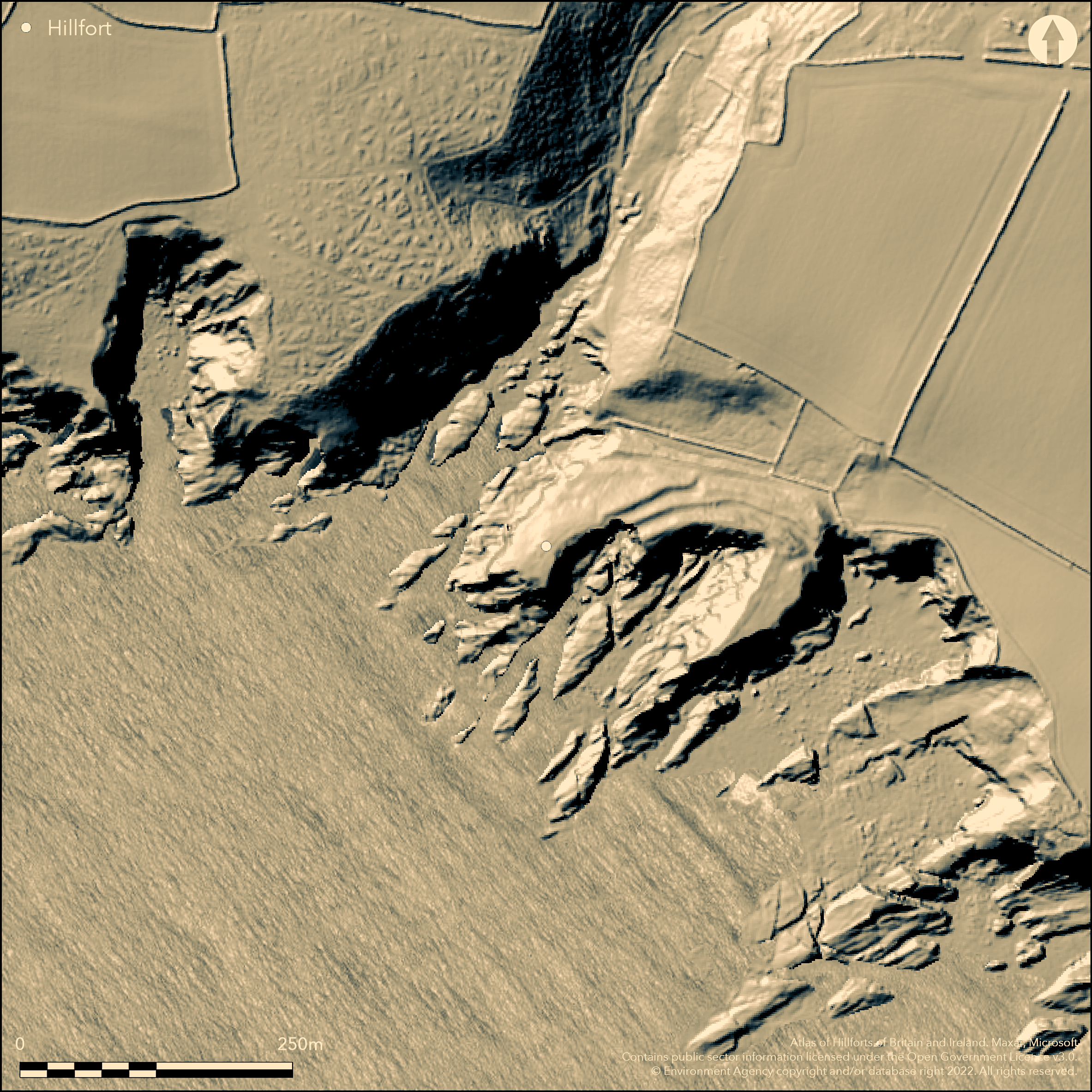
LiDAR 1m DTM Hillshade
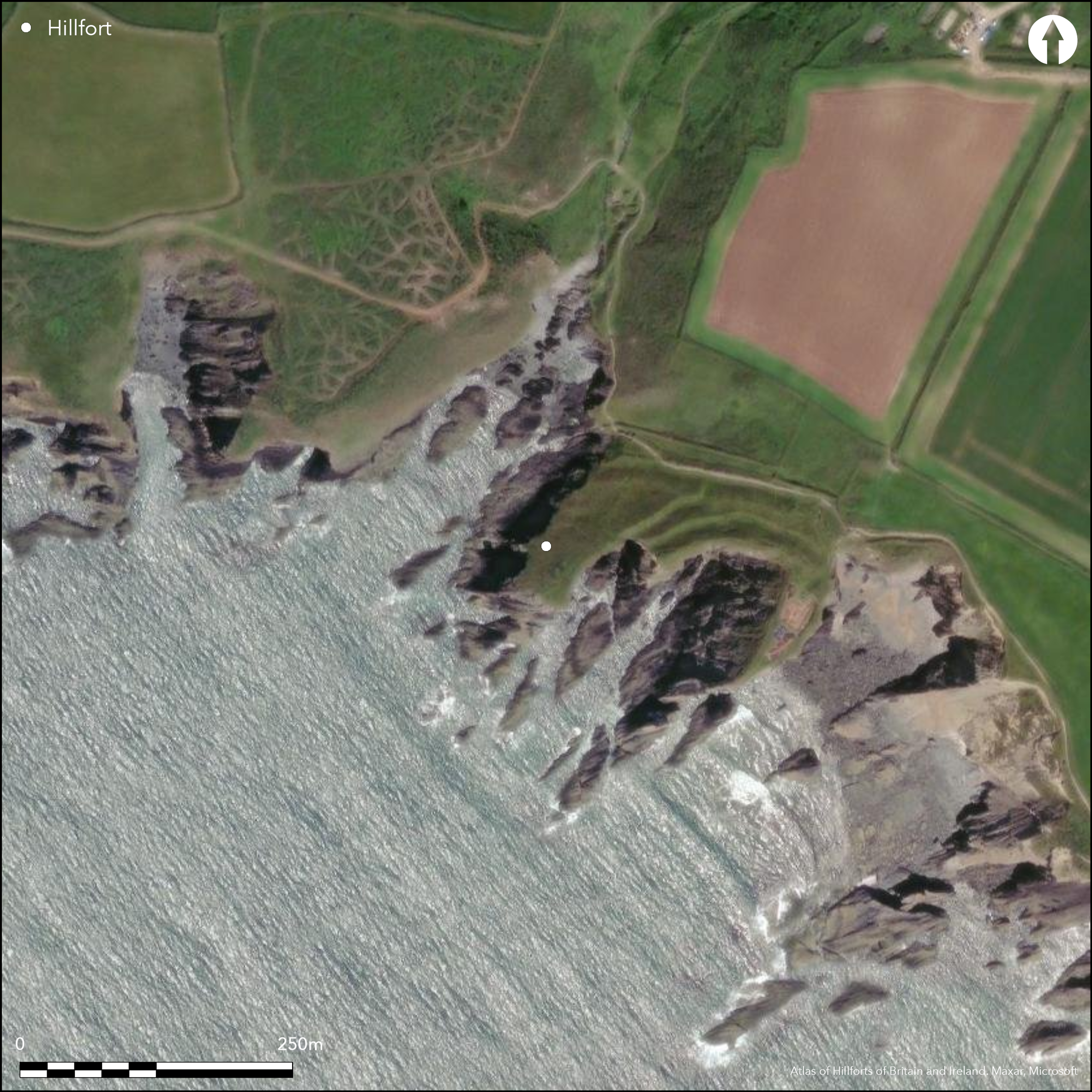
Satellite Imagery
LiDAR 1m DTM Hillshade
Satellite Imagery
Scroll left/right to view further images.
HER: Dyfed 2721 (None)
NMR: SM 72 SE 4 (94210)
SM: PE273(PEM)
NGR: SM 786 242
X: 178600 Y: 224200 (OSGB36)
Multivallate coastal promontory fort located on SW-facing promontory dominating Porth y Rhaw on the N shore of St Brides Bay. One of the few recently excavated coastal promontory forts. High sea cliffs to 30m to SE, SW and NW, landward to coastal plateau on NE. Just to N of the ramparts land falls into narrow valley. Erosion has now reduced interior to two small promontories, measuring 70m N-S by 25 to E and the 70m NE-SW by 30m to W, enclosing 0.44ha, and already much eroded when Fenton visited in 1808-09. These two small promontories are cut off by four formidable banks and ditches, inner bank giving monumental aspect to site. Three curving inner banks close-set and parallel,c. 120m long, with inner bank to 4m above ditch, second and third less substantial at 1m-2m above ditches. Outer bank c. 20m lower than inner because of slope and is straighter, possibly showing phased construction. Close to cliff edge on E is entrance gap through inner bank. Second and third banks stop short of cliff edge and probably lost to sea. Excavations 1995-98 (Crane and Murphy 2010) found at least seven timber and one stone roundhouses, some rebuilt up to five times. Excavation focussed on possible structures on E promontory, with C14 dates showing occupation starting in late Bronze Age, with fine Roman tableware pottery indicating continued use to 4th century AD. Metal working undertaken and manufacture of glass beads similar to those found on Foel Drygarn hillfort (Atlas No 1895). Site much eroded under coastal grassland and bare rock with some scrub. On 1st Ed. OS map (1891).
Citizen Science: ✗
Reliability of Data: Confirmed
Reliability of Interpretation: Confirmed
X: -580829 Y: 6777064 (EPSG: 3857)
Longitude: -5.21767846368102 Latitude: 51.87227760516268 (EPSG:4326)
Country: Wales
Current County or Unitary Authority: Pembrokeshire
Historic County: Pembrokeshire
Current Parish/Community/Council/Townland: Solva
Around three-quarters of the site eroded by the sea. Pembrokeshire Coast Path to NE.
| Extant | ✓ |
| Cropmark | ✗ |
| Likely Destroyed | ✗ |
Coastal grassland and bare rock with some scrub.
| Woodland | ✗ |
| Commercial Forestry Plantation | ✗ |
| Parkland | ✗ |
| Pasture (Grazing) | ✗ |
| Arable | ✗ |
| Scrub/Bracken | ✓ |
| Bare Outcrop | ✗ |
| Heather/Moorland | ✗ |
| Heath | ✗ |
| Built-up | ✗ |
| Coastal Grassland | ✓ |
| Other | ✗ |
Multivallate coastal promontory fort located on SW-facing promontory dominating Porth y Rhaw on the N shore of St Bride's Bay. High sea cliffs to 30m to SE, SW and NW, landward to coastal plateau on NE. Erosion reduced interior to two small promontories, measuring 70m N-S by 25 to E and the 70m NE-SW by 30m to W.
| Contour Fort | ✗ |
| Partial Contour Fort | ✗ |
| Promontory Fort | ✓ |
| Hillslope Fort | ✗ |
| Level Terrain Fort | ✗ |
| Marsh Fort | ✗ |
| Multiple Enclosure Fort | ✗ |
| Hilltop | ✗ |
| Coastal Promontory | ✓ |
| Inland Promontory | ✗ |
| Valley Bottom | ✗ |
| Knoll/Hillock/Outcrop | ✗ |
| Ridge | ✗ |
| Cliff/Plateau-edge/Scarp | ✗ |
| Hillslope | ✗ |
| Lowland | ✗ |
| Spur | ✗ |
Dominant Topographic Feature: Coastal promontories
| North | ✗ |
| Northeast | ✗ |
| East | ✗ |
| Southeast | ✗ |
| South | ✗ |
| Southwest | ✓ |
| West | ✗ |
| Northwest | ✗ |
| Level | ✗ |
Altitude: 15.0m
N/A
Excavation in 1995-8, with nine C14 dates showing occupation starting during late Bronze Age and extending to fourth to first millennium BC, with total range 824 cal. BC to 53 cal. BC, with one sample from Roundhouse VIII later at 130 cal. AD to 531 cal. AD. Pottery also indicated continued use to 4th century AD in E part of site.
Reliability: A - High
| Pre 1200BC | ✗ |
| 1200BC - 800BC | ✓ |
| 800BC - 400BC | ✓ |
| 400BC - AD50 | ✓ |
| AD50 - AD400 | ✓ |
| AD400 - AD 800 | ✓ |
| Post AD800 | ✗ |
| Unknown | ✗ |
| Pre Hillfort: | None |
| Post Hillfort: | None |
| Artefactual: | Pottery indicating continued use to 4th century AD in E part of site. |
| C14: | Nine C14 dates showing occupation starting during late Bronze Age and extending to fourth to first millennium BC, with total range 824 cal. BC to 53 cal. BC, with one sample from Roundhouse VIII later at 130 cal. AD to 531 cal. AD. |
Visited by Richard Fenton 1808-09. On 1st Ed. OS map (1891). Field Observation OS 1973. Field Observation AMB 1981. Field Observation Arch Survey NT 1989. Field Observation CADW 1994. Field Observation DAT 1993. Part Survey DAT 1994. Excavation DAT 1995-1998. Cambria Archaeology defended enclosures survey 2006-2007. LiDAR and topographic survey (Page et al 2008).
| 1st Identified Map Depiction (1891): | OS map. |
| Other (1973): | Field observation OS. |
| Other (1981): | Field observation AMB. |
| Other (1989): | Field Observation Arch Survey NT. |
| Other (1993): | Field observation DAT. |
| Other (1994): | Field observation CADW. |
| Other (1994): | Part survey DAT. |
| LiDAR Survey (2008): | None |
| 1st Identified Written Reference (None): | Richard Fenton visit. |
| Excavation (None): | Cambria Archaeology/DAT. |
| Other (None): | Cambria Archaeology defended enclosures survey. |
| Geophysical Survey (None): | RCAHMW? |
Excavations 1995-98 found at least seven timber and one stone roundhouses, some rebuilt up to five times. Fine Roman tableware. Metal working undertaken and manufacture of glass beads. RCAHMW (Coflein) indicate geophysical survey detected stone built roundhouse, partly excavated in the 1990s, and several of the timber-built roundhouses. Geophysical signals from timber roundhouses weak, and uncertain whether these would have been correctly interpreted without the excavation evidence.
None
| None | ✓ |
| Spring | ✗ |
| Stream | ✗ |
| Pool | ✗ |
| Flush | ✗ |
| Well | ✗ |
| Other | ✗ |
Structure sites.
| No Known Features | ✗ |
| Round Stone Structures | ✗ |
| Rectangular Stone Structures | ✗ |
| Curvilinear Platforms | ✓ |
| Other Roundhouse Evidence | ✗ |
| Pits | ✗ |
| Quarry Hollows | ✗ |
| Other | ✗ |
Excavations 1995-98 found at least seven timber and one stone roundhouses, some rebuilt several times.
| No Known Excavation | ✗ |
| Pits | ✗ |
| Postholes | ✗ |
| Roundhouses | ✓ |
| Rectangular Structures | ✗ |
| Roads/Tracks | ✗ |
| Quarry Hollows | ✗ |
| Other | ✗ |
| Nothing Found | ✗ |
RCAHMW (Coflein) indicate geophysical survey detected stone built roundhouse, partly excavated in the 1990s, and several of the timber-built roundhouses. Geophysical signals from timber roundhouses weak, and uncertain whether these would have been correctly interpreted without the excavation evidence.
| No Known Geophysics | ✗ |
| Pits | ✗ |
| Roundhouses | ✓ |
| Rectangular Structures | ✗ |
| Roads/Tracks | ✗ |
| Quarry Hollows | ✗ |
| Other | ✗ |
| Nothing Found | ✗ |
Fine Roman tableware. Metal working undertaken and manufacture of glass beads similar to those found on Foel Drygarn hillfort (Atlas No. 1895). One amber bead. Flint items. Metal residues and crucible fragments. Iron slag. Stone counters. Spindle whorls.
| No Known Finds | ✗ |
| Pottery | ✓ |
| Metal | ✓ |
| Metalworking | ✓ |
| Human Bones | ✗ |
| Animal Bones | ✗ |
| Lithics | ✓ |
| Environmental | ✗ |
| Other | ✓ |
None
| APs Not Checked | ✓ |
| None | ✗ |
| Roundhouses | ✗ |
| Rectangular Structures | ✗ |
| Pits | ✗ |
| Postholes | ✗ |
| Roads/Tracks | ✗ |
| Other | ✗ |
Close to cliff edge on E is entrance gap through inner bank.
| 1: | None |
| 2: | None |
Guard Chambers: ✗
Chevaux de Frise: ✗
| 1. Simple Gap (North east): | None |
Three curving inner banks close-set and parallel,c. 120m long, with inner bank to 4m above ditch, second and third less substantial at 1m-2m above ditches. Outer bank c. 20m lower than inner because of slope and is straighter, possibly showing phased construction. Second and third banks stop short of cliff edge and probably lost to sea.
| Area 1: | 0.44ha. |
| Total: | 0.44ha. |
Total Footprint Area: Noneha.
None
| ✓ | Outer bank c. 20m lower than inner because of slope and is straighter, possibly showing phased construction, but no details. |
| ✗ | None |
| NE Quadrant: | 4 |
| SE Quadrant: | 0 |
| SW Quadrant: | 0 |
| NW Quadrant: | 0 |
| Total: | 4 |
| Partial Univallate | ✗ |
| Univallate | ✗ |
| Partial Bivallate | ✗ |
| Bivallate | ✗ |
| Partial Multivallate | ✓ |
| Multivallate | ✗ |
| Unknown | ✗ |
| Partial Univallate | ✗ |
| Univallate | ✗ |
| Partial Bivallate | ✗ |
| Bivallate | ✗ |
| Partial Multivallate | ✗ |
| Multivallate | ✗ |
None
| None | ✗ |
| Earthen Bank | ✓ |
| Stone Wall | ✗ |
| Rubble | ✓ |
| Wall-walk | ✗ |
| Evidence of Timber | ✗ |
| Vitrification | ✗ |
| Other Burning | ✗ |
| Palisade | ✗ |
| Counter Scarp Bank | ✗ |
| Berm | ✗ |
| Unfinished | ✗ |
| Other | ✗ |
Excavation focussed on interior structures.
| None | ✗ |
| Earthen Bank | ✗ |
| Stone Wall | ✗ |
| Murus Duplex | ✗ |
| Timber-framed | ✗ |
| Timber-laced | ✗ |
| Vitrification | ✗ |
| Other Burning | ✗ |
| Palisade | ✗ |
| Counter Scarp Bank | ✗ |
| Berm | ✗ |
| Unfinished | ✗ |
| No Known Excavation | ✓ |
| Other | ✓ |
| ✗ | None |
| ✓ | None |
Number of Ditches: 4
| ✗ | None |
Crane, P. and Murphy, K. 2010. The excavation of a coastal promontory fort at Porth y Rhaw, Solva, Pembrokeshire, 1995-1998. Archaeol Cambrensis, 159, 53-98.
Crossley, D.W. 1963. List of Hill-Forts and other earthworks in Pembrokeshire, Bull Board Celtic Stud, 20, 175.
Driver, T. 2007. Pembrokeshire. Historic landscapes from the air, Aberystwyth: RCAHMW, 107.
Fenton, R. 1903. A historical tour through Pembrokeshire, Facsimile of 2nd edn., Dyfed County Council 1994.
Jones, B. and Freeman, E.A. 1856. The history and antiquity of Saint David's, London.
Murphy, K., Ramsey, R., Poucher, P. and Page, M. 2007. A Survey of Defended Enclosures in Pembrokeshire, 2006-2007: Gazetteer of Ordnance Survey Grid Squares SM72 and SM82, Cambria Archaeology Report No. 2007/01, Project Record No. 54269, Llandeilo: Cambria Archaeology.
Page, M., Barker, L., Driver, T. and Murphy, K. 2008. Remote sensing and the Iron Age coastal promontory forts of Pembrokeshire, Arch in Wales, 48, 27-38.
RCAMWM 1925. An inventory of the ancient monuments in Wales and Monmouthshire, VII, County of Pembroke, London: HMSO, No. 1168.
Atlas of Hillforts:
Wikidata:
This work is licensed under CC BY-SA 4.0

 and should be cited as:
Lock, Gary and Ralston, Ian. 2024. Atlas of Hillforts of Britain and Ireland. Available at: https://hillforts.arch.ox.ac.uk
Document Version 1.1