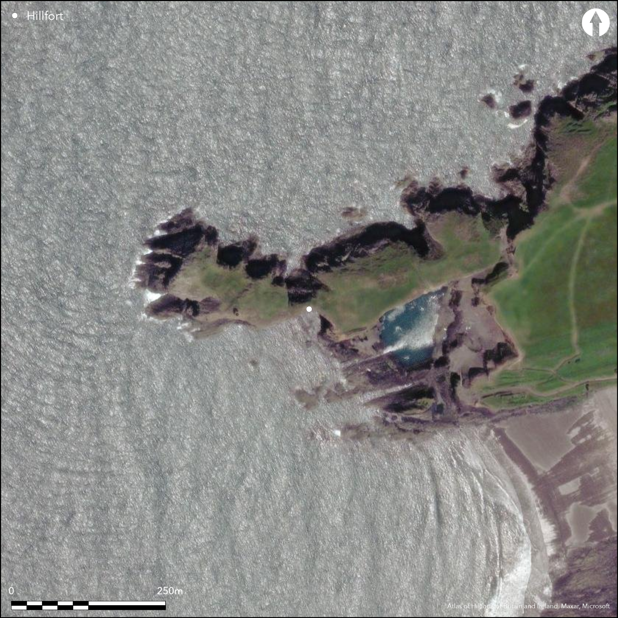
Satellite Imagery
Satellite Imagery
HER: Dyfed 2733 (None)
NMR: SM 73 SE (102710)
SM: None
NGR: SM 7940 3149
X: 179400 Y: 231490 (OSGB36)
Small and complex coastal promontory fort located on prominent W-facing, rocky promontory immediately N of Abereiddi Bay on N coast. Promontory 270m long jutting out into Irish Sea. Sea cliffs to N, S and W, landward to coastal plateau on E. Multivallate, and eroded on S, defences cut off the promontory c. 140m from tip to give enclosed area c. 110m by 60m, with area estimated at c. 0.66ha. Defences difficult to determine and have been investigated by DAT. They consist of four or five banks and ditch. Outer bank on E most massive, with no outer ditch, but to c. 4m wide and over 3m above a rock-cut ditch on its inner W side. Second bank to W consists of unexcavated bedrock between two ditches, rather than built bank. Two more sets of slight bank and ditch to W then gap of 20m. Here promontory widens out and protected by a further bank running along a natural rise. Entrance possibly on S side, where all banks stop short of sea cliff. N slope steep and here quarrying, but to W several slight platforms cut into slope may be hut sites. Post medieval Abereiddi Tower to W at highest point of promontory. Ditch running N-S c. 140m E of defences modern quarrying and further to E massive modern quarrying isolates whole of rpomontory from mainland. Site under rich coastal grassland with bare rock exposed. On 1st Ed. OS map (1889). Minimal investigations, undated.
Citizen Science: ✗
Reliability of Data: Confirmed
Reliability of Interpretation: Confirmed
X: -580057 Y: 6788929 (EPSG: 3857)
Longitude: -5.210744005981817 Latitude: 51.93803635823904 (EPSG:4326)
Country: Wales
Current County or Unitary Authority: Pembrokeshire
Historic County: Pembrokeshire
Current Parish/Community/Council/Townland: Llanrhian
S side eroded making interpretation difficult. Quarrying to N slope. Post medieval Abereiddi Tower to W at highest point of promontory. Pembrokeshire Coast Path to E. Modern quarrying to E isolates whole of promontory from mainland.
| Extant | ✓ |
| Cropmark | ✗ |
| Likely Destroyed | ✗ |
Site under coastal grassland with bare rock exposed. Post medieval Abereiddi Tower to W at highest point of promontory. Quarrying.
| Woodland | ✗ |
| Commercial Forestry Plantation | ✗ |
| Parkland | ✗ |
| Pasture (Grazing) | ✗ |
| Arable | ✗ |
| Scrub/Bracken | ✗ |
| Bare Outcrop | ✗ |
| Heather/Moorland | ✗ |
| Heath | ✗ |
| Built-up | ✗ |
| Coastal Grassland | ✓ |
| Other | ✓ |
Small and complex coastal promontory fort located on prominent, W-facing, rocky promontory immediately N of Abereiddi Bay on N coast.Promontory 270m long jutting out into Irish Sea. Sea cliffs to N, S and W, landward to coastal plateau on E.
| Contour Fort | ✗ |
| Partial Contour Fort | ✗ |
| Promontory Fort | ✓ |
| Hillslope Fort | ✗ |
| Level Terrain Fort | ✗ |
| Marsh Fort | ✗ |
| Multiple Enclosure Fort | ✗ |
| Hilltop | ✗ |
| Coastal Promontory | ✓ |
| Inland Promontory | ✗ |
| Valley Bottom | ✗ |
| Knoll/Hillock/Outcrop | ✗ |
| Ridge | ✗ |
| Cliff/Plateau-edge/Scarp | ✗ |
| Hillslope | ✗ |
| Lowland | ✗ |
| Spur | ✗ |
Dominant Topographic Feature: Coastal promontory
| North | ✗ |
| Northeast | ✗ |
| East | ✗ |
| Southeast | ✗ |
| South | ✗ |
| Southwest | ✗ |
| West | ✓ |
| Northwest | ✗ |
| Level | ✗ |
Altitude: 35.0m
N/A
None
Reliability: D - None
| Pre 1200BC | ✗ |
| 1200BC - 800BC | ✗ |
| 800BC - 400BC | ✗ |
| 400BC - AD50 | ✗ |
| AD50 - AD400 | ✗ |
| AD400 - AD 800 | ✗ |
| Post AD800 | ✗ |
| Unknown | ✓ |
| Pre Hillfort: | None |
| Post Hillfort: | None |
On 1st Ed. OS map (1889). Field Observation OS 1966. Field Observation Arch Survey NT1989. Field Observation DAT 1994, 1996, 2006. Cambria Archaeology defended enclosures survey 2006-2007.
| 1st Identified Map Depiction (1889): | OS map. |
| Other (1966): | Field observation OS. |
| Other (1989): | Field Observation Arch Survey NT. |
| Other (None): | Field observation DAT. |
| Other (None): | Cambria Archaeology defended enclosures survey. |
To W several slight platforms cut into slope may be hut sites.
None
| None | ✓ |
| Spring | ✗ |
| Stream | ✗ |
| Pool | ✗ |
| Flush | ✗ |
| Well | ✗ |
| Other | ✗ |
To W several slight platforms cut into slope may be hut sites.
| No Known Features | ✗ |
| Round Stone Structures | ✗ |
| Rectangular Stone Structures | ✗ |
| Curvilinear Platforms | ✓ |
| Other Roundhouse Evidence | ✗ |
| Pits | ✗ |
| Quarry Hollows | ✗ |
| Other | ✗ |
None
| No Known Excavation | ✓ |
| Pits | ✗ |
| Postholes | ✗ |
| Roundhouses | ✗ |
| Rectangular Structures | ✗ |
| Roads/Tracks | ✗ |
| Quarry Hollows | ✗ |
| Other | ✗ |
| Nothing Found | ✗ |
None
| No Known Geophysics | ✓ |
| Pits | ✗ |
| Roundhouses | ✗ |
| Rectangular Structures | ✗ |
| Roads/Tracks | ✗ |
| Quarry Hollows | ✗ |
| Other | ✗ |
| Nothing Found | ✗ |
None
| No Known Finds | ✓ |
| Pottery | ✗ |
| Metal | ✗ |
| Metalworking | ✗ |
| Human Bones | ✗ |
| Animal Bones | ✗ |
| Lithics | ✗ |
| Environmental | ✗ |
| Other | ✗ |
None
| APs Not Checked | ✓ |
| None | ✗ |
| Roundhouses | ✗ |
| Rectangular Structures | ✗ |
| Pits | ✗ |
| Postholes | ✗ |
| Roads/Tracks | ✗ |
| Other | ✗ |
Entrance possibly on S side, where all banks stop short of sea cliff.
| 1: | None |
| 2: | None |
Guard Chambers: ✗
Chevaux de Frise: ✗
| 1. Simple Gap (South east): | None |
Four or five banks and ditch. Outer bank on E most massive, with no outer ditch, but to c. 4m wide and over 3m above a rock-cut ditch on its inner W side. Second bank to W consists of unexcavated bedrock between two ditches, rather than built bank. Two more sets of slight bank and ditch to W then gap of 20m. Here promontory widens out and protected by a further bank running along a natural rise.
| Area 1: | 0.66ha. |
| Total: | 0.66ha. |
Total Footprint Area: Noneha.
None
| ✗ | Estimated area. |
| ✗ | Four or five banks defined. |
| NE Quadrant: | 5 |
| SE Quadrant: | 5 |
| SW Quadrant: | 0 |
| NW Quadrant: | 0 |
| Total: | 5 |
| Partial Univallate | ✗ |
| Univallate | ✗ |
| Partial Bivallate | ✗ |
| Bivallate | ✗ |
| Partial Multivallate | ✓ |
| Multivallate | ✗ |
| Unknown | ✗ |
| Partial Univallate | ✗ |
| Univallate | ✗ |
| Partial Bivallate | ✗ |
| Bivallate | ✗ |
| Partial Multivallate | ✗ |
| Multivallate | ✗ |
Possible rubble bank using natural bedrock along line.
| None | ✗ |
| Earthen Bank | ✓ |
| Stone Wall | ✗ |
| Rubble | ✓ |
| Wall-walk | ✗ |
| Evidence of Timber | ✗ |
| Vitrification | ✗ |
| Other Burning | ✗ |
| Palisade | ✗ |
| Counter Scarp Bank | ✗ |
| Berm | ✗ |
| Unfinished | ✗ |
| Other | ✗ |
None
| None | ✗ |
| Earthen Bank | ✗ |
| Stone Wall | ✗ |
| Murus Duplex | ✗ |
| Timber-framed | ✗ |
| Timber-laced | ✗ |
| Vitrification | ✗ |
| Other Burning | ✗ |
| Palisade | ✗ |
| Counter Scarp Bank | ✗ |
| Berm | ✗ |
| Unfinished | ✗ |
| No Known Excavation | ✓ |
| Other | ✗ |
| ✗ | None |
| ✓ | Four or five rock-cut ditches. |
Number of Ditches: 5
| ✗ | None |
Murphy, K., Ramsey, R., Poucher, P. and Page, M. 2007. A Survey of Defended Enclosures in Pembrokeshire, 2006-2007: Gazetteer of Ordnance Survey Grid Squares SM73, SM83 and SM93, Cambria Archaeology Report No. 2007/01, Project Record No. 54269, Llandeilo: Cambria Archaeology.
Atlas of Hillforts:
Wikidata:
This work is licensed under CC BY-SA 4.0

 and should be cited as:
Lock, Gary and Ralston, Ian. 2024. Atlas of Hillforts of Britain and Ireland. Available at: https://hillforts.arch.ox.ac.uk
Document Version 1.1