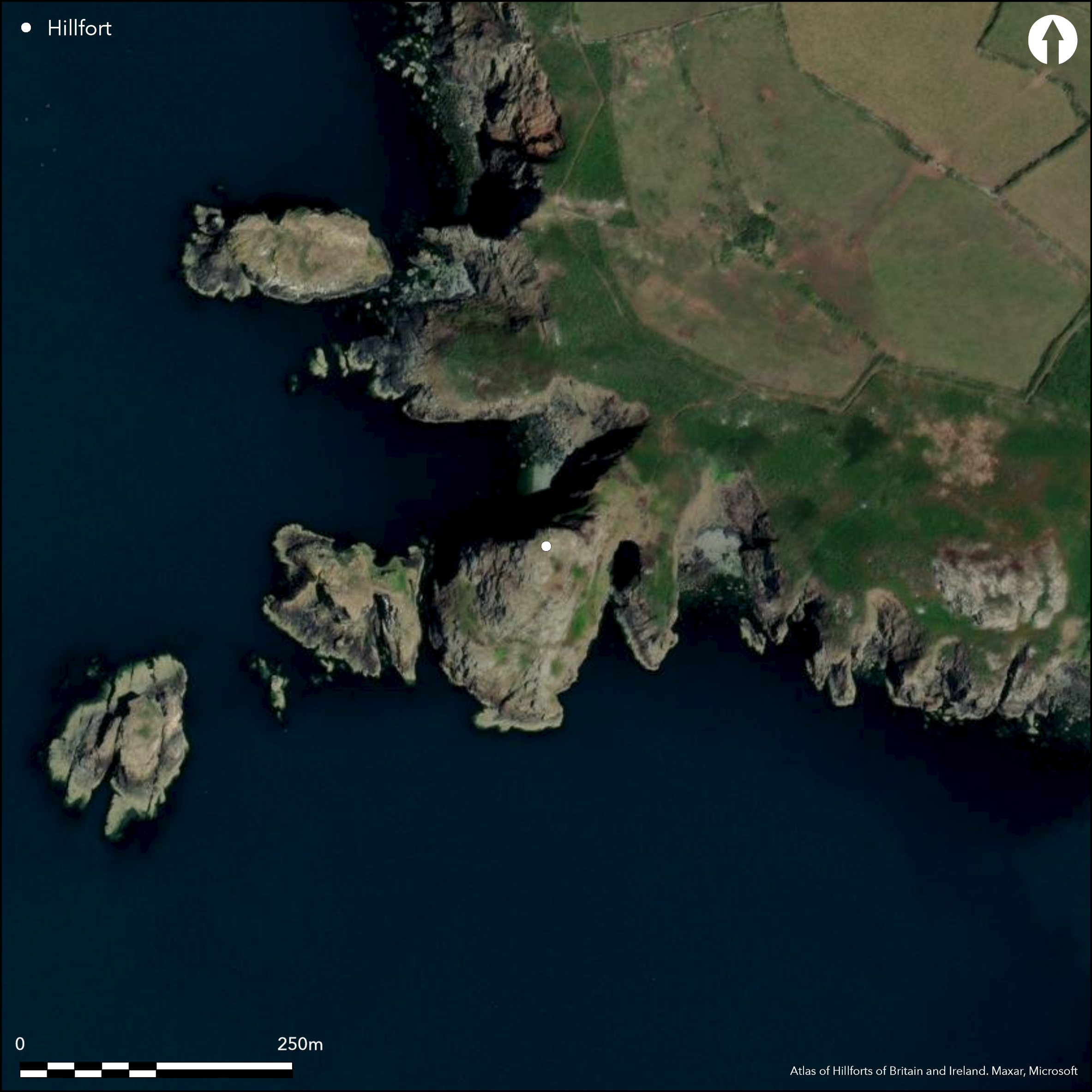
Satellite Imagery
Satellite Imagery
HER: Dyfed 2828 (None)
NMR: SM 83 NE (305289)
SM: PE075(PEM)
NGR: SM 888 387
X: 188800 Y: 238700 (OSGB36)
Bivallate coastal promontory fort located on SW-facing headland dominating the bay N to Pen Brush and S to Penbwchdy. Sea cliffs to N, S and W, E rising to very narrow promontory neck and coastal plateau to NE. Unusual as, although interior measures c. 110m NE-SW with area c. 0.91ha, a massive pinnacle of rock takes up most of the space, leaving only a small grassy area, c. 30m square, immediately inside inner rampart for habitation. Whilst there has been undoubted sea erosion on the site, even so, this rock would have given little space for occupation, and therefore some ritual or ceremonial context should be considered for the site. Examples of cliff castles in Cornwall such as Treryn Dinas (Atlas No 0657 ) and Trereen Dinas (Atlas No 0655) and La Pinnacle on Jersey may have a similar context. At Dinas Mawr two lines of bank and ditch, formerly stone-walls, cut off the promontory at its narrow neck on NE, with the high sea cliffs on the other sides. Inner, c. 45m long, stands to 3m above base of ditch and 1.7m above interior, whilst outer sited c. 25m NE of inner. Most of site covered with coastal grass, with some gorse, and much bare rock. Edward Lluyd's (1707) record of Dinas Mawr worth quoting from RCAHMW (Coflein).... 'a fortification called Dhinas Mawr in the parish of Llanunda, being a Rock above the sea of great height, having 2 ditches, the one north and the other south, running on a precipice into the sea, and two stones pitched on end near the ingress, which looks to ye east.' Dinas Fawr is also shown on the edge of Lluyd's sketch plan of Garn Fawer, also reproduced by the RCAHMW. On 1st Ed. OS map (1889). Minimal investigations, undated.
Citizen Science: ✗
Reliability of Data: Confirmed
Reliability of Interpretation: Confirmed
X: -565352 Y: 6801285 (EPSG: 3857)
Longitude: -5.078646227819075 Latitude: 52.00641525108892 (EPSG:4326)
Country: Wales
Current County or Unitary Authority: Pembrokeshire
Historic County: Pembrokeshire
Current Parish/Community/Council/Townland: Pencaer
Banks intact. Coastal erosion. Pembrokeshire Coast Path to NE.
| Extant | ✓ |
| Cropmark | ✗ |
| Likely Destroyed | ✗ |
Most of site covered with coastal grass, with some gorse, and much bare rock.
| Woodland | ✗ |
| Commercial Forestry Plantation | ✗ |
| Parkland | ✗ |
| Pasture (Grazing) | ✗ |
| Arable | ✗ |
| Scrub/Bracken | ✓ |
| Bare Outcrop | ✗ |
| Heather/Moorland | ✗ |
| Heath | ✗ |
| Built-up | ✗ |
| Coastal Grassland | ✓ |
| Other | ✗ |
Bivallate coastal promontory fort located on SW-facing headland dominating the bay N to Pen Brush and S to Penbwchdy. Sea cliffs to N, S and W, E rising to very narrow promontory neck and coastal plateau to NE. Unusual as, although interior measures c. 110m NE-SW with area c. 0.91ha, a massive pinnacle of rock takes up most of the space.
| Contour Fort | ✗ |
| Partial Contour Fort | ✗ |
| Promontory Fort | ✓ |
| Hillslope Fort | ✗ |
| Level Terrain Fort | ✗ |
| Marsh Fort | ✗ |
| Multiple Enclosure Fort | ✗ |
| Hilltop | ✗ |
| Coastal Promontory | ✓ |
| Inland Promontory | ✗ |
| Valley Bottom | ✗ |
| Knoll/Hillock/Outcrop | ✗ |
| Ridge | ✗ |
| Cliff/Plateau-edge/Scarp | ✗ |
| Hillslope | ✗ |
| Lowland | ✗ |
| Spur | ✗ |
Dominant Topographic Feature: Coastal headland.
| North | ✗ |
| Northeast | ✗ |
| East | ✗ |
| Southeast | ✗ |
| South | ✗ |
| Southwest | ✓ |
| West | ✗ |
| Northwest | ✗ |
| Level | ✗ |
Altitude: 61.0m
N/A
None
Reliability: D - None
| Pre 1200BC | ✗ |
| 1200BC - 800BC | ✗ |
| 800BC - 400BC | ✗ |
| 400BC - AD50 | ✗ |
| AD50 - AD400 | ✗ |
| AD400 - AD 800 | ✗ |
| Post AD800 | ✗ |
| Unknown | ✓ |
| Pre Hillfort: | None |
| Post Hillfort: | None |
On 1st Ed. OS map (1889). Described by Edward Lluyd 1707 and shown on the edge of Lluyd's sketch plan of Garn Fawr. Field Observation OS 1966. Field Observation AMB 1981. Field Observation DAT 1993. Cambria Archaeology defended enclosures survey 2006-2007. RCAHMW photo survey 2007.
| 1st Identified Written Reference (1707): | Edward Lluyd description. |
| Earthwork Survey (1707): | On Edward Lluyd's sketch plan of Garn Fawr |
| 1st Identified Map Depiction (1889): | OS map. |
| Other (1966): | Field observation OS. |
| Other (1981): | Field observation AMB. |
| Other (1993): | Field observation DAT. |
| Other (2007): | RCAHMW photo survey 2007. |
| Other (2011): | Visited by Hillfort Study Group |
| Other (None): | Cambria Archaeology defended enclosures survey. |
Traces of at least one hut circle inside gate.
Stream 1.4km outside fort.
| None | ✓ |
| Spring | ✗ |
| Stream | ✗ |
| Pool | ✗ |
| Flush | ✗ |
| Well | ✗ |
| Other | ✗ |
Traces of at least one hut circle inside gate.
| No Known Features | ✗ |
| Round Stone Structures | ✓ |
| Rectangular Stone Structures | ✗ |
| Curvilinear Platforms | ✗ |
| Other Roundhouse Evidence | ✗ |
| Pits | ✗ |
| Quarry Hollows | ✗ |
| Other | ✗ |
None
| No Known Excavation | ✓ |
| Pits | ✗ |
| Postholes | ✗ |
| Roundhouses | ✗ |
| Rectangular Structures | ✗ |
| Roads/Tracks | ✗ |
| Quarry Hollows | ✗ |
| Other | ✗ |
| Nothing Found | ✗ |
None
| No Known Geophysics | ✓ |
| Pits | ✗ |
| Roundhouses | ✗ |
| Rectangular Structures | ✗ |
| Roads/Tracks | ✗ |
| Quarry Hollows | ✗ |
| Other | ✗ |
| Nothing Found | ✗ |
None
| No Known Finds | ✓ |
| Pottery | ✗ |
| Metal | ✗ |
| Metalworking | ✗ |
| Human Bones | ✗ |
| Animal Bones | ✗ |
| Lithics | ✗ |
| Environmental | ✗ |
| Other | ✗ |
None
| APs Not Checked | ✓ |
| None | ✗ |
| Roundhouses | ✗ |
| Rectangular Structures | ✗ |
| Pits | ✗ |
| Postholes | ✗ |
| Roads/Tracks | ✗ |
| Other | ✗ |
Ramparts cut by central gateway to SW, inner lined with slabs. Outer gap wider than inner.
| 1: | None |
| 2: | None |
Guard Chambers: ✗
Chevaux de Frise: ✗
| 1. Simple Gap (South west): | Inner gap lined with slabs. Outer gap wider than inner. |
Two lines of bank and ditch, formerly stone-walls, cut off the promontory at its narrow neck on NE, with the high sea cliffs on the other sides. Inner, c. 45m long, stands to 3m above base of ditch and 1.7m above interior, whilst outer sited c. 25m NE of inner.
| Area 1: | 0.91ha. |
| Total: | 0.91ha. |
Total Footprint Area: Noneha.
None
| ✗ | None |
| ✗ | None |
| NE Quadrant: | 2 |
| SE Quadrant: | 0 |
| SW Quadrant: | 0 |
| NW Quadrant: | 0 |
| Total: | 2 |
| Partial Univallate | ✗ |
| Univallate | ✗ |
| Partial Bivallate | ✓ |
| Bivallate | ✗ |
| Partial Multivallate | ✗ |
| Multivallate | ✗ |
| Unknown | ✗ |
| Partial Univallate | ✗ |
| Univallate | ✗ |
| Partial Bivallate | ✗ |
| Bivallate | ✗ |
| Partial Multivallate | ✗ |
| Multivallate | ✗ |
Stone-walled ramparts.
| None | ✗ |
| Earthen Bank | ✗ |
| Stone Wall | ✓ |
| Rubble | ✗ |
| Wall-walk | ✗ |
| Evidence of Timber | ✗ |
| Vitrification | ✗ |
| Other Burning | ✗ |
| Palisade | ✗ |
| Counter Scarp Bank | ✗ |
| Berm | ✗ |
| Unfinished | ✗ |
| Other | ✗ |
None
| None | ✗ |
| Earthen Bank | ✗ |
| Stone Wall | ✗ |
| Murus Duplex | ✗ |
| Timber-framed | ✗ |
| Timber-laced | ✗ |
| Vitrification | ✗ |
| Other Burning | ✗ |
| Palisade | ✗ |
| Counter Scarp Bank | ✗ |
| Berm | ✗ |
| Unfinished | ✗ |
| No Known Excavation | ✓ |
| Other | ✗ |
| ✗ | None |
| ✓ | None |
Number of Ditches: 2
| ✗ | None |
Crossley, D.W. 1963. List of Hill-Forts and other earthworks in Pembrokeshire, Bull Board Celtic Stud, 20, 178.
Driver, T. 2007. Pembrokeshire. Historic Landscapes from the Air, Aberystwyth: RCAHMW, 102.
Lluyd, E. 1707. Archaeologia Britannica, Vol 1, Oxford: Glossography.
Murphy, K., Ramsey, R., Poucher, P. and Page, M. 2007. A Survey of Defended Enclosures in Pembrokeshire, 2006-2007: Gazetteer of Ordnance Survey Grid Squares SN73, SN83 AND SN93. Cambria Archaeology Report No. 2007/01, Project Record No. 54269, Llandeilo: Cambria Archaeology.
RCAMWM 1925. An inventory of the ancient monuments in Wales and Monmouthshire, VII, County of Pembroke, London: HMSO, No. 553.
Atlas of Hillforts:
Wikidata:
This work is licensed under CC BY-SA 4.0

 and should be cited as:
Lock, Gary and Ralston, Ian. 2024. Atlas of Hillforts of Britain and Ireland. Available at: https://hillforts.arch.ox.ac.uk
Document Version 1.1