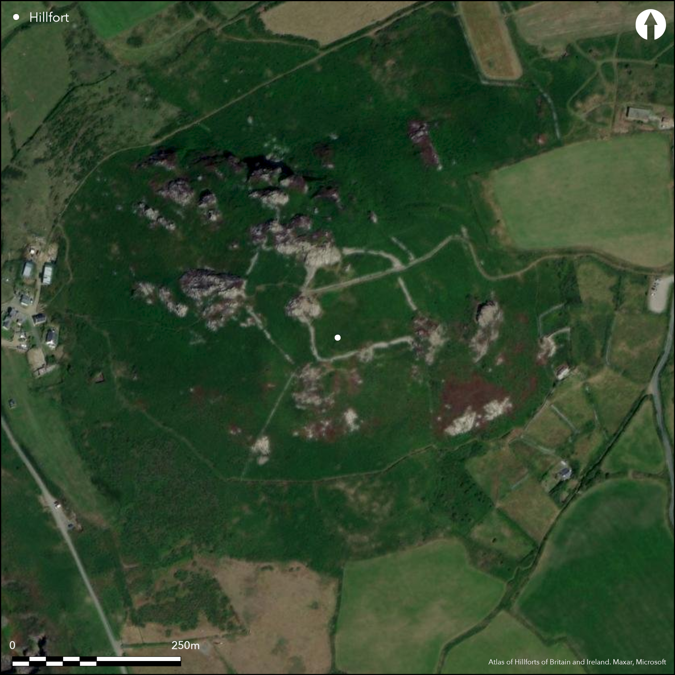
Satellite Imagery
Satellite Imagery
HER: Dyfed 2830 (None)
NMR: SM 83 NE (300425)
SM: PE065(PEM)
NGR: SM 896 388
X: 189600 Y: 238800 (OSGB36)
Great and complex stone-walled contour hillfort, formidable and dominating, located on craggy outcrop at W end of Pen-caer, the major hillfort high above Strumble Head and 280m W of the smaller Garn Fechan (Atlas No 1952) to W. Precipitous surrounding slopes to N and S, steep to W, and slightly less to E. Encircling dry-stone defences similar to Preseli forts. Possible three-phased construction. Inner central walled area, c. 110m by 85m, of c. 0.7ha, with 1m-2m high rampart and no ditch, incorporating four natural outcrops. Two outer ramparts at E end in crags. Outer rampart on W encloses an annexe. Linking walling on N and S to E and W walls. Outermost wall on E reinforced by 4m high revetted bank with ditch and counterscarp. In all, the total area, defined by the stone walls and rock outcrops, is c. 220m by 140m, with internal area c. 2.3ha. Multiple breaks but those through middle of inner, E and W walls are inturned. Modern track runs up through the centre of each rampart on E and possibly main entrance. Central roundhouse site and evidence of, maybe later, rectangular structures built against ramparts. Undated but Hadrianic-Antonine sherd found suggests later occupation. Modern well-chamber could indicate earlier supply. WWII lookout station. Under rough moorland and scrub. Notable in being one of the first British hillforts to be archaeologically surveyed, by Edward Lhuyd (1707). On 1st Ed. OS map (1889).
Citizen Science: ✗
Reliability of Data: Confirmed
Reliability of Interpretation: Confirmed
X: -564064 Y: 6801503 (EPSG: 3857)
Longitude: -5.067069607311601 Latitude: 52.00761690500058 (EPSG:4326)
Country: Wales
Current County or Unitary Authority: Pembrokeshire
Historic County: Pembrokeshire
Current Parish/Community/Council/Townland: Pencaer
Tumbled walls, but very impressive site.
| Extant | ✓ |
| Cropmark | ✗ |
| Likely Destroyed | ✗ |
Rough moorland, gorse, bracken and scrub, with bare rock. WWII lookout station.
| Woodland | ✗ |
| Commercial Forestry Plantation | ✗ |
| Parkland | ✗ |
| Pasture (Grazing) | ✗ |
| Arable | ✗ |
| Scrub/Bracken | ✓ |
| Bare Outcrop | ✗ |
| Heather/Moorland | ✓ |
| Heath | ✗ |
| Built-up | ✓ |
| Coastal Grassland | ✗ |
| Other | ✗ |
Formidable, dominating and major hillfort high above Strumble Head. Great stone-walled contour hillfort, formidable and dominating, located on craggy outcrop at W end of Pen-caer, the major hillfort high above Strumble Head. Precipitous surrounding slopes to N and S, steep to W, and slightly less to E.
| Contour Fort | ✓ |
| Partial Contour Fort | ✗ |
| Promontory Fort | ✗ |
| Hillslope Fort | ✗ |
| Level Terrain Fort | ✗ |
| Marsh Fort | ✗ |
| Multiple Enclosure Fort | ✗ |
| Hilltop | ✓ |
| Coastal Promontory | ✗ |
| Inland Promontory | ✗ |
| Valley Bottom | ✗ |
| Knoll/Hillock/Outcrop | ✗ |
| Ridge | ✗ |
| Cliff/Plateau-edge/Scarp | ✗ |
| Hillslope | ✗ |
| Lowland | ✗ |
| Spur | ✗ |
Dominant Topographic Feature: Hill top
| North | ✗ |
| Northeast | ✗ |
| East | ✗ |
| Southeast | ✗ |
| South | ✗ |
| Southwest | ✗ |
| West | ✗ |
| Northwest | ✗ |
| Level | ✓ |
Altitude: 213.0m
N/A
Undated but Hadrianic-Antonine sherd may be later occupation
Reliability: D - None
| Pre 1200BC | ✗ |
| 1200BC - 800BC | ✗ |
| 800BC - 400BC | ✗ |
| 400BC - AD50 | ✗ |
| AD50 - AD400 | ✗ |
| AD400 - AD 800 | ✗ |
| Post AD800 | ✗ |
| Unknown | ✓ |
| Pre Hillfort: | None |
| Post Hillfort: | Possible later Roman activity. |
Notable in being one of the first British hillforts to be archaeologically surveyed, by Edward Lhuyd (1707). On 1st Ed. OS map (1889). Field Observation OS 1966. Field Observation AMB 1981. Field Observation CADW 1985,1998. Cambria Archaeology defended enclosures survey 2006-2007. Survey and plan DAT 2008. Newly surveyed by Groom and Wilson for National Trust and Pembrokeshire Coast National Park Authority 2009.
| Earthwork Survey (1707): | One of the first British hillforts to be archaeologically surveyed, by Edward Lhuyd. |
| 1st Identified Map Depiction (1889): | OS map. |
| Other (1966): | Field Observation OS. |
| Other (1981): | Field Observation AMB. |
| Other (2008): | Survey and plan DAT. |
| Other (2009): | Groom and Wilson for National Trust and Pembrokeshire Coast National Park Authority. |
| Other (2011): | Visited by Hillfort Study Group |
| Other (None): | Field Observation CADW. |
| Other (None): | Cambria Archaeology defended enclosures survey. |
Central roundhouse site and evidence of, maybe later, rectangular structures built against ramparts. Hadrianic-Antonine sherd found.
Modern well-chamber could indicate earlier supply. Stream 0.95km outside fort.
| None | ✗ |
| Spring | ✗ |
| Stream | ✗ |
| Pool | ✗ |
| Flush | ✗ |
| Well | ✓ |
| Other | ✗ |
Central roundhouse site and evidence of, maybe later, rectangular structures built against ramparts.
| No Known Features | ✗ |
| Round Stone Structures | ✗ |
| Rectangular Stone Structures | ✓ |
| Curvilinear Platforms | ✗ |
| Other Roundhouse Evidence | ✓ |
| Pits | ✗ |
| Quarry Hollows | ✗ |
| Other | ✗ |
None
| No Known Excavation | ✓ |
| Pits | ✗ |
| Postholes | ✗ |
| Roundhouses | ✗ |
| Rectangular Structures | ✗ |
| Roads/Tracks | ✗ |
| Quarry Hollows | ✗ |
| Other | ✗ |
| Nothing Found | ✗ |
None
| No Known Geophysics | ✓ |
| Pits | ✗ |
| Roundhouses | ✗ |
| Rectangular Structures | ✗ |
| Roads/Tracks | ✗ |
| Quarry Hollows | ✗ |
| Other | ✗ |
| Nothing Found | ✗ |
Hadrianic-Antonine sherd found.
| No Known Finds | ✗ |
| Pottery | ✓ |
| Metal | ✗ |
| Metalworking | ✗ |
| Human Bones | ✗ |
| Animal Bones | ✗ |
| Lithics | ✗ |
| Environmental | ✗ |
| Other | ✗ |
None
| APs Not Checked | ✓ |
| None | ✗ |
| Roundhouses | ✗ |
| Rectangular Structures | ✗ |
| Pits | ✗ |
| Postholes | ✗ |
| Roads/Tracks | ✗ |
| Other | ✗ |
Multiple breaks, but those through middle of inner, E and W walls are inturned. Modern track runs up through the centre of each rampart on E and possibly main entrance.
| None: | Multiple breaks; total not defined. |
| 2: | None |
Guard Chambers: ✗
Chevaux de Frise: ✗
| 1. In-turned (East): | Through walls. |
| 2. In-turned (West): | Through walls. |
Inner central walled area, c. 110m by 85m, of c. 0.7ha,with 1m-2m high rampart with no ditch, incorporating four natural outcrops. Two outer ramparts at E end in crags, and another on W encloses an annexe. Linking walling on N and S to E and W walls. Outermost wall on E reinforced by 4m high revetted bank with ditch and counterscarp.
| Area 1: | 0.7ha. |
| Area 2: | 2.3ha. |
| Total: | 2.3ha. |
Total Footprint Area: Noneha.
None
| ✓ | Morphology suggests possible three-phased construction. |
| ✓ | Complex. Quadrants estimated. |
| NE Quadrant: | 3 |
| SE Quadrant: | 3 |
| SW Quadrant: | 2 |
| NW Quadrant: | 2 |
| Total: | 3 |
| Partial Univallate | ✗ |
| Univallate | ✗ |
| Partial Bivallate | ✓ |
| Bivallate | ✗ |
| Partial Multivallate | ✓ |
| Multivallate | ✗ |
| Unknown | ✗ |
| Partial Univallate | ✗ |
| Univallate | ✓ |
| Partial Bivallate | ✗ |
| Bivallate | ✗ |
| Partial Multivallate | ✗ |
| Multivallate | ✗ |
Stone-walled site. Outermost wall on E reinforced by 4m high revetted bank with ditch and counterscarp.
| None | ✗ |
| Earthen Bank | ✗ |
| Stone Wall | ✓ |
| Rubble | ✗ |
| Wall-walk | ✗ |
| Evidence of Timber | ✗ |
| Vitrification | ✗ |
| Other Burning | ✗ |
| Palisade | ✗ |
| Counter Scarp Bank | ✓ |
| Berm | ✗ |
| Unfinished | ✗ |
| Other | ✗ |
None
| None | ✗ |
| Earthen Bank | ✗ |
| Stone Wall | ✗ |
| Murus Duplex | ✗ |
| Timber-framed | ✗ |
| Timber-laced | ✗ |
| Vitrification | ✗ |
| Other Burning | ✗ |
| Palisade | ✗ |
| Counter Scarp Bank | ✗ |
| Berm | ✗ |
| Unfinished | ✗ |
| No Known Excavation | ✓ |
| Other | ✗ |
| ✗ | None |
| ✓ | Outermost wall on E reinforced by 4m high revetted bank with ditch and counterscarp. |
Number of Ditches: 1
| ✓ | Outer rampart on W encloses an annexe. |
Crossley, D.W. 1963. List of Hill-Forts and other earthworks in Pembrokeshire, Bull Board Celtic Stud, 20, 187.
Driver. T. 2007. Pembrokeshire: historic landscapes from the air, Aberystwyth: RCAHMW.
Hogg, A.H.A. 1973. Gaer Fawr and Carn Ingli: two major Pembrokeshire hill-forts, Arch Camb, 122, 69-84.
Lluyd, E. 1707. Archaeologia Britannica, Vol 1, Oxford: Glossography.
Murphy, K., Ramsey, R., Poucher, P. and Page, M. 2007. A Survey of Defended Enclosures in Pembrokeshire, 2006-2007: Gazetteer of Ordnance Survey Grid Squares SN73, SN83 AND SN93. Cambria Archaeology Report No. 2007/01, Project Record No. 54269, Llandeilo: Cambria Archaeology.
Rees, S. 1992. A guide to ancient and historic Wales - Dyfed, London: HMSO, 67-8.
RCAMWM 1925. An inventory of the ancient monuments in Wales and Monmouthshire, VII, County of Pembroke, London: HMSO, No. 554.
Atlas of Hillforts:
Wikidata:
This work is licensed under CC BY-SA 4.0

 and should be cited as:
Lock, Gary and Ralston, Ian. 2024. Atlas of Hillforts of Britain and Ireland. Available at: https://hillforts.arch.ox.ac.uk
Document Version 1.1